
Wyoming / Rockies
Green River
An upper Green River report centered on the Warren Bridge gauge, the WGFD easement, and the BLM river-access chain north of Pinedale.
Image: Generated Green River Warren Bridge planning image / BlueStreamFly generated; not exact location / BlueStreamFlyFishability now: Green River fishability today
GreatData confidence: High96/100
Fishable now because WARREN BRIDGE gauge is falling, weather is mild, and no public alert is active.
Flow observed
4:45 PM UTC
Weather observed
5:00 PM UTC
Score calculated
5:25 PM UTC
Why this rating
Flow
Weather
Public alerts
Next 6-12 hours
Improving / hold
A falling gauge and usable weather should keep the next 6-12 hours in play unless tributaries stain or heat builds.
USGS flow
1,030 cfs
Current trend: flow falling, rating likely holding strong unless weather or clarity changes.
More planning details: flies, flow bands, and live source checks
Fish it today
Start here
Check 09188500 early, start at the bridge corridor or the easement for a reality check, then either settle into one public access node or commit to a simple BLM float.
Best flow clue
Best once runoff drops into visible seams and the banks stop feeling bank-full. Stable summer and early-fall trends are the most flexible planning windows.
Skip trigger
Skip when the river still owns the grass, when wind ruins boat control, or when late-summer warmth turns the day into a short dawn-only option.
Flow decision bands
Dropping runoff
The first stable or slowly falling Warren Bridge trend with defined banks is the best upper-Green signal.
Wade or short float
Pick the easement, a BLM access node, or a simple float before choosing flies.
High cold push
Bank-full snowmelt or fast cold water should turn the day into scouting or a backup plan.
Wind and road check
Open-valley wind, rough roads, or limited parking can make good water hard to use.
USGS flow
1,030 cfs
Current trend: flow falling, rating likely holding strong unless weather or clarity changes.
Live USGS flow
1,030 cfs / falling about 30%
Live NWS forecast
64F / Sunny
Water temperature not verified
Heat guidance uses weather and river type unless an official water-temperature value is available.
No NWS alert flag
No active NWS alert was returned for this forecast point.
WGFD says the Warren Bridge public access easement is open year-round but the parking area is not plowed in winter.
That same WGFD page says the access road is an unimproved two-track that ends short of the river bank.
BLM says the broader Warren Bridge river-access area has 12 camp areas along roughly nine miles of river, with boat ramps at sites 1, 2, 4, and 12.
WGFD's instream-flow page calls this upper Green segment one of the state's most heavily used and productive fisheries.
Editorial review
How this report is maintained
This report starts with official regulation, access, flow, weather, and public-land sources, then adds practical planning guidance for fly anglers.
Byline
BlueStreamFly editorial desk
Reviewed by
BlueStreamFly source review
Maintained by
BlueStreamFly
Last material review
2026-06-02
Report confidence
High confidence
90/100
High confidence: Wyoming regulation, WGFD Warren Bridge access and instream-flow context, BLM river-access information, RiverReports and USGS 09188500 flow, weather coverage, generated media disclosure, and route-specific upper-Green guidance support the page. Confidence is moderated by runoff, wind, rough roads, limited parking, and float logistics.
Regulations
Wyoming regulation, 2026 change notes, and WGFD upper-Green rule context support current legal checks.
Access
WGFD Warren Bridge and BLM river-access sources provide strong public access anchors, with road, launch, camping, and parking checks still needed.
Flow and weather
RiverReports, USGS 09188500 at Warren Bridge, and the National Weather Service point support live flow and weather decisions.
Fishing usefulness
The page now separates upper-Green scope, wade-versus-float choice, runoff, wind, road and camping logistics, heat restraint, and backup-water choices.
Fishability dashboard and source review
2026-06-02 / material content or source review
Wyoming fishing regulations, 2026 regulation-change information, WGFD Warren Bridge access and instream-flow context, BLM Warren Bridge river access, RiverReports and USGS 09188500 flow, National Weather Service data, and route-specific media-credit sources were checked before updating the current-fishability decision layer.
2026-06-02
Updated Green River Warren Bridge to the current fishability-page standard with upper-Green flow bands, easement and BLM access cards, backup cues, stable fishability SEO, and confidence signals.
2026-05-28
Published a new Warren Bridge Green River report with WGFD and BLM access guidance, gauge-backed runoff judgment, and upper-basin trip planning.
Angler planning edge
Local details that change the plan
Best for
upper-basin trout planning, public-access scouting with optional short float, post-runoff summer and early-fall days
Wade or float
Start by treating Warren Bridge as a wade-or-short-float decision, not a mandatory full float. The public bank options are good enough to justify a partial day if conditions are only fair.
Best flows
Best once runoff drops into visible seams and the banks stop feeling bank-full. Stable summer and early-fall trends are the most flexible planning windows.
When to skip
Skip when the river still owns the grass, when wind ruins boat control, or when late-summer warmth turns the day into a short dawn-only option.
Local plan
Check 09188500 early, start at the bridge corridor or the easement for a reality check, then either settle into one public access node or commit to a simple BLM float.
Pressure
This is one of the state's better-known upper Green corridors, so the easiest bridge-adjacent and camp-area spots see the quickest traffic on summer weekends.
Access nuance
The easement gives you a legal starting point, but the road is rough and the best broader-day flexibility comes from understanding the separate BLM camp and launch nodes.
Backup water
If runoff, wind, or heat make Warren Bridge a poor call, pivot to a completed Snake River or Wind River plan instead of forcing a famous-name day.
About the river
Setting, character, and why it fishes the way it does.
The Warren Bridge corridor is one of the few upper Green reaches where public planning can stay honest. The gauge sits on the same water anglers actually use, and both WGFD and BLM publish access details that narrow the page to a real place instead of a vague statewide Green River idea.
WGFD's easement gives you a simple, no-nonsense starting point: public fishing access on a 40-acre easement with a rough approach and no camping or fires. That is useful because it tells you exactly what this page is not. It is not a resort-tailwater plan and it is not a generic lower-Green float page.
BLM broadens the picture by adding a network of camp and launch sites along the same upper-river corridor. Together, the two sources make Warren Bridge a practical choose-your-style day: a quick wade, a camp-based float, or a scouting stop before you commit to a full upper-basin day.
Target species
Brown trout
The dominant trout species in WGFD's instream-flow summary and a major reason the reach fishes well once the river settles.
Rainbow trout
Present in lower numbers but still part of the upper Green mix around Warren Bridge.
Mountain whitefish
Common enough to be part of the official access and fishery descriptions for this corridor.
Cutthroat trout
Present in low numbers according to WGFD's instream-flow write-up, so handle native fish carefully.
Reading the water
Dropping runoff
The best signal is the first return of defined bank seams and wadable inside edges, not just a lower graph line.
Stable summer flow
Best for mixing short wades with an easy upper-Green float or a camp-area walk-and-fish day.
High cold push
Usually a pass for wading and often a sign to scout only or choose another completed report.
Low warm late season
Fish early, keep trout handling short, and do not force a full-day plan if temperatures climb.
Best seasons
Late spring
Only after runoff starts giving back real edges and the access roads make sense.
Summer
The broadest window for upper-Green dry-dropper, nymph, and short-float planning.
Early fall
Often the cleanest mix of steady flows, lighter crowds, and cool enough water.
Winter
Possible only for committed cold-weather anglers when road and parking access remain workable.
Preferred flow source
GREEN RIVER AT WARREN BRIDGE, NEAR DANIEL, WY
RiverReports is the preferred chart source when coverage exists. When a matching USGS gauge exists, keep it open as the official backstop for station data and current hydrograph context.
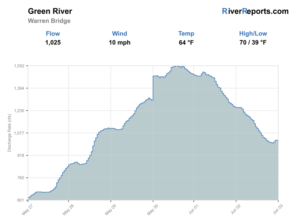
USGS data chart
Official USGS trend
Streamflow over the latest USGS reporting window.
Latest
1,030 cfs
Jun 3, 4 PM UTC
Weather
River weather report
Weather can change wading safety, road access, water temperature, hatches, and the best time of day to fish.
Live forecast loads as you reach this section
This keeps the report fast while still using the official National Weather Service forecast point.
Hatches and flies
Hatch chart and fly picks
March to April
Midges, little black stones, BWOs, and cold-water nymph windows
Zebra midge, black stonefly, BWO emerger, pheasant tail, perdigon
May to June
Runoff edges, caddis, PMDs, and stonefly activity once the river stops flooding the banks
Stonefly nymph, caddis pupa, PMD emerger, elk hair caddis, rubber legs
July to September
Caddis, PMDs, terrestrials, ants, beetles, and hopper banks
Chubby Chernobyl, hopper, ant, beetle, X-caddis, parachute Adams
October to winter
BWOs, midges, and short streamer windows in colder water
BWO emerger, midge pupa, olive bugger, sculpin, soft hackle
Dry flies
Chubby Chernobyl, parachute Adams, PMD, BWO, elk hair caddis, ant, beetle
Best when the upper Green settles into summer clarity and fish start using the banks and slicks.
Nymphs
Pheasant tail, hare's ear, perdigon, zebra midge, caddis pupa, stonefly
The safest starting point for windy days, colder mornings, and shoulder-season flows.
Streamers
Olive bugger, black leech, small sculpin, sparse articulated baitfish
Useful on cloudy afternoons, higher color, or when bigger browns hold tight to cutbanks and logjams.
Tactics
How to fish it
Use the WGFD easement for the simplest public first look before you commit to a longer float or camp-road hop.
On stable summer days, cover bank seams, log structure, and softer inside bends instead of forcing mid-river hero shots.
If the wind comes up, shrink the day and fish one access node well rather than burning time bouncing between launches.
When runoff is close but not gone, judge the day by edge quality and clarity, not by how famous the upper Green is.
Rigging
Rod, leader, and setup notes
A 5-weight with a dry-dropper and a compact nymph rig covers most Warren Bridge days.
Carry a small streamer option for cloudy afternoons, cutbanks, and logjam water where bigger browns hold tight.
Longer leaders help in calm clear water, but shorter controlled drifts and enough weight matter more when the river still has push.
Access
Access and planning notes
Warren Bridge public easement
Fast public wade checkWade / float / trail
WGFD easement / bank / wade
When to pick it
Start here when stable flow and manageable wind support a short legal session.
Caution
The two-track road, no-camping rules, and winter parking limits still matter.
BLM river-access sites
Camp road and float planningWade / float / trail
BLM access / camp / boat
When to pick it
Use these when you want a wider upper-Green day with confirmed launch or camp logistics.
Caution
Road condition, four-wheel-drive needs, and limited parking can change quickly.
Warren Bridge gauge
Primary live trendWade / float / trail
RiverReports / USGS gauge
When to pick it
Use this before deciding if the river is a wade, float, or scout-only day.
Caution
Flow alone does not settle wind, road, or access pressure.
WGFD says the Warren Bridge easement is a 40-acre public easement with an unimproved two-track access road that stops short of the river bank.
That same access page says no overnight camping, open fires, or fireworks are allowed on the easement, and the parking area is not plowed in winter.
BLM says the larger river-access area includes 12 camp areas along about nine miles of river and that parking can be limited at smaller sites.
BLM also notes that four-wheel drive may be needed at times even though most standard vehicles can reach the main riverside camps in good conditions.
Regulations
Check before fishing
Check Wyoming regulations and 2026 changes before fishing. WGFD's upper-Green instream-flow page says Area 4 flowing-water rules apply on this reach, including a three-trout limit with only one trout over 16 inches and only one cutthroat trout.
Primary base
Pinedale, Daniel, and the Highway 191 upper Green corridor
Best day style
Public easement scouting, BLM river-road pull-offs, camp-area launches, and short-float or wade plans
Check first
Wyoming regulations, 2026 changes, the 09188500 trend, bridge-area road conditions, and whether wind or runoff undercuts your wade plan
Safety
Cold snowmelt current, soft grassy banks, fast spring push, open-valley wind, and unimproved access roads
Gear
Helpful gear for this water
4- to 6-weight rod
A 5-weight is the simplest all-around Warren Bridge choice for dries, nymphs, and wind.
Wading staff
Helpful when grassy banks hide soft entries or the river still has runoff push.
Wind layer
The open upper-Green valley can feel calm at the truck and harsh once you step to the water.
Thermometer
Useful in late summer when low warm afternoons can turn a famous river into a short morning-only plan.
Nearby water
Other water to research
Backup logic
Runoff still owns the banks
Wait for softer edges or compare Snake River and Wind River.
Wind
Shorten to a protected bank session or skip the float.
Road or launch issue
Stay with the easement or choose another Wyoming route rather than forcing BLM-road logistics.
Heat
Fish early and keep trout handling short if late-season warmth builds.
New Fork
A nearby Sublette County alternative when you want a different upper-basin profile, though it still needs BlueStreamFly buildout.
Snake River
A more famous Wyoming float-and-wade option with different access, pressure, and scenery.
Wind River
A completed Wyoming backup when weather, runoff, or travel plans push you toward central-state trout water instead.
FAQ
Fast answers
Is Green River fishable today?
Green River looks very fishable right now. The live score is 96/100, based on current flow, weather, public alerts, and the report's planning context. Recheck the linked gauge and forecast before leaving because conditions can change quickly after rain, heat, access changes, or flow swings.
What flow is best for Green River?
Best once runoff drops into visible seams and the banks stop feeling bank-full. Stable summer and early-fall trends are the most flexible planning windows.
When should I skip Green River?
Skip when the river still owns the grass, when wind ruins boat control, or when late-summer warmth turns the day into a short dawn-only option.
Is Green River safe to wade right now?
The fishability score is not a wading guarantee. Wade only where your chosen access has safe edges, clear footing, legal entry, and no forced crossings; high, rising, stained, or storm-affected water should be treated conservatively.
Is Warren Bridge a wade river or a float river?
It can be either, but this page is built around short public wades first and simple public launch planning second. Let the gauge, wind, and road conditions decide whether a float is worth the extra work.
What should I watch besides the gauge at Warren Bridge?
Watch for wind, soft banks, road and launch conditions, and whether the river has defined safe edges instead of a bank-full push.
Why is this page narrower than a generic Wyoming Green River report?
Because the upper Green changes character, access, and regulation context across long distances. Warren Bridge is one reach where the public access and the gauge line up cleanly enough to support a trustworthy report.
When is Warren Bridge worth skipping?
Skip when runoff still fills the banks, when the unimproved roads are a bad bet, or when wind makes a boat day harder than the fishing is worth.
Sources
Source set for this report
Reviewed 2026-06-02