West Virginia / Southeast
Seneca Creek
A Seneca Rocks and backcountry planning report for Seneca Creek, with special-regulation guardrails, access context, hatches, and no-gauge flow guidance.
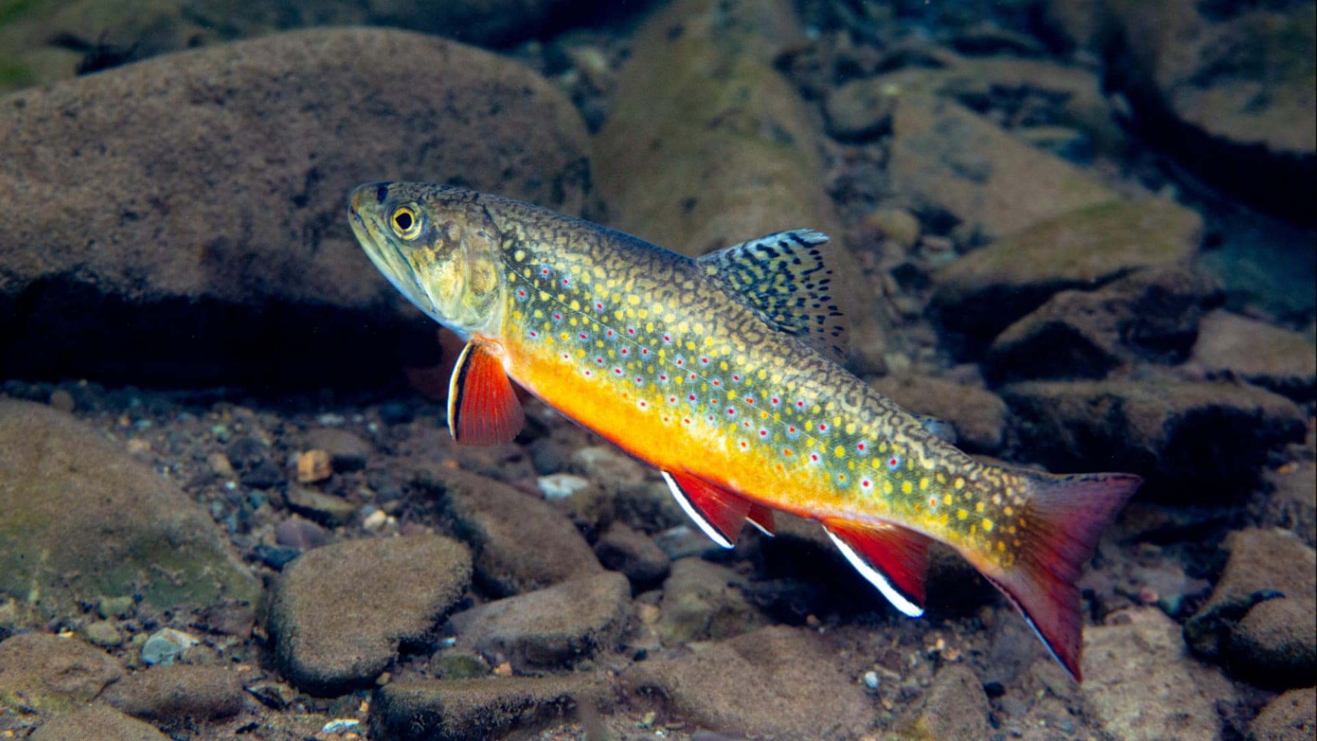
Image: Brook trout Seneca Creek West Virginia 7 November 2019 / Public domain / Ryan Hagerty/USFWSFishability now: Seneca Creek fishability today
UnknownData confidence: Medium44/100
Check live sources first because flow has been checked, weather is mild, and no public alert is active.
Flow observed
Not returned
Weather observed
5:00 PM UTC
Score calculated
5:25 PM UTC
Why this rating
Flow
Weather
Public alerts
Next 6-12 hours
Hold
Wait for a better live check before committing the drive or choosing a wading plan.
Flow check
No live chart
Current trend: previous-score comparison will become more useful after repeated live checks.
More planning details: flies, flow bands, and live source checks
Fish it today
Start here
Choose the mouth reach or the backcountry first, then pair WVDNR rule checks with USFS trail status, weather, water treatment, and a realistic exit time before selecting flies.
Best flow clue
No verified current public gauge is used for the fishing reach. Use recent rain, field clarity, trail condition, the National Weather Service point, and an on-site temperature check before committing.
Skip trigger
Skip or change the plan when water is rising or opaque, special-regulation boundaries are unclear, trails are muddy or storm-damaged, crossings are risky, summer water is warm, or the day depends on one crowded roadside pool.
Flow decision bands
No current live gauge
Use recent rain, field clarity, trail condition, weather, and on-site temperature instead of a live CFS target.
Mouth reach or backcountry
Choose the short Seneca Rocks reach or the upper backcountry first; they are different trip styles.
Storm, crossings, or trail trouble
Muddy water, risky crossings, or poor trail conditions should cancel or reroute the plan.
Warm small water
Summer heat should trigger a thermometer check and conservative trout handling.
Flow check
No live chart
Current trend: previous-score comparison will become more useful after repeated live checks.
No structured live flow
Use the linked flow and access sources before deciding.
Live NWS forecast
72F / Sunny
Water temperature not verified
Heat guidance uses weather and river type unless an official water-temperature value is available.
No NWS alert flag
No active NWS alert was returned for this forecast point.
Verify the short special-regulation water and nearby North Fork context before fishing.
Use recent rain and field clarity checks because a direct current gauge is not verified.
Backcountry travel needs weather, trail, water-treatment, and daylight planning.
Keep the fishing plan simple: small dries, nymphs, and streamers matched to clear mountain water.
Editorial review
How this report is maintained
This report is maintained from current regulation, access, flow, weather, and public planning sources so anglers can make better trip decisions than a raw gauge or generic overview would allow.
Byline
BlueStreamFly editorial team
Reviewed by
BlueStreamFly source review
Maintained by
Mountain Brook Run LLC
Last material review
2026-06-01
Report confidence
Good confidence
84/100
Good confidence: WVDNR regulation and trout-map sources, USFS backcountry and Seneca Rocks sources, weather coverage, USGS station context, exact public-domain media, and route-specific no-gauge guidance support the page. Confidence is moderated by the lack of a current live gauge, short reach scope, trail conditions, and private or posted edges near access.
Regulations
WVDNR sources support the special-regulation check path and help keep Seneca Creek separate from nearby North Fork South Branch rules.
Access
USFS and WVDNR sources support orientation, but parking, posted land, exact banks, and trail conditions need current confirmation.
Flow and weather
The National Weather Service point and USGS station context are attached, but no verified current live gauge is used for the fishing reach.
Fishing usefulness
The page now separates mouth-reach rules, backcountry travel, no-gauge planning, water temperature, pressure, and backup-water decisions.
Fishability dashboard and source review
2026-06-01 / material content or source review
West Virginia regulation, trout-map, public-access, Monongahela National Forest backcountry and Seneca Rocks sources, USGS Seneca Creek station context, National Weather Service data, and public-domain media-credit sources were checked before updating the current-fishability decision layer.
2026-06-01
Updated Seneca Creek to the current fishability-page standard with no-current-gauge decision bands, mouth-reach and backcountry access cards, backup cues, stable fishability SEO, and confidence signals.
2026-05-29
Added Seneca Creek trip-fit guidance, no-current-gauge planning, mouth-reach versus backcountry separation, trail and water-treatment cautions, backup-water suggestions, editorial review signals, and a page-specific confidence meter after source review.
2026-05-24
Initial source-reviewed report published with flows, weather, hatches, flies, tactics, access, regulations, and FAQs.
Angler planning edge
Local details that change the plan
Best for
West Virginia trout anglers choosing between the short Seneca Rocks mouth reach and a separate upper backcountry hike-fish plan, Small-stream dry, dry-dropper, and light-nymph sessions where rule boundaries, recent rain, clarity, and water temperature matter before fly choice, Anglers who need a clear no-current-gauge plan instead of borrowing a misleading nearby river flow, Trips that can shift to Shavers Fork, Elk River, or Second Creek when Seneca Creek is high, warm, crowded, or trail-limited
Wade or float
Treat Seneca Creek as a walk-and-wade report with two different trip styles: the short special-regulation mouth reach and the more remote upper backcountry. Do not plan it like a long float or one uniform fishery.
Best flows
No verified current public gauge is used for the fishing reach. Use recent rain, field clarity, trail condition, the National Weather Service point, and an on-site temperature check before committing.
When to skip
Skip or change the plan when water is rising or opaque, special-regulation boundaries are unclear, trails are muddy or storm-damaged, crossings are risky, summer water is warm, or the day depends on one crowded roadside pool.
Local plan
Choose the mouth reach or the backcountry first, then pair WVDNR rule checks with USFS trail status, weather, water treatment, and a realistic exit time before selecting flies.
Pressure
Pressure concentrates near easy Seneca Rocks access and the short managed reach. Backcountry effort spreads anglers out but adds weather, trail, and water-treatment risk.
Access nuance
USFS sources support the backcountry framework and WVDNR sources support the legal-check path, but parking, posted land, reach boundaries, trail condition, and stream crossings still need day-of confirmation.
Backup water
If Seneca Creek is high, warm, unclear, crowded, or trail-limited, compare Shavers Fork River, Elk River, or Second Creek before forcing the same plan.
About the river
Setting, character, and why it fishes the way it does.
Seneca Creek drains high country in the Monongahela National Forest before reaching the North Fork South Branch Potomac near Seneca Rocks.
The water has real fly-fishing appeal, but the useful page must be precise. The mouth-area special regulation and the upper trail country are different trips.
Expect clear water, pocket structure, and wild-feeling access. A good angler plan includes weather, route finding, and a backup option if the creek is too high or too warm.
Target species
Brook trout
Likely in colder upper tributary and backcountry context; handle carefully.
Rainbow trout
May be part of managed trout opportunity near accessible reaches.
Brown trout
Possible in larger pools and lower reaches; use stealth in clear water.
Reading the water
Clear mountain flow
Use dries, dry-droppers, and small nymphs through pocket water.
Fresh rain bump
Fish edges only after the creek starts clearing and footing is safe.
High or opaque
Skip backcountry crossings and use the day for scouting.
Low warm water
Fish early, check temperature, and stop before trout handling becomes stressful.
Best seasons
Spring
Good water and hatches, but rain and snowmelt can raise the creek quickly.
Summer
Best in shaded, cool periods; watch temperature and crowds near easier access.
Fall
Clear water, terrestrials, and small streamers make careful fishing worthwhile.
Winter
Short sessions and trail caution; expect ice, cold water, and limited daylight.
Flow
Seneca Creek near Seneca Rocks
No verified current live gauge is used for the fishing reach. Use recent rain, field clarity, trail condition, weather, and on-site temperature before committing.
Official water source
USGS 01605900 Seneca Creek near Onego station context
This station is included as official watershed context, not as a current live discharge trigger for the Seneca Rocks fishing reach.
Open official sourceWeather
River weather report
Weather can change wading safety, road access, water temperature, hatches, and the best time of day to fish.
Live forecast loads as you reach this section
This keeps the report fast while still using the official National Weather Service forecast point.
Hatches and flies
Hatch chart and fly picks
March to April
Quill Gordons, Blue Quills, midges, early caddis, and stocked-trout nymphing
Quill Gordon, Blue Quill, zebra midge, caddis pupa, hare's ear
May to June
March Browns, sulphurs, Light Cahills, caddis, and evening spinners
March Brown, sulphur emerger, Light Cahill, elk hair caddis, rusty spinner
July to September
Terrestrials, ants, beetles, small olives, and shaded attractor water
Foam ant, beetle, small hopper, BWO emerger, yellow stimulator
October to February
BWOs, midges, small stones, streamers, and slow winter nymphing
BWO emerger, midge pupa, stonefly nymph, olive bugger, soft hackle
Dry flies
BWO, sulphur, elk hair caddis, parachute Adams, ant, beetle, small hopper
Use when trout feed on top, when the water is clear, or when a dry-dropper needs a visible point fly.
Nymphs
Pheasant tail, hare's ear, perdigon, scud, caddis pupa, zebra midge
Use when flows are cold, high, bright, or when spring-creek trout stay close to the bottom.
Streamers
Olive bugger, sculpin, small leech, sparkle minnow, black woolly bugger
Use around banks, wood, undercuts, and stained water after the stream settles from rain.
Tactics
How to fish it
Treat the mouth and backcountry sections as separate plans with separate access risk.
Fish dry-droppers through pocket water and switch to a single dry when trout look up.
Use small streamers only when water is safely up and slightly stained.
Step around shallow spawning or nursery water and keep fish in the water.
Carry enough time to hike out before dark if you leave the road corridor.
Rigging
Rod, leader, and setup notes
A 3 to 5-weight rod covers most Seneca Creek fly plans.
Use 4X to 6X leaders and small weighted nymphs for pocket water.
Bring a compact rain layer, water treatment, and a headlamp for backcountry plans.
Use barbless flies when required or when release speed matters.
Access
Access and planning notes
Seneca Rocks mouth reach
Short managed-water planWade / float / trail
Walk-and-wade / rules check
When to pick it
Start here when rule boundaries, parking, clarity, and temperature are all clear.
Caution
The reach is short; pressure and posted edges can change the day quickly.
Seneca Creek Backcountry
Remote hike-fish planWade / float / trail
Trail / wade / backcountry
When to pick it
Use this when trail condition, weather, water treatment, and exit timing are realistic.
Caution
Backcountry effort adds crossing, storm, and travel risk.
USGS station context
Watershed backgroundWade / float / trail
Background source / no live trigger
When to pick it
Use it only as context while relying on weather, trail, clarity, and field checks.
Caution
It is not a current live discharge trigger for the fishing reach.
A direct current gauge was not verified for the fishing reach.
Backcountry water crossings can become unsafe after rain.
Do not conflate the Seneca Creek reach with separate North Fork South Branch rules.
Regulations
Check before fishing
Check current WVDNR regulations for Seneca Creek and nearby Seneca Rocks water before fishing. Special-regulation boundaries are short and should be verified directly.
Primary base
Seneca Rocks, Riverton, and Elkins
Best day style
Short special-reg reach plus backcountry trail planning
Check first
WVDNR regulations, Monongahela access status, recent rain, trail conditions, and weather
Safety
Remote trails, cold mountain weather, slippery crossings, and no direct gauge
Gear
Helpful gear for this water
4 or 5-weight rod
Good for most trout dries, nymphs, and small streamers.
Thermometer
Use it before handling trout in summer or after warm nights.
Wading staff
Small streams still have slick limestone, ledges, and undercut banks.
3X to 6X tippet
Carry heavier tippet for streamers and lighter tippet for clear dry-fly water.
Nearby water
Other water to research
Backup logic
High or opaque water
Compare Shavers Fork, Elk River, or Second Creek instead of forcing a no-gauge creek.
Trail or crossing risk
Stay out of the backcountry plan and choose a better-accessed trout river.
Heat
Check temperature, fish only cool windows, or move to colder water.
Crowding
Leave the short mouth reach room and use a larger backup.
Shavers Fork River
A larger Monongahela trout river with live USGS flow.
Elk River
A West Virginia trout option with more developed access.
Second Creek
A focused small-stream special-regulation trout plan.
FAQ
Fast answers
Is Seneca Creek fishable today?
Seneca Creek needs a live-condition check before you commit. The live score is 44/100, based on current flow, weather, public alerts, and the report's planning context. Recheck the linked gauge and forecast before leaving because conditions can change quickly after rain, heat, access changes, or flow swings.
What flow is best for Seneca Creek?
No verified current public gauge is used for the fishing reach. Use recent rain, field clarity, trail condition, the National Weather Service point, and an on-site temperature check before committing.
When should I skip Seneca Creek?
Skip or change the plan when water is rising or opaque, special-regulation boundaries are unclear, trails are muddy or storm-damaged, crossings are risky, summer water is warm, or the day depends on one crowded roadside pool.
Is Seneca Creek safe to wade right now?
The fishability score is not a wading guarantee. Wade only where your chosen access has safe edges, clear footing, legal entry, and no forced crossings; high, rising, stained, or storm-affected water should be treated conservatively.
What should I check before fishing Seneca Creek?
WVDNR regulations, Monongahela access status, recent rain, trail conditions, and weather
Which flow should I use for Seneca Creek?
There is no direct current Seneca Creek gauge used here. Use recent rain, trail reports, and on-site clarity instead of a misleading nearby substitute.
Where should I start on Seneca Creek?
Start at Seneca Rocks for the short mouth-area plan, or build a separate backcountry plan through Monongahela National Forest access sources.
Can I wade Seneca Creek?
Yes in normal clear flows, but crossings become risky after rain and in cold high water.
Sources
Source set for this report
Reviewed 2026-06-01