
South Dakota / Midwest
Rapid Creek Below Pactola
A Rapid Creek below Pactola report for anglers planning the spillway and trail-access tailwater corridor with flow checks, public access, and disciplined trout wading.
Image: Generated regional planning image for Rapid Creek Below Pactola / BlueStreamFly generated; not exact location / BlueStreamFlyFishability now: Rapid Creek Below Pactola fishability today
GreatData confidence: High96/100
Fishable now because the live gauge is stable, weather is mild, and no public alert is active.
Flow observed
4:15 PM UTC
Weather observed
5:00 PM UTC
Score calculated
5:27 PM UTC
Why this rating
Flow
Weather
Public alerts
Next 6-12 hours
Hold
Stable live data supports staying with the plan, but recheck the gauge and forecast before leaving.
USGS flow
35 cfs
Current trend: flow stable, so weather, temperature, and access checks drive the next change.
More planning details: flies, flow bands, and live source checks
Fish it today
Start here
Start with the below-Pactola gauge, then choose the Rapid Creek Trailhead or spillway corridor before picking flies.
Best flow clue
Use the below-Pactola gauge first. Stable or slowly falling flow with safe edges is the best signal.
Skip trigger
Skip when the below-dam flow is rising, wading lanes are pushy, thunderstorms are active, water is warm, or crowding leaves no safe room.
Flow decision bands
Stable below-Pactola flow
Stable USGS 06411500 flow with safe wading edges and cool weather is the best below-Pactola signal.
Best short tailwater window
Mild weather, manageable current, trailhead access, and no crowding make short wade sessions most useful.
Rising or pushy
Rising below-dam water can turn slick-rock wading unsafe quickly; stay bank-first or leave.
Warm, stormy, or crowded
Heat, thunderstorms, or crowded access should shorten the session or push it to another Black Hills route.
USGS flow
35 cfs
Current trend: flow stable, so weather, temperature, and access checks drive the next change.
Live USGS flow
35 cfs / stable
Live NWS forecast
67F / Mostly Sunny
Water temperature not verified
Heat guidance uses weather and river type unless an official water-temperature value is available.
No NWS alert flag
No active NWS alert was returned for this forecast point.
Black Hills National Forest says the Rapid Creek Trailhead & Fishing Access sits in the Pactola basin, is free to use, and gives anglers direct access beside the creek below the dam.
The Pactola Reservoir Complex page says fly fishing below the spillway is exceptional and notes large brown trout are caught above and below the reservoir.
The Black Hills stream management plan says popular Rapid Creek access includes the immediate areas above and below Pactola Reservoir reached by short gravel roads and parking areas.
This route fishes differently from upper Rapid Creek above Pactola. Below the dam, the day is tighter, colder, and more about clean presentation in a defined corridor than about roaming headwater mileage.
Editorial review
How this report is maintained
This report starts with official regulation, access, flow, weather, and public-land sources, then adds practical planning guidance for fly anglers.
Byline
BlueStreamFly editorial desk
Reviewed by
BlueStreamFly source review
Maintained by
BlueStreamFly
Last material review
2026-06-02
Report confidence
High confidence
91/100
High confidence: RiverReports, USGS below-Pactola flow, Black Hills National Forest Rapid Creek Trailhead and Pactola Reservoir Complex sources, South Dakota GFP stream plan and regulations, weather coverage, image disclosure, and route-specific tailwater guidance support the page. Confidence is moderated by release timing, slick rock, concentrated public access, storms, and summer heat.
Regulations
South Dakota GFP regulations and Black Hills stream-plan sources support the trout-rule and species-check path.
Access
Black Hills National Forest Rapid Creek Trailhead and Pactola Reservoir Complex sources strongly support named public planning.
Flow and weather
RiverReports coverage is backed by USGS 06411500 below Pactola Dam, and the National Weather Service point supports storm and heat decisions.
Fishing usefulness
The page now separates below-Pactola flow, trailhead access, cold tailwater current, crowding, trout heat risk, and backup-water choices.
Fishability dashboard and source review
2026-06-02 / material content or source review
RiverReports, USGS 06411500 below Pactola Dam, Black Hills National Forest Rapid Creek Trailhead and Pactola Reservoir Complex sources, South Dakota GFP Black Hills stream plan, fishing-regulation sources, image-disclosure, and National Weather Service sources were checked before updating the current-fishability decision layer.
2026-06-02
Updated Rapid Creek Below Pactola to the current fishability-page standard with below-dam trend bands, Rapid Creek Trailhead and Pactola access cards, cold-tailwater skip cues, stable fishability SEO, and confidence signals.
2026-05-27
Published a new Rapid Creek below Pactola report with spillway access guidance, tailwater trout planning, and Black Hills safety context.
Angler planning edge
Local details that change the plan
Best for
below-Pactola tailwater trout, short public-access sessions, brown trout seam fishing
Wade or float
Short wade and bank plans from the trailhead or spillway corridor; this is a compact tailwater, not a long exploratory float.
Best flows
Use the below-Pactola gauge first. Stable or slowly falling flow with safe edges is the best signal.
When to skip
Skip when the below-dam flow is rising, wading lanes are pushy, thunderstorms are active, water is warm, or crowding leaves no safe room.
Local plan
Start with the below-Pactola gauge, then choose the Rapid Creek Trailhead or spillway corridor before picking flies.
Pressure
The obvious public water fishes compact, so crowding can matter even when flow is good.
Access nuance
Forest Service Pactola sources support public access, but cold current, slick rock, and posted signs still decide the day.
Backup water
Compare upper Rapid Creek, Castle Creek Below Deerfield, or French Creek when below Pactola is high, crowded, warm, or access-limited.
About the river
Setting, character, and why it fishes the way it does.
Below Pactola is a classic compact planning reach. It is easier to verify than many Black Hills trout pages because the main access, gauge, and public corridor line up cleanly with official sources.
That does not make it casual water. The cold current, slick rock, and small tailwater feel mean the day still rewards quiet feet and disciplined wading more than rushing from bucket to bucket.
This route is also the better choice than upper Rapid Creek when you want a short session, a quick gauge-to-bank decision, and a reliable public starting point without much route-finding.
Target species
Brown trout
The Forest Service specifically points to large browns above and below the reservoir, so deeper seams deserve your best drifts.
Rainbow trout
A realistic part of the Black Hills trout mix and a normal expectation in this managed creek corridor.
Brook trout
Possible in the broader watershed, but not the main species to organize this below-dam page around.
Reading the water
Stable cool tailwater flow
Best for nymphing seams, dry-dropper work in softer pockets, and short precise presentations.
Cold clear water
Back off the bank edge, use longer leaders, and expect trout to punish noisy first approaches.
Pushy release or storm pulse
Fish only obvious bank cushions and skip any crossing-dependent plan.
Bright weekend pressure
Downsize the approach, fish the less-obvious soft water, and keep the session mobile instead of camping on the first easy seam.
Best seasons
Spring
Usually the best mix of cold water, active trout, and manageable daylight weather.
Early summer
Still strong when storms stay reasonable and you fish early or late.
Fall
A reliable planning window for cleaner weather and focused nymph or streamer sessions.
Winter
Possible on milder days because of the tailwater influence, but footing and short daylight still matter.
Preferred flow source
Rapid Creek below Pactola Dam
RiverReports is the preferred chart source when coverage exists. When a matching USGS gauge exists, keep it open as the official backstop for station data and current hydrograph context.
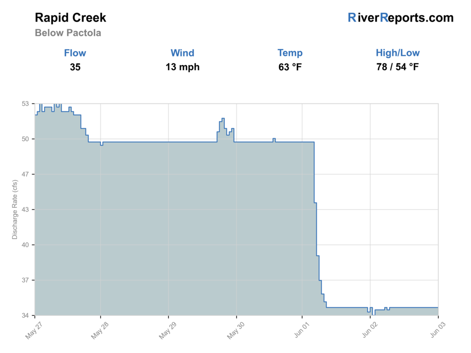
USGS data chart
Official USGS trend
Streamflow over the latest USGS reporting window.
Latest
35 cfs
Jun 3, 4 PM UTC
Weather
River weather report
Weather can change wading safety, road access, water temperature, hatches, and the best time of day to fish.
Live forecast loads as you reach this section
This keeps the report fast while still using the official National Weather Service forecast point.
Hatches and flies
Hatch chart and fly picks
March-May
Blue-winged olives, midges, little black stones, caddis
BWO nymph, zebra midge, black stonefly, caddis pupa
May-June
Caddis, yellow sallies, mayfly windows
Soft hackle, hare's ear, yellow stimulator
Summer
Caddis and terrestrials
Elk hair caddis, foam ant, beetle, prince nymph
Fall
BWOs, midges, streamer windows
RS2, zebra midge, olive bugger
Core nymphs
Pheasant tail, hare's ear, zebra midge, prince
The best default for seam fishing and short below-dam drifts.
Dry-dropper
Stimulator, parachute Adams, foam ant with a small nymph
Useful when the creek is stable and fish are willing to move in softer broken water.
Small streamers
Olive bugger, black bugger, small sculpin
Worth using early, late, or through deeper shade and cutbank seams.
Tactics
How to fish it
Start at the trailhead or spillway corridor and fish the first legal seam carefully before walking farther.
On stable flow, pick apart soft water beside the main current instead of racing straight to the deepest slot.
If the creek is higher than expected, stay bank-oriented and fish only what you can reach without hurried footing.
This reach rewards patience and angle changes more than constant rig overhauls.
Rigging
Rod, leader, and setup notes
A 7 1/2- to 9-foot 3- to 5-weight fits most below-Pactola sessions.
Carry 4X through 6X tippet and use only enough weight to keep the drift under control through one seam at a time.
Short indicator rigs and compact dry-droppers are usually easier to manage here than long multi-fly builds.
Sticky soles or studs help because the below-dam rock can stay slick even when the creek looks gentle from shore.
Access
Access and planning notes
Below-Pactola gauge
Primary release and safety checkWade / float / trail
RiverReports / USGS gauge / tailwater
When to pick it
Start here when release direction, current speed, and safe wading decide the day.
Caution
The gauge does not replace posted signs, trailhead status, or on-water judgment.
Rapid Creek Trailhead
Main public entryWade / float / trail
Forest Service / trailhead / wade
When to pick it
Use it when you want the clearest public start below Pactola Dam.
Caution
Expect slick rock, cold current, and pressure near the easiest access.
Pactola Reservoir Complex
Public-land and timing contextWade / float / trail
Reservoir complex / spillway / scout
When to pick it
Pick this context when parking, weather, or reservoir-area rules shape the day.
Caution
Reservoir access and below-dam fishing are different decisions; check the exact corridor.
Use the signed trailhead, spillway corridor, and posted public access first.
This is a shorter, clearer access plan than many Black Hills streams, but that also means the obvious water sees obvious pressure.
If the creek or weather makes you rush the walk back to the parking area, the session has already gone too far.
Regulations
Check before fishing
Recheck the 2026 South Dakota Fishing Handbook and current state regulations before fishing. Black Hills trout rules can include reach-specific details that matter here.
Primary base
Rapid City or a short Black Hills day centered on Pactola Dam access
Best day style
Short-access tailwater trout corridor with easy public entry, slick footing, and quick water-level consequences
Check first
RiverReports, USGS 06411500, Rapid Creek Trailhead access details, the Pactola complex page, and the NWS forecast
Safety
Cold tailwater current, slick rock, short-notice weather changes, crowding at obvious access, and quick consequences from poor crossings
Gear
Helpful gear for this water
3- to 5-weight rod
Enough for most nymph and dry-dropper work without overpowering short trout drifts.
Wading staff
Useful whenever the below-dam current is stronger than it looks from shore.
Layer and rain shell
Black Hills weather shifts quickly and the cold water can cool you down fast.
Polarized glasses
Helpful for reading seams and spotting slick-footing hazards before stepping in.
Nearby water
Other water to research
Backup logic
Rising below-dam flow
Use upper Rapid Creek, Castle Creek Below Deerfield, or a bank-only plan instead.
Warm trout conditions
Fish early, move to colder water, or stop trout fishing.
Crowded trailhead
Compare upper Rapid Creek or Castle Creek before forcing compact water.
Storms
Avoid slick below-dam wading and choose a route with easier exits.
Rapid Creek
The upper Silver City corridor is the better fallback when you want more room and a less concentrated tailwater feel.
Castle Creek Below Deerfield
A compact walk-in trout alternative with a different below-reservoir feel.
French Creek
The better choice when you want a more scenic and more committing Black Hills creek day.
FAQ
Fast answers
Is Rapid Creek Below Pactola fishable today?
Rapid Creek Below Pactola looks very fishable right now. The live score is 96/100, based on current flow, weather, public alerts, and the report's planning context. Recheck the linked gauge and forecast before leaving because conditions can change quickly after rain, heat, access changes, or flow swings.
What flow is best for Rapid Creek Below Pactola?
Use the below-Pactola gauge first. Stable or slowly falling flow with safe edges is the best signal.
When should I skip Rapid Creek Below Pactola?
Skip when the below-dam flow is rising, wading lanes are pushy, thunderstorms are active, water is warm, or crowding leaves no safe room.
Is Rapid Creek Below Pactola safe to wade right now?
The fishability score is not a wading guarantee. Wade only where your chosen access has safe edges, clear footing, legal entry, and no forced crossings; high, rising, stained, or storm-affected water should be treated conservatively.
What flow should I check for Rapid Creek below Pactola?
Use RiverReports for the live chart and keep USGS site 06411500 open as the official below-dam reference.
Why fish below Pactola instead of upper Rapid Creek?
Below Pactola gives you a shorter, colder, and easier-to-verify public trout corridor, which is ideal when you want a quick tailwater-style session.
Is Rapid Creek below Pactola mostly a wade fishery?
Yes. The useful plan is a short-access wade day built around the spillway and trail corridor, not a float trip.
Sources
Source set for this report
Reviewed 2026-06-02