
South Dakota / Midwest
Castle Creek Below Deerfield
A Castle Creek below Deerfield report for anglers planning the below-dam Black Hills trout water around Kinney Canyon, Deerfield Trail access, and short disciplined wading windows.
Image: Generated regional planning image for Castle Creek Below Deerfield / BlueStreamFly generated; not exact location / BlueStreamFlyFishability now: Castle Creek Below Deerfield fishability today
GreatData confidence: High96/100
Fishable now because the live gauge is stable, weather is mild, and no public alert is active.
Flow observed
4:45 PM UTC
Weather observed
5:00 PM UTC
Score calculated
5:26 PM UTC
Why this rating
Flow
Weather
Public alerts
Next 6-12 hours
Hold
Stable live data supports staying with the plan, but recheck the gauge and forecast before leaving.
USGS flow
9 cfs
Current trend: flow stable, so weather, temperature, and access checks drive the next change.
More planning details: flies, flow bands, and live source checks
Fish it today
Start here
Start with the below-Deerfield gauge, then choose Kinney Canyon or the Deerfield public-land corridor before rigging.
Best flow clue
Use the below-Deerfield gauge with release direction and weather. Stable or slowly falling flow is the safest signal.
Skip trigger
Skip when flow is rising, crossings are pushy, thunderstorms are active, water is warm, or the walk-in effort exceeds the day's margin.
Flow decision bands
Stable below-dam flow
Stable USGS 06410000 flow with cool weather and safe wading edges is the best below-Deerfield signal.
Best walk-in window
Mild weather, manageable current, clear trail conditions, and legal access make Kinney Canyon most useful.
Rising or pushy
Rising below-dam flow can make crossings and slick-bottom wading unsafe quickly; shorten the plan or stay out.
Warm, stormy, or crowded
Heat, thunderstorms, crowded access, or a rushed return walk should move the day to a backup.
USGS flow
9 cfs
Current trend: flow stable, so weather, temperature, and access checks drive the next change.
Live USGS flow
9 cfs / stable
Live NWS forecast
65F / Mostly Sunny
Water temperature not verified
Heat guidance uses weather and river type unless an official water-temperature value is available.
No NWS alert flag
No active NWS alert was returned for this forecast point.
South Dakota Game, Fish and Parks says Castle Creek immediately below Deerfield Reservoir holds brook trout, brown trout, and occasional rainbow trout, with brown trout becoming more dominant farther downstream.
Black Hills National Forest says the Kinney Canyon Walk In Fishery follows Castle Creek for about four round-trip miles to Deerfield Dam and remains a favorite among fly fishers.
That same Forest Service page notes a 2023 access-improvement project with angler gates, fencing, and willow work, which is useful evidence that the walk-in corridor is a primary public fishing reach.
The Black Hills stream management plan says access below Deerfield is provided along Forest Service roads and through Castle Peak Campground nearly to the Rapid Creek confluence, so this page stays focused on legal public water rather than vague roadside guesses.
Editorial review
How this report is maintained
This report starts with official regulation, access, flow, weather, and public-land sources, then adds practical planning guidance for fly anglers.
Byline
BlueStreamFly editorial desk
Reviewed by
BlueStreamFly source review
Maintained by
BlueStreamFly
Last material review
2026-06-02
Report confidence
Good confidence
89/100
Good confidence: RiverReports, USGS below-Deerfield flow, Black Hills National Forest Kinney Canyon and Deerfield access sources, South Dakota GFP reservoir and stream plans, regulation sources, weather coverage, image disclosure, and route-specific tailwater guidance support the page. Confidence is moderated by release timing, trail condition, slick footing, crowding, storms, and summer heat.
Regulations
South Dakota GFP regulations plus Black Hills stream and reservoir planning sources support the rule and species-check path.
Access
Black Hills National Forest Kinney Canyon and Deerfield sources support named public planning.
Flow and weather
RiverReports coverage is backed by USGS 06410000 below Deerfield Dam, and the National Weather Service point supports storm and heat decisions.
Fishing usefulness
The page now separates below-Deerfield flow, Kinney Canyon access, tailwater current, walk-in effort, trout heat risk, and backup-water choices.
Fishability dashboard and source review
2026-06-02 / material content or source review
RiverReports, USGS 06410000 below Deerfield Dam, Black Hills National Forest Kinney Canyon walk-in and Deerfield Reservoir access sources, South Dakota GFP reservoir and stream plans, fishing-regulation sources, image-disclosure, and National Weather Service sources were checked before updating the current-fishability decision layer.
2026-06-02
Updated Castle Creek Below Deerfield to the current fishability-page standard with below-dam trend bands, Kinney Canyon and Deerfield access cards, cold-current and walk-in skip cues, stable fishability SEO, and confidence signals.
2026-05-27
Published a new Castle Creek below Deerfield report with walk-in access guidance, below-dam trout planning, and Black Hills safety context.
Angler planning edge
Local details that change the plan
Best for
below-reservoir Black Hills trout, Kinney Canyon walk-in sessions, brown trout seam fishing
Wade or float
Short wade or walk-in plans from the below-dam corridor; treat cold current, slick footing, and the return walk as part of the decision.
Best flows
Use the below-Deerfield gauge with release direction and weather. Stable or slowly falling flow is the safest signal.
When to skip
Skip when flow is rising, crossings are pushy, thunderstorms are active, water is warm, or the walk-in effort exceeds the day's margin.
Local plan
Start with the below-Deerfield gauge, then choose Kinney Canyon or the Deerfield public-land corridor before rigging.
Pressure
Obvious walk-in water can concentrate anglers, especially when the upper creek is low or warm.
Access nuance
Kinney Canyon and Deerfield sources support a public plan, but water level, trail condition, and posted signs still decide the day.
Backup water
Compare upper Castle Creek, Rapid Creek Below Pactola, or French Creek when below-Deerfield water is high, crowded, warm, or access-limited.
About the river
Setting, character, and why it fishes the way it does.
This reach is best understood as a compact reservoir-outlet trout corridor. The creek is not huge, but it has enough gradient, current change, and woody cover to punish sloppy feet and reward careful short drifts.
The access pattern matters as much as the fishery. Kinney Canyon and the below-dam trail corridor give anglers a real public plan, which is better than relying on rumor or private-lane pull-offs elsewhere in the watershed.
It also fishes differently from the upper Castle Creek water above Deerfield. Below the reservoir, keep thinking in terms of colder water, more concentrated trout habitat, and a more deliberate walk-in layout.
Target species
Brown trout
The main fish to plan around once you move downstream from the reservoir outlet corridor.
Brook trout
A realistic upper-reach target close to the below-Deerfield coldwater influence.
Rainbow trout
Present at times, but best treated as a bonus rather than the page's core species promise.
Reading the water
Stable modest flow
Best for fishing soft pocket tails, short seams, and woody cover with a nymph or compact dry-dropper.
Cold clear water
Stay back from the first run, use longer leaders, and expect trout to hold tight to shade and depth.
Pushy runoff or release effect
Fish only obvious edges and skip any plan that depends on multiple crossings.
Late-day warming
This reach usually keeps temperature margin better than open freestone water, but short sessions are still smarter than grinding through a slow afternoon.
Best seasons
Spring
Usually the strongest mix of flow, cool water, and active trout movement.
Early summer
Still good when runoff settles and you fish the first or last useful light.
Fall
A strong planning window for clearer water, steadier weather, and streamer or nymph fishing.
Winter
Fishable on milder days if access roads and trail footing cooperate, but keep the session short and conservative.
Preferred flow source
Castle Creek below Deerfield Dam
RiverReports is the preferred chart source when coverage exists. When a matching USGS gauge exists, keep it open as the official backstop for station data and current hydrograph context.
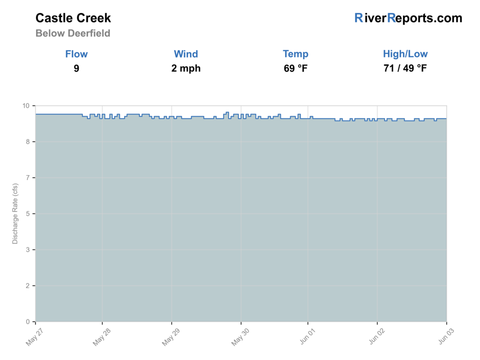
USGS data chart
Official USGS trend
Streamflow over the latest USGS reporting window.
Latest
9 cfs
Jun 3, 4 PM UTC
Weather
River weather report
Weather can change wading safety, road access, water temperature, hatches, and the best time of day to fish.
Live forecast loads as you reach this section
This keeps the report fast while still using the official National Weather Service forecast point.
Hatches and flies
Hatch chart and fly picks
March-May
Blue-winged olives, little black stones, early caddis
BWO nymph, black stonefly, tan caddis pupa
May-June
Caddis, march-brown style mayflies, yellow sallies
Soft hackle, hare's ear, yellow stimulator
Summer
Caddis and terrestrials
Elk hair caddis, foam ant, beetle, prince nymph
Fall
BWOs, midges, baitfish windows
RS2, zebra midge, olive bugger
Core nymphs
Pheasant tail, hare's ear, perdigon, prince
The best default when you need to cover short pocket water efficiently.
Dry-dropper
Yellow stimulator, parachute Adams, foam ant with a small nymph
Useful when the creek is stable enough to cover broken water quickly.
Small streamers
Olive bugger, black bugger, small sculpin
Worth fishing through deeper wood, shade, and lower-light slots.
Tactics
How to fish it
Start at the easiest legal access and fish upstream with purpose rather than hiking past good water too early.
On moderate flow, target the first soft slot beside plunge pockets before stepping into the middle of the creek.
If the creek is higher than expected, fish from the bank and cover wood, undercut edges, and current cushions instead of chasing the perfect pool.
The reach rewards quiet, compact presentations more than constant fly changes.
Rigging
Rod, leader, and setup notes
A 7 1/2- to 9-foot 3- to 5-weight fits most Castle Creek below Deerfield days.
Carry 4X through 6X tippet and only enough weight to touch the lower seam once or twice each drift.
A short indicator or dry-dropper rig is usually easier to manage here than a long heavy setup.
Sticky soles help because small Black Hills water can still be slicker than it looks from the bank.
Access
Access and planning notes
Below-Deerfield gauge
Primary release and trend checkWade / float / trail
RiverReports / USGS gauge / tailwater
When to pick it
Start here when release direction, current speed, and wade safety decide the trip.
Caution
The gauge does not replace local signs, trail condition, or on-water judgment.
Kinney Canyon walk-in
Main public fishery accessWade / float / trail
Trailhead / walk-in / wade
When to pick it
Use it when flow is stable and you want the clearest below-Deerfield fishing corridor.
Caution
Plan for the return walk, slick footing, weather changes, and concentrated angling pressure.
Deerfield Reservoir complex
Public-land contextWade / float / trail
Forest Service / reservoir corridor
When to pick it
Pick this context when access, road status, or campground timing affects the plan.
Caution
Reservoir-area access does not make every bank or crossing safe at higher water.
Focus on signed public access and Forest Service trailheads.
The Kinney Canyon reach is strong because it gives you one obvious legal corridor instead of several uncertain roadside guesses.
This is a better creek for one careful reach than for a long vehicle-hopping tour.
Regulations
Check before fishing
South Dakota's trout rules can include Black Hills exceptions. Recheck the 2026 South Dakota Fishing Handbook and current state regulations before fishing this below-Deerfield reach.
Primary base
Hill City, Rapid City, or a Black Hills day built around Deerfield Road access
Best day style
Walk-in trout access below a reservoir with short wades, trail travel, and one-way decision points
Check first
RiverReports, USGS 06410000 site backing, Kinney Canyon access details, the Black Hills stream plan, and the NWS forecast
Safety
Cold current below the reservoir, slick rock, long walk-out commitments, afternoon storms, and limited bailout crossings
Gear
Helpful gear for this water
3- to 5-weight rod
Plenty for short nymph drifts, dry-dropper work, and small streamers.
Compact day pack
Helpful for water, layers, and a short walk-in day.
Wading staff
Useful whenever the below-dam current pushes harder than expected.
Rain shell
Black Hills weather can change quickly once the day warms.
Nearby water
Other water to research
Backup logic
Rising below-dam flow
Shift to upper Castle Creek, Rapid Creek Below Pactola, or a bank-only plan.
Storm or trail risk
Choose a shorter official access or leave the walk-in water for another day.
Warm trout conditions
Fish early, move to colder water, or stop trout fishing.
Crowded corridor
Compare French Creek or upper Rapid Creek instead of stacking into short water.
French Creek
A different Black Hills trout option with more park-gorge character and a longer crossing-heavy day.
Castle Creek
The upper watershed stays separate enough that it needs its own route decision before this site publishes a second Castle Creek page.
Rapid Creek
The obvious larger-basin backup when you want more public mileage than the below-Deerfield corridor.
FAQ
Fast answers
Is Castle Creek Below Deerfield fishable today?
Castle Creek Below Deerfield looks very fishable right now. The live score is 96/100, based on current flow, weather, public alerts, and the report's planning context. Recheck the linked gauge and forecast before leaving because conditions can change quickly after rain, heat, access changes, or flow swings.
What flow is best for Castle Creek Below Deerfield?
Use the below-Deerfield gauge with release direction and weather. Stable or slowly falling flow is the safest signal.
When should I skip Castle Creek Below Deerfield?
Skip when flow is rising, crossings are pushy, thunderstorms are active, water is warm, or the walk-in effort exceeds the day's margin.
Is Castle Creek Below Deerfield safe to wade right now?
The fishability score is not a wading guarantee. Wade only where your chosen access has safe edges, clear footing, legal entry, and no forced crossings; high, rising, stained, or storm-affected water should be treated conservatively.
What flow should I check for Castle Creek below Deerfield?
Use RiverReports for the live chart and keep USGS site 06410000 open as the official below-dam location reference.
Is Castle Creek below Deerfield mostly a wade fishery?
Yes. The best plan is a walk-in wade day through Kinney Canyon or the public downstream corridor, not a float day.
What makes this reach different from upper Castle Creek?
Below Deerfield you are fishing reservoir-influenced coldwater trout habitat with a better defined walk-in public corridor and a stronger brown-trout signal downstream.
Sources
Source set for this report
Reviewed 2026-06-02