
South Dakota / Midwest
Castle Creek
An upper Castle Creek report for anglers planning the Black Hills water above Deerfield Reservoir around Forest Service Road 291, meadow-to-spruce transitions, and short technical trout sessions.
Image: Generated regional planning image for Castle Creek / BlueStreamFly generated; not exact location / BlueStreamFlyFishability now: Castle Creek fishability today
GreatData confidence: High96/100
Fishable now because the live gauge is stable, weather is mild, and no public alert is active.
Flow observed
5:00 PM UTC
Weather observed
5:00 PM UTC
Score calculated
5:26 PM UTC
Why this rating
Flow
Weather
Public alerts
Next 6-12 hours
Hold
Stable live data supports staying with the plan, but recheck the gauge and forecast before leaving.
USGS flow
13 cfs
Current trend: flow stable, so weather, temperature, and access checks drive the next change.
More planning details: flies, flow bands, and live source checks
Fish it today
Start here
Start with the above-Deerfield gauge, then choose the Forest Service Road 291 corridor or Castle Peak context before picking flies.
Best flow clue
Use the above-Deerfield trend with weather and temperature. Stable cool water is the cleanest small-creek signal.
Skip trigger
Skip when thunderstorms are active, the creek is rising or stained, water is warm, banks are slick, or public access is not confirmed.
Flow decision bands
Stable upper-creek flow
Stable above-Deerfield flow with cool weather and clear pocket water is the best Castle Creek signal.
Best road-linked window
Mild weather, public Forest Service road access, enough current, and no storm stain make short creek sessions most useful.
Rising or stained
Small Black Hills creeks can become pushy and off-color quickly after storms; wait for the trend to settle.
Warm or access-limited
Low warm water, crowded short pools, slick banks, or uncertain public access should push the plan to a backup.
USGS flow
13 cfs
Current trend: flow stable, so weather, temperature, and access checks drive the next change.
Live USGS flow
13 cfs / stable
Live NWS forecast
64F / Mostly Sunny
Water temperature not verified
Heat guidance uses weather and river type unless an official water-temperature value is available.
No NWS alert flag
No active NWS alert was returned for this forecast point.
South Dakota Game, Fish and Parks says access above Deerfield Reservoir is provided by Forest Service Road 291, which parallels Castle Creek for about two miles before continuing along Ditch Creek.
The same stream-management plan lists the Castle Creek reach from Soholt Draw to the headwaters as wild-trout management water and the reach from Forest Service Road 188 to Deerfield Dam as wild-trout water, which supports a technical trout-first plan above the lake.
The Black Hills National Forest recreation overview for Deerfield Reservoir says Castle Creek flows into and out of the reservoir and provides additional fishing opportunities, giving the upper creek a clear public-land anchor tied to the reservoir complex.
USGS classifies the 06409000 streamgage as a hydrologic benchmark station with a basin that is almost entirely forested, which matches the source-backed approach of treating this as a cold, weather-sensitive upper watershed rather than generic roadside water.
Editorial review
How this report is maintained
This report starts with official regulation, access, flow, weather, and public-land sources, then adds practical planning guidance for fly anglers.
Byline
BlueStreamFly editorial desk
Reviewed by
BlueStreamFly source review
Maintained by
BlueStreamFly
Last material review
2026-06-02
Report confidence
Good confidence
88/100
Good confidence: RiverReports, USGS above-Deerfield flow, USGS benchmark context, Black Hills National Forest access sources, South Dakota GFP stream plan and 2026 handbook, weather coverage, image disclosure, and route-specific small-creek guidance support the page. Confidence is moderated by small-water scale, road condition, storm response, limited public pockets, and summer heat.
Regulations
South Dakota GFP Black Hills stream plan and 2026 fishing handbook support the trout-rule and species-check path.
Access
Black Hills National Forest and GFP stream-plan sources support Forest Service Road 291 and Deerfield/Castle Peak planning.
Flow and weather
RiverReports coverage is backed by USGS 06409000 above Deerfield Reservoir, and the National Weather Service point supports storm and heat decisions.
Fishing usefulness
The page now separates above-Deerfield flow, Forest Service Road 291 access, Castle Peak context, small-creek storm response, trout heat risk, and backup-water choices.
Fishability dashboard and source review
2026-06-02 / material content or source review
RiverReports, USGS 06409000 above Deerfield Reservoir, USGS benchmark context, Black Hills National Forest Central Hills and Castle Peak access sources, South Dakota GFP Black Hills stream plan, 2026 fishing handbook, image-disclosure, and National Weather Service sources were checked before updating the current-fishability decision layer.
2026-06-02
Updated Castle Creek to the current fishability-page standard with above-Deerfield trend bands, Forest Service Road 291 and Castle Peak access cards, thunderstorm and small-creek skip cues, stable fishability SEO, and confidence signals.
2026-05-27
Published a new upper Castle Creek report with Forest Service Road 291 access guidance, headwater trout planning, and Black Hills safety notes.
Angler planning edge
Local details that change the plan
Best for
upper Black Hills trout, short road-linked creek sessions, brook and brown trout pocket water
Wade or float
Short wade and bank plans from public Forest Service road or campground context; this is not a float or broad roadside-roaming plan.
Best flows
Use the above-Deerfield trend with weather and temperature. Stable cool water is the cleanest small-creek signal.
When to skip
Skip when thunderstorms are active, the creek is rising or stained, water is warm, banks are slick, or public access is not confirmed.
Local plan
Start with the above-Deerfield gauge, then choose the Forest Service Road 291 corridor or Castle Peak context before picking flies.
Pressure
Small public pockets can fish short when multiple anglers stop at the same road-linked water.
Access nuance
Forest Service and GFP sources support the corridor plan, but anglers still need to stay on established public roads and signed access.
Backup water
Compare Castle Creek Below Deerfield, Rapid Creek, or French Creek when upper Castle is high, warm, crowded, or access-limited.
About the river
Setting, character, and why it fishes the way it does.
Upper Castle Creek is best as a compact headwater-style day. The water is not large, but it changes character quickly between meadow bends, spruce shade, and tighter pocket slots, so small mistakes in approach carry a bigger penalty than on the wider reservoir reaches.
The access story is what makes this route publishable. Forest Service Road 291 gives a named public corridor above Deerfield Reservoir, which is much stronger than guessing at private edges around the broader watershed.
This page is distinct from Castle Creek below Deerfield. Above the reservoir, think lighter flows, less concentrated fish habitat, and more emphasis on staying disciplined with short drifts and simple wading decisions.
Target species
Brook trout
A realistic upper-creek target in colder meadow and spruce-water pockets.
Brown trout
Common enough to shape the plan, especially where the current deepens and wood or undercuts create steadier cover.
Rainbow trout
Less important than the brook-and-brown mix, but still possible in the broader Castle Creek system.
Reading the water
Stable modest flow
Best for short nymph or dry-dropper drifts through meadow bends, undercuts, and woody slots.
Cold clear water
Stay low, fish the near bank first, and avoid stepping into the creek before covering the obvious lie.
Storm pulse or runoff
Shrink the plan to the softest edges beside the road corridor and skip any crossing that is annoying to reverse.
Late summer low water
Fish early, carry a thermometer, and keep trout handling conservative if the sun removes the temperature margin.
Best seasons
Spring
Usually the strongest mix of cool water, active trout, and enough flow to keep small-pocket water lively.
Early summer
Good when runoff settles and the meadow sections remain clear enough for sight-driven approach decisions.
Fall
A strong planning window for clean water, lighter pressure, and better streamer or nymph sessions.
Winter
Possible on mild days, but road conditions and ice edges should keep the session short and conservative.
Preferred flow source
Castle Creek above Deerfield Reservoir near Hill City
RiverReports is the preferred chart source when coverage exists. When a matching USGS gauge exists, keep it open as the official backstop for station data and current hydrograph context.
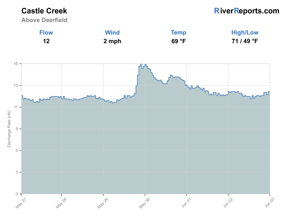
USGS data chart
Official USGS trend
Streamflow over the latest USGS reporting window.
Latest
13 cfs
Jun 3, 5 PM UTC
Weather
River weather report
Weather can change wading safety, road access, water temperature, hatches, and the best time of day to fish.
Live forecast loads as you reach this section
This keeps the report fast while still using the official National Weather Service forecast point.
Hatches and flies
Hatch chart and fly picks
March-May
Blue-winged olives, little black stones, early caddis
BWO nymph, black stonefly, tan caddis pupa
May-June
Caddis, yellow sallies, mixed mayflies
Soft hackle, hare's ear, yellow stimulator
Summer
Caddis and terrestrials
Elk hair caddis, foam ant, beetle, prince nymph
Fall
BWOs, midges, and small streamer windows
RS2, zebra midge, olive bugger
Core nymphs
Pheasant tail, hare's ear, prince, perdigon
The best default for covering short seams and depth changes without over-rigging the creek.
Dry-dropper
Yellow stimulator, parachute Adams, foam ant with a small nymph
Useful on stable flow when trout will slide into meadow edges and pocket water.
Small streamers
Olive bugger, black bugger, leech-style mini streamer
Worth trying through darker wood or when weather puts a little color in the creek.
Tactics
How to fish it
Pick one short legal corridor and fish it thoroughly before driving farther up the road.
Cover undercut meadow banks and the first soft pocket beside wood before stepping into midstream water.
If the creek is higher than expected, fish from the bank and treat the day as a seam-and-edge hunt instead of a crossing program.
The upper Castle plan works best when you are willing to leave marginal water alone and protect the next few high-quality pockets.
Rigging
Rod, leader, and setup notes
A 7 1/2- to 8 1/2-foot 3- to 5-weight fits most upper Castle Creek days.
Carry 4X through 6X tippet and only enough weight to touch the lower seam once or twice each drift.
A compact indicator or dry-dropper rig usually beats a long heavy setup on this upper water.
Sticky soles help because the meadow banks and shallow rock shelves get slick quickly after afternoon showers.
Access
Access and planning notes
Above-Deerfield gauge
Primary upper-creek trendWade / float / trail
RiverReports / USGS gauge / wade
When to pick it
Start here when storm response, temperature, and creek size decide whether to go.
Caution
The gauge does not confirm road condition, campsite availability, or every pull-off's legal status.
Forest Service Road 291 corridor
Main upper-creek access spineWade / float / trail
Forest road / short wade
When to pick it
Use it when you want the most source-supported upper Castle Creek plan.
Caution
Stay on public road access and avoid guessing at unsigned bends or private edges.
Castle Peak and Deerfield context
Public-land backupWade / float / trail
Campground / reservoir-area planning
When to pick it
Pick this when the day needs a simple public base rather than several uncertain pull-offs.
Caution
Campground and road status can change with weather, season, and local closures.
Stay on signed public access and established National Forest roads.
This creek is better fished as a handful of short, legal stops than as a long wandering vehicle tour.
If you cannot confirm public access from the road or right-of-way, skip that bend and keep moving.
Regulations
Check before fishing
South Dakota trout rules can include Black Hills exceptions. Recheck the 2026 South Dakota Fishing Handbook and current state regulations before fishing upper Castle Creek.
Primary base
Hill City, Deerfield Road, or a Black Hills day built around the Deerfield Reservoir complex
Best day style
Road-linked upper-creek trout water with short public pull-offs, meadow edges, and limited crossing margin
Check first
RiverReports, USGS 06409000, Forest Service Road 291 access, South Dakota trout regulations, and the NWS forecast
Safety
Cold current, slick meadow banks, quick thunderstorms, remote pull-offs, and warm-season trout handling
Gear
Helpful gear for this water
3- to 5-weight rod
A good fit for short nymph drifts, dry-droppers, and small streamers on upper Black Hills water.
Compact day pack
Useful for layers, water, and a handful of short road-linked stops.
Thermometer
Worth carrying when sunny low-water afternoons change the trout-handling decision.
Rain shell
Upper Black Hills weather can shift quickly even on modest half-day plans.
Nearby water
Other water to research
Backup logic
High or stained water
Compare Castle Creek Below Deerfield or Rapid Creek before forcing a small muddy creek.
Warm trout conditions
Fish early, move to colder water, or stop trout fishing for the day.
Road or access uncertainty
Use a clearer public corridor below Deerfield or on Rapid Creek.
Crowded short water
Shift timing or move to French Creek or another Black Hills route.
Castle Creek Below Deerfield
The better backup when you want a clearer walk-in corridor and more concentrated below-dam trout habitat.
Rapid Creek
A stronger choice when you want more public mileage and a bigger-corridor trout day.
French Creek
A more committing natural-area option when you want a different drainage and can accept harder crossings.
FAQ
Fast answers
Is Castle Creek fishable today?
Castle Creek looks very fishable right now. The live score is 96/100, based on current flow, weather, public alerts, and the report's planning context. Recheck the linked gauge and forecast before leaving because conditions can change quickly after rain, heat, access changes, or flow swings.
What flow is best for Castle Creek?
Use the above-Deerfield trend with weather and temperature. Stable cool water is the cleanest small-creek signal.
When should I skip Castle Creek?
Skip when thunderstorms are active, the creek is rising or stained, water is warm, banks are slick, or public access is not confirmed.
Is Castle Creek safe to wade right now?
The fishability score is not a wading guarantee. Wade only where your chosen access has safe edges, clear footing, legal entry, and no forced crossings; high, rising, stained, or storm-affected water should be treated conservatively.
What flow should I check for upper Castle Creek?
Use RiverReports for the live chart and keep USGS site 06409000 open as the official above-Deerfield reference.
Where is the best public access above Deerfield Reservoir?
Start with the Forest Service Road 291 corridor because South Dakota's stream-management plan specifically identifies that road as the upper Castle Creek access route.
How is upper Castle Creek different from below Deerfield?
Above the reservoir you are planning a smaller road-linked upper creek day. Below Deerfield the trout habitat is more reservoir-influenced and the public corridor is more walk-in oriented.
Sources
Source set for this report
Reviewed 2026-06-02