
Oregon / West
Deschutes River Middle
A Middle Deschutes report for Bend-to-Culver canyon water, wild trout, public/private access cautions, flow checks, flies, and regulations.
Image: Generated regional planning image for Deschutes River Middle / BlueStreamFly generated; not exact location / BlueStreamFlyFishability now: Deschutes River Middle fishability today
GreatData confidence: High96/100
Fishable now because the live gauge is stable, weather is mild, and no public alert is active.
Flow observed
5:00 PM UTC
Weather observed
5:00 PM UTC
Score calculated
5:24 PM UTC
Why this rating
Flow
Water temperature
Public alerts
Next 6-12 hours
Hold
Stable live data supports staying with the plan, but recheck the gauge and forecast before leaving.
USGS flow
551 cfs
Current trend: flow stable, so weather, temperature, and access checks drive the next change.
More planning details: flies, flow bands, and live source checks
Fish it today
Start here
Start with known public access around Terrebonne, Steelhead Falls, or other BLM-managed middle-river entries, then fish one canyon section thoroughly. This water rewards commitment to a smaller legal corridor more than it rewards trying to sample too many unknown pullouts.
Best flow clue
Use RiverReports near Culver with the Culver and Bend USGS gauges as broad trend context. The best windows are steady flows that let you read pockets and banks safely; abrupt irrigation changes, canyon heat, or uncertain side-channel depth should push the day toward conservative access or another river.
Skip trigger
Skip the trip when you cannot verify the legal public entry, when canyon heat makes the hike out the hardest part of the day, or when the gauge trend is too broad to support a confident first visit.
Flow decision bands
Low but still workable
Steady lower-middle canyon flow can still fish well, but the best day usually comes from committing to one legal pocket-water section instead of chasing every visible bend.
Best steady canyon trend
A stable Culver trend with manageable weather is the cleanest signal for a wade-first Middle Deschutes trout day.
Hot hike-out or unstable water
If the canyon is already hot, the walk out feels like the hardest part of the day, or the broad trend is changing too quickly, shorten the plan or choose a simpler river.
Public-entry uncertainty
A fishable trend still is not enough when the legal access point, private boundary, or safe turnaround plan is not fully clear before you hike in.
USGS flow
551 cfs
Current trend: flow stable, so weather, temperature, and access checks drive the next change.
Live USGS flow
548 cfs / stable
Live NWS forecast
65F / Partly Sunny
Live water temperature
57F from USGS
No NWS alert flag
No active NWS alert was returned for this forecast point.
Use the Culver gauge and RiverReports as a middle-canyon flow reference.
Expect wild rainbow/redband trout, brown trout in some reaches, whitefish, and bull trout context below Steelhead Falls.
Check public/private boundaries before walking down a canyon track.
Fish nymphs, dry-droppers, and streamers around pocket water and structure.
Editorial review
How this report is maintained
This report is maintained from current regulation, access, flow, weather, and public planning sources so anglers can make better trip decisions than a raw gauge or generic overview would allow.
Byline
BlueStreamFly editorial team
Reviewed by
BlueStreamFly source review
Maintained by
Mountain Brook Run LLC
Last material review
2026-06-01
Report confidence
Good confidence
86/100
Good confidence: Oregon regulation sources, BLM access guidance, RiverReports and USGS trend support, and weather coverage support the page. Confidence is moderated by mixed public and private land, steep access, and the limits of one broad gauge trend for the whole canyon.
Regulations
Oregon regulations, updates, and Central Zone context support the current middle-river rule-check path.
Access
The BLM middle-river page supports the public framework, but private-land boundaries and canyon exits still require exact trip-day judgment.
Flow and weather
RiverReports near Culver, the Culver and Bend USGS gauges, and the National Weather Service point provide a strong live planning set for trend and canyon-weather decisions.
Fishing usefulness
The page now separates legal-entry checks, wade-first canyon planning, hot hike-out caution, and simpler backup-water choices.
Fishability dashboard and source review
2026-06-01 / material content or source review
Middle Deschutes rules and updates, the Central Zone report, the BLM middle-river access page, RiverReports near Culver, the Culver and Bend USGS gauges, and the National Weather Service point were checked before updating the current-fishability decision layer.
2026-06-01
Updated Deschutes River Middle to the current fishability-page standard with canyon flow bands, access cards, backup cues, stable fishability SEO, and confidence signals.
2026-05-28
Added canyon access triage, private-land skip cues, wade-first planning guidance, imperfect-gauge context, and a page-specific report-confidence meter after source review.
2026-05-25
Initial source-reviewed report published with flows, weather, hatches, flies, tactics, access, regulations, and FAQs.
Angler planning edge
Local details that change the plan
Best for
Canyon trout anglers willing to solve access first and fish second, Trips built around pocket water, dry-droppers, and compact nymph rigs instead of a large float-water day, People comparing a more technical public and private boundary puzzle against easier tailwater options nearby, Cooler-season scouting days when stable flows make steep access and longer walks worthwhile
Wade or float
Treat the middle river as a wade-first page. The value here is in picking the right pocket-water corridor and accessing it legally, not in assuming you can float or cover the whole canyon casually.
Best flows
Use RiverReports near Culver with the Culver and Bend USGS gauges as broad trend context. The best windows are steady flows that let you read pockets and banks safely; abrupt irrigation changes, canyon heat, or uncertain side-channel depth should push the day toward conservative access or another river.
When to skip
Skip the trip when you cannot verify the legal public entry, when canyon heat makes the hike out the hardest part of the day, or when the gauge trend is too broad to support a confident first visit.
Local plan
Start with known public access around Terrebonne, Steelhead Falls, or other BLM-managed middle-river entries, then fish one canyon section thoroughly. This water rewards commitment to a smaller legal corridor more than it rewards trying to sample too many unknown pullouts.
Pressure
Easier public entries and well-known views gather the most foot traffic. Walking farther from the first access, especially on weekdays, usually matters more here than changing flies every twenty minutes.
Access nuance
Public and private land intermix enough on the middle river that the best-looking water is not always the best legal option. The BLM framework is helpful, but exact boundaries, steep exits, and realistic turnaround points still matter more than a broad map pin.
Backup water
If middle-river access feels too uncertain, pivot to the Crooked for a simpler tailwater wade day or to the Metolius for a clearer public trout plan with less private-land ambiguity.
About the river
Setting, character, and why it fishes the way it does.
The Middle Deschutes links Bend-area water to the canyon country above Lake Billy Chinook. It has a different feel than the lower river: more access puzzles, pocket water, and wild trout decisions.
Irrigation-season changes, springs, canyon shade, and private land all affect the fishing plan. A single gauge cannot explain every pocket, so use flow as a broad trend and then verify conditions on foot.
This report is scoped to the middle canyon around Bend, Terrebonne, and Culver. It keeps the lower redside and steelhead fishery on the separate Deschutes River report.
Target species
Redband rainbow trout
Primary wild trout target in riffles, pockets, and seams.
Brown trout
Structure-oriented fish in some middle-river reaches.
Mountain whitefish
Common in subsurface lanes and useful for reading nymph depth.
Bull trout
Present in parts of the system; know identification and handling rules.
Reading the water
Stable flow
Best window for exploring pocket water and dry-dropper seams.
Irrigation shifts
Expect changing depths and side-channel behavior; verify on site.
Low and clear
Use stealth, smaller dries, and careful canyon approaches.
Hot weather
Fish early and stop if trout are stressed.
Best seasons
Spring
Opening windows, BWOs, caddis, and nymphing improve with stable flows.
Summer
Early and late sessions with dry-droppers and terrestrials can work if water is safe.
Fall
Cooling water, BWOs, and streamer edges improve.
Winter
Nymphing can work where access and rules allow.
Preferred flow source
Deschutes River near Culver
RiverReports is the preferred chart source when coverage exists. When a matching USGS gauge exists, keep it open as the official backstop for station data and current hydrograph context.
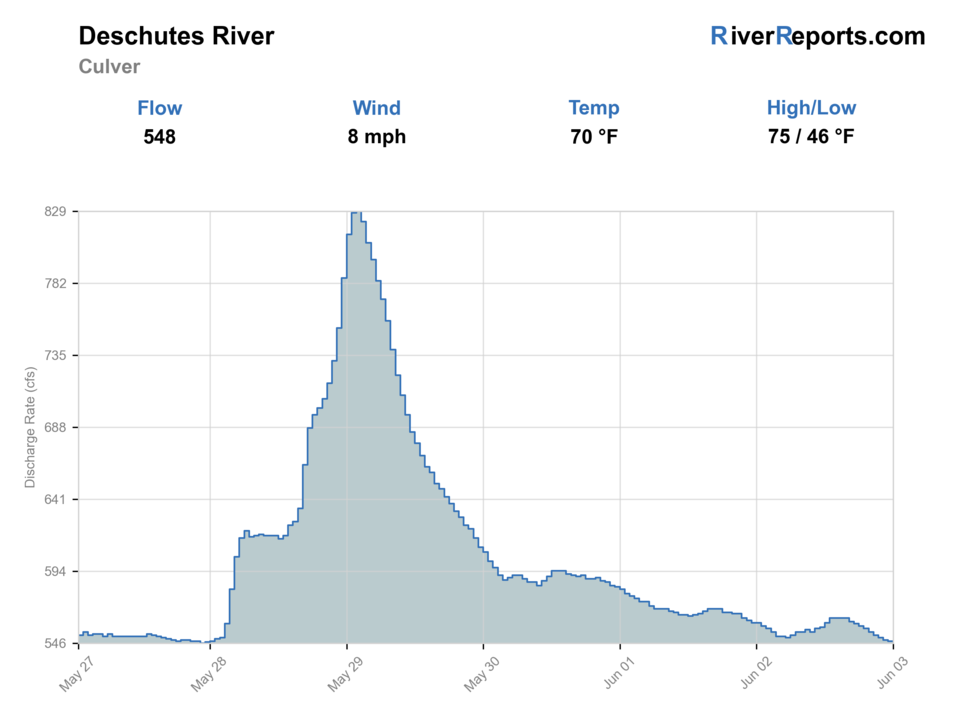
USGS data chart
Official USGS trend
Streamflow over the latest USGS reporting window.
Latest
551 cfs
Jun 3, 3 PM UTC
Weather
River weather report
Weather can change wading safety, road access, water temperature, hatches, and the best time of day to fish.
Live forecast loads as you reach this section
This keeps the report fast while still using the official National Weather Service forecast point.
Hatches and flies
Hatch chart and fly picks
Winter to early spring
Midges, BWOs, small black stones, and slow-water nymph windows
Zebra midge, BWO emerger, black stonefly nymph, perdigon, small leech
Late spring
PMDs, caddis, March Browns, Green Drakes where present, and stonefly nymph movement
PMD emerger, caddis pupa, March Brown, Green Drake, golden stone nymph
Summer
Caddis, PMDs, terrestrials, craneflies, and early/late dry-fly windows
Elk hair caddis, PMD cripple, ant, beetle, small hopper, dry-dropper
Fall
BWOs, October caddis, midges, streamer windows, and cooling-water trout activity
BWO emerger, October caddis, soft hackle, small streamer, sculpin
Nymphs
Perdigon, pheasant tail, hare's ear, zebra midge, stonefly
Use before hatches, in pocket water, or when fish are not showing on top.
Dries
BWO, PMD, caddis, Green Drake, ant, beetle, small hopper
Use during visible hatches, evening rise windows, or clear low water.
Streamers
Sculpin, leech, olive bugger, small baitfish, soft hackle streamer
Use on higher flows, cloudy days, and structure-focused trout water.
Tactics
How to fish it
Plan the access first; do not cross private land to reach a promising bend.
Nymph pocket water and ledge edges with compact rigs.
Use dry-droppers along banks and softer seams in low light.
Swing or strip small streamers around brown-trout structure when flows are safe.
Carry enough water and sun protection for canyon exits.
Rigging
Rod, leader, and setup notes
A 4 or 5-weight is enough for most middle-river trout days.
Use short dry-dropper rigs in pocket water and longer leaders in clear flats.
Carry 4X through 6X, small tungsten nymphs, and a few streamers.
Good boots and a wading staff matter more than a giant fly box.
Access
Access and planning notes
Culver and Bend trend check
Primary canyon decisionWade / float / trail
RiverReports / USGS stack
When to pick it
Start here when you need the broadest read on whether the middle canyon should stay a technical trout plan at all.
Caution
The gauge stack is useful, but one trend still cannot describe every side channel or pocket in the canyon.
BLM middle-river public entries
Named legal access startWade / float / trail
Walk-and-wade / trail access
When to pick it
Use this when you want a clearly supported public entry such as the Terrebonne or Steelhead Falls corridor instead of guessing through mixed land ownership.
Caution
Public framework helps, but steep exits and private-boundary mistakes still turn a fishable day into a bad one quickly.
One-canyon-section commitment
Practical trout planWade / float / trail
Short hike / deliberate wade
When to pick it
Pick one legal corridor and fish it thoroughly when the middle river is fishable but access and hiking effort matter more than covering miles.
Caution
Do not build the day around sampling too many unknown pullouts when the best fishability answer is already a smaller legal section.
BLM middle-river information warns that public and private lands are intermingled.
Some canyon routes are steep and hot; carry water and do not rely on cell service.
ODFW rules differ by Deschutes reach, so read the exact reach before fishing.
Regulations
Check before fishing
Confirm ODFW Central Zone rules for the exact middle-river reach. Do not apply lower-Deschutes steelhead rules to this page.
Primary base
Bend, Redmond, Terrebonne, or Culver
Best day style
Trail, canyon, bridge, BLM, and mixed public/private access
Check first
Culver flow, ODFW reach rules, private-property boundaries, fire restrictions, and weather
Safety
Canyon access, private land, rattlesnakes, heat, steep banks, and imperfect gauge coverage
Gear
Helpful gear for this water
Four or five-weight rod
Covers most trout dry-fly, nymph, and dry-dropper work.
Six-weight or streamer rod
Useful where wind, higher flows, or larger fish are realistic.
Thermometer
Important for tailwaters, summer trout, and catch-and-release decisions.
Wading staff
Useful on boulder, canyon, or slick tailwater sections.
Barbless-hook box
Many managed western waters require or strongly reward quick, low-impact handling.
Nearby water
Other water to research
Backup logic
Access uncertainty
Switch to the Crooked or Metolius instead of forcing the middle canyon without a clean public-entry plan.
Heat
Fish only the cooler part of the day and stop stretching the hike once summer heat becomes the real limit.
Broad trend change
Treat abrupt irrigation or weather-driven changes as a reason to stay conservative or pick a simpler flow read.
Crowding or steep exit risk
Use another public entry or another river rather than piling into the first easy overlook or forcing a bad climb out.
Crooked River
A more access-friendly tailwater trout option.
Deschutes River
The larger lower-river redband and steelhead report.
Metolius River
A spring-fed technical trout alternative.
FAQ
Fast answers
Is Deschutes River Middle fishable today?
Deschutes River Middle looks very fishable right now. The live score is 96/100, based on current flow, weather, public alerts, and the report's planning context. Recheck the linked gauge and forecast before leaving because conditions can change quickly after rain, heat, access changes, or flow swings.
What flow is best for Deschutes River Middle?
Use RiverReports near Culver with the Culver and Bend USGS gauges as broad trend context. The best windows are steady flows that let you read pockets and banks safely; abrupt irrigation changes, canyon heat, or uncertain side-channel depth should push the day toward conservative access or another river.
When should I skip Deschutes River Middle?
Skip the trip when you cannot verify the legal public entry, when canyon heat makes the hike out the hardest part of the day, or when the gauge trend is too broad to support a confident first visit.
Is Deschutes River Middle safe to wade right now?
The fishability score is not a wading guarantee. Wade only where your chosen access has safe edges, clear footing, legal entry, and no forced crossings; high, rising, stained, or storm-affected water should be treated conservatively.
What should I check first before fishing the Middle Deschutes?
Check the Culver flow, ODFW reach rules, private-property boundaries, heat, and BLM fire or access notices first.
Where should a first-time visitor start on the Middle Deschutes?
Start with known public access around Terrebonne, Steelhead Falls, or BLM-managed areas before exploring farther.
Can I wade the Middle Deschutes?
Yes in selected pockets at moderate flows, but steep access, private land, and heat can make a wade plan unsafe.
What flies should I bring for the Middle Deschutes?
Bring the seasonal fly box, a few backup nymphs or streamers, and enough tippet to change tactics when flow, clarity, temperature, or crowds change.
Sources
Source set for this report
Reviewed 2026-06-01