
Oregon / West
Deschutes River
A Lower Deschutes report for redside trout, summer steelhead, canyon access, boater-pass planning, hatches, flow checks, and safety.
Image: Deschutes River Trail to Benham Falls, Oregon (2014) - 22 / CC BY-SA 4.0 / Another BelieverFishability now: Deschutes River fishability today
GreatData confidence: High96/100
Fishable now because Moody near Biggs gauge is stable, weather is mild, and no public alert is active.
Flow observed
4:45 PM UTC
Weather observed
5:00 PM UTC
Score calculated
5:23 PM UTC
Why this rating
Flow
Water temperature
Public alerts
Next 6-12 hours
Hold
Stable live data supports staying with the plan, but recheck the gauge and forecast before leaving.
USGS flow
3,970 cfs
Current trend: flow stable, so weather, temperature, and access checks drive the next change.
More planning details: flies, flow bands, and live source checks
Fish it today
Start here
Choose the exact section first: upper lower-river access near the Warm Springs and Pelton context, a Maupin-centered day, or the lower canyon toward Moody and Biggs. Build your flies, shuttle, and walking expectations around that first decision instead of treating the whole Lower Deschutes like one beat.
Best flow clue
Use the Biggs RiverReports trend with Moody and Madras USGS context to understand how the lower river is behaving through the canyon. Stable lower-river flows with manageable wind and heat are the best fit; sharp flow changes, brutal afternoon wind, or thermal stress should shorten the day or change the reach.
Skip trigger
Skip the day when lower-canyon heat turns fish handling into the weak point, when floating-device or reach-specific rules are unclear, when wind makes safe boat control unrealistic, or when the water you really want is the smaller middle-river canyon instead.
Flow decision bands
Low but still fishable
Manageable lower-canyon flow can still fish well, but the day only stays useful when reach choice, walking distance, and the method you actually want all match the current conditions.
Best lower-canyon trend
A stable lower-river trend with workable wind and heat is the cleanest signal for a practical Lower Deschutes trout or seasonal steelhead plan.
Wind, heat, or pushy water
A fishable flow reading is not enough when boat control becomes unsafe, lower-canyon heat gets punishing, or current and bank angle turn a wade stop into a bad gamble.
Reach or rule mismatch
Skip or change the section when the access pass, method rule, tribal-boundary context, or the reach you really want is not fully sorted before leaving home.
USGS flow
3,970 cfs
Current trend: flow stable, so weather, temperature, and access checks drive the next change.
Live USGS flow
3,970 cfs / stable
Live NWS forecast
71F / Mostly Cloudy
Live water temperature
61F from USGS
No NWS alert flag
No active NWS alert was returned for this forecast point.
Use lower-river flow with Madras context when planning below Pelton influence.
Check ODFW exceptions before fishing from or near a boat.
Stoneflies, caddis, PMDs, BWOs, and October caddis shape trout tactics.
Summer steelhead timing depends on the reach, temperature, and current regulations.
Editorial review
How this report is maintained
This report is maintained from current regulation, access, flow, weather, and public planning sources so anglers can make better trip decisions than a raw gauge or generic overview would allow.
Byline
BlueStreamFly editorial team
Reviewed by
BlueStreamFly source review
Maintained by
Mountain Brook Run LLC
Last material review
2026-06-01
Report confidence
High confidence
91/100
High confidence: Oregon regulation sources, strong BLM access guidance, RiverReports plus official USGS gauge support, and weather coverage support the page. Confidence is tempered by fast-changing heat, wind, and section-specific rule details that still need trip-day confirmation.
Regulations
Oregon regulations, updates, and Central Zone context support the current lower-river rule-check path.
Access
The BLM lower-river page provides a strong public-access framework for Lower Deschutes reach planning.
Flow and weather
RiverReports Biggs, the Moody and Madras USGS gauges, and the National Weather Service point provide a strong live planning set for trend, heat, and safety decisions.
Fishing usefulness
The page now separates reach choice, float-versus-wade planning, heat and wind skips, and lower-canyon backup decisions.
Fishability dashboard and source review
2026-06-01 / material content or source review
Lower Deschutes rules and updates, the Central Zone report, the BLM lower-river access page, RiverReports at Biggs, the Moody and Madras USGS gauges, and the National Weather Service point were checked before updating the current-fishability decision layer.
2026-06-01
Updated Deschutes River to the current fishability-page standard with lower-canyon flow bands, access cards, backup cues, stable fishability SEO, and confidence signals.
2026-05-28
Added reach-fit guidance, boat-versus-wade framing, heat and wind skip cues, access nuance around lower-canyon planning, and a page-specific report-confidence meter after source review.
2026-05-25
Initial source-reviewed report published with lower-river flows, weather, hatches, flies, tactics, access, regulations, and FAQs.
Angler planning edge
Local details that change the plan
Best for
Lower-canyon redband days where you want a strong flow stack and a reach-first plan, Trips that may mix trout and seasonal steelhead context without confusing the middle river, Anglers who can decide early between a wade-focused stop and a float-based canyon day, People willing to plan around heat, wind, shuttle logistics, and reach-specific rules instead of expecting an easy roadside hatch chart
Wade or float
Treat the Lower Deschutes as a mixed wade-or-float river, with float planning often making more sense for covering big canyon water. Wade only where the current level, bank angle, and your exact reach make that choice clearly safer than forcing a broad on-foot plan.
Best flows
Use the Biggs RiverReports trend with Moody and Madras USGS context to understand how the lower river is behaving through the canyon. Stable lower-river flows with manageable wind and heat are the best fit; sharp flow changes, brutal afternoon wind, or thermal stress should shorten the day or change the reach.
When to skip
Skip the day when lower-canyon heat turns fish handling into the weak point, when floating-device or reach-specific rules are unclear, when wind makes safe boat control unrealistic, or when the water you really want is the smaller middle-river canyon instead.
Local plan
Choose the exact section first: upper lower-river access near the Warm Springs and Pelton context, a Maupin-centered day, or the lower canyon toward Moody and Biggs. Build your flies, shuttle, and walking expectations around that first decision instead of treating the whole Lower Deschutes like one beat.
Pressure
Well-known Maupin access and salmonfly-season banks see the heaviest crowding. Earlier starts, shoulder-season timing, and fishing away from the first obvious boat pullout usually produce a calmer day than chasing the most famous seam.
Access nuance
This river carries more planning weight than a map suggests. BLM access, pass needs, tribal boundaries, float rules, and seasonal method restrictions all change how much of the canyon is truly fishable for your exact day.
Backup water
If the lower canyon is too windy, too hot, or too regulation-heavy for the day you want, pivot to the Middle Deschutes for a smaller canyon trout plan or to the Metolius for a colder, more technical trout option.
About the river
Setting, character, and why it fishes the way it does.
The Lower Deschutes is one of Oregon's defining fly-fishing rivers. It cuts through desert canyon country below the Pelton Round Butte complex and eventually meets the Columbia near Biggs.
The river's native redband trout, often called redsides, are strong fish in fast current. Summer steelhead add another layer later in the year, but steelhead rules and run strength change enough that anglers need current ODFW information.
This report is scoped to the Lower Deschutes, not the Bend or middle river. It emphasizes flow, reach-specific regulations, access, heat, and practical trout and steelhead tactics.
Target species
Redband rainbow trout
The core Lower Deschutes trout target in riffles, seams, and banks.
Summer steelhead
Seasonal opportunity where legal and open; verify current rules and run status.
Mountain whitefish
Common and often active when trout are also feeding subsurface.
Chinook and coho
Present in parts of the system, but salmon rules are reach-specific and not the page's fly-fishing default.
Reading the water
Stable lower-river flow
Best all-around trout and steelhead planning condition.
Hot weather
Fish early, avoid overhandling trout, and watch thermal stress.
Wind
Use heavier nymph rigs or protected banks; casting can become the limiting factor.
Boating days
Check pass, launch, and no-angling-from-boat rules before building the day around a float.
Best seasons
Spring
Stoneflies, March Browns, caddis, and improving trout action.
Early summer
Salmonflies, Golden Stones, PMDs, and caddis can make classic dry-fly windows.
Late summer to fall
Steelhead interest rises, but heat and regulations must guide decisions.
Winter
Trout nymphing can work, but access, weather, and closures narrow the plan.
Preferred flow source
Deschutes River at Moody near Biggs
RiverReports is the preferred chart source when coverage exists. When a matching USGS gauge exists, keep it open as the official backstop for station data and current hydrograph context.
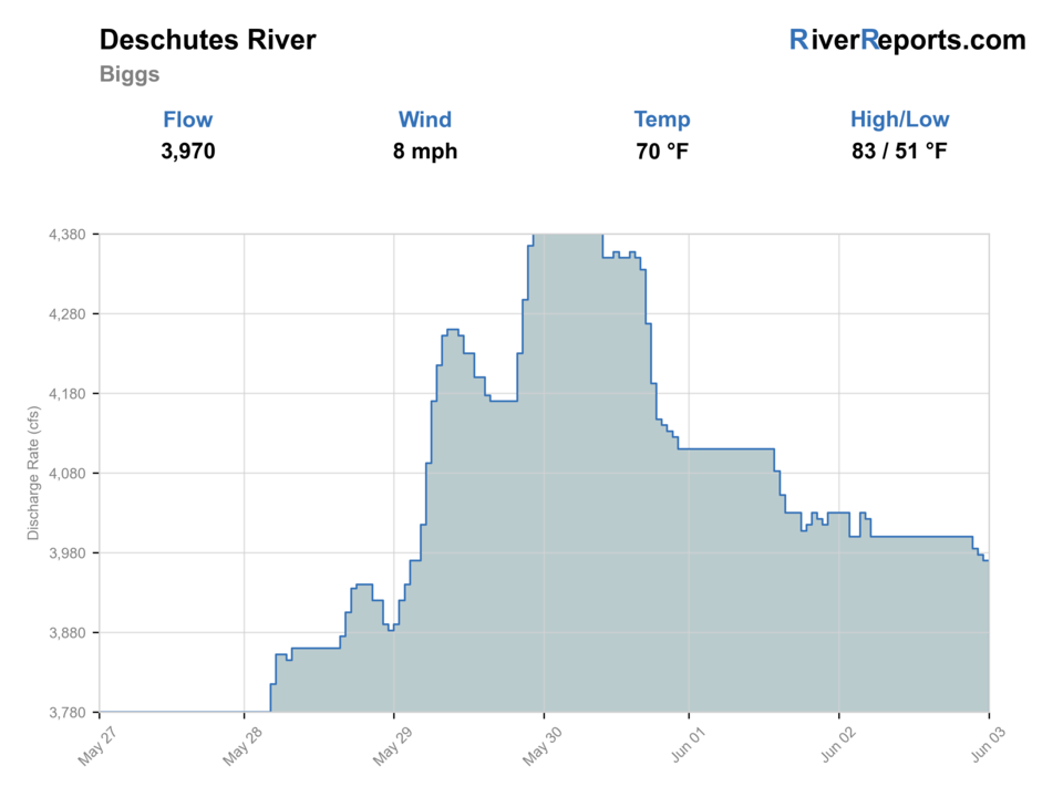
USGS data chart
Official USGS trend
Streamflow over the latest USGS reporting window.
Latest
3,970 cfs
Jun 3, 4 PM UTC
Weather
River weather report
Weather can change wading safety, road access, water temperature, hatches, and the best time of day to fish.
Live forecast loads as you reach this section
This keeps the report fast while still using the official National Weather Service forecast point.
Hatches and flies
Hatch chart and fly picks
Spring
Spring Chinook and trout context, caddis, March Browns, and variable high-water windows
Caddis pupa, March Brown, stonefly nymph, soft hackle, small streamer
Summer
Summer steelhead movement, caddis, golden stones, and early/late low-light windows
Skater, wet fly, Freight Train, Green Butt Skunk, caddis, small stonefly
Fall
Steelhead, half-pounder, October caddis, BWOs, and cooling trout water
Traditional wet fly, October caddis, BWO, small intruder, egg-sucking leech
Winter
Winter steelhead in legal reaches, cold water, high flows, and slower presentations
Sink-tip wet fly, rabbit leech, dark intruder, egg pattern, black stonefly
Nymphs
Perdigon, pheasant tail, hare's ear, zebra midge, stonefly
Use before hatches, in pocket water, or when fish are not showing on top.
Dries
BWO, PMD, caddis, Green Drake, ant, beetle, small hopper
Use during visible hatches, evening rise windows, or clear low water.
Streamers
Sculpin, leech, olive bugger, small baitfish, soft hackle streamer
Use on higher flows, cloudy days, and structure-focused trout water.
Steelhead wet flies
Green Butt Skunk, Freight Train, Muddler, small intruder
Use in legal steelhead water during low-light summer and fall windows.
Tactics
How to fish it
Pick the reach before picking flies; lower-river rules and access change by section.
Nymph heavy riffles and seams when trout are not looking up.
Fish stonefly dries or dry-droppers around banks during the big-bug window.
Swing traditional wet flies for steelhead only where current regulations and conditions support it.
In summer heat, shorten sessions and prioritize fish recovery.
Rigging
Rod, leader, and setup notes
A 5-weight covers trout; a 6-weight helps with wind and bigger dry-dropper rigs.
Use a 7 or 8-weight single-hand or light two-hand rod for steelhead.
Carry floating lines, sink tips, large stoneflies, small nymphs, and caddis dries.
Bring water, sun protection, and a wading staff for canyon days.
Access
Access and planning notes
Biggs, Moody, and Madras trend check
Primary river-wide decisionWade / float / trail
RiverReports / USGS stack
When to pick it
Start here when you need to decide whether the lower canyon should be a float, a short wade stop, or a different river entirely.
Caution
The trend stack is strong, but it does not replace section-specific wind, shuttle, and rule checks.
Maupin and BLM lower-canyon corridor
Named public access anchorWade / float / trail
Walk-and-wade / bank / float launch
When to pick it
Use it when you want the clearest public-access framework for a lower-canyon day with known entry and exit options.
Caution
Public access still does not erase steep banks, heavy wind, or exact seasonal rule details for the section you pick.
Float-day versus wade-stop section choice
Method decisionWade / float / trail
Float / wade / shuttle plan
When to pick it
Pick this when the flow is fishable but the real question is whether the day should be one deliberate bank stop or a fully planned canyon float.
Caution
Do not let a generic Lower Deschutes label hide the difference between a short-access day and a shuttle-heavy float commitment.
BLM and Oregon State Parks access and pass rules should be checked before floating or using managed sites.
Some reaches have tribal, seasonal, or method-specific restrictions.
The canyon can be hot, windy, and remote; bring more water and time than a roadside creek requires.
Regulations
Check before fishing
ODFW Central Zone exceptions for the Lower Deschutes are reach-specific. Confirm the current rule set before fishing, especially around floating-device restrictions, steelhead, salmon, and seasonal closures.
Primary base
Maupin, Warm Springs, Madras, or The Dalles
Best day style
Canyon road, boat, trail, day-use, and permit-managed access
Check first
ODFW Central Zone rules, RiverReports/USGS flow, boater-pass rules, tribal boundaries, and heat
Safety
Big water, canyon heat, boating rules, rattlesnakes, wind, and seasonal closures
Gear
Helpful gear for this water
Four or five-weight rod
Covers most trout dry-fly, nymph, and dry-dropper work.
Six-weight or streamer rod
Useful where wind, higher flows, or larger fish are realistic.
Thermometer
Important for tailwaters, summer trout, and catch-and-release decisions.
Wading staff
Useful on boulder, canyon, or slick tailwater sections.
Barbless-hook box
Many managed western waters require or strongly reward quick, low-impact handling.
Nearby water
Other water to research
Backup logic
Wind or boat-control risk
Shorten to a bank-access stop or pivot to the Middle Deschutes or Metolius instead of forcing a bad canyon float.
Heat
Fish the cooler window only, protect fish handling, and stop stretching the day once lower-canyon heat becomes the real story.
Rule or reach confusion
Choose another clearly understood section or another river rather than improvising around access, pass, or method details.
Crowding
Move to a second named access or another river before piling onto the first obvious bank or boat pullout.
Deschutes River Middle
A Bend-to-Culver middle-river plan with different access and flow behavior.
Crooked River
A nearby smaller tailwater trout option.
Metolius River
A spring-fed technical trout alternative.
FAQ
Fast answers
Is Deschutes River fishable today?
Deschutes River looks very fishable right now. The live score is 96/100, based on current flow, weather, public alerts, and the report's planning context. Recheck the linked gauge and forecast before leaving because conditions can change quickly after rain, heat, access changes, or flow swings.
What flow is best for Deschutes River?
Use the Biggs RiverReports trend with Moody and Madras USGS context to understand how the lower river is behaving through the canyon. Stable lower-river flows with manageable wind and heat are the best fit; sharp flow changes, brutal afternoon wind, or thermal stress should shorten the day or change the reach.
When should I skip Deschutes River?
Skip the day when lower-canyon heat turns fish handling into the weak point, when floating-device or reach-specific rules are unclear, when wind makes safe boat control unrealistic, or when the water you really want is the smaller middle-river canyon instead.
Is Deschutes River safe to wade right now?
The fishability score is not a wading guarantee. Wade only where your chosen access has safe edges, clear footing, legal entry, and no forced crossings; high, rising, stained, or storm-affected water should be treated conservatively.
What should I check first before fishing the Lower Deschutes?
Check ODFW Central Zone rules, RiverReports/USGS flow, heat, wind, access pass requirements, and any tribal or seasonal restrictions first.
Where should a first-time visitor start on the Lower Deschutes?
Maupin is the easiest first base for many lower-river plans, but your exact reach should match rules and flow.
Can I wade the Lower Deschutes?
Yes in many places at the right level, but it is big, powerful canyon water. Do not wade where a slip would become a swim.
What flies should I bring for the Lower Deschutes?
Bring the seasonal fly box, a few backup nymphs or streamers, and enough tippet to change tactics when flow, clarity, temperature, or crowds change.
Sources
Source set for this report
Reviewed 2026-06-01