New York / Northeast
Salmon River
A Pulaski and Altmar report for Salmon River flows, dam-release checks, salmon and steelhead timing, access, legal cautions, and fly tactics.
Image: Salmon River Pulaski NY 20091101 / CC BY-SA 4.0 / AntepenultimateFishability now: Salmon River fishability today
GreatData confidence: High96/100
Fishable now because Pineville gauge is falling, weather is mild, and no public alert is active.
Flow observed
4:15 PM UTC
Weather observed
5:00 PM UTC
Score calculated
5:25 PM UTC
Why this rating
Flow
Weather
Public alerts
Next 6-12 hours
Improving / hold
A falling gauge and usable weather should keep the next 6-12 hours in play unless tributaries stain or heat builds.
USGS flow
295 cfs
Current trend: flow falling, rating likely holding strong unless weather or clarity changes.
More planning details: flies, flow bands, and live source checks
Fish it today
Start here
Start with Pineville flow, SafeWaters, and the DEC reach rules. Pick one style for the day: upper fly-water focus, mid-river steelhead travel lanes, lower-river run timing, or a shorter bank plan when flows are high.
Best flow clue
Use RiverReports, USGS 04250200 at Pineville, and Brookfield SafeWaters together. Stable moderate releases are the cleanest mixed-access window; high releases move the plan to bank or boat tactics, and sudden changes should stop any aggressive crossing plan.
Skip trigger
Skip or pivot when releases rise beyond your safe wading range, visibility is poor, shelf ice or cold water makes footing dangerous, crowding prevents ethical spacing, or current Great Lakes tributary rules for the exact reach are not confirmed.
Flow decision bands
Low but still fishable
Lower steady Salmon River flow can still fish well, but exact holding water, crowd spacing, and careful drift control matter more than marching through every famous run.
Best Pineville release window
Stable Pineville flow with current Brookfield release context is the cleanest signal for eggs, nymphs, swingers, and a measured tributary day.
High, pushy, or unsafe
Hard release changes, cold pushy current, shelf ice, or conditions that erase safe edge water should move the day to another access style or another river.
Crowd or rule pressure
A fishable graph still becomes a poor trip when Great Lakes tributary rules are unclear or the obvious public corridor is already overloaded.
USGS flow
295 cfs
Current trend: flow falling, rating likely holding strong unless weather or clarity changes.
Live USGS flow
295 cfs / falling about 27%
Live NWS forecast
71F / Sunny
Water temperature not verified
Heat guidance uses weather and river type unless an official water-temperature value is available.
No NWS alert flag
No active NWS alert was returned for this forecast point.
Use USGS Pineville and SafeWaters before choosing a wade, boat, or bank plan.
DEC Great Lakes tributary rules and fly-only reach rules are highly seasonal.
Fall salmon, winter steelhead, spring drop-backs, and summer smallmouth need different flies.
Expect crowds during peak runs; plan access and etiquette before you arrive.
Editorial review
How this report is maintained
This Salmon River report is maintained from RiverReports and USGS Pineville flow data, Brookfield SafeWaters release context, New York Great Lakes tributary regulations, DEC Salmon River access and public fishing rights sources, corridor background, weather, media-credit, and Lake Ontario run-fish planning sources.
Byline
BlueStreamFly editorial team
Reviewed by
BlueStreamFly source review
Maintained by
Mountain Brook Run LLC
Last material review
2026-05-31
Report confidence
High confidence
90/100
High confidence: RiverReports, USGS Pineville flow, Brookfield SafeWaters release context, DEC Salmon River access and public-rights sources, Great Lakes tributary regulations, and weather support the page. Confidence is moderated by dam-release timing, crowding, ice, and reach-specific boundary details.
Regulations
New York Great Lakes tributary regulations support current season, method, and harvest-rule checks for the Salmon corridor.
Access
DEC Salmon River access information, the public fishing rights map, and corridor guidance provide strong public-planning anchors, with exact boundaries still requiring care.
Flow and weather
RiverReports Salmon River at Pineville, USGS 04250200, Brookfield SafeWaters release context, and the National Weather Service point provide a strong live planning set.
Fishing usefulness
The page now separates release timing, run-fish access choice, crowd pressure, safe footing, and backup-water decisions.
Fishability dashboard and source review
2026-05-31 / material content or source review
RiverReports Salmon River at Pineville, USGS 04250200, Brookfield SafeWaters Lighthouse Hill release context, DEC Salmon River access information, Great Lakes tributary regulations, the Salmon River public fishing rights map, corridor guidance, and the National Weather Service point were checked before updating the current-fishability decision layer.
2026-05-31
Updated Salmon River to the current fishability-page standard with release-aware flow bands, access cards, backup cues, stable fishability SEO, and confidence signals.
2026-05-28
Added RiverReports flow coverage to the source stack, expanded release and run-timing planning, added crowd and wade-safety nuance, backup-water suggestions, editorial review signals, and a page-specific report-confidence meter after source review.
2026-05-25
Initial source-reviewed report published with Pineville flow, release checks, run timing, flies, access, regulations, weather, and FAQs.
Angler planning edge
Local details that change the plan
Best for
Lake Ontario anglers planning Chinook, coho, Atlantic salmon, steelhead, brown trout, and drop-back windows around Pineville flow and Lighthouse Hill releases, Trips where dam releases, Great Lakes tributary rules, fly-only reach boundaries, PFR access, crowds, and cold-water safety all need a direct check, Nymph, egg-pattern, swing, streamer, and controlled-depth presentations matched to run stage and legal method rules, Anglers comparing the Salmon River with Cattaraugus Creek, Chautauqua Creek, or the Saranac River before choosing a New York tributary plan
Wade or float
Treat the Salmon River as controlled wade, bank, and drift-boat water. Release level, run timing, crowd density, shelf ice, and reach rules should decide the plan before fly selection.
Best flows
Use RiverReports, USGS 04250200 at Pineville, and Brookfield SafeWaters together. Stable moderate releases are the cleanest mixed-access window; high releases move the plan to bank or boat tactics, and sudden changes should stop any aggressive crossing plan.
When to skip
Skip or pivot when releases rise beyond your safe wading range, visibility is poor, shelf ice or cold water makes footing dangerous, crowding prevents ethical spacing, or current Great Lakes tributary rules for the exact reach are not confirmed.
Local plan
Start with Pineville flow, SafeWaters, and the DEC reach rules. Pick one style for the day: upper fly-water focus, mid-river steelhead travel lanes, lower-river run timing, or a shorter bank plan when flows are high.
Pressure
Pressure can be extreme during salmon and steelhead windows. Legal parking, clean spacing, and moving away from packed pools usually matter more than chasing every visible fish.
Access nuance
DEC Salmon River and public fishing rights sources are strong planning anchors, but private or fee banks, fly-only boundaries, parking, and exact reach rules still need current confirmation.
Backup water
If the Salmon River is unsafe, crowded, or out of shape, compare Cattaraugus Creek for a Lake Erie steelhead option, Chautauqua Creek for a smaller tributary, or the Saranac River for a Lake Champlain salmon plan.
About the river
Setting, character, and why it fishes the way it does.
The Salmon River runs from Lighthouse Hill Reservoir through Altmar and Pulaski before entering Lake Ontario. DEC describes it as a major sportfish river with public fishing rights and two catch-and-release fly-fishing-only areas.
This is not a hatch-chart-only trout stream. The page has to work like a run-timing planner because Chinook, coho, Atlantic salmon, steelhead, brown trout, and smallmouth all matter in different seasons.
The most useful plan checks Pineville flow, SafeWaters releases, DEC regulations, access, and crowd pressure before picking a rig. A legal and safe presentation is more important than chasing a stale report.
Target species
Chinook salmon
Major fall run fish; timing and legal rig rules matter.
Coho salmon
Fall run fish that often mix with Chinook but can behave differently.
Steelhead
Late fall through spring target with winter holdover and spring drop-back windows.
Brown trout and Atlantic salmon
Seasonal lake-run opportunity; confirm current rules and identification.
Reading the water
Stable moderate release
Best mix of wading options, drift control, and fish movement.
High release
Bank or boat tactics are safer; avoid crossings and heavy mid-channel current.
Low clear water
Use smaller eggs, nymphs, and stealth; fish can be pressured and visible.
Winter cold
Fish slower pools, protect hands, and watch shelf ice and anchor ice.
Best seasons
Late summer and fall
Chinook, coho, Atlantic salmon, and brown trout movement define the trip.
Late fall
Steelhead follow salmon eggs and hold in travel lanes and softer edges.
Winter
Steelhead hold in deeper pools; short warm-ups can improve activity.
Spring
Spawning steelhead and drop-backs create nymph, egg, and streamer opportunities.
Preferred flow source
Salmon River at Pineville
RiverReports is the preferred chart source when coverage exists. When a matching USGS gauge exists, keep it open as the official backstop for station data and current hydrograph context.
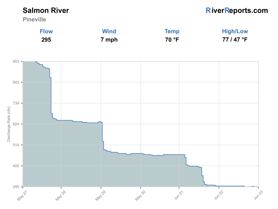
USGS data chart
Official USGS trend
Streamflow over the latest USGS reporting window.
Latest
295 cfs
Jun 3, 4 PM UTC
Weather
River weather report
Weather can change wading safety, road access, water temperature, hatches, and the best time of day to fish.
Live forecast loads as you reach this section
This keeps the report fast while still using the official National Weather Service forecast point.
Hatches and flies
Hatch chart and fly picks
Late August to October
Chinook and coho runs, salmon eggs, baitfish, and fall caddis
Egg pattern, sucker spawn, estaz egg, woolly bugger, bright streamer
November to February
Steelhead eggs, winter stoneflies, midges, and slow-water nymph food
Stonefly, zebra midge, egg pattern, hare's ear, dead-drifted streamer
March to May
Drop-back steelhead, eggs, BWOs, caddis, and small baitfish
BWO emerger, caddis pupa, egg pattern, soft hackle, olive streamer
June to August
Smallmouth forage, terrestrials, crayfish, and early Atlantic salmon context
Clouser, crayfish, popper, foam hopper, small baitfish streamer
Eggs and nymphs
Sucker spawn, single eggs, stoneflies, pheasant tails, caddis pupa
Use when steelhead are holding in pools or feeding behind spawning fish.
Streamers
Woolly bugger, zonker, leech, Clouser, small intruder
Use when the river is dropping, lightly stained, or fish are moving.
Smallmouth flies
Crayfish, baitfish, popper, slider
Use after steelhead season when warmwater fish become the better plan.
Low-clear water
Small eggs, black stoneflies, micro buggers, midge nymphs
Use long leaders, lighter tippet, and careful presentations in clear water.
Tactics
How to fish it
Check Pineville flow and SafeWaters before leaving the house.
Match tactics to run stage: moving salmon, holding steelhead, winter pools, or spring drop-backs.
Use legal fly-fishing-only and terminal-tackle rules for the exact reach and date.
Fish edges and travel lanes first at higher releases instead of forcing mid-river wades.
Give spawning fish and other anglers space; this river gets intense during peak periods.
Rigging
Rod, leader, and setup notes
A 7-weight or 8-weight single-hand rod covers most fly work.
Carry floating, indicator, and sink-tip options rather than one fixed rig.
Use tippet matched to species, clarity, and legal rules for the reach.
Bring split shot or weighted flies only where current rules allow.
A large net and traction are not optional in cold high water.
Access
Access and planning notes
Pineville gauge and release check
Primary trip decisionWade / float / trail
Gauge / scout
When to pick it
Start here when release trend and current speed decide whether the Salmon should be the main plan at all.
Caution
A good number does not remove dam-driven changes, shelf ice, or heavy angler traffic farther down the corridor.
DEC public fishing rights corridor
Core run-fish accessWade / float / trail
Walk-and-wade
When to pick it
Use it when current rules, legal access, and crowd level still support a deliberate steelhead or salmon day.
Caution
Do not assume one public-rights section solves crowding, etiquette, or every downstream boundary detail.
Lower-river and bridge-access option
Backup public reachWade / float / trail
Scout / walk-and-wade
When to pick it
Pick it when you need a second legal access plan after checking release, weather, and corridor pressure.
Caution
Current speed, boats, and exact bridge-area access still need same-day judgment.
DEC notes about 12 miles of PFR access, but not every bank is public.
Some lower-river water is private or fee-access; do not assume the whole riverbank is open.
Peak run weekends can be crowded enough that access timing is part of the fishing plan.
Regulations
Check before fishing
NYSDEC Great Lakes tributary rules, Salmon River special rules, and fly-fishing-only area rules can change by date, reach, and method. Verify before fishing.
Primary base
Pulaski, Altmar, Port Ontario, or Oswego
Best day style
PFR, fly-fishing-only reaches, public lots, drift boats, and crowded run water
Check first
Pineville flow, SafeWaters release schedule, DEC seasonal rules, crowds, and water temperature
Safety
Dam releases, cold water, shelf ice, crowds, private banks, and high-flow wading
Gear
Helpful gear for this water
7-weight or 8-weight rod
Enough backbone for salmon, steelhead, larger trout, and wind.
Large rubber net
Protects fish and speeds landing in cold water.
Studded boots
Slick shale, cobble, shelf ice, and fast edges make traction important.
Warm backup layers
Great Lakes and winter tributary weather changes quickly.
Nearby water
Other water to research
Backup logic
High release or unsafe footing
Move to another legal bank section or choose a different tributary instead of forcing a bad release window.
Crowding
Use a second public-rights reach or another river before the day turns into a shoulder-to-shoulder drift line.
Ice or storms
Treat shelf ice, wind, and rough weather as full fishability limits and simplify the plan.
Rule confusion
Treat unclear Great Lakes tributary or corridor details as a stop signal before fishing.
Cattaraugus Creek
A Lake Erie steelhead option with different flow timing.
Chautauqua Creek
A smaller New York steelhead tributary to compare.
Saranac River
A Lake Champlain salmon option with a different access and rule set.
FAQ
Fast answers
Is Salmon River fishable today?
Salmon River looks very fishable right now. The live score is 96/100, based on current flow, weather, public alerts, and the report's planning context. Recheck the linked gauge and forecast before leaving because conditions can change quickly after rain, heat, access changes, or flow swings.
What flow is best for Salmon River?
Use RiverReports, USGS 04250200 at Pineville, and Brookfield SafeWaters together. Stable moderate releases are the cleanest mixed-access window; high releases move the plan to bank or boat tactics, and sudden changes should stop any aggressive crossing plan.
When should I skip Salmon River?
Skip or pivot when releases rise beyond your safe wading range, visibility is poor, shelf ice or cold water makes footing dangerous, crowding prevents ethical spacing, or current Great Lakes tributary rules for the exact reach are not confirmed.
Is Salmon River safe to wade right now?
The fishability score is not a wading guarantee. Wade only where your chosen access has safe edges, clear footing, legal entry, and no forced crossings; high, rising, stained, or storm-affected water should be treated conservatively.
What should I check before fishing the Salmon River?
Check USGS Pineville flow, SafeWaters releases, DEC Great Lakes tributary rules, fly-only reach rules, and weather.
Are there special regulations on the Salmon River?
Yes. The Salmon River has Great Lakes tributary rules and special reach rules, including fly-fishing-only water.
Can I wade the Salmon River?
Sometimes. Moderate releases can be wadeable, but dam changes, high water, cold water, and crowds can make wading unsafe.
What flies should I bring for the Salmon River?
Bring the seasonal hatch box, a nymph box, a few streamers, and a backup plan for clear, high, warm, or crowded water.
Sources
Source set for this report
Reviewed 2026-05-31