
New Hampshire / Northeast
Pemigewasset River
A White Mountains and central New Hampshire report for anglers checking flows, access, water temperature, and trout tactics before fishing the Pemi.
Image: Generated regional planning image for Pemigewasset River / BlueStreamFly generated; not exact location / BlueStreamFlyFishability now: Pemigewasset River fishability today
GreatData confidence: High96/100
Fishable now because Woodstock gauge is falling, weather is usable, and no public alert is active.
Flow observed
4:30 PM UTC
Weather observed
5:00 PM UTC
Score calculated
5:26 PM UTC
Why this rating
Flow
Weather
Public alerts
Next 6-12 hours
Improving / hold
A falling gauge and usable weather should keep the next 6-12 hours in play unless tributaries stain or heat builds.
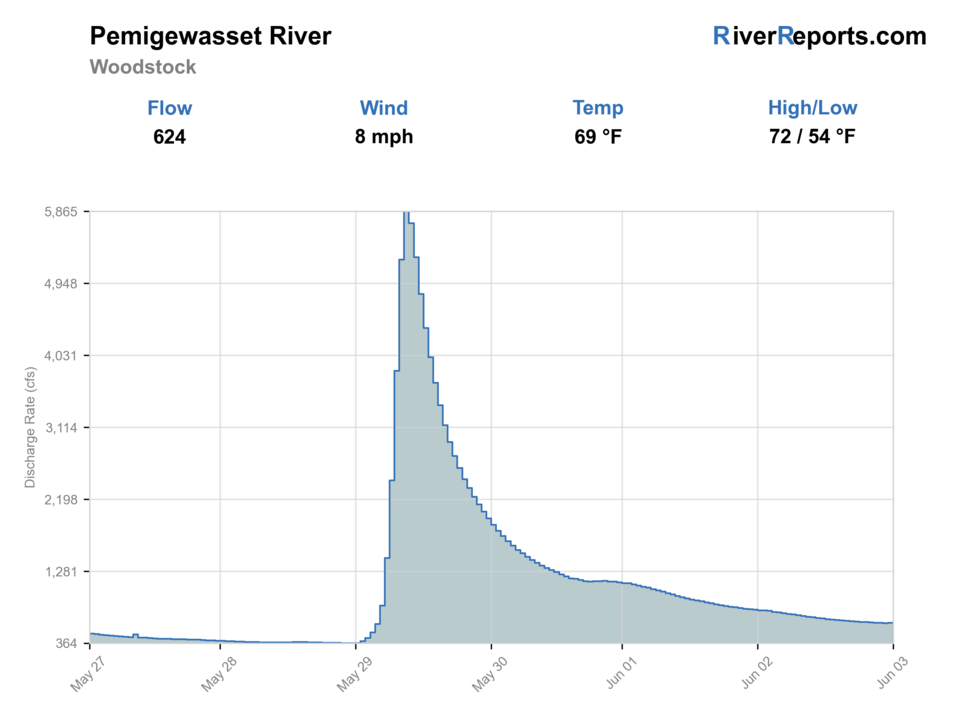
USGS flow
624 cfs
Current trend: flow falling, rating likely holding strong unless weather or clarity changes.
More planning details: flies, flow bands, and live source checks
Fish it today
Start here
Base in Lincoln, Woodstock, Plymouth, or Campton; check the gauge first, then choose upper cold-water access or lower mixed-water access.
Best flow clue
Stable or gently falling flows that leave visible edges, readable pocket water, and safe entries at public access.
Skip trigger
Skip trout fishing during rising runoff, hot low-water afternoons, thunderstorms, poor clarity, or uncertain access.
Flow decision bands
Stable clear mountain flow
Stable or gently falling Woodstock flow is the best sign that pocket water, shelves, and roadside entries can fish safely.
Rising rain or snowmelt
Rising Pemi water should move the plan away from wading and toward waiting or a smaller backup.
Low warm lower river
Low water can fish early in colder reaches, but trout-safe temperature and handling should control the day.
Stained but falling
Falling stained water can fit small streamers and larger nymphs tight to softer banks if wading stays safe.
USGS flow
624 cfs
Current trend: flow falling, rating likely holding strong unless weather or clarity changes.
Live USGS flow
624 cfs / falling about 39%
Live NWS forecast
74F / Sunny
Water temperature not verified
Heat guidance uses weather and river type unless an official water-temperature value is available.
No NWS alert flag
No active NWS alert was returned for this forecast point.
RiverReports is the quick flow view, backed by USGS 01075000 Pemigewasset River at Woodstock, New Hampshire.
White Mountain National Forest access is useful for upper-valley planning, but individual sites have their own hours, fees, and facility limits.
Check New Hampshire Fish and Game rules before fishing, especially if you are planning around trout water, bait rules, or seasonal harvest.
Warm afternoons, high runoff, and stained water can turn a good-looking river into a better scouting day than fishing day.
Editorial review
How this report is maintained
This report starts with official regulation, access, flow, weather, and public-land sources, then adds practical planning guidance for fly anglers.
Byline
BlueStreamFly editorial desk
Reviewed by
BlueStreamFly source review
Maintained by
BlueStreamFly
Last material review
2026-06-02
Report confidence
Good confidence
89/100
Good confidence: RiverReports, USGS 01075000 at Woodstock, New Hampshire Fish and Game rules, White Mountain National Forest access sources, weather coverage, generated media disclosure, and route-specific Pemi guidance support the page. Confidence is moderated by quick rain and snowmelt changes, lower-river temperature differences, exact access status, slick ledge, and reach choice.
Regulations
New Hampshire Fish and Game sources support current freshwater rule checks.
Access
White Mountain National Forest and Campton access sources support public access planning, while site status and local parking remain day-specific.
Flow and weather
RiverReports, USGS 01075000 at Woodstock, and the National Weather Service point support live flow and weather decisions.
Fishing usefulness
The page now separates Woodstock flow, upper cold-water choices, lower mixed-water context, runoff skips, warm-water stops, access checks, and White Mountains backups.
Fishability dashboard and source review
2026-06-02 / material content or source review
RiverReports and USGS 01075000 Woodstock flow, New Hampshire Fish and Game rules, White Mountain National Forest Pemigewasset District and Campton access pages, National Weather Service data, and route-specific rain, snowmelt, and warm-water guidance were checked before updating the current-fishability decision layer.
2026-06-02
Updated the Pemigewasset River with White Mountains flow bands, access cards, backup cues, and confidence signals.
2026-05-26
Published a new Pemigewasset River report with flow-first planning, White Mountains access notes, hatches, tactics, and safety guidance.
Angler planning edge
Local details that change the plan
Best for
White Mountains trout planning, Roadside pocket-water sessions, Flow-based day decisions
Wade or float
Wade planning is most common for this report. Treat high water as a no-wade condition and choose another reach or day.
Best flows
Stable or gently falling flows that leave visible edges, readable pocket water, and safe entries at public access.
When to skip
Skip trout fishing during rising runoff, hot low-water afternoons, thunderstorms, poor clarity, or uncertain access.
Local plan
Base in Lincoln, Woodstock, Plymouth, or Campton; check the gauge first, then choose upper cold-water access or lower mixed-water access.
Pressure
Weekends and easy road pullouts can be busy. Move away from obvious bridge pools and fish shorter pockets carefully.
Access nuance
National Forest and town access are useful, but posted site rules, parking, and seasonal service details still control the day.
Backup water
Saco River, Merrimack River, and Androscoggin River pages give nearby alternatives when the Pemi is high, warm, or crowded.
About the river
Setting, character, and why it fishes the way it does.
The Pemigewasset River drains a large White Mountains watershed before joining the Winnipesaukee River to form the Merrimack. That gives it a mix of mountain water, valley towns, road access, and quick weather-driven changes.
For fly anglers, the river is less about one famous pool and more about choosing the right reach for the day: upper cold-water runs, roadside pocket water, lower mixed-water stretches, or a tributary backup when the main stem is too high.
The Pemi's logging, rail, and recreation history also matters on the water. Many modern access points follow old travel corridors, while the surrounding national forest keeps a large part of the watershed tied to public recreation and cold-water habitat.
Target species
Brook trout
Most relevant in colder upper river and tributary-influenced water.
Brown trout
A practical target in suitable main-stem reaches, especially during low light and stable water.
Rainbow trout
Present in New Hampshire trout planning; verify current rules and stocking context before harvest assumptions.
Smallmouth bass
More relevant in warmer lower-river water and late-summer planning.
Reading the water
Clear and stable
Best for dry-dropper fishing, light nymphing, and careful pocket-water work.
Rising after rain
Skip wading and wait. The river can gain speed faster than it looks from the road.
Low summer water
Fish early, carry a thermometer, and move away from stressed trout.
Stained but falling
Use larger nymphs or small streamers tight to softer banks and seams.
Best seasons
Spring
Strong but changeable. Watch snowmelt, rain, and water clarity before committing.
Early summer
Often the most balanced window for hatches, access, and trout-friendly temperatures.
Late summer
Shift to mornings, shaded water, tributary influence, or warmwater targets when needed.
Fall
Good low-light streamer and nymph windows when flows are stable and rules allow.
Preferred flow source
Pemigewasset River at Woodstock
RiverReports is the preferred chart source when coverage exists. When a matching USGS gauge exists, keep it open as the official backstop for station data and current hydrograph context.
USGS data chart
Official USGS trend
Streamflow over the latest USGS reporting window.
Latest
624 cfs
Jun 3, 4 PM UTC
Weather
River weather report
Weather can change wading safety, road access, water temperature, hatches, and the best time of day to fish.
Live forecast loads as you reach this section
This keeps the report fast while still using the official National Weather Service forecast point.
Hatches and flies
Hatch chart and fly picks
April-May
Midges, early mayflies, stoneflies
Zebra midge, pheasant tail, prince nymph, small black stone
May-June
Caddis, Hendrickson-style mayflies, March brown-style mayflies
Elk hair caddis, soft hackle, parachute Adams, hare's ear
July-August
Caddis, small mayflies, terrestrials
Foam ant, beetle, X-caddis, light dropper nymph
September-October
Caddis, BWOs, midges
BWO emerger, soft hackle, small olive bugger
Pocket-water nymphs
Hare's ear, pheasant tail, prince, perdigon
Flows are clear enough to read slots but too fast for steady dry-fly work.
Dry flies
Elk hair caddis, parachute Adams, stimulator, beetle
Trout are looking up in broken water or along shaded banks.
Small streamers
Olive bugger, black bugger, small sculpin
The river is slightly stained, falling, or fishing best during low light.
Tactics
How to fish it
Start with the Woodstock gauge, then match the reach to the flow. Big water near town and smaller upper water fish very differently.
In broken pocket water, fish short drifts and move often. One careful cast to each soft edge beats long blind casting.
In low summer water, fish early or switch targets rather than grinding on warm trout.
Keep a backup plan. Nearby White Mountains water can fish better than the main stem after storms.
Rigging
Rod, leader, and setup notes
A 4- or 5-weight rod covers most dry-dropper, nymph, and light streamer work.
Carry 4X through 6X tippet for dries and small nymphs, plus 3X for streamers in stained water.
Use a short indicator or dry-dropper rig in broken water so you can adjust depth quickly.
A thermometer, wading staff, and traction matter after rain, during snowmelt, and on slick ledge.
Access
Access and planning notes
Woodstock and Lincoln area
Primary gauge-area startWade / float / trail
Town / roadside / walk-wade
When to pick it
Start here when the gauge, weather, and visible clarity support a short wade plan.
Caution
Bridge views can underestimate slick ledge and pushy current after rain.
White Mountain National Forest corridor
Upper cold-water accessWade / float / trail
National forest / roadside
When to pick it
Use it when upper cold-water habitat, legal parking, and flow make more sense than lower valley water.
Caution
Site hours, fees, seasonal service, and posted access still matter.
Campton area
Lower-valley comparisonWade / float / trail
Day-use / roadside planning
When to pick it
Pick it when the lower river has safe flow and a realistic mixed-water plan.
Caution
Warm lower-river conditions can make trout expectations weaker than the gauge suggests.
Public-looking water is not always public access. Use signed access, public land, or clear permission.
National Forest sites can be excellent bases, but some are day-use only or have seasonal service limits.
High flows can make easy-looking crossings unsafe. Do not use summer low-water routes as your plan after storms.
Regulations
Check before fishing
Confirm current New Hampshire Fish and Game freshwater rules before fishing. This page is a planning aid, not a substitute for the current regulation digest, posted access rules, or emergency updates.
Primary base
Lincoln, Woodstock, Plymouth, or Campton
Best day style
Roadside, town, and White Mountain National Forest access with conservative wading after rain or snowmelt
Check first
RiverReports, USGS 01075000, National Weather Service forecast, NH fishing rules, and posted access
Safety
Fast runoff, slick ledge, thunderstorms, warm-water trout stress, and public-access boundaries
Gear
Helpful gear for this water
4- or 5-weight rod
Enough for dries, dry-droppers, nymphs, and small streamers.
Wading staff
Useful on slick rock and during flow changes.
Thermometer
Helps decide when to stop trout fishing in warm conditions.
Rain shell
White Mountains weather can change fast even on a mild valley day.
Nearby water
Other water to research
Backup logic
Rising runoff
Move to a smaller White Mountains water or wait for the Woodstock gauge to settle.
Warm lower river
Fish upper cold-water windows only, switch targets, or choose Saco, Merrimack, or Androscoggin.
Access is unclear
Use signed public or National Forest access instead of guessing at roadside entries.
Thunderstorms
Leave the river early; the Pemi can rise and lose footing quickly.
Saco River
Another White Mountains option when you want a different flow and access pattern.
Merrimack River
The larger downstream system formed below the Pemi and Winnipesaukee confluence.
Androscoggin River
A northern New Hampshire alternative with different water size and timing.
FAQ
Fast answers
Is Pemigewasset River fishable today?
Pemigewasset River looks very fishable right now. The live score is 96/100, based on current flow, weather, public alerts, and the report's planning context. Recheck the linked gauge and forecast before leaving because conditions can change quickly after rain, heat, access changes, or flow swings.
What flow is best for Pemigewasset River?
Stable or gently falling flows that leave visible edges, readable pocket water, and safe entries at public access.
When should I skip Pemigewasset River?
Skip trout fishing during rising runoff, hot low-water afternoons, thunderstorms, poor clarity, or uncertain access.
Is Pemigewasset River safe to wade right now?
The fishability score is not a wading guarantee. Wade only where your chosen access has safe edges, clear footing, legal entry, and no forced crossings; high, rising, stained, or storm-affected water should be treated conservatively.
What gauge should I check for the Pemigewasset?
Use RiverReports for the quick chart and USGS 01075000 at Woodstock for the official gauge reference.
Is the Pemigewasset mostly a wade fishery?
Most visiting fly anglers plan around wading and roadside access, but high flows can make wading unsafe. Match your plan to the gauge and the exact reach.
When should I skip trout fishing on the Pemi?
Skip when flows are rising, water is too warm, clarity is poor, or access is unclear. A nearby smaller stream or a scouting day is often smarter.
Sources
Source set for this report
Reviewed 2026-06-02