
Montana / West
Beaverhead River at Dillon
A reach-specific Beaverhead page for anglers deciding whether the Dillon water has the flow, public access, and trout-friendly conditions for a technical brown-trout day.
Image: Generated regional planning image for Beaverhead River at Dillon / BlueStreamFly generated; not exact location / BlueStreamFlyFishability now: Beaverhead River at Dillon fishability today
GreatData confidence: High96/100
Fishable now because the live gauge is falling, weather is mild, and no public alert is active.
Flow observed
4:15 PM UTC
Weather observed
5:00 PM UTC
Score calculated
5:24 PM UTC
Why this rating
Flow
Weather
Public alerts
Next 6-12 hours
Improving / hold
A falling gauge and usable weather should keep the next 6-12 hours in play unless tributaries stain or heat builds.
USGS flow
102 cfs
Current trend: flow falling, rating likely holding strong unless weather or clarity changes.
More planning details: flies, flow bands, and live source checks
Fish it today
Start here
Start with the Dillon gauge and one named access plan such as Cornell Park or Selway Park. Fish a short technical window early, then either float legally or move upstream if the lower valley feels too warm or flat.
Best flow clue
Use RiverReports and USGS 06017000 near Dillon together. Stable moderate flow that keeps weed edges and seams defined is the best signal; dirty irrigation color, a sharp push, or hot low water should move the day.
Skip trigger
Skip or pivot when irrigation color takes over, afternoon heat makes trout handling questionable, recreation-rule timing or current restrictions do not fit the plan, or named public access is not clearly open.
Flow decision bands
Low but still technical
Lower steady Beaverhead water can still fish, but thin weed lanes, selective trout, and warm afternoons should keep the session short, careful, and temperature-aware.
Best stable weed-edge window
Stable Dillon flow with clear water and cool weather is the cleanest signal for nymphing defined seams, shelves, and weed edges before irrigation color builds.
Pushy or dirty
A flow jump, muddy irrigation push, or current that buries the soft edges should move the day upstream or onto a different river.
Heat and access caution
A fishable graph does not override hot lower-valley afternoons, seasonal recreation rules, or uncertainty around legal launch, shuttle, and parking details.
USGS flow
102 cfs
Current trend: flow falling, rating likely holding strong unless weather or clarity changes.
Live USGS flow
102 cfs / falling about 37%
Live NWS forecast
68F / Sunny
Water temperature not verified
Heat guidance uses weather and river type unless an official water-temperature value is available.
No NWS alert flag
No active NWS alert was returned for this forecast point.
Montana FWP describes the Beaverhead as a premier brown-trout river and notes seasonal recreation rules from the third Saturday in May through Labor Day.
FWP's Beaverhead drainage plan says the true tailwater runs about 16 miles below Clark Canyon Dam before Barretts Diversion Dam, while the lower river near and below Dillon is more heavily influenced by irrigation demand.
FWP's Cornell Park acquisition documents identify Cornell Park near Dillon as the only public access that allows floating to downstream Selway Park.
Use RiverReports as the quick visual chart, but keep USGS 06017000 near Dillon as the official flow reference before you commit to wading or floating.
Editorial review
How this report is maintained
This Beaverhead River at Dillon report is maintained from RiverReports and USGS Dillon flow data, Montana FWP fishing regulations, restricted-use river permit information, Beaverhead drainage planning material, Cornell Park and Selway Park access sources, stream-access law, weather, generated-image disclosure, and technical tailwater-to-valley trout planning sources.
Byline
BlueStreamFly editorial team
Reviewed by
BlueStreamFly source review
Maintained by
Mountain Brook Run LLC
Last material review
2026-05-31
Report confidence
High confidence
90/100
High confidence: RiverReports, USGS Dillon flow, Montana FWP regulations, restricted-use permit guidance, Beaverhead drainage planning material, Cornell and Selway access sources, stream-access law, weather, and generated-image disclosure are present. Confidence is moderated by irrigation color shifts, lower-valley heat, access concentration, and route-specific launch timing.
Regulations
Montana FWP regulations and restricted-use river permit guidance are linked for current Beaverhead checks.
Flow support
RiverReports Beaverhead near Dillon is backed by USGS 06017000.
Access support
Cornell Park, Selway Park, and stream-access-law sources provide concrete public-planning anchors.
Weather and safety
The National Weather Service point resolved and the page calls out lower-valley heat, irrigation color, current shifts, and launch discipline.
Angler usefulness
The page separates technical flow shape, access, heat, float versus wade choice, and backup-water decisions.
Editorial review
A public correction path, source standards page, generated-image disclosure, and public review history are included.
Fishability source review
2026-05-31 / material content or source review
RiverReports Dillon flow support, USGS 06017000, Montana FWP fishing regulations, restricted-use river permit information, Beaverhead drainage planning material, Cornell Park and Selway Park access sources, the stream-access law page, the National Weather Service point, and image disclosure were rechecked before adding the Pine Creek-standard current-fishability layer.
2026-05-31
Upgraded the page to the Pine Creek fishability standard with reviewed route profile, Dillon reach decision bands, access cards, backup logic, and a top-page current-fishability answer.
2026-05-26
Initial source-reviewed report published with Dillon reach flows, access, tactics, regulations, and FAQs.
Angler planning edge
Local details that change the plan
Best for
Dillon-area anglers planning a technical brown-trout day around steady flow, weed edges, and short public-access windows, Trips where the Dillon gauge, irrigation influence, recreation-rule timing, weather, and legal Cornell-to-Selway access all need to line up, Precise nymphing, short streamer windows, and shoulder-season or cool-summer sessions when the river still has shape, Anglers comparing the Dillon reach with the upper Beaverhead, Twin Bridges, or the Big Hole before committing to lower-valley trout water
Wade or float
Treat the Dillon reach as technical mixed wade-and-float water with a strict public-access plan. It can fish very well, but access discipline and lower-valley condition checks matter as much as fly choice.
Best flows
Use RiverReports and USGS 06017000 near Dillon together. Stable moderate flow that keeps weed edges and seams defined is the best signal; dirty irrigation color, a sharp push, or hot low water should move the day.
When to skip
Skip or pivot when irrigation color takes over, afternoon heat makes trout handling questionable, recreation-rule timing or current restrictions do not fit the plan, or named public access is not clearly open.
Local plan
Start with the Dillon gauge and one named access plan such as Cornell Park or Selway Park. Fish a short technical window early, then either float legally or move upstream if the lower valley feels too warm or flat.
Pressure
Public access points bunch anglers quickly on good flow days. Early starts and a precise plan usually matter more than trying to force an all-day marathon on the lower river.
Access nuance
Cornell Park and Selway Park are useful public anchors, but legal parking, launches, and day-of recreation rules still need exact attention. The river being public does not make every bank or turnout public.
Backup water
If Dillon is warm, dirty, crowded, or too flat, compare the upper Beaverhead for colder technical water, Twin Bridges for a float-oriented lower-river look, or the Big Hole for a different southwest Montana trout plan.
About the river
Setting, character, and why it fishes the way it does.
Montana FWP says the Beaverhead begins at Clark Canyon Dam and runs about 80 miles to the Jefferson headwaters at Twin Bridges. The Dillon page focuses on the middle-to-lower section where access and flow character change from the upper canyon tailwater.
Above town, the Beaverhead is known for dense brown-trout habitat and technical nymphing. Around Dillon, anglers still get that tight-river feel, but the reach starts to reflect irrigation demand, weed shifts, and warmer valley weather.
That makes this page best for anglers who want to decide whether Dillon is worth a dedicated stop or whether they should move upstream toward colder tailwater structure or downstream only for a float with a clear plan.
Target species
Brown trout
The primary draw and the species most closely tied to steady flows, healthy weed beds, and precise nymphing.
Rainbow trout
Present in the system, but less central to the Dillon reach identity than resident browns.
Mountain whitefish
A common indicator that the river is fishing honestly even when trout windows are selective.
Reading the water
Steady moderate flow
Best setup for technical nymphing, weed-edge drifts, and short float coverage between public access points.
Low clear flow
Fish early, get lighter, and shorten your target water to depth, weeds, and shade instead of forcing broad flats.
Irrigation push or color
Usually a sign to avoid forcing the lower reach and move to colder, cleaner water upstream.
Hot bright afternoon
The river can still look good but fish far smaller than the morning window if temperatures climb.
Best seasons
Late spring
Useful once the broader basin settles and before full summer use crowds the most obvious public access.
Summer mornings
Still productive when flows are stable, but best handled as a short technical session.
Early fall
A strong planning window when nights cool and trout use defined current again.
Late fall
Can reward patient nymphing and streamer swings if flows and weather stay stable.
Preferred flow source
Beaverhead River near Dillon
RiverReports is the preferred chart source when coverage exists. When a matching USGS gauge exists, keep it open as the official backstop for station data and current hydrograph context.
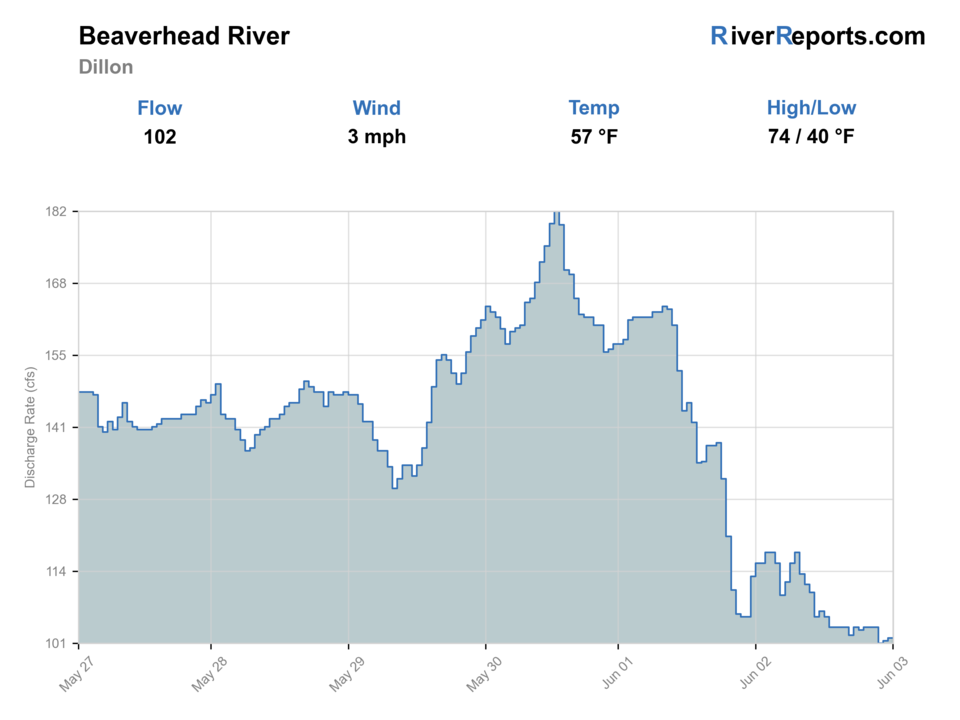
USGS data chart
Official USGS trend
Streamflow over the latest USGS reporting window.
Latest
102 cfs
Jun 3, 4 PM UTC
Weather
River weather report
Weather can change wading safety, road access, water temperature, hatches, and the best time of day to fish.
Live forecast loads as you reach this section
This keeps the report fast while still using the official National Weather Service forecast point.
Hatches and flies
Hatch chart and fly picks
Spring
Midges, BWOs, and early caddis
Zebra midge, BWO emerger, soft hackle, caddis pupa
Early summer
PMDs, caddis, yellow sallies
PMD cripple, sparkle caddis, pheasant tail, yellow sally
Summer
Tricos, caddis, terrestrials
Trico spinner, ant, hopper-dropper, caddis emerger
Fall
BWOs, midges, streamer windows
Parachute BWO, zebra midge, small sculpin, leech
Technical nymphs
Perdigon, pheasant tail, zebra midge, scud
The river has enough steadiness to reward depth control and repeated short drifts.
Dry-dropper and terrestrials
Ant, hopper, beetle, small PMD or caddis dry
Summer weed edges and banks give trout a reason to slide up.
Low-light streamers
Leech, mini sculpin, olive bugger
Cloud cover, shoulder seasons, or dirtier water call for a bigger profile.
Tactics
How to fish it
Start with the Dillon gauge, then decide whether the river still has enough shape to justify technical fishing instead of a blind confidence stop.
Fish the seams beside weed beds, cutbanks, and defined bucket water rather than trying to cover every inch of the valley channel.
If you float, keep it disciplined and centered on named public access instead of assuming convenient pull-outs are legal.
When the lower river gets warm or inconsistent, move up the drainage rather than convincing yourself the Beaverhead name will save the day.
Rigging
Rod, leader, and setup notes
A 4- to 6-weight rod with a nymphing leader covers most Beaverhead-at-Dillon days.
Carry 4X through 6X tippet because fish can be technical even when the river looks forgiving.
A compact indicator rig plus one streamer setup is a practical two-rod plan for this reach.
A thermometer matters because valley warmth can narrow the responsible fishing window faster than the water color suggests.
Access
Access and planning notes
Dillon gauge check
Primary reach decisionWade / float / trail
Gauge / wade / float
When to pick it
Start here when you need one reviewed live-flow trend before deciding whether the lower Beaverhead still has trout-water shape.
Caution
The gauge does not settle weed condition, irrigation color, or exact public access farther up and down the reach.
Cornell Park access anchor
Known public starting pointWade / float / trail
Fishing access / short wade / launch
When to pick it
Use it when you want a defensible public start before deciding whether the day is a technical wade or a Cornell-to-Selway float.
Caution
Public access here still does not make every nearby bank, field edge, or turnout a legal add-on.
Selway Park exit plan
Lower-river float finishWade / float / trail
Takeout / shuttle / short wade
When to pick it
Pick it when the river still has enough shape for a short legal float instead of trying to solve the reach through random roadside stops.
Caution
Do not force the float if wind, color, heat, or access timing strip away the trout-safe window.
Cornell Park and Selway Park are the cleanest public anchors for this reach. Build your day around them instead of ad hoc private-bank guesses.
Montana's stream-access law helps once you are lawfully on the water, but it does not create parking or bank entry where none exists.
This Dillon page is not a substitute for upper-tailwater access planning near Clark Canyon Dam or lower-river planning near Twin Bridges.
Regulations
Check before fishing
Check Montana's current fishing regulations before you fish. Use the statewide Beaverhead drainage rules along with any active drought, temperature, or recreation restrictions that Montana FWP posts during the season.
Primary base
Dillon
Best day style
Short technical wading with selective float windows between named public access points
Check first
RiverReports trend, USGS 06017000, Montana regulations and closures, and Dillon-area weather
Safety
Warm valley afternoons, slick weeded banks, irrigation-driven flow swings, and float take-out discipline
Gear
Helpful gear for this water
4- to 6-weight rod
Handles nymph rigs, small streamers, and occasional dry-dropper work.
Thermometer
Important for deciding whether the lower reach still deserves a trout-focused day.
Studded or high-grip boots
Helpful on slick weed edges, undercut banks, and muddier launch areas.
Sun and wind layer
The open valley can get bright and breezy even on modest forecast days.
Nearby water
Other water to research
Backup logic
Dirty irrigation water
Leave the Dillon reach alone when color and weak structure take over and compare colder or clearer water upstream instead of hoping the name carries the day.
Heat or restrictions
Fish only cool early windows and pivot as soon as trout-handling quality, current restrictions, or recreation rules make the lower valley a poor fit.
Crowding
Shorten the session, fish one clean seam, or move to a different reach instead of stacking another angler into the same obvious public slot.
Access issue
Use only confirmed Cornell, Selway, or other legal public access and pivot if launch, parking, or shuttle details are unclear.
Beaverhead River upper tailwater
A colder, more classic tailwater option if the Dillon section feels too warm or flat.
Beaverhead River at Twin Bridges
A lower-river float-oriented comparison farther downstream.
Big Hole River
A broader freestone pivot if the Beaverhead is crowded, colored, or too technical for the day.
FAQ
Fast answers
Is Beaverhead River at Dillon fishable today?
Beaverhead River at Dillon looks very fishable right now. The live score is 96/100, based on current flow, weather, public alerts, and the report's planning context. Recheck the linked gauge and forecast before leaving because conditions can change quickly after rain, heat, access changes, or flow swings.
What flow is best for Beaverhead River at Dillon?
Use RiverReports and USGS 06017000 near Dillon together. Stable moderate flow that keeps weed edges and seams defined is the best signal; dirty irrigation color, a sharp push, or hot low water should move the day.
When should I skip Beaverhead River at Dillon?
Skip or pivot when irrigation color takes over, afternoon heat makes trout handling questionable, recreation-rule timing or current restrictions do not fit the plan, or named public access is not clearly open.
Is Beaverhead River at Dillon safe to wade right now?
The fishability score is not a wading guarantee. Wade only where your chosen access has safe edges, clear footing, legal entry, and no forced crossings; high, rising, stained, or storm-affected water should be treated conservatively.
What should I check first on the Beaverhead at Dillon?
Start with RiverReports and USGS 06017000 near Dillon, then check current Montana regulations and any FWP closure or restriction notices.
Can I float from Cornell Park to Selway Park?
Yes, that is the main public float connection FWP identifies for this Dillon reach, but confirm current access status and low-clearance hazards before you launch.
Is this the same as the classic upper Beaverhead tailwater?
No. The Dillon reach is still technical brown-trout water, but it carries more irrigation and valley-season influence than the tighter tailwater closer to Clark Canyon Dam.
Sources
Source set for this report
Reviewed 2026-05-31