
Maine / Northeast
Penobscot River (East Branch)
A remote North Woods planning page for anglers deciding whether the East Branch Penobscot has the right flow, road conditions, and legal framework for a Grindstone-to-Lunksoos day.
Image: Generated regional planning image for Penobscot River East Branch / BlueStreamFly generated; not exact location / BlueStreamFlyFishability now: Penobscot River (East Branch) fishability today
GreatData confidence: High96/100
Fishable now because Grindstone gauge is stable, weather is usable, and no public alert is active.
Flow observed
5:00 PM UTC
Weather observed
5:00 PM UTC
Score calculated
5:26 PM UTC
Why this rating
Flow
Weather
Public alerts
Next 6-12 hours
Hold
Stable live data supports staying with the plan, but recheck the gauge and forecast before leaving.
USGS flow
1,060 cfs
Current trend: flow stable, so weather, temperature, and access checks drive the next change.
More planning details: flies, flow bands, and live source checks
Fish it today
Start here
Pick one access family such as Grindstone, Oxbow, or Lunksoos, confirm current conditions before the drive, and build the whole day around that single branch decision.
Best flow clue
Moderate readable flows that keep named access sites practical and leave enough seam structure to fish the branch cleanly.
Skip trigger
Skip when road conditions, pushy water, or weather make the access and exit margin smaller than the fishing value.
Flow decision bands
Readable remote flow
Stable or slowly falling Grindstone flow is the best sign that named access points can produce a real fishing day instead of a long scouting drive.
High pushy branch
High flow should simplify the plan to safer banks, launch checks, or a no-go if the road and exit margin shrink.
Low clear North Woods water
Low clear water can fish with stealth and lighter rigs, but only if there is enough water at the chosen access.
Road or weather problem
Remote-road conditions can make an otherwise fishable gauge the wrong call.
USGS flow
1,060 cfs
Current trend: flow stable, so weather, temperature, and access checks drive the next change.
Live USGS flow
1,060 cfs / stable
Live NWS forecast
77F / Sunny
Water temperature not verified
Heat guidance uses weather and river type unless an official water-temperature value is available.
No NWS alert flag
No active NWS alert was returned for this forecast point.
RiverReports is the working chart, backed by USGS 01029500 at Grindstone for official flow context.
Maine's special-law system treats the East Branch Penobscot as its own river entry rather than generic Penobscot coverage.
Katahdin Woods and Waters access pages, Oxbow, and Lunksoos are the clearest official public access anchors for this corridor.
This is a remote-trip river where road conditions and weather deserve the same weight as fly choice.
Editorial review
How this report is maintained
This report uses official regulation, flow, weather, access, and public-land sources first, then adds practical planning guidance for fly anglers.
Byline
BlueStreamFly editorial desk
Reviewed by
BlueStreamFly source review
Maintained by
BlueStreamFly
Last material review
2026-06-02
Report confidence
Good confidence
89/100
Good confidence: RiverReports, USGS 01029500 at Grindstone, Maine special-law sources, Katahdin Woods and Waters fishing, Oxbow, Lunksoos, and conditions sources, weather coverage, generated media disclosure, and route-specific remote-trip guidance support the page. Confidence is moderated by remote-road status, exact access choice, branch-specific rules, weather shifts, and wade-versus-launch assumptions.
Regulations
Maine special-law and fishing-law sources support current East Branch rule checks.
Access
Katahdin Woods and Waters sources support Lunksoos, Oxbow, conditions, and branch access planning.
Flow and weather
RiverReports, USGS 01029500 at Grindstone, and the National Weather Service point support live flow and weather decisions.
Fishing usefulness
The page now separates Grindstone flow, remote road status, Lunksoos and Oxbow access, special-law checks, high-water skips, and Maine backup logic.
Fishability dashboard and source review
2026-06-02 / material content or source review
RiverReports and USGS 01029500 Grindstone flow, Maine special fishing laws, Maine fishing-law hub, Katahdin Woods and Waters fishing, Oxbow, Lunksoos, and conditions pages, National Weather Service data, and route-specific remote-access guidance were checked before updating the current-fishability decision layer.
2026-06-02
Updated the East Branch Penobscot with remote-trip flow bands, Katahdin access cards, backup cues, and confidence signals.
2026-05-26
Published a new East Branch Penobscot report with branch-specific legal context, named public access anchors, and remote-trip planning guidance.
Angler planning edge
Local details that change the plan
Best for
Remote North Woods planning, Branch-specific trout and salmon days, Anglers who want a named-access and gauge-first trip plan
Wade or float
Both can work, but let the launch, road conditions, and current flow decide. This is not a river to force into one day style every trip.
Best flows
Moderate readable flows that keep named access sites practical and leave enough seam structure to fish the branch cleanly.
When to skip
Skip when road conditions, pushy water, or weather make the access and exit margin smaller than the fishing value.
Local plan
Pick one access family such as Grindstone, Oxbow, or Lunksoos, confirm current conditions before the drive, and build the whole day around that single branch decision.
Pressure
Fishing pressure is usually less about crowd density than about everyone arriving at the same few useful public access points.
Access nuance
The branch's main challenge is choosing the right official access with a realistic drive and exit plan, not simply finding blue lines on a map.
Backup water
If the East Branch turns into a road or flow problem, shift to a more road-connected Maine plan rather than trying to rescue the trip deep into the corridor.
About the river
Setting, character, and why it fishes the way it does.
The East Branch Penobscot carries a distinct North Woods identity: remote access, broad forested surroundings, and a planning style that starts with the route in and out before it starts with the cast.
Official sources split it clearly from the North Branch and the main-stem Penobscot, which matters because access, gauge context, and special-law planning are branch-specific here.
For anglers, the main challenge is not finding water. It is picking the right public entry and matching it to current flow and road conditions before the drive becomes the whole day.
Target species
Brook trout
A core East Branch draw in cold North Woods conditions and the main reason many anglers plan this branch carefully.
Landlocked salmon
A major part of the branch's reputation when flows and seasons align.
Smallmouth bass
A real lower-corridor consideration in warmer stretches and a reason to stay honest about where the day is focused.
Reading the water
Moderate readable flow
Best for combining named access points with a practical wade or boat-assisted day.
High pushy water
A sign to simplify the plan, favor safer public access, or turn the drive into a no-go.
Low clear flow
Good for careful presentations and lighter rigs, but only if you still have enough water to justify the reach you picked.
Rain-soaked road conditions
Treat access and exit risk as part of the fishing decision, not an afterthought.
Best seasons
Spring
Useful once access and flows stabilize enough to make the remote drive worthwhile.
Early summer
Often the clearest mix of flow, access, and coldwater opportunity.
Summer
Still viable on selected days, but weather and travel planning can become the limiting factors.
Fall
Strong when cooler weather sharpens the coldwater window and the road plan stays manageable.
Preferred flow source
East Branch Penobscot River at Grindstone
RiverReports is the preferred chart source when coverage exists. When a matching USGS gauge exists, keep it open as the official backstop for station data and current hydrograph context.
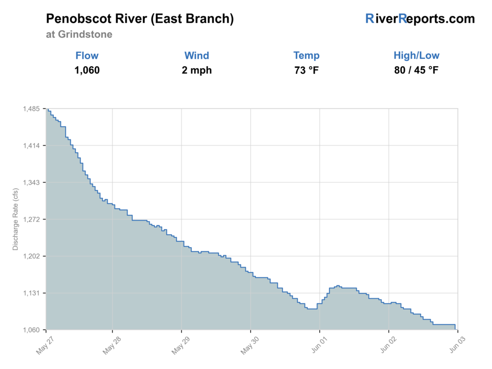
USGS data chart
Official USGS trend
Streamflow over the latest USGS reporting window.
Latest
1,060 cfs
Jun 3, 5 PM UTC
Weather
River weather report
Weather can change wading safety, road access, water temperature, hatches, and the best time of day to fish.
Live forecast loads as you reach this section
This keeps the report fast while still using the official National Weather Service forecast point.
Hatches and flies
Hatch chart and fly picks
Spring
Midges, caddis, and early mayflies
Zebra midge, caddis pupa, soft hackle, pheasant tail
Early summer
Caddis, March-brown style mayflies, and attractor windows
Elk hair caddis, March-brown style dry, hare's ear
Summer
Caddis, ants, and beetles
Caddis dry, foam ant, beetle, light nymph dropper
Fall
BWOs and streamer windows
Parachute BWO, caddis emerger, olive bugger
Coldwater nymphs
Pheasant tail, hare's ear, caddis pupa, zebra midge
The river is cool and fish are holding below obvious surface lanes.
Attractor dries
Caddis, Adams, stimulator, ant
You have readable current and enough confidence to cover bank edges and softer seams.
Streamers
Olive bugger, black bugger, slim baitfish patterns
Cloud cover, higher water, or lower-light windows call for a bigger profile.
Tactics
How to fish it
Read the Grindstone gauge and the current road or park conditions before you commit to the drive.
Start at one named access site such as Oxbow or Lunksoos and build the day from what the river actually gives you there.
On remote branches like this, a shorter well-planned session beats trying to solve every mile of water in one trip.
If the river's push or road conditions remove your clean entry or exit margin, back off early instead of improvising.
Rigging
Rod, leader, and setup notes
A 5-weight floating-line outfit covers most East Branch trout-and-salmon planning windows.
Carry longer leaders and a simple nymph rig because the branch can swing from soft visible seams to broader clear current.
Pack one light streamer option for cloud cover and higher-water days instead of hauling a separate heavy setup.
Keep spare dry layers and food in the truck because the remoteness matters more here than on near-town rivers.
Access
Access and planning notes
Lunksoos Boat Launch
Remote launch anchorWade / float / trail
NPS launch / paddle plan
When to pick it
Start here when flow, road status, and daylight support a defined East Branch launch plan.
Caution
Remote water needs an exit plan before you start fishing.
Oxbow
Access and road checkWade / float / trail
Katahdin Woods and Waters access
When to pick it
Use it when you want an official access anchor before expanding the day.
Caution
Road status and weather can matter as much as the flow number.
Grindstone corridor
Gauge-area referenceWade / float / trail
Route 170 / River Road context
When to pick it
Pick it when you want the most direct connection between the gauge and the first fishing decision.
Caution
Do not treat every remote road opening as public, practical fishing access.
The East Branch rewards named-access discipline. Use the park and regional guidance instead of assuming every roadside opening leads to a clean public entry.
Road conditions, not just water conditions, can decide whether the day is realistic.
Boat-launch and float planning should be matched to current conditions before the drive, not after arrival.
Regulations
Check before fishing
Use Maine's current special fishing laws for the East Branch Penobscot and check Katahdin Woods and Waters conditions before you fish. Branch-specific rules and access guidance matter more here than broad statewide assumptions.
Primary base
Millinocket or East Millinocket
Best day style
Boat-launch and walk-in access with remote-road planning around named North Woods sites
Check first
RiverReports trend, USGS 01029500, Maine special laws, current park or road conditions, and weather
Safety
Remote roads, fast cold water, limited services, weather shifts, and long drive consequences
Gear
Helpful gear for this water
5-weight rod
A practical default for dries, nymphs, and light streamer work on this branch.
Dry layers and food
Remote North Woods access makes self-sufficiency part of the fishing plan.
Wading staff
Useful when the branch still has push even at named public entries.
Printed access map or offline maps
Helpful when you are relying on a small set of named access points in a remote corridor.
Nearby water
Other water to research
Backup logic
Road confidence is poor
Choose a more road-connected Maine option rather than gambling the day deep in the corridor.
High branch flow
Stay bank-first, use only safer named access, or delay the East Branch trip.
Warm bright lower water
Fish cool windows for trout and salmon, or shift expectations toward appropriate species and lower-impact tactics.
Special-law uncertainty
Confirm Maine special laws before choosing flies, harvest expectations, or the exact branch reach.
Penobscot River (North Branch)
A different Penobscot branch with its own gauge and access logic; better treated as a separate trip rather than the same day.
Rapid River
A more specialized coldwater destination when you want a very different Maine trip style.
Kennebec River East Outlet
A separate salmon-and-brook-trout planning option if you want more defined release and outlet structure.
FAQ
Fast answers
Is Penobscot River (East Branch) fishable today?
Penobscot River (East Branch) looks very fishable right now. The live score is 96/100, based on current flow, weather, public alerts, and the report's planning context. Recheck the linked gauge and forecast before leaving because conditions can change quickly after rain, heat, access changes, or flow swings.
What flow is best for Penobscot River (East Branch)?
Moderate readable flows that keep named access sites practical and leave enough seam structure to fish the branch cleanly.
When should I skip Penobscot River (East Branch)?
Skip when road conditions, pushy water, or weather make the access and exit margin smaller than the fishing value.
Is Penobscot River (East Branch) safe to wade right now?
The fishability score is not a wading guarantee. Wade only where your chosen access has safe edges, clear footing, legal entry, and no forced crossings; high, rising, stained, or storm-affected water should be treated conservatively.
What should I check first on the East Branch Penobscot?
Start with RiverReports and USGS 01029500 at Grindstone, then confirm current Maine special laws and access conditions for the exact corridor you plan to use.
Is this a casual roadside trout stop?
Not really. The East Branch is a remote planning river where road conditions, named access, and exit logistics matter almost as much as the fishing itself.
Where should a first-time visitor begin?
Use one official access anchor such as Lunksoos or Oxbow and let current conditions decide whether you expand the day.
Sources
Source set for this report
Reviewed 2026-06-02