
Idaho / West
St. Joe River
A St. Joe River report for Calder flows, lower road access, upper Wild and Scenic water, cutthroat rules, hatches, dry flies, road planning, and source-checked safety.
Image: -IDAHO-B-0172- St. Joe River (28091817030) / CC BY-SA 2.0 / WaterArchives.org from Sacramento, California, USAFishability now: St. Joe River fishability today
GreatData confidence: High96/100
Fishable now because Calder gauge is falling, weather is mild, and no public alert is active.
Flow observed
4:30 PM UTC
Weather observed
5:00 PM UTC
Score calculated
5:25 PM UTC
Why this rating
Flow
Weather
Public alerts
Next 6-12 hours
Improving / hold
A falling gauge and usable weather should keep the next 6-12 hours in play unless tributaries stain or heat builds.
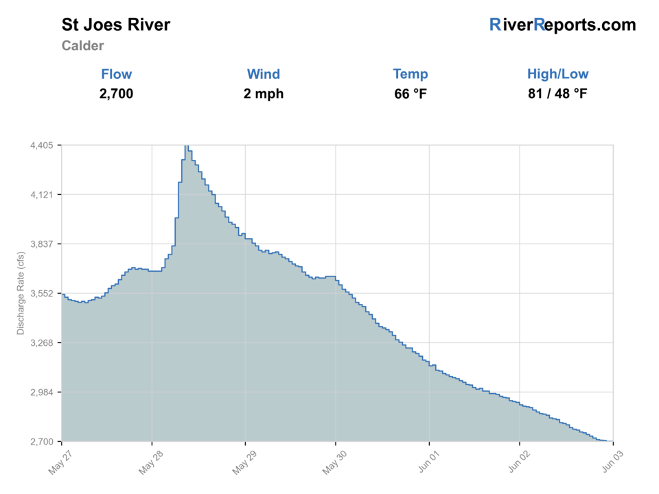
USGS flow
2,700 cfs
Current trend: flow falling, rating likely holding strong unless weather or clarity changes.
More planning details: flies, flow bands, and live source checks
Fish it today
Start here
Start with the Calder and Avery corridor for the most practical read on flows and access, then decide whether the day fits roaded lower water, campground-based fishing, or a more remote upper-river scout.
Best flow clue
Use the RiverReports Calder chart and USGS 12414500 together. Stable or slowly falling post-runoff flows are the best window; high snowmelt, storm color, or warm low water should move the plan to safer edges, a different reach, or another river.
Skip trigger
Skip the trip when cutthroat rules are unclear, when runoff makes wading unsafe, when forest-road or weather conditions make the upper corridor risky, when access signs do not support the bank you planned to fish, or when warm low water would stress trout.
Flow decision bands
Low but fishable
Low clear cutthroat water can fish well with stealth and quick releases when temperatures stay safe.
Best cutthroat window
Stable or slowly falling Calder flow after runoff, clear water, and current IDFG rules make the best dry-fly, dry-dropper, caddis, stonefly, and terrestrial signal.
Pushy or unsafe
Runoff, storm color, or canyon current should stop crossings and keep anglers on safe banks or another river.
Forest-road caution
Road status, fire restrictions, campground rules, private banks, and remote upper-corridor travel can matter as much as the gauge.
USGS flow
2,700 cfs
Current trend: flow falling, rating likely holding strong unless weather or clarity changes.
Live USGS flow
2,700 cfs / falling about 12%
Live NWS forecast
65F / Partly Sunny
Water temperature not verified
Heat guidance uses weather and river type unless an official water-temperature value is available.
No NWS alert flag
No active NWS alert was returned for this forecast point.
Use the Calder RiverReports and USGS gauge for the main condition check.
Check IDFG rules for lower and upper sections, including barbless/no-bait language.
Expect spring runoff and cold water to control early-season safety.
Upper access requires more road, weather, and wildfire awareness.
Editorial review
How this report is maintained
This St. Joe River report is maintained from RiverReports and USGS flow data, Idaho Fish and Game rule information, Forest Service corridor access references, weather checks, and northern Idaho cutthroat planning guidance.
Byline
BlueStreamFly editorial team
Reviewed by
BlueStreamFly source review
Maintained by
Mountain Brook Run LLC
Last material review
2026-05-31
Report confidence
High confidence
90/100
High confidence: RiverReports, USGS 12414500, Idaho Fish and Game St. Joe information, Forest Service access context, and weather data support the page. Confidence is moderated by private-bank gaps, forest-road conditions, fire-season changes, upper-corridor remoteness, and warm low water.
Regulations
Idaho Fish and Game St. Joe River information supports current reach and cutthroat-rule checks.
Access
Forest Service corridor information supports public planning, while private boundaries, road conditions, campground rules, and site-specific signs still need trip confirmation.
Flow and weather
RiverReports, USGS 12414500, and the National Weather Service point are attached to the route.
Fishing usefulness
The page now separates Calder, Avery, lower roaded water, upper remote water, runoff, heat, access, and Coeur d'Alene or Clearwater backups.
Fishability dashboard and source review
2026-05-31 / material content or source review
RiverReports and USGS Calder flow, Idaho Fish and Game St. Joe information, Forest Service Shadowy St. Joe River access context, and the National Weather Service point were checked before updating the current fishability guidance.
2026-05-31
Updated St. Joe River with Calder trend guidance, cutthroat and forest-road access cards, runoff and warm-water cautions, backup cues, stable fishability SEO, and confidence signals.
2026-05-28
Added Calder, Avery, roaded lower-river, and upper Wild and Scenic trip-fit guidance, wade-and-bank framing, cutthroat-rule and runoff skip cues, forest-road access nuance, pressure timing, backup-water suggestions, editorial review signals, and a page-specific report-confidence meter after source checks.
2026-05-24
Initial source-reviewed report published with flows, weather, hatches, flies, tactics, access, regulations, and FAQs.
Angler planning edge
Local details that change the plan
Best for
Anglers planning a northern Idaho cutthroat day with St. Joe reach rules checked first, Dry-fly, dry-dropper, caddis, stonefly, attractor dry, terrestrial, and small streamer windows when flows are clear and safe, Trips where forest-road access, upper-river remoteness, private boundaries, native cutthroat handling, and campground logistics matter, Anglers comparing the St. Joe with the Coeur d'Alene, Clearwater, or Silver Creek for a different Idaho trout plan
Wade or float
Treat the St. Joe as a wade-and-bank planning report first. Some roaded sections allow easy scouting, but the better plan is to pair the Calder gauge with the exact reach, public access, road conditions, and cutthroat rules before committing.
Best flows
Use the RiverReports Calder chart and USGS 12414500 together. Stable or slowly falling post-runoff flows are the best window; high snowmelt, storm color, or warm low water should move the plan to safer edges, a different reach, or another river.
When to skip
Skip the trip when cutthroat rules are unclear, when runoff makes wading unsafe, when forest-road or weather conditions make the upper corridor risky, when access signs do not support the bank you planned to fish, or when warm low water would stress trout.
Local plan
Start with the Calder and Avery corridor for the most practical read on flows and access, then decide whether the day fits roaded lower water, campground-based fishing, or a more remote upper-river scout.
Pressure
The St. Joe has room, but famous cutthroat water and easy road pullouts can concentrate anglers in prime summer windows. Early timing, careful approach, and respectful spacing usually matter more than changing flies often.
Access nuance
Forest Service context supports the public corridor, but private banks, road pullouts, campground rules, fire restrictions, and upper-river travel conditions still need current confirmation.
Backup water
If the St. Joe is high, warm, crowded, or access-limited, compare the Coeur d'Alene River, Clearwater River, or Silver Creek after checking current rules, flows, and travel time.
About the river
Setting, character, and why it fishes the way it does.
The St. Joe River drains forested northern Idaho country and is known for clear water, native cutthroat, and a long scenic corridor.
USFS describes a Wild and Scenic river with road-access recreation in parts and a more primitive upper section.
The lower river, upper no-bait/barbless sections, campgrounds, and remote roads create very different fishing days.
A useful St. Joe plan keeps cutthroat conservation, flow, road access, and seasonal runoff together.
Target species
Westslope cutthroat trout
The main target and the species that drives careful identification and release-focused planning.
Bull trout
Present in the system; handle conservatively and check current IDFG rules.
Mountain whitefish
Common in cold riffles and runs.
Lower-system species
Rainbow, smallmouth, and northern pike are part of broader lower-river context, not the upper cutthroat plan.
Reading the water
Post-runoff stable
Best for attractor dries, caddis, and dry-droppers in riffles and pocket water.
High runoff
Avoid unsafe wading and wait for the Calder gauge to settle.
Low clear summer
Use stealth, smaller dries, and lighter tippet in visible pools.
Warm lower water
Move higher, fish early, and stop if trout recovery is poor.
Best seasons
Late spring
Useful only after runoff begins to settle and roads are manageable.
Summer
Prime dry-fly cutthroat season with caddis, stones, and terrestrials.
Fall
Cooler water, BWOs, and fewer anglers can make strong days.
Winter
Cold, road access, and ice make this a limited plan.
Preferred flow source
St. Joe River at Calder
RiverReports is the preferred chart source when coverage exists. When a matching USGS gauge exists, keep it open as the official backstop for station data and current hydrograph context.
USGS data chart
Official USGS trend
Streamflow over the latest USGS reporting window.
Latest
2,700 cfs
Jun 3, 4 PM UTC
Weather
River weather report
Weather can change wading safety, road access, water temperature, hatches, and the best time of day to fish.
Live forecast loads as you reach this section
This keeps the report fast while still using the official National Weather Service forecast point.
Hatches and flies
Hatch chart and fly picks
Spring
Midges, BWOs, early caddis
BWO emerger, zebra midge, caddis pupa, pheasant tail
Early summer
Caddis, golden stones, PMDs
Elk hair caddis, stimulator, PMD dry, stonefly nymph
Late summer
Hoppers, ants, beetles, caddis
Hopper, ant, beetle, small caddis, perdigon
Fall
BWOs, midges, October caddis
BWO dry, soft hackle, October caddis, zebra midge
Cutthroat dries
Stimulator, elk hair caddis, PMD, BWO, ant, beetle
Use after runoff when cutthroat are rising in broken water.
Dry-droppers
Chubby, hopper, perdigon, pheasant tail, caddis pupa
Use to search riffles, pockets, and banks.
Nymphs
Prince, hare's ear, pheasant tail, stonefly, zebra midge
Use during cold water or before surface feeding starts.
Streamers
Bugger, sculpin, leech
Use in deeper banks or cloudy, higher-water windows.
Tactics
How to fish it
Wait for runoff to drop before planning a dry-fly cutthroat day.
Fish attractor dries through riffles and pocket water in summer.
Move higher when lower water warms.
Check upper-reach barbless/no-bait rules before fishing above the North Fork.
Use road and wildfire conditions as part of the access plan.
Rigging
Rod, leader, and setup notes
A 9-foot 4-weight or 5-weight is ideal for most cutthroat fishing.
Use 4X to 6X depending on clarity and fly size.
Carry a short dry-dropper rig for searching water.
Bring a wading staff for slick cobble and cold spring flows.
Pack layers and a road map for upper-river travel.
Access
Access and planning notes
Calder gauge corridor
Primary runoff checkWade / float / trail
Gauge / roaded wade / bank
When to pick it
Start here when runoff, clarity, and wading safety decide the day.
Caution
A lower-river gauge does not make every upper pullout safe or public.
Avery and roaded St. Joe
Practical public scoutWade / float / trail
Road / campground / wade
When to pick it
Use it when road access and campground-based fishing are central.
Caution
Confirm current road, fire, and campground conditions before driving deep into the corridor.
Upper cutthroat water
Native trout focusWade / float / trail
Remote wade / bank
When to pick it
Pick it when flows are settled, water is cool, and IDFG rules support the target reach.
Caution
Native cutthroat handling and private-boundary awareness should stay conservative.
Rules differ by lower and upper reaches.
Spring runoff can make familiar wades unsafe.
Road closures, wildfire, and remote travel can affect upper access.
Respect campsites, pullouts, and private land.
Regulations
Check before fishing
IDFG lists St. Joe River rules by reach, including cutthroat harvest restrictions and no-bait/barbless language upstream. Check current rules before fishing.
Primary base
St. Maries, Avery, or Coeur d'Alene
Best day style
Roaded river corridor, forest access, upper remote water, campgrounds, and private boundaries
Check first
Calder flow, IDFG cutthroat rules, road conditions, weather, and wildfire/access updates
Safety
Spring runoff, cold water, remote roads, upper-river travel, and rule differences by reach
Gear
Helpful gear for this water
Attractor dries
Caddis, stimulators, ants, beetles, and small mayflies are core summer flies.
Thermometer
Useful for lower-river summer decisions.
Road kit
Upper access can be remote enough to need extra water, layers, and fuel planning.
Wading staff
Helpful during runoff shoulder seasons and slick cobble wades.
Nearby water
Other water to research
Backup logic
High water
Compare the Coeur d'Alene, Clearwater, or a smaller confirmed public reach after checking flows.
Heat
Fish early, keep cutthroat wet, and stop trout pressure when low warm water becomes stressful.
Storms or road issues
Delay remote upper-river travel when storms, fire restrictions, or forest-road conditions are uncertain.
Access issue
Use confirmed Forest Service or IDFG-supported access only; pivot if private banks or road signs do not support the plan.
Coeur d'Alene River
A nearby northern Idaho cutthroat and whitefish option with roaded access.
Clearwater River
Bigger water with steelhead, salmon, and Orofino flow planning.
Silver Creek
A very different Idaho technical spring-creek plan.
FAQ
Fast answers
Is St. Joe River fishable today?
St. Joe River looks very fishable right now. The live score is 96/100, based on current flow, weather, public alerts, and the report's planning context. Recheck the linked gauge and forecast before leaving because conditions can change quickly after rain, heat, access changes, or flow swings.
What flow is best for St. Joe River?
Use the RiverReports Calder chart and USGS 12414500 together. Stable or slowly falling post-runoff flows are the best window; high snowmelt, storm color, or warm low water should move the plan to safer edges, a different reach, or another river.
When should I skip St. Joe River?
Skip the trip when cutthroat rules are unclear, when runoff makes wading unsafe, when forest-road or weather conditions make the upper corridor risky, when access signs do not support the bank you planned to fish, or when warm low water would stress trout.
Is St. Joe River safe to wade right now?
The fishability score is not a wading guarantee. Wade only where your chosen access has safe edges, clear footing, legal entry, and no forced crossings; high, rising, stained, or storm-affected water should be treated conservatively.
What is the best St. Joe River season?
After runoff drops and before lower water warms, summer dry-fly fishing is the classic window.
Which gauge should I use?
Use USGS 12414500 at Calder, shown with RiverReports and official USGS context.
Are the upper rules different?
Yes. IDFG lists different language for upper sections, including no-bait and barbless-hook rules.
Is this mostly a cutthroat river?
For fly anglers, yes. Native cutthroat are the core target and should be handled carefully.
Sources
Source set for this report
Reviewed 2026-05-31