
Colorado / West
South Fork Rio Grande
A practical South Fork Rio Grande page for anglers deciding whether the small valley water near town still has enough cold flow, legal access, and cover for a worthwhile session.
Image: Generated regional planning image for South Fork Rio Grande / BlueStreamFly generated; not exact location / BlueStreamFlyFishability now: South Fork Rio Grande fishability today
GoodData confidence: High74/100
Fishable now because flow has been checked, weather is mild, and no public alert is active.
Flow observed
Not returned
Weather observed
4:00 PM UTC
Score calculated
4:20 PM UTC
Why this rating
Flow
Weather
Public alerts
Next 6-12 hours
Hold
Stable live data supports staying with the plan, but recheck the gauge and forecast before leaving.
USGS flow
Check gauge
Current trend: previous-score comparison will become more useful after repeated live checks.
More planning details: flies, flow bands, and live source checks
Fish it today
Start here
Check the gauge at breakfast, fish one named public access point cleanly, then either move upstream to colder water or switch basins.
Best flow clue
Stable clear flows that still define pockets, grassy seams, and undercut edges without muddy runoff.
Skip trigger
Skip during dirty runoff, hot late-day summer conditions, or when the river looks too thin to keep trout covered.
Flow decision bands
Low but fishable
Low clear South Fork water can fish in riffles, bends, and shaded runs when trout temperatures remain safe.
Best mountain-valley window
Stable or falling South Fork flow with clear water and mild weather gives the best dry-dropper, nymph, and terrestrial signal.
Runoff or storm unsafe
High snowmelt, thunderstorm color, or fast banks should stop crossings and deep wading.
Short-reach access caution
A good graph still needs current forest access, road, and public-bank confirmation.
USGS flow
Check gauge
Current trend: previous-score comparison will become more useful after repeated live checks.
No current flow value
The source loaded, but did not return streamflow or gauge height.
Live NWS forecast
65F / Sunny
Water temperature not verified
Heat guidance uses weather and river type unless an official water-temperature value is available.
No NWS alert flag
No active NWS alert was returned for this forecast point.
RiverReports is the working flow chart, backed by USGS 08219500 at South Fork for official gauge context.
Colorado's current Rio Grande regulations in Rio Grande County keep this reach artificial-fly-and-lure-only, with rainbow trout release requirements and special brown-trout harvest limits on nearby main-stem sections around South Fork.
Rio Grande National Forest lists Highway Springs Campground as direct access to the South Fork of the Rio Grande just west of town.
This is a better morning or shoulder-season river than a late-day midsummer grind.
Editorial review
How this report is maintained
This report uses official regulation, flow, weather, access, and public-land sources first, then adds practical planning guidance for fly anglers.
Byline
BlueStreamFly editorial desk
Reviewed by
BlueStreamFly source review
Maintained by
BlueStreamFly
Last material review
2026-05-31
Report confidence
Good confidence
87/100
Good confidence: RiverReports, USGS 08219500 flow, Rio Grande National Forest access sources, Colorado regulation sources, cutthroat context, and weather data support the page. Confidence is moderated by short reach scope, forest-road conditions, runoff swings, warm low-water afternoons, and public-bank specifics.
Regulations
Colorado regulation sources support the legal-check path before choosing South Fork water.
Access
Rio Grande National Forest Highway Springs and South Fork Region sources support public access planning, with exact site status and banks still needing current confirmation.
Flow and weather
RiverReports, USGS 08219500, and the National Weather Service point are attached to the route.
Fishing usefulness
The page now separates South Fork gauge checks, forest access, campground planning, runoff, heat, storms, and Rio Grande-area backup choices.
Fishability dashboard and source review
2026-05-31 / material content or source review
RiverReports South Fork Rio Grande chart, USGS 08219500 flow data, Rio Grande National Forest Highway Springs and South Fork Region access sources, Colorado regulation sources, Rio Grande cutthroat context, and the National Weather Service point were checked before updating the current fishability guidance.
2026-05-31
Updated South Fork Rio Grande with USGS trend guidance, Highway Springs and South Fork access cards, runoff and warm-water cautions, backup cues, stable fishability SEO, and confidence signals.
2026-05-29
Added a page-specific report-confidence meter for South Fork Rio Grande flow, Rio Grande National Forest access, Colorado rule checks, weather, and short-session mountain-valley planning.
2026-05-26
Published a new South Fork Rio Grande report with gauge context, access anchors, regulation guardrails, and short-session planning guidance.
Angler planning edge
Local details that change the plan
Best for
Short mountain-valley sessions, Morning dry-dropper fishing, South Fork basecamp backups
Wade or float
Wade only. This is a compact river plan built around short entries and careful bank coverage.
Best flows
Stable clear flows that still define pockets, grassy seams, and undercut edges without muddy runoff.
When to skip
Skip during dirty runoff, hot late-day summer conditions, or when the river looks too thin to keep trout covered.
Local plan
Check the gauge at breakfast, fish one named public access point cleanly, then either move upstream to colder water or switch basins.
Pressure
Pressure gathers close to town and named access. The better play is often fishing the first good hour well, not chasing mileage.
Access nuance
The main challenge is not finding water but finding durable public entry without assuming every roadside opening is fair game.
Backup water
Shift to the main-stem Rio Grande or another higher, colder tributary if the South Fork loses temperature or clarity.
About the river
Setting, character, and why it fishes the way it does.
The South Fork Rio Grande rises high in the San Juan Mountains and drops into the valley around the town of South Fork, where public-forest edges and roadside access make it one of the quicker trout options in the upper Rio Grande basin.
Its appeal is convenience and mountain setting, but the river fishes best when you stay honest about size, temperature, and flow. This is not a place to force long hours once the water flattens out.
Think of it as a reach where flow shape and cold mornings matter more than checking off miles.
Target species
Brown trout
A realistic primary target where depth, wood, and undercut banks hold fish through stable flows.
Rainbow trout
Present in the drainage, with current Colorado rules requiring release on nearby special-regulation main-stem sections.
Rio Grande cutthroat trout
Important basin-native context in upper tributary conservation waters, even when the town reach is more mixed-fishery than pure native-trout water.
Brook trout
More likely in colder upper tributaries and pocket-water side plans.
Reading the water
Stable moderate flow
Best for dry-dropper rigs, pocket-water nymphing, and fishing the shade line along wood or grass.
Low clear summer flow
Fish early, keep drifts short, and favor the coldest looking current under cover.
High or stained runoff
Usually not worth forcing because the river is small enough to lose clarity fast.
Hot bright afternoon
A sign to stop or move to colder headwater water instead of stretching the day.
Best seasons
Late spring
Useful once runoff drops enough to show seams, pockets, and bank definition again.
Early summer
Usually the best balance of flow, temperature, and fishable current around town.
Mid summer
Still possible at first light, but the responsible window can get short.
Early fall
A strong reset when nights cool and the river gets easier to read.
Preferred flow source
South Fork Rio Grande at South Fork
RiverReports is the preferred chart source when coverage exists. When a matching USGS gauge exists, keep it open as the official backstop for station data and current hydrograph context.
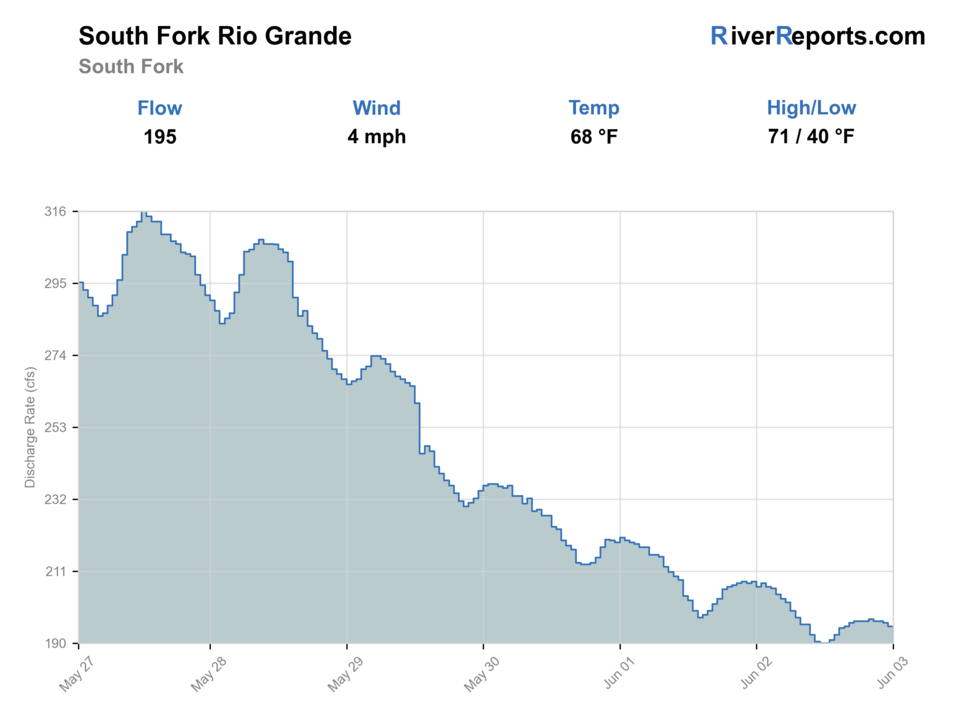
USGS data chart
Official USGS trend
Streamflow over the latest USGS reporting window.
Weather
River weather report
Weather can change wading safety, road access, water temperature, hatches, and the best time of day to fish.
Live forecast loads as you reach this section
This keeps the report fast while still using the official National Weather Service forecast point.
Hatches and flies
Hatch chart and fly picks
Spring
Midges, BWOs, and small stones
Zebra midge, RS2, small stonefly nymph
Early summer
Caddis, PMDs, yellow sallies
Elk hair caddis, PMD emerger, yellow stimulator
Summer
Caddis and terrestrials
Foam ant, beetle, hopper, caddis pupa
Fall
BWOs and midges
Parachute BWO, soft hackle, zebra midge
Dry-dropper
Stimulator, caddis dry, hopper, tungsten perdigon
The river has enough push to keep fish in pocket water and along grassy banks.
Short nymph rig
Pheasant tail, hare's ear, zebra midge, stonefly nymph
Cool mornings or deeper runs demand more depth without long drifts.
Low-water dries
Parachute Adams, ant, beetle, caddis emerger
The river is clear and trout are sliding into softer slicks near cover.
Tactics
How to fish it
Check the South Fork gauge before you leave town and fish only the pieces that still look like cold trout water.
Make short accurate casts to undercuts, pocket heads, and seams beside wood rather than trying to fish every visible run.
If afternoon sun or muddy runoff removes the river's shape, move to another basin option instead of forcing it.
Treat each campground or pull-off stop as a compact session with a clear exit point.
Rigging
Rod, leader, and setup notes
A 3- to 5-weight floating-line setup covers nearly every South Fork Rio Grande day.
Carry 4X through 6X tippet because the river swings between fast little pockets and clear low-water edges.
One short dry-dropper setup and one compact nymph leader are enough for most windows.
A thermometer matters because this river can look fishable after the cold-water window is already narrowing.
Access
Access and planning notes
Highway Springs Campground
Forest access anchorWade / float / trail
USFS / campground / wade
When to pick it
Start here when campground status, flow, and weather support a short public-water plan.
Caution
Campground access is seasonal and does not solve every nearby bank.
South Fork Region access context
Trip base and public-land checkWade / float / trail
USFS / road / wade scout
When to pick it
Use it when deciding whether town-based or forest-based water fits the day.
Caution
Road, wildfire, and posted-site conditions need current checks.
South Fork gauge area
Flow and heat decisionWade / float / trail
Gauge / bank scout
When to pick it
Pick it before deciding whether low or high water supports trout fishing.
Caution
Gauge conditions still need on-site clarity and temperature checks.
Public access is real, but it is not continuous meadow access. Use named public sites and durable entries first.
Do not assume every roadside opening is a good or legal fishing stop.
The best plan is usually one or two short sessions with a larger backup river ready.
Regulations
Check before fishing
Use the current Colorado Parks and Wildlife fishing brochure before fishing. The South Fork and nearby Rio Grande sections around South Fork carry artificial-fly-and-lure-only rules, rainbow release requirements, and section-specific brown-trout limits that need to be checked for the exact water you are standing on.
Primary base
South Fork
Best day style
Short walk-wade sessions from Highway 160 pull-offs, campground access, and public-forest edges
Check first
RiverReports trend, USGS 08219500, current Colorado fishing rules, and morning weather
Safety
Runoff color, warm afternoons, slick grassy banks, roadside traffic, and fast pocket water
Gear
Helpful gear for this water
3- to 5-weight rod
Enough rod for dries, droppers, and compact nymph rigs.
Thermometer
Important for deciding when the small valley river has already gone too warm.
Wading boots with good edging
Useful on grassy banks, loose cobble, and short steep entries.
Light rain layer
Mountain weather and runoff color can change quickly.
Nearby water
Other water to research
Backup logic
High water
Compare the main Rio Grande, Rio de Los Pinos, or higher tributary water after checking access.
Heat
Fish early, move higher, or stop trout pressure in thin warm water.
Storms or road issues
Delay when lightning, mud, wildfire notices, or forest-road issues affect the corridor.
Access issue
Use Forest Service-listed access only; pivot to another signed Rio Grande-area option if banks are unclear.
Rio Grande
The broader valley-river backup when you want more water and a more durable plan.
Conejos River
A southern Colorado alternative with more classic freestone mileage.
Big Meadows area tributaries
Higher, colder backup options when the town reach gets warm or flat.
FAQ
Fast answers
Is South Fork Rio Grande fishable today?
South Fork Rio Grande looks fishable right now. The live score is 74/100, based on current flow, weather, public alerts, and the report's planning context. Recheck the linked gauge and forecast before leaving because conditions can change quickly after rain, heat, access changes, or flow swings.
What flow is best for South Fork Rio Grande?
Stable clear flows that still define pockets, grassy seams, and undercut edges without muddy runoff.
When should I skip South Fork Rio Grande?
Skip during dirty runoff, hot late-day summer conditions, or when the river looks too thin to keep trout covered.
Is South Fork Rio Grande safe to wade right now?
The fishability score is not a wading guarantee. Wade only where your chosen access has safe edges, clear footing, legal entry, and no forced crossings; high, rising, stained, or storm-affected water should be treated conservatively.
What should I check first on the South Fork Rio Grande?
Start with RiverReports and USGS 08219500 at South Fork, then confirm the exact Colorado regulation section that matches the water you plan to fish.
Is this a full-day river?
Usually it is better as a short cold-water session, especially in midsummer when the best window is early.
Where is the cleanest public starting point?
Highway Springs Campground is the clearest named public access west of town, with other stops depending on safe parking and durable entry.
Sources
Source set for this report
Reviewed 2026-05-31