
Colorado / West
Lake Fork of the Gunnison
A practical Lake Fork report for Gunnison-country access, BLM bank fishing, flows, hatches, and high-elevation trip timing.
Image: Generated regional planning image for Lake Fork of the Gunnison / BlueStreamFly generated; not exact location / BlueStreamFlyFishability now: Lake Fork of the Gunnison fishability today
GreatData confidence: High96/100
Fishable now because the live gauge is stable, weather is mild, and no public alert is active.
Flow observed
3:15 PM UTC
Weather observed
4:00 PM UTC
Score calculated
4:20 PM UTC
Why this rating
Flow
Water temperature
Public alerts
Next 6-12 hours
Hold
Stable live data supports staying with the plan, but recheck the gauge and forecast before leaving.
USGS flow
273 cfs
Current trend: flow stable, so weather, temperature, and access checks drive the next change.
More planning details: flies, flow bands, and live source checks
Fish it today
Start here
Base near Lake City or Gunnison, check the gauge, choose one public access segment, and keep Blue Mesa or lower Gunnison options ready.
Best flow clue
Stable post-runoff flows with safe edges, defined riffles, and enough clarity to read banks and pool heads.
Skip trigger
Skip during heavy runoff, cold storm days, or when access roads and water depth create more risk than fishing value.
Flow decision bands
Low but fishable
Low clear Lake Fork water can fish in riffles, pool heads, and banks when temperatures and access are safe.
Best post-runoff window
Stable or falling Gateview flow with clear water and mild weather is the strongest dry-dropper, nymph, and streamer signal.
Runoff or cold storm unsafe
Heavy runoff, cold storm spikes, or difficult roads should move the plan to easier water.
Campground and road caution
Public access is good, but site status, road condition, and obvious pullout pressure still affect the day.
USGS flow
273 cfs
Current trend: flow stable, so weather, temperature, and access checks drive the next change.
Live USGS flow
273 cfs / stable
Live NWS forecast
72F / Mostly Sunny
Live water temperature
50F from USGS
No NWS alert flag
No active NWS alert was returned for this forecast point.
RiverReports provides the quick chart, with USGS 09124500 as the official flow backing for this report.
BLM describes about 14 miles of public fishing access, making this one of the stronger public-access pages in the batch.
Most anglers should think bank and wade fishing first, not boating from small campground access.
High-country weather, cold water, and seasonal roads should shape the day as much as hatch timing.
Editorial review
How this report is maintained
This report uses official regulation, flow, weather, access, and public-land sources first, then adds practical planning guidance for fly anglers.
Byline
BlueStreamFly editorial desk
Reviewed by
BlueStreamFly source review
Maintained by
BlueStreamFly
Last material review
2026-05-31
Report confidence
Good confidence
88/100
Good confidence: RiverReports Lake Fork chart, USGS 09124500 flow, BLM river and campground access, Colorado regulation sources, and weather data support the page. Confidence is moderated by road status, campground pressure, storm timing, and reach-specific access.
Regulations
Colorado regulation sources support the legal-check path before choosing Lake Fork water.
Access
BLM Lake Fork and Mill Creek sources support public access planning, with site status and exact banks still needing current confirmation.
Flow and weather
RiverReports, USGS 09124500, and the National Weather Service point are attached to the route.
Fishing usefulness
The page now separates Gateview flow, BLM access, campground pressure, post-runoff timing, cold storms, roads, and backup choices.
Fishability dashboard and source review
2026-05-31 / material content or source review
RiverReports Lake Fork of the Gunnison chart, USGS 09124500 Gateview flow data, BLM Lake Fork of the Gunnison and Mill Creek access sources, Colorado regulation sources, and the National Weather Service point were checked before updating the current fishability guidance.
2026-05-31
Updated Lake Fork of the Gunnison with Gateview trend guidance, BLM access cards, post-runoff, road, and cold-storm cautions, backup cues, stable fishability SEO, and confidence signals.
2026-05-29
Added a page-specific report-confidence meter for Lake Fork of the Gunnison flow, BLM access anchors, Colorado rule checks, weather, and high-country trip planning.
2026-05-25
Published a new Lake Fork of the Gunnison report with public-access guidance, flow context, hatch planning, and high-country safety notes.
Angler planning edge
Local details that change the plan
Best for
Public wade access, High-country trout trips, Summer and early fall dry-dropper fishing
Wade or float
Wade and bank fish first. This report does not treat campground river access as a recommended boating launch.
Best flows
Stable post-runoff flows with safe edges, defined riffles, and enough clarity to read banks and pool heads.
When to skip
Skip during heavy runoff, cold storm days, or when access roads and water depth create more risk than fishing value.
Local plan
Base near Lake City or Gunnison, check the gauge, choose one public access segment, and keep Blue Mesa or lower Gunnison options ready.
Pressure
Public access spreads anglers out better than many mountain streams, but obvious pullouts still collect pressure.
Access nuance
The BLM access framework is strong, but site status and posted boundaries still decide the exact plan.
Backup water
Lower Gunnison River is the cleanest backup when the Lake Fork is high, windy, or too cold.
About the river
Setting, character, and why it fishes the way it does.
The Lake Fork of the Gunnison drains high country near Lake City before entering Blue Mesa Reservoir. That setting gives anglers cold water, mountain weather, and a mix of public bank access and campground-based planning.
BLM-managed access is the practical anchor for this page. It gives anglers a public framework, but individual pullouts and banks still need daily judgment.
The river rewards anglers who read depth changes, banks, and soft seams carefully instead of trying to cover every mile.
Target species
Brown trout
A common target in riffles, undercuts, and pool edges.
Rainbow trout
Present in public access reaches and stocked or managed sections.
Kokanee salmon
A seasonal fall context near the reservoir system; check current rules before targeting or retaining fish.
Reading the water
Low clear water
Use smaller dries, light nymphs, and careful bankside approaches.
Moderate stable flow
Best all-around wade condition for dry-dropper, nymph, and streamer coverage.
High runoff
Fish protected edges only if safe, or delay until the river drops.
Cold high-country weather
Start later, slow the presentation, and plan for fast weather changes.
Best seasons
Late spring
Runoff controls the day; use only safe edges when the river is still high.
Summer
Prime access and hatch season once flows settle.
Early fall
Often the best mix of clear water, cool nights, and quieter pressure.
Late fall
Weather and road comfort become the limiting factors.
Preferred flow source
Lake Fork of the Gunnison
RiverReports is the preferred chart source when coverage exists. When a matching USGS gauge exists, keep it open as the official backstop for station data and current hydrograph context.
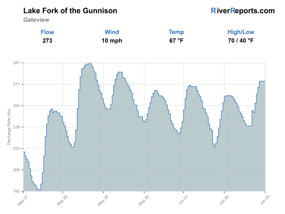
USGS data chart
Official USGS trend
Streamflow over the latest USGS reporting window.
Latest
273 cfs
Jun 3, 3 PM UTC
Weather
River weather report
Weather can change wading safety, road access, water temperature, hatches, and the best time of day to fish.
Live forecast loads as you reach this section
This keeps the report fast while still using the official National Weather Service forecast point.
Hatches and flies
Hatch chart and fly picks
Spring
Midges, BWOs, caddis, and stoneflies
Zebra midge, BWO emerger, prince nymph, pats rubber legs
Summer
Caddis, PMDs, yellow sallies, ants, and beetles
Elk hair caddis, PMD, yellow sally, ant
Late summer
Terrestrials and evening caddis
Hopper, beetle, caddis pupa, soft hackle
Fall
BWOs, midges, and streamer windows
RS2, midge larva, olive bugger, small streamer
Public-access searching
Chubby, elk hair caddis, perdigon, pheasant tail
Use while covering banks and riffles.
Deeper runs
Pats rubber legs, prince nymph, hare's ear, jigged pheasant tail
Use when water is cold or fish hold deeper.
Clear-water dries
PMD, BWO, ant, beetle, parachute Adams
Best in slower edges and lower flows.
Tactics
How to fish it
Start with the public-access framework, then choose a short reach with clean entry and exit points.
Fish banks, pool heads, and riffle seams before stepping into the best water.
Use dry-dropper rigs when fish are looking up, and switch to a compact nymph rig in colder or deeper water.
Keep a reservoir or lower Gunnison backup if runoff or wind makes the Lake Fork uncomfortable.
Rigging
Rod, leader, and setup notes
A 4- or 5-weight floating line setup covers the core trout fishing.
Carry 3X to 6X tippet for everything from streamers and stoneflies to small dries.
Use a small indicator or euro-style rig only where depth justifies it.
Bring layers, sun protection, and a wading staff for long high-country days.
Access
Access and planning notes
BLM Lake Fork of the Gunnison
Primary public river planWade / float / trail
BLM / wade / bank
When to pick it
Start here when flow and weather support a focused public reach.
Caution
Confirm site status and posted boundaries before fishing.
Mill Creek Campground area
Access and pressure checkWade / float / trail
BLM campground / bank / wade
When to pick it
Use it when camping or obvious public entry is part of the plan.
Caution
Campground pressure and road condition can limit practical water.
Lake City / Gateview context
Flow and reach selectionWade / float / trail
Gauge / road / wade
When to pick it
Pick it when deciding whether the reach is safe and clear enough.
Caution
The gauge does not remove the need for on-site clarity and bank checks.
BLM access is the main reason this page is useful, but still check site status, road conditions, and posted boundaries.
Do not assume campground access means safe boating access; BLM notes river access but says boating is not recommended from Mill Creek Campground.
High-elevation weather can make even simple wading plans feel exposed.
Regulations
Check before fishing
Check current Colorado fishing regulations before fishing, especially around trout limits, kokanee timing, and any site-specific rules near Blue Mesa or public access areas.
Primary base
Lake City or Gunnison
Best day style
BLM public fishing access, road pullouts, campgrounds, and wade fishing
Check first
RiverReports, USGS 09124500, BLM access, Colorado rules, and weather
Safety
Runoff, cold water, high-elevation storms, road conditions, and wading depth
Gear
Helpful gear for this water
4- or 5-weight rod
Flexible for dries, nymphs, and small streamers.
Wading staff
Helpful around uneven banks and higher flows.
Layer system
High-country weather changes quickly.
Streamer box
Useful in deeper runs and fall windows.
Nearby water
Other water to research
Backup logic
High water
Compare Lower Gunnison or wait for the Gateview trend to fall.
Heat
Fish early or move to colder higher water when trout handling becomes questionable.
Storms or road issues
Delay when cold storms, mud, or road access make the plan reactive.
Access issue
Use BLM-listed access only; pivot to Lower Gunnison or another signed public reach if boundaries are unclear.
Lower Gunnison River
A larger backup when you want more water and broader access planning.
Arkansas River
A bigger freestone alternative if Gunnison-country weather turns.
Blue River
A technical mountain-water contrast for another trip.
FAQ
Fast answers
Is Lake Fork of the Gunnison fishable today?
Lake Fork of the Gunnison looks very fishable right now. The live score is 96/100, based on current flow, weather, public alerts, and the report's planning context. Recheck the linked gauge and forecast before leaving because conditions can change quickly after rain, heat, access changes, or flow swings.
What flow is best for Lake Fork of the Gunnison?
Stable post-runoff flows with safe edges, defined riffles, and enough clarity to read banks and pool heads.
When should I skip Lake Fork of the Gunnison?
Skip during heavy runoff, cold storm days, or when access roads and water depth create more risk than fishing value.
Is Lake Fork of the Gunnison safe to wade right now?
The fishability score is not a wading guarantee. Wade only where your chosen access has safe edges, clear footing, legal entry, and no forced crossings; high, rising, stained, or storm-affected water should be treated conservatively.
Is the Lake Fork of the Gunnison good for public wading?
Yes, this page is built around BLM public access and bank or wade fishing, but every day still needs flow and site checks.
What flow source should I use?
Use RiverReports for the quick chart and USGS 09124500 for official backing.
Is this a boat plan?
Not for most users of this page. Treat it as a bank and wade plan unless you have current local boating knowledge and legal access.
Sources
Source set for this report
Reviewed 2026-05-31