
Colorado / West
Lake Creek
A high-elevation Lake Creek report for the Twin Lakes corridor, with flow checks, short-session tactics, access filters, and weather-aware planning.
Image: Generated regional planning image for Lake Creek / BlueStreamFly generated; not exact location / BlueStreamFlyFishability now: Lake Creek fishability today
GoodData confidence: High74/100
Fishable now because flow has been checked, weather is mild, and no public alert is active.
Flow observed
Not returned
Weather observed
5:00 PM UTC
Score calculated
5:25 PM UTC
Why this rating
Flow
Weather
Public alerts
Next 6-12 hours
Hold
Stable live data supports staying with the plan, but recheck the gauge and forecast before leaving.
USGS flow
Check gauge
Current trend: previous-score comparison will become more useful after repeated live checks.
More planning details: flies, flow bands, and live source checks
Fish it today
Start here
Check the chart in Leadville, scout from official Twin Lakes recreation nodes, then fish one or two clean pocket sequences.
Best flow clue
Clear, stable flows with enough soft edge water to fish without forcing fast current.
Skip trigger
Skip during runoff spikes, storm color, heavy wind, or when access is crowded and unclear.
Flow decision bands
Low but fishable
Low clear Lake Creek water can fish in pockets and soft banks when trout temperatures, public access, and cover line up.
Best high-country pocket window
Stable or falling below-reservoir flow with clear water and mild weather is the best dry-dropper and light-nymph signal.
Runoff or storm unsafe
Runoff spikes, dirty storm color, or fast narrow-channel water should stop crossings and mid-channel wading.
Wind and crowd caution
Twin Lakes wind, recreation traffic, and unclear banks can make a fishable graph less useful.
USGS flow
Check gauge
Current trend: previous-score comparison will become more useful after repeated live checks.
No current flow value
The source loaded, but did not return streamflow or gauge height.
Live NWS forecast
62F / Mostly Sunny
Water temperature not verified
Heat guidance uses weather and river type unless an official water-temperature value is available.
No NWS alert flag
No active NWS alert was returned for this forecast point.
Use RiverReports first because the public chart tracks the Lake Creek below Twin Lakes Reservoir site.
Treat the Leadville Ranger District and Twin Peaks Campground pages as access anchors, then check posted boundaries on the ground.
Dry-dropper rigs and short nymph rigs are more practical than long heavy indicator setups on most fishable pieces.
Skip the creek during hard runoff, storm color, or when high-country weather makes the Twin Lakes corridor unsafe.
Editorial review
How this report is maintained
This report uses official regulation, flow, weather, access, and public-land sources first, then adds practical planning guidance for fly anglers.
Byline
BlueStreamFly editorial desk
Reviewed by
BlueStreamFly source review
Maintained by
BlueStreamFly
Last material review
2026-05-31
Report confidence
Good confidence
88/100
Good confidence: RiverReports Twin Lakes chart, USGS 07085500 flow, Pike-San Isabel access sources, Colorado regulation sources, and weather data support the page. Confidence is moderated by recreation pressure, tight creek scope, wind, release changes, and posted access.
Regulations
Colorado regulation sources support the legal-check path before fishing Lake Creek.
Access
Pike-San Isabel Twin Peaks and Leadville Ranger District sources support public access planning, with exact banks and recreation status still needing current confirmation.
Flow and weather
RiverReports, USGS 07085500, and the National Weather Service point are attached to the route.
Fishing usefulness
The page now separates Twin Lakes access, below-reservoir flow, wind, runoff, storm color, tight-water safety, and backup choices.
Fishability dashboard and source review
2026-05-31 / material content or source review
RiverReports Lake Creek below Twin Lakes Reservoir chart, USGS 07085500 flow data, Pike-San Isabel National Forest Twin Peaks and Leadville Ranger District access sources, Colorado regulation sources, and the National Weather Service point were checked before updating the current fishability guidance.
2026-05-31
Updated Lake Creek with below-Twin-Lakes trend guidance, recreation-node access cards, high-country wind, runoff, and storm cautions, backup cues, stable fishability SEO, and confidence signals.
2026-05-29
Added a page-specific report-confidence meter and added USGS Lake Creek below Twin Lakes Reservoir as the official flow fallback for the Lake Creek report.
2026-05-25
Published a new Lake Creek report with Twin Lakes access planning, flow context, hatch guidance, and high-country safety notes.
Angler planning edge
Local details that change the plan
Best for
Short high-country sessions, Dry-dropper pocket water, Twin Lakes scouting days
Wade or float
Wade only. Fish from the bank first and avoid aggressive mid-channel moves.
Best flows
Clear, stable flows with enough soft edge water to fish without forcing fast current.
When to skip
Skip during runoff spikes, storm color, heavy wind, or when access is crowded and unclear.
Local plan
Check the chart in Leadville, scout from official Twin Lakes recreation nodes, then fish one or two clean pocket sequences.
Pressure
Pressure is usually access-point based; moving quietly beats standing on obvious roadside water.
Access nuance
The Twin Lakes corridor mixes recreation infrastructure, public land, and private boundaries. Start from official sites.
Backup water
Arkansas River is the most useful nearby backup when Lake Creek is high, windy, or too tight.
About the river
Setting, character, and why it fishes the way it does.
Lake Creek drains the Twin Lakes side of the Sawatch Range and gives anglers a high-elevation creek option near Leadville.
The water is smaller and faster than many visitors expect. A good session is built around a few clean pockets, protected edges, and careful footwork.
Because the creek sits near popular Twin Lakes recreation, the best plan is simple: check flow, confirm public access, fish quietly, and keep a backup ready.
Target species
Brown trout
Likely in lower-gradient pockets and deeper edge water where cover is present.
Rainbow trout
Common in stocked and connected Twin Lakes-area trout water.
Cutthroat trout
Possible in colder high-country connected habitat; handle native trout quickly and carefully.
Reading the water
Low and clear
Lengthen leaders, stay low, and fish small dries or light droppers through soft pockets.
Moderate stable flow
Best condition for attractor dries, caddis, and compact dry-dropper rigs.
Runoff or release spike
Move to a safer backup instead of forcing fast whitewater-style edges.
Afternoon wind
Fish early or use slightly heavier dries and short casts to keep control.
Best seasons
Late spring
Watch runoff closely; clear edges can fish, but safety changes fast.
Summer
Prime high-country window for caddis, PMDs, small stones, and terrestrials.
Early fall
Often the cleanest blend of lower water, cool nights, and less recreation traffic.
Winter
Mostly limited by ice, snow, wind, and high-elevation access.
Preferred flow source
Lake Creek below Twin Lakes Reservoir
RiverReports is the preferred chart source when coverage exists. When a matching USGS gauge exists, keep it open as the official backstop for station data and current hydrograph context.
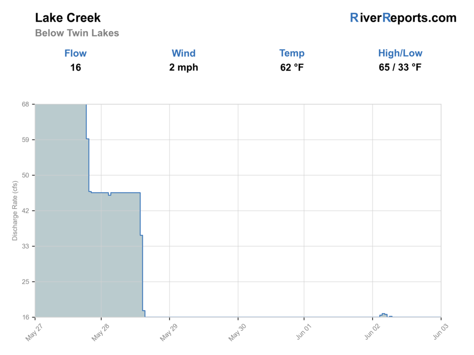
USGS data chart
Official USGS trend
Streamflow over the latest USGS reporting window.
Weather
River weather report
Weather can change wading safety, road access, water temperature, hatches, and the best time of day to fish.
Live forecast loads as you reach this section
This keeps the report fast while still using the official National Weather Service forecast point.
Hatches and flies
Hatch chart and fly picks
Spring
Midges, BWOs, small stones
Zebra midge, RS2, pheasant tail, black stonefly nymph
Summer
Caddis, PMDs, yellow sallies, ants
Elk hair caddis, parachute PMD, yellow stimulator, foam ant
Late summer
Terrestrials and evening caddis
Hopper-dropper, beetle, caddis pupa, soft hackle
Fall
BWOs and midges
Parachute BWO, RS2, zebra midge
High-country dries
Parachute Adams, elk hair caddis, yellow stimulator, foam ant
Use through clear pocket water and small seams.
Droppers
Pheasant tail, perdigon, zebra midge, RS2
Best below a small dry when trout hold just under the surface.
Color or depth
Mini bugger, rubber-leg stone, hares ear
Use only when visibility and wading safety still make sense.
Tactics
How to fish it
Start with the safest public entry, then fish the best nearby water before moving.
Approach from downstream and fish the soft edge before stepping into the creek.
Use short, accurate casts; high-country wind and narrow banks punish long false casts.
Keep Twin Lakes or the Arkansas River as backups if the creek is too high, crowded, or off-color.
Rigging
Rod, leader, and setup notes
A 3- or 4-weight floating-line setup fits most fishable creek water.
Carry 5X and 6X tippet for clear water and small dry-dropper rigs.
Use a compact dry-dropper before adding weight; heavy rigs hang up quickly in pocket water.
Bring a rain shell and warm layer because weather changes fast near Twin Lakes.
Access
Access and planning notes
Twin Lakes recreation nodes
Official access startWade / float / trail
Forest recreation / bank / wade
When to pick it
Start here when flow is stable and official access fits a short session.
Caution
Recreation pressure and posted boundaries still need current checks.
Below Twin Lakes Reservoir
Gauge-area creek planWade / float / trail
Gauge / wade / pocket water
When to pick it
Use it when you want the clearest flow and clarity read.
Caution
Narrow current can get pushy quickly during release or runoff changes.
Leadville Ranger District context
Access and road checkWade / float / trail
Forest office / road / map
When to pick it
Pick it before driving if weather, road, or recreation status may decide the day.
Caution
District context does not replace exact streambank permission.
Do not assume every visible bank is public. Start from official recreation sites and respect posted boundaries.
High altitude, wind, and cold water are part of the plan even on sunny days.
If access feels crowded or unsafe, use the Arkansas River or reservoir shore instead of pressing the creek.
Regulations
Check before fishing
Check the current Colorado fishing brochure and posted site rules before fishing. Lake Creek sits near several public and private use zones, so confirm the exact water you plan to fish.
Primary base
Leadville or Twin Lakes
Best day style
High-country pullouts, campground-area scouting, and short wade sessions
Check first
RiverReports, Colorado regulations, Forest Service site status, and high-country weather
Safety
Runoff, cold water, sudden storms, wind, narrow banks, and high elevation
Gear
Helpful gear for this water
3- or 4-weight rod
Good fit for short drifts and small dry flies.
Warm layer
Twin Lakes weather can turn cold quickly.
Traction
Helpful on slick pocket-water stones and steep banks.
Backup fly box
Carry caddis, PMDs, small stones, and terrestrials.
Nearby water
Other water to research
Backup logic
High water
Compare the Arkansas River instead of forcing fast Lake Creek pocket water.
Heat
Fish early or move higher; stop trout pressure if the creek warms in low water.
Storms or wind
Wait for thunderstorm color and high-country wind to settle before fishing tight banks.
Access issue
Use official Forest Service recreation access only; pivot to the Arkansas if banks or parking are unclear.
Arkansas River
A larger nearby freestone option when Lake Creek is too small or high.
Lake Fork of the Gunnison
Another high-country plan when you are comparing western-slope options.
Clear Creek
A Front Range-style creek backup with easier corridor scouting.
FAQ
Fast answers
Is Lake Creek fishable today?
Lake Creek looks fishable right now. The live score is 74/100, based on current flow, weather, public alerts, and the report's planning context. Recheck the linked gauge and forecast before leaving because conditions can change quickly after rain, heat, access changes, or flow swings.
What flow is best for Lake Creek?
Clear, stable flows with enough soft edge water to fish without forcing fast current.
When should I skip Lake Creek?
Skip during runoff spikes, storm color, heavy wind, or when access is crowded and unclear.
Is Lake Creek safe to wade right now?
The fishability score is not a wading guarantee. Wade only where your chosen access has safe edges, clear footing, legal entry, and no forced crossings; high, rising, stained, or storm-affected water should be treated conservatively.
Is Lake Creek a full-day destination?
Usually it is better as a focused high-country session with a backup ready.
What should I fish first?
Start with a small caddis or attractor dry and a light beadhead dropper.
Does Lake Creek have a USGS gauge?
This page uses the RiverReports Lake Creek chart because a direct USGS station number was not verified for this reach.
Sources
Source set for this report
Reviewed 2026-05-31