
Colorado / West
Homestead Creek
A Homestake Valley planning page built around Gold Park access, public-land constraints, flow checks, and high-country trout timing.
Image: Generated regional planning image for Homestead Creek / BlueStreamFly generated; not exact location / BlueStreamFlyFishability now: Homestead Creek fishability today
GoodData confidence: High78/100
Fishable now because Gold Park gauge is rising, weather is mild, and no public alert is active.
Flow observed
4:45 PM UTC
Weather observed
5:00 PM UTC
Score calculated
5:26 PM UTC
Why this rating
Flow
Weather
Public alerts
Next 6-12 hours
Watch
Recheck within the next few hours; rising water or active weather can change clarity and wading quickly.
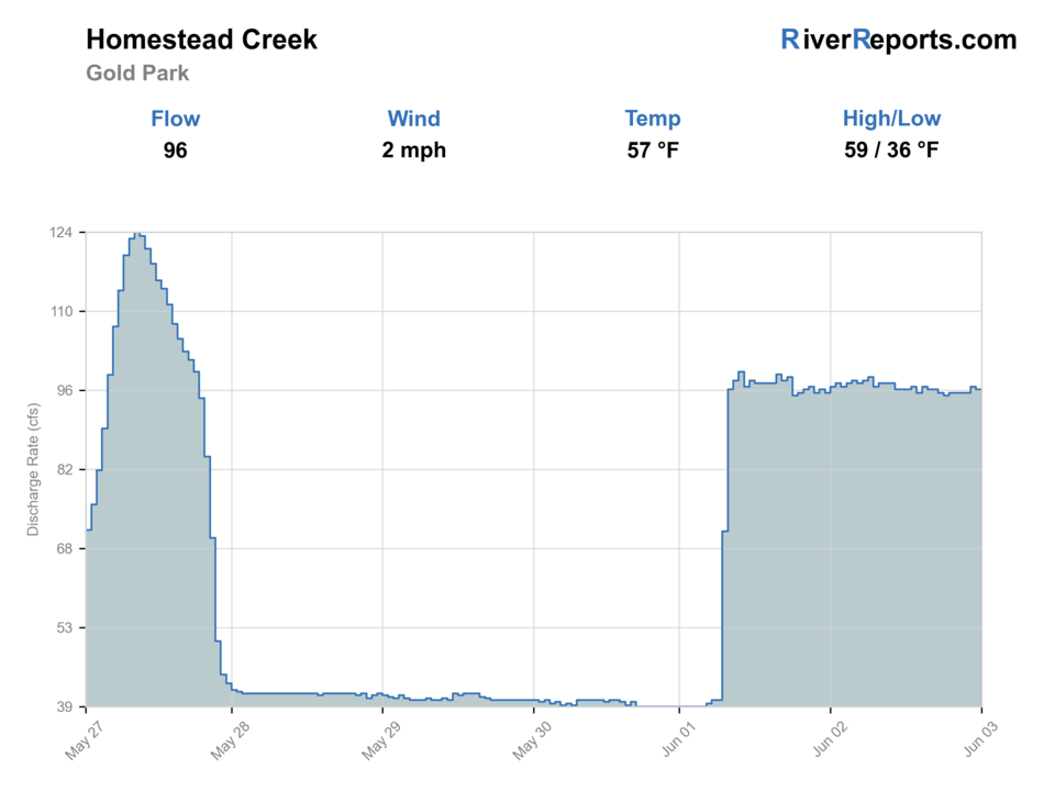
USGS flow
97 cfs
Current trend: flow rising, rating can drop quickly if clarity or wading safety deteriorates.
More planning details: flies, flow bands, and live source checks
Fish it today
Start here
Check the Gold Park chart, pick one public access node, fish the best bends and riffles carefully, then shift valleys if the creek feels too small or busy.
Best flow clue
Stable, clear flows that leave meadow bends and riffle heads fishable without forcing aggressive crossings.
Skip trigger
Skip during runoff, storm-color spikes, or when road and camping pressure make access more complicated than the fishing is worth.
Flow decision bands
Low but fishable
Low clear creek water can fish in meadow bends, riffle heads, and shaded banks when temperatures and public access are safe.
Best meadow-creek window
Stable or falling Gold Park flow with mild weather is the best signal for attractor dries, dry-droppers, and careful short drifts.
Runoff or storm unsafe
Runoff, muddy storm spikes, or fast narrow-channel current should stop crossings and long meadow wades.
Small-water access caution
Roads, camping pressure, posted banks, and exact creek identity can matter more than one flow number.
USGS flow
97 cfs
Current trend: flow rising, rating can drop quickly if clarity or wading safety deteriorates.
Live USGS flow
97 cfs / rising about 18%
Live NWS forecast
58F / Mostly Sunny
Water temperature not verified
Heat guidance uses weather and river type unless an official water-temperature value is available.
No NWS alert flag
No active NWS alert was returned for this forecast point.
Use RiverReports first and keep USGS 09064000 at Gold Park as the official reference behind the page.
Gold Park Campground and the wider Homestake Valley recreation pages give the clearest public-access orientation.
This creek rewards shorter, deliberate sessions more than all-day blind coverage.
Move on when runoff, road congestion, or weather turns the day into a logistics problem instead of a fishing plan.
Editorial review
How this report is maintained
This report uses official regulation, flow, weather, access, and public-land sources first, then adds practical planning guidance for fly anglers.
Byline
BlueStreamFly editorial desk
Reviewed by
BlueStreamFly source review
Maintained by
BlueStreamFly
Last material review
2026-05-31
Report confidence
Good confidence
86/100
Good confidence: RiverReports Gold Park chart, USGS 09064000 Homestake Creek flow, White River National Forest Gold Park and Homestake Valley access sources, Colorado regulation sources, and weather data support the page. Confidence is moderated by small-water scope, route naming variation, posted access, road conditions, camping pressure, and storm sensitivity.
Regulations
Colorado regulation sources support the legal-check path before fishing Homestead or Homestake Valley creek water.
Access
White River National Forest Gold Park, Homestake Reservoir, and Homestake Valley sources support public-land planning, with exact creek banks and posted access still needing confirmation.
Flow and weather
RiverReports, USGS 09064000, and the National Weather Service point are attached to the route.
Fishing usefulness
The page now separates Gold Park flow, Homestake Valley access, road and camping pressure, small-water safety, storm risk, and backup choices.
Fishability dashboard and source review
2026-05-31 / material content or source review
RiverReports Homestead Creek at Gold Park chart, USGS 09064000 Homestake Creek flow data, White River National Forest Gold Park and Homestake Reservoir access sources, Homestake Valley camping-management information, Colorado regulation sources, and the National Weather Service point were checked before updating the current fishability guidance.
2026-05-31
Updated Homestead Creek with Gold Park trend guidance, creek, campground, and Homestake Valley access cards, small-water and road cautions, backup cues, stable fishability SEO, and confidence signals.
2026-05-29
Added a page-specific report-confidence meter for Homestead Creek flow, Gold Park and Homestake Valley access context, weather, regulation checks, and meadow-creek trip planning.
2026-05-25
Published a new Homestead Creek report with Gold Park access planning, flow context, hatch guidance, and high-country trip notes.
Angler planning edge
Local details that change the plan
Best for
High-country meadow-creek trout days, Summer attractor-dry fishing, Compact public-land scouting sessions
Wade or float
Wade only. Treat this as a creek of short deliberate moves from legal entries, not as a float or distance-coverage day.
Best flows
Stable, clear flows that leave meadow bends and riffle heads fishable without forcing aggressive crossings.
When to skip
Skip during runoff, storm-color spikes, or when road and camping pressure make access more complicated than the fishing is worth.
Local plan
Check the Gold Park chart, pick one public access node, fish the best bends and riffles carefully, then shift valleys if the creek feels too small or busy.
Pressure
Pressure is lower than on resort-town water, but the limited obvious public access means a few visible stops can still get worked hard.
Access nuance
Forest Service access helps, but public water still narrows quickly where the road, camps, and banks do not line up cleanly.
Backup water
The Eagle River or Arkansas are cleaner backup bets when Homestead Creek is too high, too tight, or too weather-sensitive.
About the river
Setting, character, and why it fishes the way it does.
Homestead Creek in the Homestake Valley is a high-country public-land stream where anglers can combine flow context, Forest Service recreation nodes, and a realistic meadow-creek approach.
The Gold Park area is a practical planning anchor because it puts anglers near both the USGS station context and a verified public recreation site.
Even with public access, this is not a river to rush. It fishes better when you scout current seams, watch the banks, and pick a few clean entries.
Target species
Brown trout
Likely the primary target in bends, undercut banks, and deeper meadow slots.
Rainbow trout
Present in faster riffles and mixed habitat where current and temperature stay favorable.
Brook trout
Possible in colder upper drainage water and smaller tributary-like pockets.
Reading the water
Low and clear
Use long leaders, light flies, and slow bankside approaches in meadow sections.
Moderate stable flow
Best all-around condition for dries, dry-droppers, and compact nymphs.
High runoff
Keep to safe edges or wait because the creek can lose both clarity and footing fast.
Cold fronts or altitude weather
Start later and expect trout to slide into slower, softer holding water.
Best seasons
Late spring
Only fishable on the edges of runoff when clarity and wading safety return.
Summer
Prime meadow-creek period for attractor dries, caddis, and mixed nymph rigs.
Early fall
Often the best blend of cool nights, stable flows, and manageable access.
Winter
A niche option due to snow, road conditions, and cold high-country water.
Preferred flow source
Homestead Creek at Gold Park
RiverReports is the preferred chart source when coverage exists. When a matching USGS gauge exists, keep it open as the official backstop for station data and current hydrograph context.
USGS data chart
Official USGS trend
Streamflow over the latest USGS reporting window.
Latest
97 cfs
Jun 3, 4 PM UTC
Weather
River weather report
Weather can change wading safety, road access, water temperature, hatches, and the best time of day to fish.
Live forecast loads as you reach this section
This keeps the report fast while still using the official National Weather Service forecast point.
Hatches and flies
Hatch chart and fly picks
Spring
Midges, BWOs, and small stones
RS2, zebra midge, small BWO emerger, black stone nymph
Summer
Caddis, PMDs, yellow sallies, and ants
Elk hair caddis, PMD dry, yellow stimulator, foam ant
Late summer
Terrestrials and caddis
Beetle, ant, hopper, caddis pupa
Fall
BWOs and midges
Parachute BWO, RS2, zebra midge
Attractor dries
Stimulator, parachute Adams, elk hair caddis, PMD
Use to search meadow riffles and soft pocket water.
Light nymphs
Pheasant tail, perdigon, zebra midge, RS2
Use under a dry or short indicator when trout sit a bit deeper.
Edge coverage
Soft hackle, small bugger, caddis pupa
Useful on cloudy days, in stained water, or around cutbanks.
Tactics
How to fish it
Walk the bank before you rig because one good meadow bend can beat a long random march.
Fish from downstream and stay low; high-country meadow fish can see you early.
Treat the best bends and undercuts as one-pass water and keep moving once you have shown the fish your angle.
If access roads, campground use, or weather start dictating the day, pivot early instead of forcing marginal water.
Rigging
Rod, leader, and setup notes
A 4-weight or light 5-weight handles most dry-dropper and compact nymph rigs here.
Carry 4X to 6X tippet so you can scale from meadow dries to slightly deeper pocket work.
A short indicator setup can help on deeper bends, but oversized rigs often spook fish before they help.
Felt-free traction and a wading staff are useful because banks and crossings can be slick even when the creek looks modest.
Access
Access and planning notes
Gold Park area
Gauge-area creek checkWade / float / trail
Forest access / wade / bank
When to pick it
Start here when the Gold Park trend is stable and roads are open.
Caution
Confirm posted access and avoid assuming every meadow bank is public.
Homestake Valley access
Road and camping contextWade / float / trail
Forest road / dispersed-use area / scout
When to pick it
Use it when access logistics and camping pressure will decide the day.
Caution
Designated camping rules and road conditions need current checks.
Homestake Reservoir context
Nearby public-land orientationWade / float / trail
Day-use / road / backup scout
When to pick it
Pick it when comparing valley options before fishing the creek.
Caution
Reservoir access context is not the same as legal creek-bank access.
Use official Forest Service recreation nodes first and respect any camping or roadside-management restrictions in the drainage.
Do not assume every roadside meadow is open to fishing access; verify where public land and durable entry actually line up.
This is a better creek for a few careful stops than for driving every visible bend.
Regulations
Check before fishing
Check the current Colorado fishing brochure before fishing and confirm any posted local restrictions or temporary public-land management changes in the Homestake Valley.
Primary base
Minturn, Red Cliff, or Leadville corridor
Best day style
Forest Service campground corridor, road-based scouting, and careful walk-in wading
Check first
RiverReports, USGS 09064000, Colorado rules, Homestake Valley access status, and weather
Safety
Runoff, slick meadow banks, high-elevation storms, and changing roadside access conditions
Gear
Helpful gear for this water
4-weight or light 5-weight rod
Best match for mixed meadow-creek dries and nymphs.
Wading staff
Helpful on slick banks and uneven creek entries.
Rain layer
The valley is exposed to quick mountain weather changes.
Thermometer
Useful when warm afternoons turn a short session into a move decision.
Nearby water
Other water to research
Backup logic
High water
Compare the Eagle River or Arkansas River rather than forcing narrow creek crossings.
Heat
Fish early, seek higher colder water, and stop trout pressure if the creek warms.
Storms or stain
Wait for lightning, road mud, and storm color to clear before fishing meadow bends.
Access issue
Use Forest Service-listed areas and posted public access only; choose a nearby larger river if boundaries are unclear.
Eagle River
A larger valley-river alternative when the creek is too small, warm, or crowded.
Gore Creek at Vail
A smaller nearby option if you want a short-session fallback with better town access.
Arkansas River
A broader backup farther east when runoff or road issues limit the Homestake Valley.
FAQ
Fast answers
Is Homestead Creek fishable today?
Homestead Creek looks fishable right now. The live score is 78/100, based on current flow, weather, public alerts, and the report's planning context. Recheck the linked gauge and forecast before leaving because conditions can change quickly after rain, heat, access changes, or flow swings.
What flow is best for Homestead Creek?
Stable, clear flows that leave meadow bends and riffle heads fishable without forcing aggressive crossings.
When should I skip Homestead Creek?
Skip during runoff, storm-color spikes, or when road and camping pressure make access more complicated than the fishing is worth.
Is Homestead Creek safe to wade right now?
The fishability score is not a wading guarantee. Wade only where your chosen access has safe edges, clear footing, legal entry, and no forced crossings; high, rising, stained, or storm-affected water should be treated conservatively.
Is Homestead Creek a roadside easy-access fishery?
Not exactly. The road helps you scout, but the best public entries still depend on campground, Forest Service, and durable-bank context.
What should I fish first?
Start with an attractor dry and light dropper around riffles and bends, then scale down if the creek is low and especially clear.
When should I skip this creek?
Skip it during runoff, aggressive afternoon storms, or when access restrictions and road use make the day feel too constrained.
Sources
Source set for this report
Reviewed 2026-05-31