
California / West
Tuolumne River above Kirkwood Bridge
Tuolumne River above Kirkwood Bridge planning with RiverReports flow, official agency sources, NWS weather, access notes, hatch timing, fly picks, and practical safety guidance.
Image: Generated regional planning image for Tuolumne River above Kirkwood Bridge / BlueStreamFly generated; not exact location / BlueStreamFlyFishability now: Tuolumne River above Kirkwood Bridge fishability today
CautionData confidence: Medium69/100
Cautious now because flow has been checked, weather is usable, and no public alert is active.
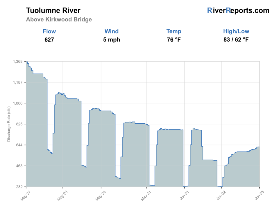
Flow observed
Not returned
Weather observed
5:00 PM UTC
Score calculated
5:27 PM UTC
Why this rating
Flow
Weather
Public alerts
Next 6-12 hours
Hold
Stable live data supports staying with the plan, but recheck the gauge and forecast before leaving.
Flow check
No live chart
Current trend: previous-score comparison will become more useful after repeated live checks.
More planning details: flies, flow bands, and live source checks
Fish it today
Start here
Groveland, Mather, or Hetch Hetchy approach is the practical base. Check riverreports chart, yosemite/forest notices, cdfw rules, road status, and release/weather changes, then pick a short legal access plan instead of trying to cover the whole river.
Best flow clue
Stable, clear, cool water with safe crossings and enough depth to hold trout in pockets.
Skip trigger
Skip during sharp rises, hot low water, unsafe crossings, or road and trail uncertainty.
Flow decision bands
Low but fishable
Low clear chart conditions may fish only when the bridge-area access, canyon exit, and rule checks are all confirmed.
Best canyon window
Stable or slowly falling chart trend with mild weather and open roads is the safest trout-planning signal.
Release or runoff unsafe
Rapid rises, release changes, or snowmelt-swollen canyon water should stop wading and crossings.
Road and bridge caution
The chart is useful, but road status, parking, and legal entry decide whether this reach is practical.
Flow check
No live chart
Current trend: previous-score comparison will become more useful after repeated live checks.
No structured live flow
Use the linked flow and access sources before deciding.
Live NWS forecast
79F / Mostly Sunny
Water temperature not verified
Heat guidance uses weather and river type unless an official water-temperature value is available.
No NWS alert flag
No active NWS alert was returned for this forecast point.
Use RiverReports for the public chart, then check the listed agency pages because no separate USGS numeric station was verified for this reach.
RiverReports chart, Yosemite/forest notices, CDFW rules, road status, and release/weather changes
This reach should be planned with official park, forest, and BLM access context because a flow chart alone does not prove safe or legal access.
Fast canyon water, steep exits, road closures, cold releases, and limited services
Editorial review
How this report is maintained
This report uses official regulation, flow, weather, access, and public-source material first, then adds practical angler planning guidance without replacing current rules.
Byline
BlueStreamFly editorial desk
Reviewed by
BlueStreamFly source review
Maintained by
BlueStreamFly
Last material review
2026-05-31
Report confidence
Good confidence
82/100
Good confidence: RiverReports chart support, Yosemite and CDFW rule sources, Stanislaus National Forest and BLM access context, and weather data support this reach page. Confidence is moderated by the lack of a separate official USGS source in the current page data, steep canyon access, release-sensitive water, and road status.
Regulations
Yosemite fishing information and CDFW inland guidance support the legal-check path for this reach.
Access
Stanislaus National Forest and BLM Tuolumne corridor sources support access context, with bridge parking, roads, and legal entry still needing current confirmation.
Flow and weather
RiverReports chart support and the National Weather Service point are attached, but this page does not currently include a separate official USGS source.
Fishing usefulness
The page now separates chart-based flow use, canyon access, release changes, road status, safe-bank decisions, and nearby alternatives.
Fishability dashboard and source review
2026-05-31 / material content or source review
RiverReports Tuolumne River above Kirkwood Bridge chart support, Yosemite fishing information, Stanislaus National Forest and BLM Tuolumne Wild and Scenic River access context, CDFW inland fishing information, and the National Weather Service point were checked before updating the current fishability guidance.
2026-05-31
Updated Tuolumne River above Kirkwood Bridge with chart-based canyon guidance, access cards, release and road cautions, backup cues, stable fishability SEO, and confidence signals.
2026-05-29
Added a page-specific report-confidence meter for Tuolumne above Kirkwood Bridge flow chart support, canyon access, regulation checks, weather, and conservative wading guidance.
2026-05-25
Published a new fishing report with flow, weather, hatch, fly, tactics, access, regulation, source, image-credit, and trip-planning sections.
Angler planning edge
Local details that change the plan
Best for
Sierra trout trips, Dry-dropper pocket water, Anglers who can hike and move carefully
Wade or float
Wade-and-move is the baseline. Float only where you have whitewater skill, legal access, and a safe takeout.
Best flows
Stable, clear, cool water with safe crossings and enough depth to hold trout in pockets.
When to skip
Skip during sharp rises, hot low water, unsafe crossings, or road and trail uncertainty.
Local plan
Groveland, Mather, or Hetch Hetchy approach is the practical base. Check riverreports chart, yosemite/forest notices, cdfw rules, road status, and release/weather changes, then pick a short legal access plan instead of trying to cover the whole river.
Pressure
Pressure concentrates near easy road pullouts, campgrounds, trailheads, and obvious pools.
Access nuance
This reach should be planned with official park, forest, and BLM access context because a flow chart alone does not prove safe or legal access.
Backup water
Check nearby BlueStreamFly reports if the gauge, rules, or weather do not fit the plan.
About the river
Setting, character, and why it fishes the way it does.
Tuolumne River above Kirkwood Bridge is a specific Tuolumne canyon reach where bridge access, regulated flows, and steep terrain require a conservative plan.
The best plan is built around safe flow, legal access, water temperature, and short realistic reaches instead of trying to cover the whole drainage.
This reach should be planned with official park, forest, and BLM access context because a flow chart alone does not prove safe or legal access.
Target species
Rainbow trout
Likely primary trout target where access and rules allow.
Brown trout
Possible in deeper canyon structure and lower-light windows.
Brook trout
Possible in upper connected waters; verify current rules.
Sensitive Sierra species
Avoid trampling shallow margins and spawning habitat.
Reading the water
Stable canyon flow
Best for careful pocket-water fishing from secure banks.
High or changing release
Treat as unsafe for casual wading.
Low clear water
Use small flies, stealth, and short casts.
Road-limited access
Do not count on a reach until road and parking status are current.
Best seasons
Late spring
Fish after snowmelt, release changes, or road conditions settle enough for safe access.
Summer
Best dry-dropper and attractor window, especially early and late before canyon heat builds.
Fall
Cooler nights, lower pressure, and stable water can create the cleanest trout fishing.
Winter
Specialized and access-dependent. Check roads, park or forest notices, and current rules.
Preferred flow source
Tuolumne River above Kirkwood Bridge
RiverReports is the preferred chart source when coverage exists. When a matching USGS gauge exists, keep it open as the official backstop for station data and current hydrograph context.
Weather
River weather report
Weather can change wading safety, road access, water temperature, hatches, and the best time of day to fish.
Live forecast loads as you reach this section
This keeps the report fast while still using the official National Weather Service forecast point.
Hatches and flies
Hatch chart and fly picks
Spring
Little stones, BWOs, caddis, and runoff-edge nymph movement
Stonefly nymph, BWO emerger, hare's ear, caddis pupa
Early summer
Caddis, PMDs, yellow sallies, and attractor dry-fly windows
Elk hair caddis, PMD emerger, yellow stimulator, perdigon
Late summer
Terrestrials, ants, beetles, hoppers, and evening caddis
Foam ant, beetle, hopper, X-caddis, parachute Adams
Fall
BWOs, midges, October caddis, and small streamer windows
BWO emerger, zebra midge, October caddis pupa, olive bugger
Dry-dropper flies
Stimulator, chubby, elk hair caddis, ant, beetle, pheasant tail, perdigon
Use in pocket water, riffles, and summer freestone lanes.
Nymphs
Stonefly nymph, hare's ear, caddis pupa, zebra midge, jig nymph
Use when cold water, bright sun, or fast seams keep trout down.
Streamers
Olive bugger, small sculpin, black leech, sparkle minnow
Use near deeper buckets, undercut banks, and slightly colored water.
Tactics
How to fish it
Start with a dry-dropper in broken water before adding weight.
Fish near-bank pockets first; canyon trout often hold closer than expected.
Use small streamers in deeper buckets or slightly colored water.
Move often and avoid wasting the best daylight on unsafe crossings.
Rigging
Rod, leader, and setup notes
A 4- or 5-weight with floating line covers most dry-dropper and nymph work.
Carry 4X to 6X for clear pocket water and stronger tippet for streamers.
Use compact rigs that can be changed quickly on rocky banks.
Pack a thermometer and stop trout fishing when water gets too warm.
Access
Access and planning notes
Kirkwood Bridge area
Reach and road checkWade / float / trail
Bridge / bank / short walk
When to pick it
Start here when the chart is steady and bridge-area access is clearly legal and open.
Caution
A bridge name does not guarantee safe parking or public bank access.
Early Intake and Mather context
Canyon stagingWade / float / trail
Road / trail / canyon scout
When to pick it
Use this when canyon logistics are more important than a quick roadside stop.
Caution
Remote exits, releases, and road conditions need day-of confirmation.
Stanislaus NF and BLM corridor
Public-land frameworkWade / float / trail
Forest road / trail / bank
When to pick it
Pick it when official public-land context and current conditions both support the plan.
Caution
Public-land context still requires posted-boundary and closure checks.
This reach should be planned with official park, forest, and BLM access context because a flow chart alone does not prove safe or legal access.
Confirm parking, land ownership, launch status, and current agency notices before relying on any access point.
Fast canyon water, steep exits, road closures, cold releases, and limited services
Regulations
Check before fishing
Check current CDFW inland trout regulations plus park, forest, or BLM notices before fishing. Rules can vary by reach and season.
Primary base
Groveland, Mather, or Hetch Hetchy approach
Best day style
Canyon road, trail, and whitewater-influenced access
Check first
RiverReports chart, Yosemite/forest notices, CDFW rules, road status, and release/weather changes
Safety
Fast canyon water, steep exits, road closures, cold releases, and limited services
Gear
Helpful gear for this water
4- or 5-weight rod
Enough for most trout presentations.
Wading staff
Useful on slick granite, cobble, and fast pocket water.
Thermometer
Protects trout during warm afternoons and low flows.
Layered pack
Canyon weather and exits can change the feel of the day.
Nearby water
Other water to research
Backup logic
High water
Move to a safer Tuolumne reach, Upper Truckee, North Fork Stanislaus, or wait for a lower chart trend.
Heat
Fish early and avoid forcing trout water when canyon temperatures and low flow stress fish.
Storms or runoff
Do not enter the canyon when thunderstorms, snowmelt, or release changes are likely.
Access issue
Use a better-documented public access point instead of improvising around bridge parking.
Tuolumne River
Broader high Sierra Tuolumne planning.
Tuolumne River below Hetch Hetchy
A downstream Hetch Hetchy reach-specific page.
Stanislaus River
A lower valley contrast with different access and species.
FAQ
Fast answers
Is Tuolumne River above Kirkwood Bridge fishable today?
Tuolumne River above Kirkwood Bridge is a cautious call right now. The live score is 69/100, based on current flow, weather, public alerts, and the report's planning context. Recheck the linked gauge and forecast before leaving because conditions can change quickly after rain, heat, access changes, or flow swings.
What flow is best for Tuolumne River above Kirkwood Bridge?
Stable, clear, cool water with safe crossings and enough depth to hold trout in pockets.
When should I skip Tuolumne River above Kirkwood Bridge?
Skip during sharp rises, hot low water, unsafe crossings, or road and trail uncertainty.
Is Tuolumne River above Kirkwood Bridge safe to wade right now?
The fishability score is not a wading guarantee. Wade only where your chosen access has safe edges, clear footing, legal entry, and no forced crossings; high, rising, stained, or storm-affected water should be treated conservatively.
Is Tuolumne River above Kirkwood Bridge usually open for fly fishing?
Check current CDFW rules and land-management notices first. This page gives planning context, but legal status comes from current rules.
Should I wade or float?
Wade-and-move is the baseline. Float only where you have whitewater skill, legal access, and a safe takeout.
Which flow source should I use?
Use the RiverReports chart for a fast read, then verify conditions with the listed park, forest, or water-management sources before fishing.
Sources
Source set for this report
Reviewed 2026-05-31