
California / West
Stanislaus River
Stanislaus River planning with RiverReports flow, official agency sources, NWS weather, access notes, hatch timing, fly picks, and practical safety guidance.
Image: Generated regional planning image for Stanislaus River / BlueStreamFly generated; not exact location / BlueStreamFlyFishability now: Stanislaus River fishability today
GoodData confidence: High80/100
Fishable now because Ripon gauge is rising, weather is mild, and no public alert is active.
Flow observed
3:45 PM UTC
Weather observed
4:00 PM UTC
Score calculated
4:20 PM UTC
Why this rating
Flow
Water temperature
Public alerts
Next 6-12 hours
Watch
Recheck within the next few hours; rising water or active weather can change clarity and wading quickly.
USGS flow
1,560 cfs
Current trend: flow rising, rating can drop quickly if clarity or wading safety deteriorates.
More planning details: flies, flow bands, and live source checks
Fish it today
Start here
Ripon, Oakdale, or Modesto is the practical base. Check usgs ripon flow, cdfw rules, park notices, water temperature, and launch status, then pick a short legal access plan instead of trying to cover the whole river.
Best flow clue
Stable flows with safe banks, workable clarity, and temperatures suited to the target species.
Skip trigger
Skip during muddy rises, unsafe bank conditions, hot low water, or unclear species rules.
Flow decision bands
Low but fishable
Low stable lower-river water may fish for warmwater targets, but bank access, heat, and reach-specific rules need checking.
Best lower-river window
Stable Ripon flow, mild weather, and a target-species plan that matches the season create the most useful setup.
Pushy or unsafe
High or rising lower-river flow can make banks, ramps, and side channels unsafe even when boating is possible.
Salmonid rule caution
Do not apply trout assumptions without checking the current CDFW table and migration-season context.
USGS flow
1,560 cfs
Current trend: flow rising, rating can drop quickly if clarity or wading safety deteriorates.
Live USGS flow
1,560 cfs / rising about 21%
Live NWS forecast
68F / Sunny
Live water temperature
58F from USGS
No NWS alert flag
No active NWS alert was returned for this forecast point.
Use RiverReports for a quick chart and USGS 11303000 for official flow context.
USGS Ripon flow, CDFW rules, park notices, water temperature, and launch status
Caswell Memorial State Park and USACE Stanislaus River Parks provide official lower-river access context, but each reach has its own parking, launch, and rule limits.
Lower-river current, wood, private banks, summer heat, and boat traffic
Editorial review
How this report is maintained
This report uses official regulation, flow, weather, access, and public-source material first, then adds practical angler planning guidance without replacing current rules.
Byline
BlueStreamFly editorial desk
Reviewed by
BlueStreamFly source review
Maintained by
BlueStreamFly
Last material review
2026-05-31
Report confidence
Moderate confidence
79/100
Moderate confidence: RiverReports, USGS Ripon flow, CDFW inland fishing information, Caswell Memorial State Park access details, boating-access context, and weather data support the page. Confidence is lower because the access source set is broader than a reach-by-reach fishery map and target species vary by season and reach.
Regulations
CDFW inland fishing information supports the rule-check path, but anglers still need current reach-specific tables before targeting salmonids or migration-season water.
Access
Caswell and state boating-access pages support the lower-river public framework, but parking, launch, and exact legal bank options still require day-of confirmation.
Flow and weather
RiverReports, USGS 11303000, and the National Weather Service point are attached to the route.
Fishing usefulness
The page now separates warmwater fit, lower-river flow, high-water bank risk, summer heat, park access, and backup choices.
Fishability dashboard and source review
2026-05-31 / material content or source review
RiverReports, USGS Stanislaus River at Ripon flow, CDFW inland fishing information, Caswell Memorial State Park access information, California boating-facility context, and the National Weather Service point were checked before updating the current fishability guidance.
2026-05-31
Updated Stanislaus River with Ripon trend guidance, lower-river target selection, park and boat access cards, backup cues, stable fishability SEO, and confidence signals.
2026-05-29
Added a page-specific report-confidence meter for Stanislaus River flow, regulation, park-and-boat access, weather, and lower-river warmwater planning guidance.
2026-05-25
Published a new fishing report with flow, weather, hatch, fly, tactics, access, regulation, source, image-credit, and trip-planning sections.
Angler planning edge
Local details that change the plan
Best for
Lower-river warmwater fly days, Short access sessions, Anglers who match species to temperature
Wade or float
Bank access and short wade plans are the baseline. Boat plans require current launches, safe flow, and a realistic takeout.
Best flows
Stable flows with safe banks, workable clarity, and temperatures suited to the target species.
When to skip
Skip during muddy rises, unsafe bank conditions, hot low water, or unclear species rules.
Local plan
Ripon, Oakdale, or Modesto is the practical base. Check usgs ripon flow, cdfw rules, park notices, water temperature, and launch status, then pick a short legal access plan instead of trying to cover the whole river.
Pressure
Pressure concentrates near parks, boat ramps, bridges, shaded banks, and summer recreation access.
Access nuance
Caswell Memorial State Park and USACE Stanislaus River Parks provide official lower-river access context, but each reach has its own parking, launch, and rule limits.
Backup water
Check nearby BlueStreamFly reports if the gauge, rules, or weather do not fit the plan.
About the river
Setting, character, and why it fishes the way it does.
Stanislaus River is a Central Valley river reach where park access, warmwater species, seasonal salmonid awareness, and flows below upstream dams shape the fly plan.
This is not a pure trout-stream plan. Use the gauge, current rules, temperature, and public access to decide whether warmwater, bass, or cautious salmonid scouting makes sense.
Caswell Memorial State Park and USACE Stanislaus River Parks provide official lower-river access context, but each reach has its own parking, launch, and rule limits.
Target species
Bass and panfish
Practical warm-season fly targets around wood, shade, and slower edges.
Striped bass
Possible in lower-river context; check current rules and local conditions.
Rainbow trout and steelhead context
Do not assume trout or salmonid opportunity without current rules and temperatures.
Chinook salmon
Migration and conservation context; do not target closed fish.
Reading the water
Stable lower-river flow
Best for bank access, poppers, streamers, and warmwater structure.
High release or storm water
Avoid unsafe banks and woody debris.
Hot summer water
Focus on warmwater species early and late.
Salmonid season context
Check rules before fishing trout-looking water or migration corridors.
Best seasons
Spring
Good for bass, panfish, and trout-or-salmonid scouting where rules, flows, and temperatures fit.
Summer
Think early, late, and warmwater tactics. Check temperatures before any trout or salmonid plan.
Fall
Cooling water can improve bass, stripers, and migration-season awareness, but rules still decide the target.
Winter
Use the gauge, current closures, and safe-bank access before choosing a lower-river fly day.
Preferred flow source
Stanislaus River at Ripon
RiverReports is the preferred chart source when coverage exists. When a matching USGS gauge exists, keep it open as the official backstop for station data and current hydrograph context.
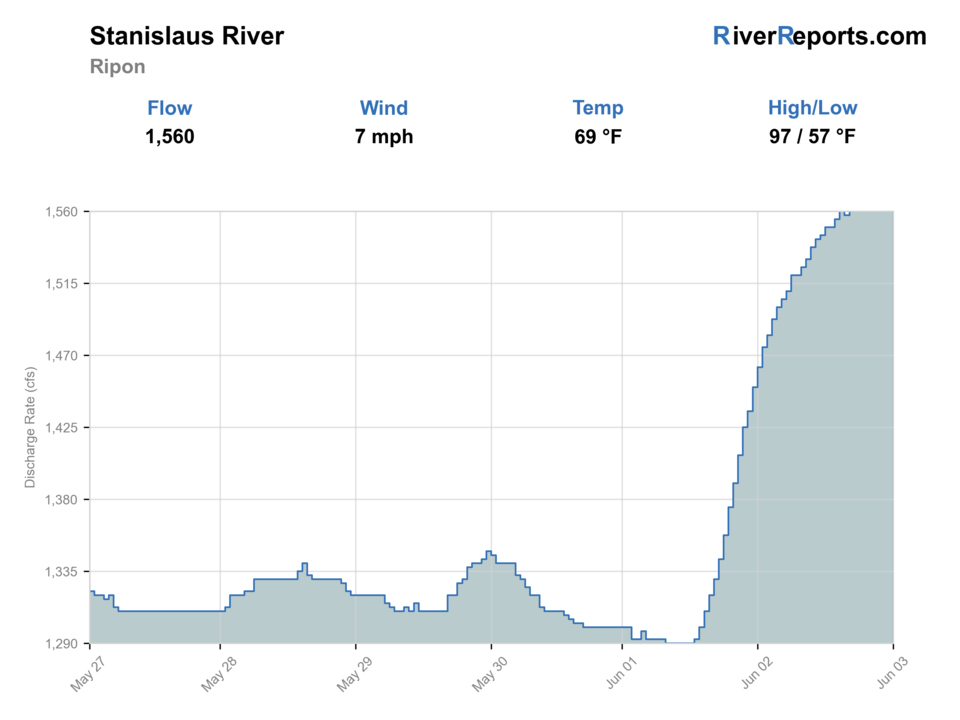
USGS data chart
Official USGS trend
Streamflow over the latest USGS reporting window.
Latest
1,560 cfs
Jun 3, 3 PM UTC
Weather
River weather report
Weather can change wading safety, road access, water temperature, hatches, and the best time of day to fish.
Live forecast loads as you reach this section
This keeps the report fast while still using the official National Weather Service forecast point.
Hatches and flies
Hatch chart and fly picks
Spring
Caddis, midges, small mayflies, baitfish, and crayfish movement
Soft hackle, caddis pupa, small clouser, crayfish, woolly bugger
Summer
Terrestrials, damselflies, baitfish, frogs, and warmwater forage
Foam bug, popper, damsel nymph, baitfish streamer, crayfish
Fall
Baitfish movement, caddis, olives, and cooling-water warmwater activity
Small streamer, soft hackle, crayfish, popper, BWO
Winter
Sparse midges and deeper-water forage
Midge, small bugger, leech, weighted nymph, slow baitfish
Warmwater search flies
Clouser, crayfish, small popper, woolly bugger, leech
Use around wood, shaded banks, current seams, and deeper summer slots.
Light nymphs and soft hackles
Caddis pupa, soft hackle, pheasant tail, zebra midge
Use when clear water or mixed species call for smaller flies.
Low-light streamers
Baitfish streamer, black bugger, olive bugger, small craw pattern
Use early, late, or when color gives fish cover.
Tactics
How to fish it
Start with bank cover, wood, and shade before fishing mid-channel water.
Use poppers or baitfish flies early and late when warmwater fish are active.
Switch to small soft hackles or nymphs when the water is clear and pressured.
Treat salmonid-looking water conservatively unless current rules and temperatures support it.
Rigging
Rod, leader, and setup notes
A 5- or 6-weight with floating line covers most lower-river fly work.
Carry small poppers, crayfish, baitfish flies, and soft hackles.
Use stronger tippet around wood, weeds, and warmwater structure.
Keep rigs simple so you can change targets without crowding the bank.
Access
Access and planning notes
Caswell Memorial State Park
Primary public park anchorWade / float / trail
Park / bank / lower-river scout
When to pick it
Use it when park access, flow, heat, and target species all fit.
Caution
Park access does not describe every downstream bank or private edge.
Ripon gauge corridor
Lower-river flow referenceWade / float / trail
Gauge / bank / ramp scout
When to pick it
Start here when the trend is stable and a lower-river target makes sense.
Caution
Warmwater, salmonid, and boating assumptions need separate checks.
State boating facilities
Boat and ramp planningWade / float / trail
Ramp / boat / bank support
When to pick it
Use it when wading is weak but a boat-supported lower-river day is realistic.
Caution
Ramp condition, flow, and private banks still need day-of confirmation.
Caswell Memorial State Park and USACE Stanislaus River Parks provide official lower-river access context, but each reach has its own parking, launch, and rule limits.
Confirm parking, land ownership, launch status, and current agency notices before relying on any access point.
Lower-river current, wood, private banks, summer heat, and boat traffic
Regulations
Check before fishing
Check current CDFW inland regulations, posted access rules, and any salmonid closures before fishing. Do not assume a lower-river reach is open for every species.
Primary base
Ripon, Oakdale, or Modesto
Best day style
Lower-river parks, boat access, warmwater edges, and salmonid-rule awareness
Check first
USGS Ripon flow, CDFW rules, park notices, water temperature, and launch status
Safety
Lower-river current, wood, private banks, summer heat, and boat traffic
Gear
Helpful gear for this water
5- or 6-weight rod
Useful for bass, panfish, and mixed lower-river fly work.
Floating line
Covers poppers, soft hackles, and light streamers.
Thermometer
Keeps trout or salmonid decisions honest.
Wading staff or bank shoes
Lower-river mud, wood, and cobble can be awkward.
Nearby water
Other water to research
Backup logic
High water
Avoid risky banks and compare the Tuolumne, Merced, or another lower-valley option after checking access.
Heat
Shift expectations toward warmwater targets or fish early instead of forcing trout-style handling.
Storms or stain
Let lower-river color and stage settle before committing to bank or ramp plans.
Access issue
Use park or state-listed access only; move to another river if legal bank access is unclear.
North Fork Stanislaus River near Avery
Higher Sierra trout and canyon planning.
Tuolumne River
High Sierra to canyon Tuolumne planning.
South Fork Tule River
A southern Sierra small-river trout plan.
FAQ
Fast answers
Is Stanislaus River fishable today?
Stanislaus River looks fishable right now. The live score is 80/100, based on current flow, weather, public alerts, and the report's planning context. Recheck the linked gauge and forecast before leaving because conditions can change quickly after rain, heat, access changes, or flow swings.
What flow is best for Stanislaus River?
Stable flows with safe banks, workable clarity, and temperatures suited to the target species.
When should I skip Stanislaus River?
Skip during muddy rises, unsafe bank conditions, hot low water, or unclear species rules.
Is Stanislaus River safe to wade right now?
The fishability score is not a wading guarantee. Wade only where your chosen access has safe edges, clear footing, legal entry, and no forced crossings; high, rising, stained, or storm-affected water should be treated conservatively.
Is Stanislaus River usually open for fly fishing?
Check current CDFW rules and land-management notices first. This page gives planning context, but legal status comes from current rules.
Should I wade or float?
Bank access and short wade plans are the baseline. Boat plans require current launches, safe flow, and a realistic takeout.
Which flow source should I use?
Use the RiverReports chart for a fast read and USGS 11303000 as the official flow source or context source.
Sources
Source set for this report
Reviewed 2026-05-31