
California / West
Merced River
A Merced River report for Yosemite-to-Briceburg planning, reach-specific regulations, spring runoff safety, BLM access, hatch timing, and practical flies.
Image: Merced River (8597240205) / CC BY 2.0 / Kylir Horton from Eagle Mountain, Utah, United StatesFishability now: Merced River fishability today
GoodData confidence: High72/100
Fishable now because Happy Isles Bridge gauge is rising, weather is usable, and no public alert is active.
Flow observed
3:30 PM UTC
Weather observed
4:00 PM UTC
Score calculated
4:20 PM UTC
Why this rating
Flow
Water temperature
Public alerts
Next 6-12 hours
Watch
Recheck within the next few hours; rising water or active weather can change clarity and wading quickly.
USGS flow
806 cfs
Current trend: flow rising, rating can drop quickly if clarity or wading safety deteriorates.
More planning details: flies, flow bands, and live source checks
Fish it today
Start here
Choose Yosemite if you want cooler scenery-driven pocket water and can work within park rules, or choose the Briceburg corridor if you want BLM canyon access and accept the hotter, more exposed lower-canyon day. Fish one reach with purpose instead of driving the whole drainage in search of a generic Merced answer.
Best flow clue
Use the upper-river trend as a warning system more than as a magic target. Once runoff begins to settle, pocket water and softer edges become worth the effort; when snowmelt is still pushing hard or the lower canyon is baking in heat, the best move is often to wait or switch rivers.
Skip trigger
Skip the Merced during hard spring runoff, when Yosemite or Briceburg access is restricted, when canyon heat makes trout handling suspect, or when you have not sorted out whether park rules or lower-river regulations apply to your exact destination.
Flow decision bands
Low but fishable
Low clear summer flow can fish with careful trout handling, long leaders, and shade-line presentations when the reach is legal.
Best reach-matched window
Stable or gently falling Happy Isles flow, safe canyon edges, and current Yosemite/CDFW rules create the cleanest trout plan.
Runoff or unsafe
High snowmelt, cold pushy water, or limited exits should end wading plans even when weather feels warm.
Reach-rule caution
Yosemite, Briceburg, and lower Merced reaches need separate rule and access checks before fishing.
USGS flow
806 cfs
Current trend: flow rising, rating can drop quickly if clarity or wading safety deteriorates.
Live USGS flow
806 cfs / rising about 42%
Live NWS forecast
73F / Mostly Sunny
Live water temperature
52F from USGS
No NWS alert flag
No active NWS alert was returned for this forecast point.
Use the Happy Isles or Pohono/Briceburg flow context for the reach you plan to fish.
Check Yosemite rules separately from CDFW lower-river regulations.
Spring runoff can make wading unsafe even when the weather is warm.
BLM Briceburg-area access is useful, but roads, camping rules, and heat matter.
Editorial review
How this report is maintained
This Merced River report is maintained from current Yosemite, BLM, flow, weather, and regulation sources so anglers can separate park water, canyon water, and lower-river habitat context before they start tying knots.
Byline
BlueStreamFly editorial team
Reviewed by
BlueStreamFly source review
Maintained by
Mountain Brook Run LLC
Last material review
2026-05-31
Report confidence
Good confidence
87/100
Good confidence: RiverReports, USGS Happy Isles flow, Yosemite hydrology, BLM access, CDFW regulation and habitat sources, and weather data support the page. Confidence is moderated by reach complexity, runoff timing, heat, park-versus-CDFW rules, and lower-river habitat boundaries.
Regulations
CDFW Title 14 and Yosemite-rule context support the legal-check path, with exact reach boundaries still requiring current review.
Access
BLM Merced River and Yosemite context support the main public planning anchors, but exact roads, park access, and lower-river boundaries need day-of checks.
Flow and weather
RiverReports, USGS 11264500, Yosemite hydrology context, and the National Weather Service point are attached to the route.
Fishing usefulness
The page now separates Yosemite, Briceburg, lower Merced habitat, runoff safety, heat, and backup-water choices.
Fishability dashboard and source review
2026-05-31 / material content or source review
RiverReports, USGS Happy Isles flow, Yosemite hydrology context, BLM Merced River access, CDFW regulation and Merced habitat sources, and the National Weather Service point were checked before updating the current-fishability decision layer.
2026-05-31
Updated Merced River to the current fishability-page standard with reach-first Yosemite and Briceburg flow guidance, access cards, backup cues, stable fishability SEO, and confidence signals.
2026-05-29
Added a page-specific report-confidence meter for Yosemite, Briceburg, flow, regulation, weather, access, and runoff-sensitive Merced River planning.
2026-05-28
Added reach-specific trip-fit guidance, wade-first runoff framing, Yosemite and Briceburg access nuance, pressure timing, backup-water suggestions, and stronger editorial review signals after source review.
Angler planning edge
Local details that change the plan
Best for
Anglers who will choose between Yosemite water and the Briceburg canyon before they leave home, Freestone trout days once runoff drops enough to make pocket water and soft edges realistic, Trips where scenery matters, but safety and legal access still stay ahead of the hatch chart, Sierra travel days that need an official fallback when the Merced is too high or too hot
Wade or float
Treat the Merced as a wade-first river with separate park and canyon personalities. The upper river in Yosemite and the Briceburg corridor are both better approached as targeted walk-and-wade days than as general float water, especially when spring runoff or summer traffic is part of the equation.
Best flows
Use the upper-river trend as a warning system more than as a magic target. Once runoff begins to settle, pocket water and softer edges become worth the effort; when snowmelt is still pushing hard or the lower canyon is baking in heat, the best move is often to wait or switch rivers.
When to skip
Skip the Merced during hard spring runoff, when Yosemite or Briceburg access is restricted, when canyon heat makes trout handling suspect, or when you have not sorted out whether park rules or lower-river regulations apply to your exact destination.
Local plan
Choose Yosemite if you want cooler scenery-driven pocket water and can work within park rules, or choose the Briceburg corridor if you want BLM canyon access and accept the hotter, more exposed lower-canyon day. Fish one reach with purpose instead of driving the whole drainage in search of a generic Merced answer.
Pressure
Yosemite visibility and Highway 140 convenience can concentrate recreation pressure even when dedicated anglers are spread out. Early starts and weekday visits usually create better room than trying to force a famous roadside stop late in the morning.
Access nuance
The Merced changes land managers quickly. Yosemite rules apply in the park, BLM manages key Briceburg recreation access downstream, and lower-river habitat and regulation context are not interchangeable with upper-river trout assumptions.
Backup water
If the Merced is too high, too hot, or too crowded, pivot to Hot Creek for a technical spring-creek day or to the San Joaquin if another reach-aware Sierra freestone plan fits the travel window better.
About the river
Setting, character, and why it fishes the way it does.
The Merced River begins in the Sierra Nevada, flows through Yosemite National Park, cuts west through the Merced River canyon, and eventually reaches the San Joaquin Valley.
Yosemite's Merced is a scenic freestone system shaped by snowpack and runoff, with different planning needs than the lower river below major dams and bridges.
The BLM Merced River Recreation Management Area near Briceburg provides important public access, camping, trails, and canyon trip logistics.
CDFW has documented lower Merced drought and steelhead habitat work, which is why lower-river anadromous rules should not be blended with high-country trout assumptions.
Target species
Rainbow trout
A main trout target in appropriate upper and canyon reaches when rules and temperatures allow.
Brown trout
Present in parts of the system, especially around deeper pools and undercut cover.
Steelhead and fall-run Chinook
Relevant to lower-river habitat and regulations. Do not target or handle protected fish outside current rules.
Warmwater species
Lower valley reaches can shift away from classic trout fly fishing as water warms.
Reading the water
Low clear summer flow
Use stealth, long leaders, small dries, and shade-line presentations. Watch temperature.
Stable spring flow
Nymph edges, softer pockets, and side channels while staying out of dangerous main current.
High runoff
Skip wading. The river can be cold, powerful, and unforgiving during snowmelt.
Hot lower canyon
Fish early, carry water, and stop trout fishing if temperatures or handling conditions are poor.
Best seasons
Spring
Runoff is the deciding factor. Fish only safe edges and smaller windows when flows allow.
Early summer
Post-peak runoff can open useful trout and hatch windows, especially in cooler reaches.
Late summer
Clear water and terrestrials can work, but heat and low water can limit ethical trout fishing.
Fall
Cooler weather improves the plan, but lower-river anadromous rules remain reach-specific.
Preferred flow source
Merced River at Happy Isles Bridge
RiverReports is the preferred chart source when coverage exists. When a matching USGS gauge exists, keep it open as the official backstop for station data and current hydrograph context.
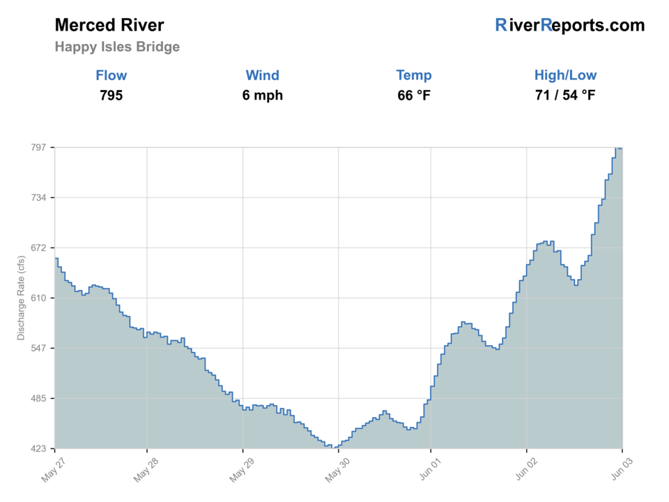
USGS data chart
Official USGS trend
Streamflow over the latest USGS reporting window.
Latest
806 cfs
Jun 3, 4 PM UTC
Weather
River weather report
Weather can change wading safety, road access, water temperature, hatches, and the best time of day to fish.
Live forecast loads as you reach this section
This keeps the report fast while still using the official National Weather Service forecast point.
Hatches and flies
Hatch chart and fly picks
Spring
BWOs, March browns, caddis, stoneflies
BWO emerger, March brown, caddis pupa, stonefly nymph
Early summer
PMDs, caddis, yellow sallies, golden stones
PMD dry, elk hair caddis, stimulator, yellow sally nymph
Summer
Caddis, terrestrials, small mayflies
Ant, beetle, caddis dry, parachute mayfly, small nymph
Fall
BWOs, midges, October caddis
BWO, zebra midge, October caddis, soft hackle
Dry-dropper
Stimulator, parachute mayfly, caddis dry, perdigon, pheasant tail
Use in pocket water and softer canyon edges after runoff begins to drop.
Nymphs
Stonefly, pheasant tail, hare's ear, caddis pupa, zebra midge
Use when flows are up but edges and pockets are safe to fish.
Terrestrials
Ant, beetle, hopper, small foam attractor
Use in late summer and fall along brushy banks and shaded lanes.
Streamers
Sculpin, olive bugger, small baitfish, leech
Use in deeper pools, stained water, or low-light canyon conditions.
Tactics
How to fish it
Choose Yosemite, Briceburg/canyon, or lower-river habitat before applying any rule summary.
Use the nearest relevant gauge instead of reading one flow number for the whole river.
During runoff, fish from the bank and avoid crossings.
Look for trout in soft edges, plunge-pool lips, and shaded pocket water.
Carry extra water and sun protection in the canyon.
If you see spawning fish or redds, move on and protect the habitat.
Rigging
Rod, leader, and setup notes
A 9-foot 4-weight or 5-weight covers most trout work.
Use a dry-dropper rig in pocket water once flows are reasonable.
Carry heavier nymph rigs for high but safe edge water.
Use 4X to 6X tippet depending on clarity and fly size.
Bring traction, a thermometer, and a runoff backup plan.
Access
Access and planning notes
Yosemite Valley / Happy Isles
Upper-river flow and park-rule checkWade / float / trail
Park / bank / short wade
When to pick it
Start here when NPS access, current rules, and upper-river flow match the plan.
Caution
Park rules and lower-river CDFW rules are not interchangeable.
Briceburg and BLM canyon
Canyon access baseWade / float / trail
Road / campground / bank
When to pick it
Use it when BLM access, heat, roads, and flow all support a safe canyon session.
Caution
Highway pullouts, summer heat, and cold runoff leave little margin.
Lower Merced habitat reaches
Rule boundary awarenessWade / float / trail
Regulation / habitat context
When to pick it
Use this context when lower-river species or closures may change the plan.
Caution
Do not blend lower salmonid rules with Yosemite trout assumptions.
Yosemite National Park rules and CDFW rules are not interchangeable.
Briceburg Road and canyon recreation sites can have closures, reservations, or seasonal issues.
Highway 140 traffic and narrow pullouts require careful parking choices.
Spring water is cold and powerful; do not wade because the air feels warm.
Lower-river steelhead and salmon habitat should be treated carefully and checked against current rules.
Regulations
Check before fishing
Verify CDFW reach-specific Merced River regulations and Yosemite National Park fishing rules before fishing. Rules differ by dam, bridge, park, and lower-river boundary.
Primary base
Yosemite Valley, El Portal, Mariposa, or Merced, California
Best day style
Yosemite rules, highway canyon access, and BLM recreation sites
Check first
Reach-specific CDFW rules, Yosemite rules, flow, runoff, road status
Safety
Cold spring runoff, slick canyon rocks, heat, limited exits, highway traffic
Gear
Helpful gear for this water
Runoff safety kit
Traction, wading staff, and conservative judgment are more important than a perfect fly box in spring.
Dry-dropper box
Useful for canyon pocket water once flows drop into a safer range.
Sun and water
The lower canyon can be hot, exposed, and dry.
Park and BLM planning links
Rules, access, and road status can change by land manager.
Nearby water
Other water to research
Backup logic
High water
Wait for runoff to drop or compare Hot Creek, East Walker, or a safer Sierra option.
Heat
Fish early, carry water, and stop trout fishing when canyon temperatures or water temps become stressful.
Storms or road issues
Check Yosemite, BLM, and weather sources before entering the canyon.
Access issue
Move to another signed public reach rather than guessing at park, BLM, or private boundaries.
San Joaquin River
Another Sierra river where the useful fly plan depends heavily on reach selection.
Kings River
A separate Sierra report with canyon, reservoir, and tailwater planning differences.
Hot Creek
A very different Eastern Sierra spring-creek option when runoff makes freestone rivers hard.
FAQ
Fast answers
Is Merced River fishable today?
Merced River looks fishable right now. The live score is 72/100, based on current flow, weather, public alerts, and the report's planning context. Recheck the linked gauge and forecast before leaving because conditions can change quickly after rain, heat, access changes, or flow swings.
What flow is best for Merced River?
Use the upper-river trend as a warning system more than as a magic target. Once runoff begins to settle, pocket water and softer edges become worth the effort; when snowmelt is still pushing hard or the lower canyon is baking in heat, the best move is often to wait or switch rivers.
When should I skip Merced River?
Skip the Merced during hard spring runoff, when Yosemite or Briceburg access is restricted, when canyon heat makes trout handling suspect, or when you have not sorted out whether park rules or lower-river regulations apply to your exact destination.
Is Merced River safe to wade right now?
The fishability score is not a wading guarantee. Wade only where your chosen access has safe edges, clear footing, legal entry, and no forced crossings; high, rising, stained, or storm-affected water should be treated conservatively.
What Merced River reach is best for fly fishing?
It depends on season and rules. Yosemite and Briceburg/canyon reaches are the main trout-planning anchors, while lower reaches have different anadromous regulations.
What gauge should I check?
Use Happy Isles, Pohono, or other Merced gauges that match your reach. This page displays the RiverReports Happy Isles gauge for upper-river context.
Is spring runoff dangerous?
Yes. The Merced can be cold, fast, and unsafe to wade during runoff even on warm days.
Can I use the same rules in Yosemite and below the park?
No. Check Yosemite National Park rules and CDFW reach-specific rules separately.
Sources
Source set for this report
Reviewed 2026-05-31