
California / West
Mad River at Arcata
Mad River at Arcata planning with RiverReports flow, official USGS backing, CDFW regulation checks, NWS weather, access notes, hatch timing, fly picks, and practical safety guidance.
Image: Generated regional planning image for Mad River at Arcata / BlueStreamFly generated; not exact location / BlueStreamFlyFishability now: Mad River at Arcata fishability today
GreatData confidence: High96/100
Fishable now because Arcata gauge is stable, weather is mild, and no public alert is active.
Flow observed
3:45 PM UTC
Weather observed
4:00 PM UTC
Score calculated
4:20 PM UTC
Why this rating
Flow
Weather
Public alerts
Next 6-12 hours
Hold
Stable live data supports staying with the plan, but recheck the gauge and forecast before leaving.
USGS flow
117 cfs
Current trend: flow stable, so weather, temperature, and access checks drive the next change.
More planning details: flies, flow bands, and live source checks
Fish it today
Start here
Start with Mad River Beach County Park if you want the clearest lower-river public anchor, then decide whether the day stays lower, shifts upstream toward the hatchery corridor, or gets scrapped entirely based on color, weather, and the first legal access you can actually fish well.
Best flow clue
Use the Arcata trend together with coastal weather and river color, not by itself. The best windows come when the river is open under low-flow rules, visibility is returning after rain, and the lower river still has enough shape to hold fish without becoming a dirty tide-influenced gamble.
Skip trigger
Skip the lower Mad when low-flow closure status is unclear, when surf or coastal storms push dirty water back into the lower river, when bank footing around the county-park corridor is unsafe, or when private-boundary or launch access questions are still unresolved at the first stop.
Flow decision bands
Open and fishable
CDFW open status, a clearing Arcata gauge trend, safe lower-river access, and manageable coastal weather must all line up.
Best lower-river window
Falling post-rain flow with improved visibility supports lower-river steelhead searching when access is legal.
Tide or surf caution
Wind, surf, tide-adjacent water, and soft banks can make the lower river a poor choice even when the gauge looks usable.
Closure hard stop
Low-flow closure status and current salmonid rules override any fishability score.
USGS flow
117 cfs
Current trend: flow stable, so weather, temperature, and access checks drive the next change.
Live USGS flow
117 cfs / stable
Live NWS forecast
53F / Partly Sunny
Water temperature not verified
Heat guidance uses weather and river type unless an official water-temperature value is available.
No NWS alert flag
No active NWS alert was returned for this forecast point.
Use RiverReports for a quick chart and 11481000 for official USGS context.
CDFW low-flow status, lower-river gauge, county access, tide/weather, and rain trend
Humboldt County lists Mad River Beach County Park with beach, dune, Mad River, and boat-ramp access, which makes it useful for lower-river planning.
Carry a valid California license and steelhead report card when the target requires it.
Editorial review
How this report is maintained
This lower Mad River report is maintained from current low-flow regulation, county-access, flow, weather, and public-source checks so anglers can plan the Arcata and Mad River Beach corridor without overstating lower-river access certainty.
Byline
BlueStreamFly editorial team
Reviewed by
BlueStreamFly source review
Maintained by
Mountain Brook Run LLC
Last material review
2026-05-31
Report confidence
Good confidence
85/100
Good confidence: RiverReports, USGS Arcata flow, CDFW low-flow and steelhead sources, Humboldt County access context, hatchery context, and weather data support the page. Confidence is moderated by tide-adjacent lower water, coastal weather, soft banks, low-flow closures, and partial access certainty.
Regulations
CDFW low-flow and steelhead-card sources support the legal-check path.
Access
Humboldt County park/access and CDFW hatchery sources support planning, while lower-river banks and tide/surf conditions need current checks.
Flow and weather
RiverReports, USGS 11481000, and the National Weather Service point are attached to the route.
Fishing usefulness
The page now separates lower-river flow, low-flow closure status, coastal weather, access boundaries, and backup choices.
Fishability dashboard and source review
2026-05-31 / material content or source review
RiverReports, USGS Mad River at Arcata flow, CDFW low-flow and steelhead-report-card sources, Humboldt County parks/access information, CDFW Mad River Hatchery context, and the National Weather Service point were checked before updating the current-fishability decision layer.
2026-05-31
Updated Mad River at Arcata to the current fishability-page standard with lower-river flow guidance, county access cards, tide/coastal cautions, backup cues, stable fishability SEO, and confidence signals.
2026-05-28
Refined the Arcata trip-fit guidance with county-park access nuance, tide-and-storm skip cues, lower-river pressure timing, stronger editorial review signals, and a page-specific report-confidence meter after source review.
2026-05-25
Initial source-reviewed report published with flow, weather, hatches, flies, tactics, access, regulations, and planning sections.
Angler planning edge
Local details that change the plan
Best for
North Coast anglers who want a lower-river or near-mouth Mad plan with county-park access anchors, Short legal sessions built around lower-river clarity, tide-adjacent weather, and an open low-flow window, Travelers who need a separate lower-river page instead of assuming the Blue Lake hatchery corridor fishes the same way, Coastal days where you are willing to back off quickly if weather, surf, or turbidity make the lower river a poor salmonid choice
Wade or float
Treat the lower Mad at Arcata as a cautious bank-first page with selective boat-ramp context rather than a promise of easy broad lower-river coverage. The practical public plan is to work from county-park or other confirmed legal access and leave once weather, tide, or clarity stop fitting a steelhead-style day.
Best flows
Use the Arcata trend together with coastal weather and river color, not by itself. The best windows come when the river is open under low-flow rules, visibility is returning after rain, and the lower river still has enough shape to hold fish without becoming a dirty tide-influenced gamble.
When to skip
Skip the lower Mad when low-flow closure status is unclear, when surf or coastal storms push dirty water back into the lower river, when bank footing around the county-park corridor is unsafe, or when private-boundary or launch access questions are still unresolved at the first stop.
Local plan
Start with Mad River Beach County Park if you want the clearest lower-river public anchor, then decide whether the day stays lower, shifts upstream toward the hatchery corridor, or gets scrapped entirely based on color, weather, and the first legal access you can actually fish well.
Pressure
Pressure is lighter than at the hatchery corridor most days, but it concentrates fast when the lower river finally clears after a storm and the obvious county access is fishing. Early starts and quick reality checks matter more than covering miles.
Access nuance
County-park access is useful, but lower-river banks, launch areas, and nearby bridges still mix public and uncertain ground. The page is strongest when you treat Mad River Beach as the anchor and expand only after confirming the next stop.
Backup water
If the lower Mad is too dirty, tide-affected, or access-limited, move upstream to the Mad River page near Blue Lake only when that corridor is the cleaner legal fit, or pivot to the Eel when the bigger North Coast gauge is dropping into shape first.
About the river
Setting, character, and why it fishes the way it does.
Mad River at Arcata is the lower coastal end of the Mad River, where steelhead timing, county-park access, beach conditions, and low-flow rules all shape the plan.
For fly anglers, the value is in timing. These coastal systems can be excellent when open, cool, and clearing, but they are also built around salmonid conservation, private-land edges, and seasonal closures.
Humboldt County lists Mad River Beach County Park with beach, dune, Mad River, and boat-ramp access, which makes it useful for lower-river planning.
Target species
Steelhead
Primary legal-season fly target when CDFW low-flow status and lower-river conditions are favorable.
Surfperch and estuary fish
More relevant near beach and lower-river access than in upstream hatchery water.
Coho and Chinook salmon
Conservation-sensitive; do not target closed salmonids.
Resident trout
Secondary to the lower-river salmonid and estuary context.
Reading the water
Open and clearing lower flow
Best for lower-river steelhead searching when visibility and access are safe.
Tide and surf weather
Check coastal wind, surf, and tide context before choosing lower-river access.
Low-flow closure period
Follow CDFW updates; do not fish closed water.
Post-storm turbidity
Wait for safer footing and clearer lanes.
Best seasons
September to April
Low-flow rules can open or close North Coast salmonid water during this period. Check CDFW before planning a steelhead or salmonid day.
Winter
Main steelhead window when flows are legal, dropping, and clearing. Storm timing matters more than calendar date.
Spring
Useful for post-storm clarity, careful trout or half-pounder style searching where legal, and lower-pressure scouting.
Summer
Often more of a scouting, warmwater, surf, or estuary-adjacent planning season than a trout or steelhead season.
Preferred flow source
Mad River at Arcata
RiverReports is the preferred chart source when coverage exists. When a matching USGS gauge exists, keep it open as the official backstop for station data and current hydrograph context.
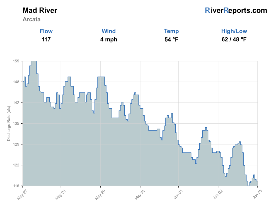
USGS data chart
Official USGS trend
Streamflow over the latest USGS reporting window.
Latest
117 cfs
Jun 3, 3 PM UTC
Weather
River weather report
Weather can change wading safety, road access, water temperature, hatches, and the best time of day to fish.
Live forecast loads as you reach this section
This keeps the report fast while still using the official National Weather Service forecast point.
Hatches and flies
Hatch chart and fly picks
Winter
Sparse midges, winter stones, salmonid eggs where legal, and baitfish movement
Small black stone, egg pattern where legal, soft hackle, black leech, small baitfish
Spring
BWOs, caddis, small mayflies, sculpins, and fry movement
BWO emerger, caddis pupa, soft hackle, sculpin, small clouser
Summer
Terrestrials, caddis, midges, warmwater forage, and estuary bait
Foam ant, small caddis, popper, baitfish streamer, crayfish
Fall
First rain pulses, small olives, caddis, and salmonid migration cues
Soft hackle, BWO, small streamer, muddler, sparse steelhead wet fly
Steelhead and salmonid flies
Sparse wet fly, black leech, egg pattern where legal, muddler, small intruder, soft hackle
Use only when the river is open, flows are legal, and the reach supports a salmonid plan.
Search streamers
Sculpin, clouser, olive bugger, black bugger, small baitfish
Use on clearing flows, deeper bends, shaded cutbanks, and estuary-influenced water.
Light-water flies
BWO emerger, caddis pupa, soft hackle, small nymph, foam ant
Use in smaller legal water, soft edges, or when clear low flows demand a subtle presentation.
Tactics
How to fish it
Check open status before leaving home, then match the gauge to clarity when you arrive.
Swing sparse flies or small streamers through soft traveling lanes only when the river is legal and fishable.
Avoid redds, staging fish, and crowded slots; these rivers depend on careful handling.
Keep a backup plan because coastal rivers can close or blow out quickly.
Rigging
Rod, leader, and setup notes
A 7- or 8-weight is appropriate for legal winter steelhead work; lighter rods fit trout or smaller water only where legal.
Carry floating and light sink-tip options, sparse wet flies, leeches, and small baitfish patterns.
Use barbless hooks and quick releases for wild salmonids.
Bring rain gear, a wading staff, and a backup plan for closures or dirty water.
Access
Access and planning notes
Mad River Beach County Park
Lower-river access frameWade / float / trail
Beach / lower river / boat ramp
When to pick it
Use it when coastal weather, river level, and legal status support lower-river planning.
Caution
Beach access, surf conditions, and river access are separate safety checks.
Lower Mad River bridge orbit
Bank scoutWade / float / trail
Bridge / bank / short wade
When to pick it
Pick it only when parking and private-boundary questions are resolved.
Caution
Lower bars and soft banks shift after storms.
Mad River Hatchery comparison
Upstream fallbackWade / float / trail
Bank / hatchery access
When to pick it
Compare it when the lower river is too tide-influenced or stormy.
Caution
Hatchery-area pressure and rules still apply.
Humboldt County lists Mad River Beach County Park with beach, dune, Mad River, and boat-ramp access, which makes it useful for lower-river planning.
Confirm parking, land ownership, and current agency notices before relying on any access point.
Tide-influenced lower water, surf-zone weather, soft banks, cold water, and private-land edges
Regulations
Check before fishing
Check CDFW low-flow rules, current sport fishing regulations, and steelhead report-card requirements before fishing. Open status can change during the season.
Primary base
Arcata, McKinleyville, or Blue Lake
Best day style
Lower river, beach/boat access, and tide-adjacent planning
Check first
CDFW low-flow status, lower-river gauge, county access, tide/weather, and rain trend
Safety
Tide-influenced lower water, surf-zone weather, soft banks, cold water, and private-land edges
Gear
Helpful gear for this water
7- or 8-weight rod
Appropriate for legal winter steelhead water and bigger coastal flows.
Sink-tip option
Useful for deeper traveling lanes and post-storm color.
Steelhead card
Required when fishing for steelhead in California anadromous waters.
Rain and safety kit
Coastal storms, cold water, and remote bars require conservative packing.
Nearby water
Other water to research
Backup logic
High water
Wait for a lower clearing trend or compare upstream Mad River and Eel River options.
Heat
Avoid stressing salmonids in warm low water and move to a colder or different target.
Coastal storms or surf
Skip lower-river bars until wind, surf, and visibility improve.
Access issue
Use county-listed access or choose another river rather than guessing at lower-river banks.
Mad River
Blue Lake and hatchery-area planning upstream.
Noyo River
Another coastal river with low-flow rules and lower-river access.
Eel River
A larger North Coast salmonid system.
FAQ
Fast answers
Is Mad River at Arcata fishable today?
Mad River at Arcata looks very fishable right now. The live score is 96/100, based on current flow, weather, public alerts, and the report's planning context. Recheck the linked gauge and forecast before leaving because conditions can change quickly after rain, heat, access changes, or flow swings.
What flow is best for Mad River at Arcata?
Use the Arcata trend together with coastal weather and river color, not by itself. The best windows come when the river is open under low-flow rules, visibility is returning after rain, and the lower river still has enough shape to hold fish without becoming a dirty tide-influenced gamble.
When should I skip Mad River at Arcata?
Skip the lower Mad when low-flow closure status is unclear, when surf or coastal storms push dirty water back into the lower river, when bank footing around the county-park corridor is unsafe, or when private-boundary or launch access questions are still unresolved at the first stop.
Is Mad River at Arcata safe to wade right now?
The fishability score is not a wading guarantee. Wade only where your chosen access has safe edges, clear footing, legal entry, and no forced crossings; high, rising, stained, or storm-affected water should be treated conservatively.
Is Mad River at Arcata usually open for fly fishing?
Do not assume it is open. North Coast low-flow rules and salmonid protections can close these waters when flows are too low or conditions are stressful.
Should I wade or float?
Wading from legal access is usually the safer planning baseline. Floating requires current local access knowledge, safe flow, and a realistic takeout.
Which flow source should I use?
Use the RiverReports chart for a fast read and USGS 11481000 as the official flow source or context source.
Sources
Source set for this report
Reviewed 2026-05-31