
California / West
Noyo River
Noyo River planning with RiverReports flow, official USGS backing, CDFW regulation checks, NWS weather, access notes, hatch timing, fly picks, and practical safety guidance.
Image: Generated regional planning image for Noyo River / BlueStreamFly generated; not exact location / BlueStreamFlyFishability now: Noyo River fishability today
GreatData confidence: High91/100
Fishable now because the live gauge is stable, weather is mild, and no public alert is active.
Flow observed
4:15 PM UTC
Weather observed
5:00 PM UTC
Score calculated
5:24 PM UTC
Why this rating
Flow
Weather
Public alerts
Next 6-12 hours
Hold
Stable live data supports staying with the plan, but recheck the gauge and forecast before leaving.
USGS flow
23 cfs
Current trend: flow stable, so weather, temperature, and access checks drive the next change.
More planning details: flies, flow bands, and live source checks
Fish it today
Start here
Fort Bragg is the practical base. Check cdfw low-flow status, usgs noyo flow, harbor access, coastal weather, and tide/wind, then pick a short legal access plan instead of trying to cover the whole river.
Best flow clue
Open under CDFW low-flow rules, dropping after rain, and clear enough to fish without stressing salmonids.
Skip trigger
Skip during closures, muddy storm spikes, hot low water, or when access depends on private-land assumptions.
Flow decision bands
Low but fishable / open
CDFW low-flow open status, a clearing Noyo gauge trend, legal access, cold water, and safe coastal weather need to line up.
Best lower-river window
Falling post-rain flow with improved visibility supports careful winter salmonid searching.
Tide, harbor, or storm caution
Wind, tide-adjacent water, harbor traffic, and storm runoff can make the lower river a poor plan.
Closure hard stop
Low-flow closure status overrides the score, fly choice, and access plan.
USGS flow
23 cfs
Current trend: flow stable, so weather, temperature, and access checks drive the next change.
Live USGS flow
23 cfs / stable
Live NWS forecast
59F / Sunny
Water temperature not verified
Heat guidance uses weather and river type unless an official water-temperature value is available.
No NWS alert flag
No active NWS alert was returned for this forecast point.
Use RiverReports for a quick chart and 11468500 for official USGS context.
CDFW low-flow status, USGS Noyo flow, harbor access, coastal weather, and tide/wind
California State Parks boating facility records identify Noyo River public facilities, but anglers should separate harbor access from upstream fishing access and land status.
Carry a valid California license and steelhead report card when the target requires it.
Editorial review
How this report is maintained
This report uses official regulation, flow, weather, access, and public-source material first, then adds practical angler planning guidance without replacing current rules.
Byline
BlueStreamFly editorial desk
Reviewed by
BlueStreamFly source review
Maintained by
BlueStreamFly
Last material review
2026-05-31
Report confidence
Good confidence
83/100
Good confidence: RiverReports, USGS Noyo flow, CDFW low-flow and steelhead sources, North Coast salmonid context, Noyo lower-river access context, and weather data support the page. Confidence is moderated by boating-oriented access sources, private-land edges, low-flow closures, coastal storms, and generated regional imagery.
Regulations
CDFW low-flow and steelhead-card sources support the legal-check path.
Access
Noyo lower-river and boating access sources are useful context, but exact legal fishing banks need current confirmation.
Flow and weather
RiverReports, USGS 11468500, and the National Weather Service point are attached to the route.
Fishing usefulness
The page now separates low-flow closure status, harbor/lower-river access, storm color, tide/wind caution, and backup choices.
Fishability dashboard and source review
2026-05-31 / material content or source review
RiverReports, USGS Noyo near Fort Bragg flow, CDFW low-flow and steelhead sources, North Coast salmonid context, Noyo lower-river boating/access context, and the National Weather Service point were checked before updating the current-fishability decision layer.
2026-05-31
Updated Noyo River to the current fishability-page standard with low-flow-rule guidance, harbor/lower-river access cards, backup cues, stable fishability SEO, and confidence signals.
2026-05-29
Added a page-specific report-confidence meter for Noyo River low-flow rules, flow, weather, access context, and storm-sensitive coastal planning.
2026-05-25
Published a new fishing report with flow, weather, hatch, fly, tactics, access, regulation, source, image-credit, and trip-planning sections.
Angler planning edge
Local details that change the plan
Best for
Legal coastal salmonid windows, Flow-timing trips, Anglers who check rules before driving
Wade or float
Wade from known legal access first. Float plans need current landings, safe flow, and local knowledge.
Best flows
Open under CDFW low-flow rules, dropping after rain, and clear enough to fish without stressing salmonids.
When to skip
Skip during closures, muddy storm spikes, hot low water, or when access depends on private-land assumptions.
Local plan
Fort Bragg is the practical base. Check cdfw low-flow status, usgs noyo flow, harbor access, coastal weather, and tide/wind, then pick a short legal access plan instead of trying to cover the whole river.
Pressure
Pressure concentrates around open legal windows, bridge pools, hatchery or park access, and the first clearing days after storms.
Access nuance
California State Parks boating facility records identify Noyo River public facilities, but anglers should separate harbor access from upstream fishing access and land status.
Backup water
Check nearby BlueStreamFly reports if the gauge, rules, or weather do not fit the plan.
About the river
Setting, character, and why it fishes the way it does.
Noyo River is a Mendocino coastal river that enters the Pacific at Fort Bragg, with lower-river access shaped by harbor infrastructure and low-flow regulations.
For fly anglers, the value is in timing. These coastal systems can be excellent when open, cool, and clearing, but they are also built around salmonid conservation, private-land edges, and seasonal closures.
California State Parks boating facility records identify Noyo River public facilities, but anglers should separate harbor access from upstream fishing access and land status.
Target species
Steelhead
Legal-season target only when CDFW low-flow status and rules allow fishing.
Coho salmon
Conservation-sensitive; protect habitat and avoid closed salmonids.
Coastal cutthroat and resident trout
Possible in connected habitat, but access and rules decide the plan.
Estuary and harbor species
Lower-river and harbor context can differ from upstream fly-fishing water.
Reading the water
Open and fishable flow
Best for careful winter salmonid searching when clarity is good.
Low-flow closure risk
CDFW groups Noyo with several Mendocino low-flow-regulation waters; check status first.
Tide or harbor influence
Lower river planning should consider wind, tide, and boat traffic.
Storm runoff
Wait for safer banks and visibility.
Best seasons
September to April
Low-flow rules can open or close North Coast salmonid water during this period. Check CDFW before planning a steelhead or salmonid day.
Winter
Main steelhead window when flows are legal, dropping, and clearing. Storm timing matters more than calendar date.
Spring
Useful for post-storm clarity, careful trout or half-pounder style searching where legal, and lower-pressure scouting.
Summer
Often more of a scouting, warmwater, surf, or estuary-adjacent planning season than a trout or steelhead season.
Preferred flow source
Noyo River near Fort Bragg
RiverReports is the preferred chart source when coverage exists. When a matching USGS gauge exists, keep it open as the official backstop for station data and current hydrograph context.
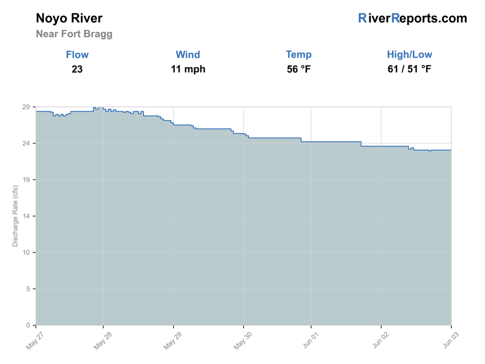
USGS data chart
Official USGS trend
Streamflow over the latest USGS reporting window.
Latest
23 cfs
Jun 3, 4 PM UTC
Weather
River weather report
Weather can change wading safety, road access, water temperature, hatches, and the best time of day to fish.
Live forecast loads as you reach this section
This keeps the report fast while still using the official National Weather Service forecast point.
Hatches and flies
Hatch chart and fly picks
Winter
Sparse midges, winter stones, salmonid eggs where legal, and baitfish movement
Small black stone, egg pattern where legal, soft hackle, black leech, small baitfish
Spring
BWOs, caddis, small mayflies, sculpins, and fry movement
BWO emerger, caddis pupa, soft hackle, sculpin, small clouser
Summer
Terrestrials, caddis, midges, warmwater forage, and estuary bait
Foam ant, small caddis, popper, baitfish streamer, crayfish
Fall
First rain pulses, small olives, caddis, and salmonid migration cues
Soft hackle, BWO, small streamer, muddler, sparse steelhead wet fly
Steelhead and salmonid flies
Sparse wet fly, black leech, egg pattern where legal, muddler, small intruder, soft hackle
Use only when the river is open, flows are legal, and the reach supports a salmonid plan.
Search streamers
Sculpin, clouser, olive bugger, black bugger, small baitfish
Use on clearing flows, deeper bends, shaded cutbanks, and estuary-influenced water.
Light-water flies
BWO emerger, caddis pupa, soft hackle, small nymph, foam ant
Use in smaller legal water, soft edges, or when clear low flows demand a subtle presentation.
Tactics
How to fish it
Check open status before leaving home, then match the gauge to clarity when you arrive.
Swing sparse flies or small streamers through soft traveling lanes only when the river is legal and fishable.
Avoid redds, staging fish, and crowded slots; these rivers depend on careful handling.
Keep a backup plan because coastal rivers can close or blow out quickly.
Rigging
Rod, leader, and setup notes
A 7- or 8-weight is appropriate for legal winter steelhead work; lighter rods fit trout or smaller water only where legal.
Carry floating and light sink-tip options, sparse wet flies, leeches, and small baitfish patterns.
Use barbless hooks and quick releases for wild salmonids.
Bring rain gear, a wading staff, and a backup plan for closures or dirty water.
Access
Access and planning notes
Noyo Mooring Basin / lower river
Lower-river contextWade / float / trail
Harbor / bank / boat traffic
When to pick it
Use this when lower-river access, coastal weather, and rules are suitable.
Caution
Harbor access is not a complete fishing-access map.
Fort Bragg access orbit
Trip baseWade / float / trail
Road / services / lower scout
When to pick it
Start here when wind, tide, parking, and legal status can be checked before fishing.
Caution
Private banks and harbor rules need current confirmation.
Upstream Noyo scouting
Steelhead reach checkWade / float / trail
Road / bank scout
When to pick it
Pick it only when access is clearly public and flow is clearing.
Caution
Do not assume a bank is public just because it is near the river.
California State Parks boating facility records identify Noyo River public facilities, but anglers should separate harbor access from upstream fishing access and land status.
Confirm parking, land ownership, and current agency notices before relying on any access point.
Harbor traffic, tide influence, cold water, slick banks, private land, and storm runoff
Regulations
Check before fishing
Check CDFW low-flow rules, current sport fishing regulations, and steelhead report-card requirements before fishing. Open status can change during the season.
Primary base
Fort Bragg
Best day style
Lower river, harbor/boating access, low-flow-rule checks, and private-land caution
Check first
CDFW low-flow status, USGS Noyo flow, harbor access, coastal weather, and tide/wind
Safety
Harbor traffic, tide influence, cold water, slick banks, private land, and storm runoff
Gear
Helpful gear for this water
7- or 8-weight rod
Appropriate for legal winter steelhead water and bigger coastal flows.
Sink-tip option
Useful for deeper traveling lanes and post-storm color.
Steelhead card
Required when fishing for steelhead in California anadromous waters.
Rain and safety kit
Coastal storms, cold water, and remote bars require conservative packing.
Nearby water
Other water to research
Backup logic
High water
Wait for clearing or compare the Navarro, Mattole, or Eel after checking their low-flow status.
Heat
Avoid salmonid pressure in warm low water and choose another target.
Coastal storms or wind
Skip lower-river and harbor-adjacent plans until weather and visibility improve.
Access issue
Use confirmed public access or choose another North Coast river rather than guessing at private banks.
Navarro River
A nearby Mendocino low-flow-rule river with redwood access.
Mattole River
A more remote Lost Coast salmonid system.
Eel River
A larger North Coast gauge and steelhead planning page.
FAQ
Fast answers
Is Noyo River fishable today?
Noyo River looks very fishable right now. The live score is 91/100, based on current flow, weather, public alerts, and the report's planning context. Recheck the linked gauge and forecast before leaving because conditions can change quickly after rain, heat, access changes, or flow swings.
What flow is best for Noyo River?
Open under CDFW low-flow rules, dropping after rain, and clear enough to fish without stressing salmonids.
When should I skip Noyo River?
Skip during closures, muddy storm spikes, hot low water, or when access depends on private-land assumptions.
Is Noyo River safe to wade right now?
The fishability score is not a wading guarantee. Wade only where your chosen access has safe edges, clear footing, legal entry, and no forced crossings; high, rising, stained, or storm-affected water should be treated conservatively.
Is Noyo River usually open for fly fishing?
Do not assume it is open. North Coast low-flow rules and salmonid protections can close these waters when flows are too low or conditions are stressful.
Should I wade or float?
Wading from legal access is usually the safer planning baseline. Floating requires current local access knowledge, safe flow, and a realistic takeout.
Which flow source should I use?
Use the RiverReports chart for a fast read and USGS 11468500 as the official flow source or context source.
Sources
Source set for this report
Reviewed 2026-05-31