
California / West
Lower Klamath River
A lower-river Klamath report for flow checks near the mouth, salmon and steelhead regulation planning, tribal and private-land caution, and practical fly choices.
Image: Generated regional planning image for Lower Klamath River / BlueStreamFly generated; not exact location / BlueStreamFlyFishability now: Lower Klamath River fishability today
GreatData confidence: High96/100
Fishable now because the live gauge is stable, weather is mild, and no public alert is active.
Flow observed
3:30 PM UTC
Weather observed
4:00 PM UTC
Score calculated
4:20 PM UTC
Why this rating
Flow
Water temperature
Public alerts
Next 6-12 hours
Hold
Stable live data supports staying with the plan, but recheck the gauge and forecast before leaving.
USGS flow
5,370 cfs
Current trend: flow stable, so weather, temperature, and access checks drive the next change.
More planning details: flies, flow bands, and live source checks
Fish it today
Start here
Build the day around one lower-river objective such as a legal travel-lane swing or a short bank session near a confirmed public corridor. Do not waste time assuming every visible bend near Klamath or Weitchpec is fishable public water.
Best flow clue
Use the near-mouth gauge as a trend tool, not as a simple green light. Stable medium flows and cooler conditions are the best fit for lower-river salmonid plans, while storm-driven rises, dirty water, or hot low-flow periods usually mean you should wait it out or move elsewhere.
Skip trigger
Skip the lower Klamath when quota or emergency status is unclear, when coastal storms push the river high and dirty, when lower-river temperatures make release quality questionable, or when your entire plan depends on walking across land that is not clearly open to public fishing access.
Flow decision bands
Open and fishable
Legal open status, cool enough water, safe lower-river access, and a clearing flow trend must all line up.
Best lower-river window
Falling post-storm flow with fishable visibility, mild coastal weather, and confirmed public access creates the best green light.
Too dirty or risky
Coastal storm pulses, soft banks, surf-zone weather, or rising water should pause the lower-river plan.
Quota or access hard stop
CDFW quota/emergency updates plus tribal, private, and estuary boundaries can override good conditions.
USGS flow
5,370 cfs
Current trend: flow stable, so weather, temperature, and access checks drive the next change.
Live USGS flow
5,390 cfs / stable
Live NWS forecast
54F / Mostly Cloudy
Live water temperature
66F from USGS
No NWS alert flag
No active NWS alert was returned for this forecast point.
Use the near-mouth Klamath gauge to judge lower-river flow and tide-influenced planning.
Confirm whether the exact reach, species, season, and quota are open before fishing.
Do not assume bank access across tribal or private land without permission.
Carry steelhead report-card information and handle wild fish quickly in cold, clean water.
Editorial review
How this report is maintained
This lower Klamath report is maintained from current rule, flow, weather, and habitat sources so anglers can plan the near-coast corridor with realistic access and quota context instead of old assumptions about open bank water.
Byline
BlueStreamFly editorial team
Reviewed by
BlueStreamFly source review
Maintained by
Mountain Brook Run LLC
Last material review
2026-05-31
Report confidence
Good confidence
85/100
Good confidence: RiverReports, USGS lower Klamath flow, CDFW rule sources, NOAA habitat context, and weather data support the page. Confidence is moderated by quota and emergency changes, coastal storm volatility, tribal/private access, estuary complexity, and salmonid temperature stress.
Regulations
CDFW Klamath-Trinity, salmon, and reopening sources support the legal-check path.
Access
NOAA and local lower-river context support planning, but exact public access, tribal/private boundaries, and estuary areas need current confirmation.
Flow and weather
RiverReports, USGS 11530500, and the National Weather Service point are attached to the route.
Fishing usefulness
The page now separates lower-river flow, coastal storm timing, quota checks, access boundaries, and backup species/water choices.
Fishability dashboard and source review
2026-05-31 / material content or source review
RiverReports, USGS Klamath near Klamath flow, CDFW Klamath-Trinity and salmon regulation sources, CDFW reopening material, NOAA Klamath habitat context, and the National Weather Service point were checked before updating the current-fishability decision layer.
2026-05-31
Updated Lower Klamath River to the current fishability-page standard with lower-river rule checks, tide/coastal access cautions, backup cues, stable fishability SEO, and confidence signals.
2026-05-28
Added lower-basin trip-fit guidance, wade-versus-boat caution, tribal and private access nuance, storm and temperature skip cues, pressure timing, backup-water suggestions, stronger editorial review signals, and a page-specific report-confidence meter after source review.
2026-05-24
Initial source-reviewed report published with flows, weather, hatches, flies, tactics, access, regulations, and FAQs.
Angler planning edge
Local details that change the plan
Best for
Salmon and steelhead anglers who understand that legal status and access matter more here than matching a hatch chart, Lower-basin trips timed around cool weather, stable flows, and a confirmed open season, Experienced anglers who can separate estuary, lower valley, and upper-basin planning instead of treating the whole Klamath like one river, Travelers who want a clear correction path before committing to a remote coastal day
Wade or float
Treat the lower Klamath as a cautious mixed-access page. Some days are best handled as short, legal bank sessions or controlled drift coverage rather than ambitious all-day wading, because the lower river is broad, boundary-sensitive, and more affected by weather and lower-basin conditions than many interior steelhead rivers.
Best flows
Use the near-mouth gauge as a trend tool, not as a simple green light. Stable medium flows and cooler conditions are the best fit for lower-river salmonid plans, while storm-driven rises, dirty water, or hot low-flow periods usually mean you should wait it out or move elsewhere.
When to skip
Skip the lower Klamath when quota or emergency status is unclear, when coastal storms push the river high and dirty, when lower-river temperatures make release quality questionable, or when your entire plan depends on walking across land that is not clearly open to public fishing access.
Local plan
Build the day around one lower-river objective such as a legal travel-lane swing or a short bank session near a confirmed public corridor. Do not waste time assuming every visible bend near Klamath or Weitchpec is fishable public water.
Pressure
Pressure is often tied to salmon and steelhead timing rather than steady daily trout traffic. When lower-basin seasons are attractive, the handful of obvious public approaches can gather anglers quickly, so early starts and realistic backup options matter.
Access nuance
The lower Klamath is defined by tribal, private, estuary, and public boundaries. Habitat importance and fish movement make the river look inviting on a map, but legal entry points are narrower than the visible water suggests and should be confirmed before the trip.
Backup water
If the lower Klamath is blown out, unclear, or too crowded, pivot to the Trinity for a more structured access and steelhead-planning day or to the upper Klamath page if the interior basin is the better fit.
About the river
Setting, character, and why it fishes the way it does.
The Klamath River drains a large northern California and southern Oregon basin before reaching the Pacific near the community of Klamath.
The lower river is culturally and ecologically important, with tribal fisheries, salmon recovery work, steelhead migration, lamprey, and estuary habitat all shaping how anglers should approach it.
Recent Klamath dam removal and fishery-recovery work make this a river where old assumptions can be wrong. Current agency sources matter more than older fishing reports.
This page is scoped to the lower river near the coast and lower valley, not the upper Klamath tailwater below Iron Gate Dam.
Target species
Steelhead
A key fly target when current CDFW rules, report-card requirements, flows, and access allow fishing.
Chinook salmon
Highly regulation-dependent in 2026. Check CDFW Klamath-Trinity and salmon pages before planning any salmon trip.
Coho salmon
Protected fish should not be targeted or retained. Learn identification before fishing the basin.
Resident trout and native fish
Use careful handling and conservative tactics around juvenile salmonids and sensitive habitat.
Reading the water
Low and clear
Lengthen leaders, use smaller wet flies or sparse intruders, and focus on low-light travel lanes.
Stable medium flow
Swing runs, tailouts, and broad walking-speed seams where access is legal and wading is safe.
High or rising
Expect difficult wading and poor visibility. Fish edges only if safe, or wait for a falling trend.
Warm or stressful water
Back off salmonids when temperature or handling conditions are poor, especially during low-flow periods.
Best seasons
Late summer
Useful only if the current CDFW season and quota allow fishing and water conditions are safe.
Fall
Classic salmon and steelhead timing, but rule changes and quota status must drive the plan.
Winter
Steelhead timing can improve after rain, with high-water safety and access limits in play.
Spring
Check current rules and avoid making assumptions from older Klamath reports.
Preferred flow source
Klamath River near Klamath
RiverReports is the preferred chart source when coverage exists. When a matching USGS gauge exists, keep it open as the official backstop for station data and current hydrograph context.
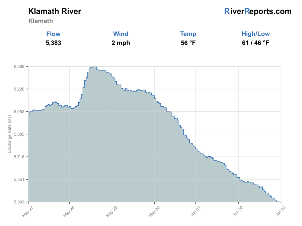
USGS data chart
Official USGS trend
Streamflow over the latest USGS reporting window.
Latest
5,370 cfs
Jun 3, 4 PM UTC
Weather
River weather report
Weather can change wading safety, road access, water temperature, hatches, and the best time of day to fish.
Live forecast loads as you reach this section
This keeps the report fast while still using the official National Weather Service forecast point.
Hatches and flies
Hatch chart and fly picks
Late summer
Caddis, small mayflies, baitfish and estuary influence
Soft hackle, muddler, small intruder, low-water wet fly
Fall
Sparse aquatic insects, salmon and steelhead movement
Comet, green-butt skunk, intruder, egg-sucking leech
Winter
Midges, BWOs, high-water edge food
Winter steelhead fly, leech, egg pattern where legal, nymph
Spring
BWOs, caddis, small stoneflies
Soft hackle, caddis pupa, small nymph, sparse streamer
Swing flies
Green-butt skunk, muddler, comet, silver hilton, small intruder
Use when steelhead or salmonids are moving and the run has safe walking-speed swing water.
Low-water flies
Small wet fly, soft hackle, sparse hairwing, skater
Use in clear low flows, especially early and late in the day.
High-water flies
Leech, intruder, bright comet, large wet fly
Use only from safe edges when the river is up but still fishable.
Trout and juvenile-friendly choices
Caddis pupa, BWO nymph, soft hackle, small streamer
Use with careful handling when legal trout or steelhead fishing is the goal.
Tactics
How to fish it
Start by reading the current CDFW Klamath-Trinity and emergency-closure sources.
Pick a reach only after confirming public access or permission.
For steelhead, step through runs slowly and change fly depth before changing locations.
Avoid fishing over visible spawning fish or redds.
Use barbless hooks and a net so wild fish can be released quickly.
Have a backup plan because quotas, closures, high water, and access limits can change the day.
Rigging
Rod, leader, and setup notes
A 7-weight or 8-weight two-hand rod is useful for winter and fall swing water.
A 9-foot 6-weight or 7-weight can work for smaller flies, lower flows, and nymphing where legal.
Carry floating, intermediate, and sink-tip options instead of forcing one presentation.
Use strong leaders for large fish, but downsize in low clear water.
Bring a thermometer, rain shell, wading staff, and reliable offline maps.
Access
Access and planning notes
Klamath near-mouth gauge corridor
Lower flow contextWade / float / trail
Bank / lower-river scout
When to pick it
Start here when flow, legal status, and access permission are clear.
Caution
Near-mouth flow does not grant bank access across tribal or private land.
Weitchpec and lower valley
Reach and access comparisonWade / float / trail
Road / bank / large-river scout
When to pick it
Use it when lower weather, clarity, and rule status need a second reach check.
Caution
Boundary and permission checks matter as much as the gauge.
Estuary and mouth area
Coastal weather checkWade / float / trail
Lower river / tide-adjacent
When to pick it
Pick this context only when surf, wind, tide-adjacent water, and rules are suitable.
Caution
Estuary-area rules and safety differ from upstream steelhead water.
Do not cross tribal or private land unless you have clear permission.
CDFW pages and in-season updates are more important than older local reports.
Lower-river weather can be wet, cold, and foggy even when inland areas are warm.
Flows, water temperature, and turbidity can change quickly after coastal storms.
If the 2026 regulation status is unclear, treat the page as planning guidance and verify with CDFW before fishing.
Regulations
Check before fishing
Check CDFW's current Klamath-Trinity regulations, salmon quota updates, emergency closures, and report-card rules before fishing. The 2026 reopening process makes current agency guidance essential.
Primary base
Klamath, Weitchpec, or coastal Humboldt and Del Norte County towns
Best day style
Limited public access with tribal, private, and estuary boundaries
Check first
CDFW Klamath-Trinity updates, quota status, access boundaries, flow, weather
Safety
Cold coastal weather, changing flows, remote access, tribal/private boundaries
Gear
Helpful gear for this water
Two-hand or switch rod
Helpful for covering broad lower-river swing water when flows and access allow.
Wading staff and studs
Lower-river rocks, changing depth, and current make conservative wading important.
Report-card setup
Required for applicable anadromous fishing under California rules.
Rain and cold-weather layers
Coastal weather can shift fast, especially in fall and winter.
Nearby water
Other water to research
Backup logic
High water
Wait for a falling and clearing trend or compare the Trinity or upper Klamath.
Heat
Avoid salmonid stress and move to colder trout water such as the McCloud or Hat Creek.
Storms or stain
Let the coastal pulse pass and recheck visibility before fishing lower bars.
Access issue
Use a signed public plan or leave the lower river rather than guessing at tribal/private boundaries.
Klamath River
Use this separate report for the upper Klamath below Iron Gate and dam-removal recovery context.
Trinity River
A major Klamath tributary with Lewiston tailwater flows, steelhead culture, and section-specific rules.
McCloud River
A different northern California trout plan with canyon access and strict access boundaries.
FAQ
Fast answers
Is Lower Klamath River fishable today?
Lower Klamath River looks very fishable right now. The live score is 96/100, based on current flow, weather, public alerts, and the report's planning context. Recheck the linked gauge and forecast before leaving because conditions can change quickly after rain, heat, access changes, or flow swings.
What flow is best for Lower Klamath River?
Use the near-mouth gauge as a trend tool, not as a simple green light. Stable medium flows and cooler conditions are the best fit for lower-river salmonid plans, while storm-driven rises, dirty water, or hot low-flow periods usually mean you should wait it out or move elsewhere.
When should I skip Lower Klamath River?
Skip the lower Klamath when quota or emergency status is unclear, when coastal storms push the river high and dirty, when lower-river temperatures make release quality questionable, or when your entire plan depends on walking across land that is not clearly open to public fishing access.
Is Lower Klamath River safe to wade right now?
The fishability score is not a wading guarantee. Wade only where your chosen access has safe edges, clear footing, legal entry, and no forced crossings; high, rising, stained, or storm-affected water should be treated conservatively.
Is the Lower Klamath open for salmon in 2026?
CDFW announced 2026 Klamath-Trinity reopening details, but anglers still need to verify final season, quota, reach, and emergency-closure status before fishing.
What flow gauge should I check?
Use the Klamath River near Klamath gauge, USGS 11530500, for lower-river flow context near the coast.
Can I walk the banks anywhere?
No. The lower river includes tribal, private, and public lands. Confirm access before leaving a road, launch, or developed site.
What is the safest fly-fishing approach?
Verify rules first, fish legal public water, swing or drift flies through safe travel lanes, and handle wild salmonids quickly.
Sources
Source set for this report
Reviewed 2026-05-31