
Wisconsin / Midwest
Sheboygan River
A Sheboygan River report built around DNR shoreline access, steelhead-season public parks, and the lower-river cleanup and fish-consumption cautions anglers still need to respect.
Image: Generated Sheboygan River planning image / BlueStreamFly generated; not exact location / BlueStreamFlyFishability now: Sheboygan River fishability today
GreatData confidence: High96/100
Fishable now because SHEBOYGAN gauge is stable, weather is usable, and no public alert is active.
Flow observed
5:00 PM UTC
Weather observed
5:00 PM UTC
Score calculated
5:24 PM UTC
Why this rating
Flow
Weather
Public alerts
Next 6-12 hours
Hold
Stable live data supports staying with the plan, but recheck the gauge and forecast before leaving.
USGS flow
205 cfs
Current trend: flow stable, so weather, temperature, and access checks drive the next change.
More planning details: flies, flow bands, and live source checks
Fish it today
Start here
Pick one public park access, fish it hard, and move only if another named site gives you a real current or crowding advantage.
Best flow clue
Best when the lower river is cool, steady, and clear enough to read holding lanes without turning every step into a footing fight.
Skip trigger
Skip dirty surges, ice-slick banks, and any day when contamination and harvest questions dominate the value of the trip.
Flow decision bands
Stable cool lower-river flow
This is the best steelhead and brown-trout signal when park access, visibility, and safe footing all line up.
Post-rain color with shape
Sometimes useful after the river settles, but unsafe banks or opaque water should end the plan.
Summer low flow
A weak primary fly-fishing window unless you have a specific lower-river warmwater plan.
Dirty surge, ice, or advisory-dominated day
A clear skip signal when the trip becomes more about risk than fishing.
USGS flow
205 cfs
Current trend: flow stable, so weather, temperature, and access checks drive the next change.
Live USGS flow
205 cfs / stable
Live NWS forecast
73F / Mostly Sunny
Water temperature not verified
Heat guidance uses weather and river type unless an official water-temperature value is available.
No NWS alert flag
No active NWS alert was returned for this forecast point.
Wisconsin's close-to-home guide lists Kiwanis Park, Roy Sebald Sheboygan River Natural Area, and Esslingen Park as public Sheboygan River access points with steelhead and brown-trout value.
The tributary access PDF adds the Eighth Street Boat Ramp and confirms the lower public access corridor below Kohler Dam.
Wisconsin DNR's Sheboygan Area of Concern page says the lower 14 miles of the river and harbor have fish-consumption advisories tied to PCB contamination.
Use RiverReports for trend and USGS 04086000 as the official lower-river flow check before you commit to one of the park accesses.
Editorial review
How this report is maintained
This report starts with official regulation, access, flow, weather, and public-water sources, then adds practical planning guidance for fly anglers.
Byline
BlueStreamFly editorial desk
Reviewed by
BlueStreamFly source review
Maintained by
BlueStreamFly
Last material review
2026-06-03
Report confidence
Good confidence
88/100
Good confidence: RiverReports, USGS 04086000 at Sheboygan, Wisconsin regulation and tributary access sources, Sheboygan public-access mapping, close-to-home park guidance, Area of Concern and advisory sources, weather data, and route-specific urban tributary guidance support the page. Confidence is moderated by urban-bank safety, run timing, advisory decisions, crowding, ice, and muddy surges.
Regulations
Wisconsin fishing regulations and Great Lakes tributary sources support current legal and seasonal checks.
Access
Wisconsin DNR tributary maps, public park guidance, and voluntary-access context support public planning, while exact bank conditions and crowding remain current checks.
Flow and weather
RiverReports, USGS 04086000 at Sheboygan, and the National Weather Service point support live flow and weather decisions.
Fishing usefulness
The page now separates Sheboygan flow, public-park starts, run timing, Area of Concern and harvest cautions, dirty-water skips, and nearby tributary backups.
Fishability dashboard and source review
2026-06-03 / material content or source review
RiverReports, USGS 04086000 at Sheboygan, Wisconsin regulations, DNR Lake Michigan tributary access sources, Sheboygan access mapping, close-to-home public park guidance, Sheboygan River Area of Concern and consumption-advisory sources, National Weather Service point data, and route-specific urban tributary guidance were checked before updating the current-fishability decision layer.
2026-06-03
Updated Sheboygan River to the current fishability-page standard with Sheboygan flow bands, public-park access cards, advisory and run-season backup cues, stable fishability SEO, and confidence signals.
2026-05-27
Published a new Sheboygan River page with mapped public access, RiverReports plus USGS flow support, and lower-river contamination and harvest cautions translated into angler-facing guidance.
Angler planning edge
Local details that change the plan
Best for
Public-park steelhead checks, Short urban tributary sessions, Anglers who want clear official access and honest harvest cautions
Wade or float
Mostly shoreline and short-wade fishing from public parks and launches rather than a float page.
Best flows
Best when the lower river is cool, steady, and clear enough to read holding lanes without turning every step into a footing fight.
When to skip
Skip dirty surges, ice-slick banks, and any day when contamination and harvest questions dominate the value of the trip.
Local plan
Pick one public park access, fish it hard, and move only if another named site gives you a real current or crowding advantage.
Pressure
Pressure is concentrated but manageable because the lower river offers several named public starts within a short drive.
Access nuance
The easy public access is a strength, but it also means you should expect company during the best steelhead windows and adjust your positioning accordingly.
Backup water
Move to Manitowoc or Kewaunee when the Sheboygan lower corridor is too crowded, too dirty, or too advisory-heavy for the kind of day you want.
About the river
Setting, character, and why it fishes the way it does.
The Sheboygan River is an urban-access Lake Michigan tributary, which makes it easier to fish than many of its neighbors and easier to oversimplify. The park access is real, but so are the lower-river contamination and harvest cautions that remain part of the official source picture.
This page therefore focuses on the lower public corridor, where the access is documented and the run-fish timing makes the most sense. It is not a promise that the whole watershed fishes like the city access parks.
The official cleanup story also matters because it changes how you talk about keeping fish. A page that ignores that would be less helpful, not more.
Target species
Steelhead
The main shoulder-season draw along the lower public park corridor.
Brown trout
A realistic cold-season and fall-migration target in the same lower public sections.
White sucker and mixed lower-river fish
Part of the DNR-listed lower-river species reality and useful as a reminder that this is not a pure trout stream.
Reading the water
Stable cool run-season flow
Best for covering the lower urban-access corridor with eggs, leeches, and short swings.
Post-rain color with shape
Sometimes productive if visibility and footing remain manageable from the park accesses.
Summer low flow
Not the main reason to fish Sheboygan on fly gear unless you have a very specific lower-river backup plan.
Dirty surge or unsafe bank conditions
A clear skip signal even if the easy public access makes the river tempting.
Best seasons
Spring
Prime steelhead timing with the strongest case for the lower public accesses.
Fall
A good window for brown-trout and salmon-related tributary movement.
Winter
Possible only on safe open-water days with conservative footing decisions.
Summer
A secondary period that should not be oversold compared with the stronger migratory windows.
Preferred flow source
SHEBOYGAN RIVER AT SHEBOYGAN, WI
RiverReports is the preferred chart source when coverage exists. When a matching USGS gauge exists, keep it open as the official backstop for station data and current hydrograph context.
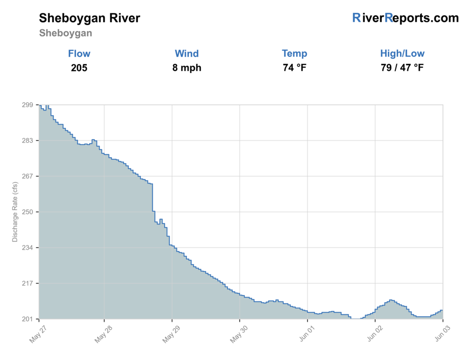
USGS data chart
Official USGS trend
Streamflow over the latest USGS reporting window.
Latest
205 cfs
Jun 3, 5 PM UTC
Weather
River weather report
Weather can change wading safety, road access, water temperature, hatches, and the best time of day to fish.
Live forecast loads as you reach this section
This keeps the report fast while still using the official National Weather Service forecast point.
Hatches and flies
Hatch chart and fly picks
March to April
Steelhead eggs, cold-water baitfish, and high, dark tributary windows
Egg pattern, yarn fly, small nymph, leech, sparse baitfish streamer
September to November
Salmon migration, brown-trout push, and baitfish-driven lower-river feeding
Egg pattern, woolly bugger, intruder-style swing fly, baitfish streamer
Summer
Warmwater insect windows, baitfish, and smallmouth opportunism in lower reaches
Poppers, Clouser, crayfish, foam beetle
Winter
Slow deep-hold trout fishing where open water remains
Egg pattern, midge, small leech, stonefly nymph
Run-season flies
Egg patterns, woolly bugger, leech, sparse swing streamer
The core choices whenever steelhead, brown trout, or salmon are the reason you are on the river.
Warmwater backup box
Clouser, crayfish, popper, woolly bugger
Useful in lower public reaches when migratory fish are absent and smallmouth or pike take over the plan.
Nymphs
Stonefly, pheasant tail, zebra midge, soft hackle
Helpful on clearer stable flows when trout are not moving far to chase larger profiles.
Tactics
How to fish it
Start at one of the named public parks and fish it thoroughly instead of bouncing between urban pull-ins and losing the best light.
During the steelhead windows, lead with eggs, leeches, and compact swing flies around current breaks and softer holding lanes.
Keep your lower-river plan mobile but short. The public access makes it easy to move, but the river still rewards reading one piece well.
If the water looks unsafe or the lower river smells like a harvest question more than a fishing day, leave fish in the river and shorten the trip.
Rigging
Rod, leader, and setup notes
A 6- or 7-weight is still the right all-around choice for Sheboygan's run-season fish and open banks.
A floating line with split shot or short sink-tip options covers most lower-river park access water.
Carry a net and dry gloves because cold hands and slippery urban rocks create avoidable release mistakes.
Keep a compact kit because the public parks make it easy to reposition without carrying a giant pack.
Access
Access and planning notes
Kiwanis Park
Primary lower-river public startWade / float / trail
Urban park / bank / short wade
When to pick it
Start here when flow, season, and crowding support a short clean session.
Caution
Easy access does not fix slippery banks, high color, or harvest cautions.
Roy Sebald Natural Area and Esslingen Park
Lower public alternativesWade / float / trail
Park / shoreline / short wade
When to pick it
Use them when you need another mapped public start below the main city corridor.
Caution
Move because conditions improve, not just because parking is available.
Eighth Street Boat Ramp
Lower river condition checkWade / float / trail
Ramp / shoreline / scout
When to pick it
Pick it when wind, lake influence, or crowding makes a lower-river read useful.
Caution
Urban lower-river access should stay conservative around cold water and advisory context.
This page stays in the lower public corridor because that is where the official access mapping is strongest.
The DNR voluntary public access materials also show upper-basin public access to Sheboygan River farther inland, but this report is centered on the lower urban tributary identity.
The lower river's cleanup history means access convenience should never be confused with carefree harvest advice.
Regulations
Check before fishing
Check current Wisconsin fishing regulations and tributary-season rules before fishing the Sheboygan River. The lower river and harbor also carry fish-consumption advisories, so review Wisconsin's advisory guidance before keeping any fish.
Primary base
Sheboygan, Indiana Avenue access points, and the lower river below Kohler Dam
Best day style
Urban park access, short shoreline sessions, and careful lower-river wading
Check first
Wisconsin regulations, the 04086000 trend, public park access, and whether the lower river is giving you a run-fish window or a cleanup-affected caution day
Safety
Cold water, slippery urban banks, changing lower-river flows, and fish-consumption limits tied to the lower 14 miles of the river
Gear
Helpful gear for this water
6- or 7-weight rod
The better all-around fit for tributary steelhead, lake-run browns, and windy lower-river conditions.
Wading staff and layered rain shell
Great Lakes tributaries are usually a cold-water and slick-bank problem before they are a fly-selection problem.
Thermometer and polarized glasses
Useful for deciding when lower-river warmwater water is too warm, too dirty, or simply not worth forcing.
Dry bag and spare gloves
Particularly valuable during spring steelhead and fall salmon weather swings.
Nearby water
Other water to research
Backup logic
Unsafe high color
Compare Manitowoc or Kewaunee only after checking their gauges and public-access status.
Run-season crowding
Move among named public parks or wait for a lower-pressure window.
Harvest or advisory concern
Leave fish in the river and review Wisconsin consumption guidance before keeping anything.
Summer low-value window
Use Sheboygan Marsh or another warmwater plan instead of forcing the lower tributary.
Manitowoc River
A nearby tributary alternative when you want a less urban shoreline feel with still-strong public access.
Kewaunee River
A good switch when you want a warmer-river fallback and a clearer hatchery-centered migration story.
Sheboygan Marsh
A different local plan if tributary conditions are poor and you want a calmer warmwater public option.
FAQ
Fast answers
Is Sheboygan River fishable today?
Sheboygan River looks very fishable right now. The live score is 96/100, based on current flow, weather, public alerts, and the report's planning context. Recheck the linked gauge and forecast before leaving because conditions can change quickly after rain, heat, access changes, or flow swings.
What flow is best for Sheboygan River?
Best when the lower river is cool, steady, and clear enough to read holding lanes without turning every step into a footing fight.
When should I skip Sheboygan River?
Skip dirty surges, ice-slick banks, and any day when contamination and harvest questions dominate the value of the trip.
Is Sheboygan River safe to wade right now?
The fishability score is not a wading guarantee. Wade only where your chosen access has safe edges, clear footing, legal entry, and no forced crossings; high, rising, stained, or storm-affected water should be treated conservatively.
What is the best starting access on the Sheboygan River?
Kiwanis Park, Roy Sebald Natural Area, and Esslingen Park are the cleanest official starts because Wisconsin DNR lists all three as lower-river public access points.
Should I keep fish from the lower Sheboygan River?
Be very careful. Wisconsin DNR says the lower 14 miles of the river and harbor carry fish-consumption advisories tied to contamination, so review the current advisory before keeping anything.
Is this a steelhead-only page?
The best windows are steelhead and shoulder-season trout windows, but the river also supports other lower-river fish and should not be treated like a pure trout stream.
When should I skip the Sheboygan River?
Skip unsafe high color, icy banks, or any day when public access is easy but the actual fishing window is not worth the cold-water and advisory tradeoffs.
Sources
Source set for this report
Reviewed 2026-06-03