
Virginia / Southeast
Upper James River
An Upper James report for Iron Gate, Buchanan, Eagle Rock, Glasgow, and Balcony Falls smallmouth and muskie float planning.
Image: Generated regional planning image for Upper James River / BlueStreamFly generated; not exact location / BlueStreamFlyFishability now: Upper James River fishability today
GreatData confidence: High96/100
Fishable now because Eagle Rock gauge is falling, weather is mild, and no public alert is active.
Flow observed
3:00 PM UTC
Weather observed
3:00 PM UTC
Score calculated
3:22 PM UTC
Why this rating
Flow
Weather
Public alerts
Next 6-12 hours
Improving / hold
A falling gauge and usable weather should keep the next 6-12 hours in play unless tributaries stain or heat builds.
USGS flow
1,160 cfs
Current trend: flow falling, rating likely holding strong unless weather or clarity changes.
More planning details: flies, flow bands, and live source checks
Fish it today
Start here
Start with DWR access and the Buchanan/Eagle Rock flow, then pick one realistic Iron Gate, Buchanan, Eagle Rock, Glasgow, or Balcony Falls-area float with confirmed put-in, takeout, and weather backup.
Best flow clue
Use RiverReports and USGS 02019500 at Buchanan/Eagle Rock as the main live trend, with USGS 02025500 at Holcomb Rock as downstream context. Stable moderate flows are best; very low water drags floats, while rising or stained water raises hazard risk.
Skip trigger
Skip or shorten the plan when thunderstorms are upstream, whitewater sections are above your skill, the shuttle is not confirmed, heat is excessive, water is muddy, or fish-consumption guidance has not been checked for harvest plans.
Flow decision bands
Stable upper-river float flow
Stable moderate Buchanan/Eagle Rock flow with Holcomb Rock context is the cleanest smallmouth and muskie planning signal.
Best float window
Confirmed DWR access, manageable ledges, safe whitewater skill match, and a realistic shuttle make the day strongest.
Low, high, or stormy
Very low water can drag floats; rising, muddy, or storm-influenced water should shorten or cancel the plan.
Whitewater and heat check
Balcony Falls, dams, excessive heat, and long shuttle gaps should be decided before flies are tied on.
USGS flow
1,160 cfs
Current trend: flow falling, rating likely holding strong unless weather or clarity changes.
Live USGS flow
1,180 cfs / falling about 40%
Live NWS forecast
69F / Sunny
Water temperature not verified
Heat guidance uses weather and river type unless an official water-temperature value is available.
No NWS alert flag
No active NWS alert was returned for this forecast point.
Use the Eagle Rock/Buchanan flow context before choosing a float.
Fish smallmouth around ledges, riffle tails, wooded banks, and island seams.
Carry poppers, baitfish streamers, crayfish, and hellgrammites.
Plan around Balcony Falls/Snowden hazards, dams, and long shuttles.
Editorial review
How this report is maintained
This report is maintained from current regulation, access, flow, weather, and public planning sources so anglers can make better trip decisions than a raw gauge or generic overview would allow.
Byline
BlueStreamFly editorial team
Reviewed by
BlueStreamFly source review
Maintained by
Mountain Brook Run LLC
Last material review
2026-06-01
Report confidence
High confidence
90/100
High confidence: Virginia DWR regulation, access, forecast, and waterbody sources, fish-consumption guidance, RiverReports plus USGS Buchanan and Holcomb Rock flow, weather coverage, and route-specific float guidance support the page. Confidence is moderated by whitewater hazards, long-float logistics, dams, heat, and generated regional imagery.
Regulations
Virginia DWR freshwater rules, non-tidal forecast, and fish-consumption sources support legal and harvest checks.
Access
DWR Upper and Middle James and access-list sources support float and ramp planning.
Flow and weather
RiverReports coverage is backed by USGS 02019500, with USGS 02025500 as downstream context, and the National Weather Service point supports live weather decisions.
Fishing usefulness
The page now separates upper-river smallmouth tactics, muskie context, shuttle length, whitewater safety, heat, flow context, and backup-water choices.
Fishability dashboard and source review
2026-06-01 / material content or source review
Virginia DWR freshwater regulation, non-tidal forecast, Upper and Middle James waterbody and access-list sources, fish-consumption advisory context, RiverReports, USGS Buchanan and Holcomb Rock flow data, National Weather Service data, and generated-image disclosure were checked before updating the current-fishability decision layer.
2026-06-01
Updated Upper James River to the current fishability-page standard with Buchanan and Holcomb Rock flow bands, upper-river float cards, backup cues, stable fishability SEO, and confidence signals.
2026-05-29
Added Upper James River trip-fit guidance, Eagle Rock and Buchanan flow framing, water-trail and whitewater safety, shuttle planning, smallmouth and muskie context, backup-water suggestions, editorial review signals, and a page-specific confidence meter after source review.
2026-05-24
Initial source-reviewed report published with flows, weather, hatches, flies, tactics, access, regulations, and FAQs.
Angler planning edge
Local details that change the plan
Best for
Virginia warmwater fly anglers planning upper James floats around Iron Gate, Buchanan, Eagle Rock, Glasgow, and Balcony Falls, Smallmouth, rock bass, muskie, topwater, crayfish, hellgrammite, and streamer days where float length and flow are the first decisions, Anglers who need DWR access, whitewater, dam, heat, and fish-consumption checks before committing to a long shuttle, Trips that can pivot to the middle James, Jackson River, or Lower Jackson when the upper river is high, low, stormy, or too hot
Wade or float
Treat the Upper James as a float-first and selective-wade report. Ledges can fish well at safe flows, but long shuttles, Balcony Falls, dams, and heat make a planned craft route more reliable than casual wandering.
Best flows
Use RiverReports and USGS 02019500 at Buchanan/Eagle Rock as the main live trend, with USGS 02025500 at Holcomb Rock as downstream context. Stable moderate flows are best; very low water drags floats, while rising or stained water raises hazard risk.
When to skip
Skip or shorten the plan when thunderstorms are upstream, whitewater sections are above your skill, the shuttle is not confirmed, heat is excessive, water is muddy, or fish-consumption guidance has not been checked for harvest plans.
Local plan
Start with DWR access and the Buchanan/Eagle Rock flow, then pick one realistic Iron Gate, Buchanan, Eagle Rock, Glasgow, or Balcony Falls-area float with confirmed put-in, takeout, and weather backup.
Pressure
Pressure follows summer weekends, easy ramps, good topwater levels, and vacation traffic. Longer floats can spread anglers out but increase the cost of bad flow or a missed takeout.
Access nuance
Official access and water-trail sources help, but dams, rapids, private banks, and long shuttle gaps still shape where fishing is appropriate. A legal ramp does not make every level safe.
Backup water
If the Upper James is high, muddy, too low, too hot, or logistically messy, compare the middle James River, Jackson River, or Lower Jackson River before forcing the float.
About the river
Setting, character, and why it fishes the way it does.
The Upper James forms where the Jackson and Cowpasture rivers meet, then runs through mountain and valley country past Iron Gate, Buchanan, Eagle Rock, Glasgow, and Balcony Falls.
This page is separate from the middle James report. The upper river feels more like a water-trail smallmouth and muskie system with longer shuttles, mountain weather, ledges, and whitewater features.
Fly anglers come for smallmouth, poppers, streamers, crayfish, and big-river scenery. The page keeps the plan practical by focusing on flows, access, float length, safety, and where fish hold.
Target species
Smallmouth bass
Primary target around riffle tails, ledges, islands, and shaded banks.
Muskie
A low-density trophy target in deeper pools and large-river cover.
Rock bass and redbreast
Reliable action on smaller poppers, streamers, and nymph-like flies.
Catfish and fallfish
Common warmwater context, especially on summer float days.
Reading the water
Low summer flow
Shorten floats, wade ledges, and expect technical shallow-water casts.
Stable moderate flow
Best mix of floatability, topwater, ledge fishing, and streamer water.
High or stained
Avoid whitewater and ledges unless your craft and skill match the river.
Cooling fall water
Baitfish and crayfish patterns can outfish topwater.
Best seasons
Spring
Improving smallmouth and streamer window after high water settles.
Summer
Topwater, wet-wading, and float season when flows are realistic.
Fall
Streamer and baitfish fishing improves as water cools.
Winter
Slow deep presentations and muskie context only during stable windows.
Preferred flow source
James River at Eagle Rock
RiverReports is the preferred chart source when coverage exists. When a matching USGS gauge exists, keep it open as the official backstop for station data and current hydrograph context.
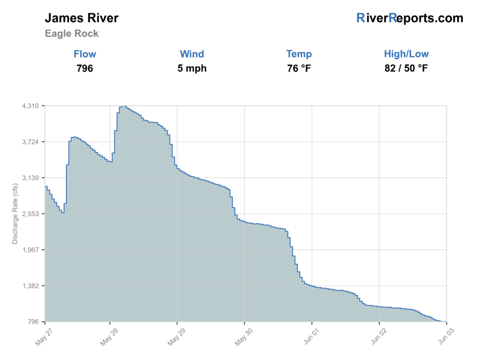
USGS data chart
Official USGS trend
Streamflow over the latest USGS reporting window.
Latest
1,160 cfs
Jun 3, 5 PM UTC
Weather
River weather report
Weather can change wading safety, road access, water temperature, hatches, and the best time of day to fish.
Live forecast loads as you reach this section
This keeps the report fast while still using the official National Weather Service forecast point.
Hatches and flies
Hatch chart and fly picks
March to May
Warming smallmouth water, caddis, minnows, crayfish, and bank insects
Clouser, crayfish, hellgrammite, swimming nymph, small popper
June to August
Low-light topwater, cicadas, hoppers, damselflies, and shade-line baitfish
Foam popper, slider, cicada, hopper, baitfish streamer, crayfish
September to November
Cooling water, shad or minnow movement, crayfish, and steady streamer fishing
Baitfish streamer, crayfish, hellgrammite, olive bugger, soft hackle
December to February
Deep winter holding water, midges, small baitfish, and limited warmwater windows
Small streamer, crawfish, black bugger, midge, jig fly
Topwater
Poppers, sliders, foam bugs, cicadas, hoppers, deer-hair divers
Use early, late, around shade, and on stable summer flows.
Streamers
Clouser, deceiver, shad streamer, olive bugger, articulated minnow
Use along current seams, ledges, bridge shade, wood, and deeper banks.
Bottom flies
Crayfish, hellgrammite, jig bugger, carp nymph, small leech
Use when bright sun, cold fronts, or low water push fish down.
Tactics
How to fish it
Choose the float first, then match the fly box to current level and water clarity.
Throw poppers along shade, grass, and ledge pockets during low light.
Use crayfish and hellgrammites through riffle tails and bedrock slots.
Strip baitfish streamers along deeper banks and island cuts.
Avoid Balcony Falls and other hazard sections unless your plan is built for them.
Rigging
Rod, leader, and setup notes
A 6 or 7-weight is ideal for smallmouth poppers and streamers.
An 8 or 9-weight is more realistic for muskie flies.
Carry floating and intermediate lines for ledges, pools, and fall baitfish.
A PFD, shuttle, spare water, and weather plan are required for long floats.
Access
Access and planning notes
Buchanan and Eagle Rock flow
Primary upper James trendWade / float / trail
RiverReports / USGS gauge / float
When to pick it
Start here when flow, clarity, and ledge safety decide the float.
Caution
The gauge does not replace ramp, dam, rapid, takeout, or skill checks.
Iron Gate to Buchanan
Upper warmwater floatWade / float / trail
Float / ramp / shuttle
When to pick it
Use this when the route length, flow, heat, and access all fit the day.
Caution
Long floats increase the cost of storms, low water, or missed exits.
Glasgow, Balcony Falls, and Holcomb Rock context
Hazard and downstream checkWade / float / trail
Float / whitewater / planning
When to pick it
Pick this when skill, weather, and flow support a larger river objective.
Caution
Whitewater, dams, and shuttle gaps make casual improvising a bad plan.
Whitewater and dams make some sections unsuitable for casual floats.
Low flows can turn a long shuttle into hours of dragging.
Check consumption advisories if keeping fish is part of the plan.
Regulations
Check before fishing
Check Virginia DWR freshwater rules, public access information, whitewater hazards, and consumption advisories before fishing the Upper James.
Primary base
Buchanan, Eagle Rock, Lexington, or Glasgow, Virginia
Best day style
Water-trail ramps, float shuttles, ledge wading at safe flows, and whitewater caution
Check first
DWR access, Eagle Rock/Buchanan flow, storms, water clarity, whitewater, and advisories
Safety
Long shuttles, Balcony Falls whitewater, dams, low-water dragging, heat, and storms
Gear
Helpful gear for this water
Six or seven-weight rod
Handles poppers, streamers, bass current, and wind.
Floating line
Covers most smallmouth topwater, streamer, and crayfish work.
Intermediate line
Helpful on deeper ledges, channels, and fall baitfish windows.
PFD and shuttle plan
Use one for floats, tidal water, and bigger river days.
Sun and heat plan
Carry water, sun protection, and a backup when summer water warms.
Nearby water
Other water to research
Backup logic
High or muddy water
Compare the middle James, Jackson River, or Lower Jackson instead of forcing a poor-visibility float.
Low dragging water
Shorten the float, choose bank water, or wait for better flow.
Whitewater or shuttle problem
Use a simpler reach or move to a less technical river.
Heat
Fish early, carry water, shorten exposure, or pick a safer plan.
James River
The middle James report around Scottsville and Richmond.
Jackson River
One of the headwater trout rivers above the James.
Lower Jackson River
A tailwater trout alternative below Gathright Dam.
FAQ
Fast answers
Is Upper James River fishable today?
Upper James River looks very fishable right now. The live score is 96/100, based on current flow, weather, public alerts, and the report's planning context. Recheck the linked gauge and forecast before leaving because conditions can change quickly after rain, heat, access changes, or flow swings.
What flow is best for Upper James River?
Use RiverReports and USGS 02019500 at Buchanan/Eagle Rock as the main live trend, with USGS 02025500 at Holcomb Rock as downstream context. Stable moderate flows are best; very low water drags floats, while rising or stained water raises hazard risk.
When should I skip Upper James River?
Skip or shorten the plan when thunderstorms are upstream, whitewater sections are above your skill, the shuttle is not confirmed, heat is excessive, water is muddy, or fish-consumption guidance has not been checked for harvest plans.
Is Upper James River safe to wade right now?
The fishability score is not a wading guarantee. Wade only where your chosen access has safe edges, clear footing, legal entry, and no forced crossings; high, rising, stained, or storm-affected water should be treated conservatively.
What should I check first before fishing Upper James River?
Check Eagle Rock/Buchanan flow, DWR access, storms, water clarity, whitewater hazards, and advisories.
Where should a first-time visitor start on Upper James River?
Start around Buchanan or Eagle Rock with a short, realistic float plan.
Can I wade Upper James River?
Yes on safe ledges and low to moderate flows, but many upper James plans are better from a boat.
What flies should I bring for Upper James River?
Bring the seasonal fly box, then adjust size, weight, and color to the water level, clarity, temperature, and pressure you find.
Sources
Source set for this report
Reviewed 2026-06-01