
Virginia / Southeast
South River
A South River report built around Waynesboro and the lower trout-to-smallmouth corridor, with live flow checks, DWR access maps, and mercury-advisory context.
Image: Generated Shenandoah Valley planning image for South River / BlueStreamFly generated; not exact location / BlueStreamFlyFishability now: South River fishability today
GreatData confidence: High96/100
Fishable now because the live gauge is falling, weather is usable, and no public alert is active.
Flow observed
4:15 PM UTC
Weather observed
5:00 PM UTC
Score calculated
5:24 PM UTC
Why this rating
Flow
Weather
Public alerts
Next 6-12 hours
Improving / hold
A falling gauge and usable weather should keep the next 6-12 hours in play unless tributaries stain or heat builds.
USGS flow
43 cfs
Current trend: flow falling, rating likely holding strong unless weather or clarity changes.
More planning details: flies, flow bands, and live source checks
Fish it today
Start here
Start with the Waynesboro gauge and DWR's named parks, then choose Ridgeview, Constitution, North Park, Grand Caverns, or Grottoes by target species.
Best flow clue
Use the Waynesboro gauge with the exact section in mind. Stable moderate flow is the best shared trout and bass signal.
Skip trigger
Skip town trout sections when water is fast, stained, too warm, or rules are unclear; skip lower floats when flow, storms, or takeouts are uncertain.
Flow decision bands
Stable Waynesboro flow
Stable USGS South River flow is the best signal for readable town trout water and lower smallmouth structure.
Best named-park window
Current DWR section rules, mild weather, clear water, and confirmed park access make the river most useful.
Fast stained urban water
Storm stain, pushy park current, or unsafe crossings should move the trout plan elsewhere.
Wrong target or advisory issue
Consumption-advisory context, warm trout water, or lower-river float uncertainty can make a different river the better call.
USGS flow
43 cfs
Current trend: flow falling, rating likely holding strong unless weather or clarity changes.
Live USGS flow
43 cfs / falling about 12%
Live NWS forecast
75F / Sunny
Water temperature not verified
Heat guidance uses weather and river type unless an official water-temperature value is available.
No NWS alert flag
No active NWS alert was returned for this forecast point.
DWR maps Ridgeview Park, Constitution Park, North Park, Basic Park, Grand Caverns, and Grottoes, so the access plan is much stronger than a generic Shenandoah Valley guess.
The same DWR page also states a fish consumption advisory for all South River species except trout, which needs to stay visible in trip planning.
Smallmouth and sunfish improve downstream, while town sections carry trout-specific rules and seasons that deserve their own treatment.
Use the RiverReports trend for timing, but keep DWR's reach-by-reach regulations as the real route map for the day.
Editorial review
How this report is maintained
This report starts with official regulation, access, flow, weather, and public-water sources, then adds practical planning guidance for fly anglers.
Byline
BlueStreamFly editorial desk
Reviewed by
BlueStreamFly source review
Maintained by
BlueStreamFly
Last material review
2026-06-02
Report confidence
High confidence
89/100
High confidence: RiverReports, USGS Waynesboro flow, Virginia DWR South River access and regulation sources, trout stocking context, fish-consumption advisory support, weather coverage, image disclosure, and route-specific trout-to-smallmouth guidance support the page. Confidence is moderated by reach-to-reach rule changes, advisory context, urban pressure, lower-river private banks, storms, and summer heat.
Regulations
Virginia freshwater regulation, trout-stocking, and advisory sources support the current legal and harvest-check path.
Access
Virginia DWR South River source strongly supports named park and lower-river access planning.
Flow and weather
RiverReports coverage is backed by USGS 01626000 near Waynesboro, and the National Weather Service point supports storm and heat decisions.
Fishing usefulness
The page now separates Waynesboro flow, town trout sections, lower smallmouth water, advisory context, named parks, float decisions, and backup-water choices.
Fishability dashboard and source review
2026-06-02 / material content or source review
RiverReports, USGS 01626000 near Waynesboro, Virginia DWR South River, Virginia freshwater regulation and trout-stocking sources, Virginia fish-consumption advisory sources, National Weather Service data, and image-disclosure sources were checked before updating the current-fishability decision layer.
2026-06-02
Updated South River to the current fishability-page standard with Waynesboro trend bands, named public-park access cards, trout-town versus lower-smallmouth skip cues, advisory-aware backup logic, stable fishability SEO, and confidence signals.
2026-05-27
Published a new South River page with DWR-mapped access, trout-to-smallmouth section guidance, and RiverReports plus USGS flow support.
Angler planning edge
Local details that change the plan
Best for
Waynesboro trout sections, urban greenway fishing, downstream smallmouth and sunfish water
Wade or float
Wade and bank from named parks in town, then treat lower water as a separate warmwater or float-style plan.
Best flows
Use the Waynesboro gauge with the exact section in mind. Stable moderate flow is the best shared trout and bass signal.
When to skip
Skip town trout sections when water is fast, stained, too warm, or rules are unclear; skip lower floats when flow, storms, or takeouts are uncertain.
Local plan
Start with the Waynesboro gauge and DWR's named parks, then choose Ridgeview, Constitution, North Park, Grand Caverns, or Grottoes by target species.
Pressure
Urban parks bring walkers and visibility, while downstream pressure depends more on float timing and access.
Access nuance
DWR gives strong named access, but the fish-consumption advisory and reach-specific trout rules need to stay part of the planning layer.
Backup water
Compare North River, Maury River, or Rapidan River when the South is high, warm, advisory-sensitive, crowded, or the target species does not fit.
About the river
Setting, character, and why it fishes the way it does.
South River is one of Virginia's clearest examples of a split-personality fishery. In and around Waynesboro, springs cool the water enough to create multiple managed trout sections. Downstream, the river broadens into a useful warmwater smallmouth and sunfish system.
Virginia DWR has already done the hard work of naming the useful parks and float starts. That matters because this is not a river where vague advice beats section-specific planning.
The mercury advisory also changes the tone of the page. This is still a good fishing river, but it is one where regulations and public-health context deserve equal billing with tactics.
Target species
Rainbow and brown trout
The headline targets in the managed Waynesboro and Grottoes trout sections.
Smallmouth bass
The key downstream warmwater target from Constitution Park toward Port Republic and below.
Redbreast sunfish and rock bass
Reliable support species anywhere the river starts widening into classic Valley bass habitat.
Reading the water
Stable moderate flow
The best all-around condition for trout presentations in town and for bass structure below.
Low clear flow
Great for stealth in trout water, but you need longer leaders and slower approaches.
Light rise
Can improve lower-river bass activity if the water keeps enough clarity to show seam lines.
Fast stained flow
A skip signal on the urban trout sections and a caution flag on tighter lower-river floats.
Best seasons
Spring
The strongest blended season because trout sections are active and lower smallmouth water starts waking up.
Summer
Fish trout early if conditions allow, then lean into bass and sunfish as the day warms.
Fall
Excellent for lower-river bass and good for cleaner trout water around the managed sections.
Winter
More limited, but town trout sections can still reward short controlled sessions.
Preferred flow source
SOUTH RIVER NEAR WAYNESBORO, VA
RiverReports is the preferred chart source when coverage exists. When a matching USGS gauge exists, keep it open as the official backstop for station data and current hydrograph context.
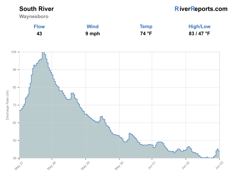
USGS data chart
Official USGS trend
Streamflow over the latest USGS reporting window.
Latest
43 cfs
Jun 3, 4 PM UTC
Weather
River weather report
Weather can change wading safety, road access, water temperature, hatches, and the best time of day to fish.
Live forecast loads as you reach this section
This keeps the report fast while still using the official National Weather Service forecast point.
Hatches and flies
Hatch chart and fly picks
Spring
Minnow movement, crayfish, caddis, and the first dependable smallmouth windows
Clouser, crayfish, olive bugger, soft hackle, popper-dropper
Summer
Terrestrials, low-light topwater, caddis around riffles, and baitfish traffic
Popper, slider, foam beetle, caddis, baitfish streamer
Fall
Crayfish and baitfish-driven feeding with steady streamer windows
Crayfish, bugger, Game Changer, jig streamer, hellgrammite
Winter
Sparse insect activity and slower deep-hold feeding windows
Small streamer, jig bug, midge, dark leech, slow-swung baitfish fly
Topwater
Popper, slider, sneaky Pete, beetle, cicada
Best in low light or under summer shade lines when bass push shallow.
Subsurface
Clouser, crayfish, Game Changer, olive bugger, hellgrammite
The highest-percentage choice around ledges, riffle tails, bridge shade, and deeper slots.
Trout crossover bugs
Stonefly nymph, caddis pupa, egg, zebra midge
Useful on tailwater-influenced or stocked reaches where trout and bass planning overlap.
Tactics
How to fish it
If you are in the town trout sections, fish them like managed trout water with accurate drifts and no assumption that downstream bass patterns still belong.
Below the town reaches, pivot fully into smallmouth structure and stop carrying trout tactics farther than they need to go.
Use DWR's named access points to build short floats or park-based sessions instead of improvising along private banks.
Respect the advisory context and keep the trip centered on sport and release rather than harvest planning.
Rigging
Rod, leader, and setup notes
A 5-weight handles the trout sections well and can still fish lighter bass bugs, while a 6-weight is better if the day is mostly downstream smallmouth water.
Carry 3X to 6X and switch your terminal setup with the section instead of fishing one compromise rig all day.
An indicator kit matters in the trout water; bass bugs and streamers matter more once you are below the town sections.
Wading shoes with solid traction help on greenway and park edges where concrete, gravel, and slick rock can mix awkwardly.
Access
Access and planning notes
Waynesboro gauge
Primary town-flow trendWade / float / trail
RiverReports / USGS gauge / mixed fishery
When to pick it
Start here when flow and clarity decide whether town trout or lower warmwater is realistic.
Caution
The gauge does not replace DWR reach rules, park signs, or consumption-advisory checks.
Ridgeview, Constitution, and North Park
Town trout and greenway accessWade / float / trail
Park / bank / wade
When to pick it
Use these when trout rules, public access, and urban footing all line up.
Caution
Expect public visibility, walkers, bikes, and section-specific regulations.
Grand Caverns and Grottoes
Lower transition and float planningWade / float / trail
Park / bank / float context
When to pick it
Pick these when the plan is broader river water instead of a town trout session.
Caution
Private banks, float distance, and advisory context matter more downstream.
Use DWR's named parks and float map guidance instead of assuming every bridge or bank is the same kind of public start.
The urban corridor gives easy entry, but that also means more walkers, cyclists, and public visibility than a remote trout river.
Below town, private property and longer floats matter more, so do not carry the greenway mindset too far downstream.
Regulations
Check before fishing
Check Virginia DWR South River section rules before fishing. This river has multiple trout management zones plus warmwater sections, and the current mercury advisory matters for every plan.
Primary base
Waynesboro, Ridgeview Park, Constitution Park, and Grottoes
Best day style
Urban-greenway trout access up top and broader wade or float smallmouth water downstream
Check first
Virginia regulations, the 01626000 trend, which South River section you actually plan to fish, and the current fish-consumption advisory
Safety
Urban footing hazards, changing flow, long lower-river floats, and confusing the special trout sections with the bass water downstream
Gear
Helpful gear for this water
5- or 6-weight rod
A 6-weight handles streamers, poppers, and wind better on broad smallmouth rivers.
Wading sandals or shoes with traction
Warmweather trips still demand solid footing on slick ledges and mossy shelves.
PFD for floats
Wear one any time your plan depends on current, deeper pools, or boat access.
Sun and storm kit
Broad valleys and gorge water can turn into a weather-management problem before the bite dies.
Nearby water
Other water to research
Backup logic
Town water is stained or fast
Compare North River or Rapidan River before forcing urban trout water.
Warm trout conditions
Switch target species downstream or stop trout fishing.
Consumption-advisory concern
Read the advisory and adjust harvest or species plans before fishing.
Float or access uncertainty
Stay at named DWR parks or choose Maury River for clearer smallmouth planning.
North River
A strong Augusta County comparison if you want a different trout-to-bass split.
Maury River
A clearer smallmouth-first Virginia option when you want to leave the trout split behind.
Rapidan River
A more trout-specific move if the South River town sections feel too mixed.
FAQ
Fast answers
Is South River fishable today?
South River looks very fishable right now. The live score is 96/100, based on current flow, weather, public alerts, and the report's planning context. Recheck the linked gauge and forecast before leaving because conditions can change quickly after rain, heat, access changes, or flow swings.
What flow is best for South River?
Use the Waynesboro gauge with the exact section in mind. Stable moderate flow is the best shared trout and bass signal.
When should I skip South River?
Skip town trout sections when water is fast, stained, too warm, or rules are unclear; skip lower floats when flow, storms, or takeouts are uncertain.
Is South River safe to wade right now?
The fishability score is not a wading guarantee. Wade only where your chosen access has safe edges, clear footing, legal entry, and no forced crossings; high, rising, stained, or storm-affected water should be treated conservatively.
What should I check before fishing the South River?
Check the Virginia regulations and section maps first, then read the RiverReports trend against USGS 01626000 and decide whether you are fishing one of the trout parks or the lower smallmouth corridor.
Where should I start on the South River?
Start at a DWR-mapped public section such as Ridgeview Park, Constitution Park, North Park, Grand Caverns, or Grottoes depending on whether the day is trout-focused or warmwater-focused.
Can I keep fish from the South River?
Treat the current Virginia Department of Health advisory seriously. The advisory covers all South River species except trout, and trout sections still require the right season and regulation check.
When should I skip the South River?
Skip it when flow is too stained for either trout control or bass structure reading, or when you do not have a clear section choice and start drifting into a mixed-purpose plan.
Sources
Source set for this report
Reviewed 2026-06-02