Tennessee / Southeast
Tellico River
A Tellico Plains report for stocked main-river trout, nearby wild trout tributaries, Tellico River Road access, and current rule checks.
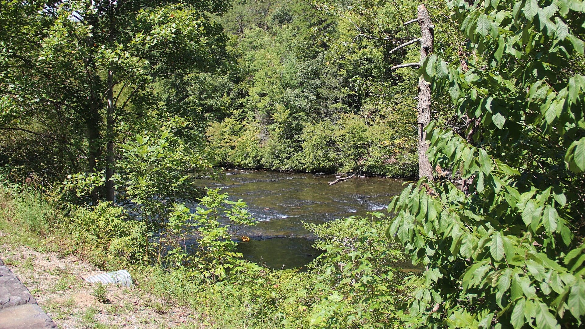
Image: Tellico River, TN Sept 2019 / CC0 / Thomson200Fishability now: Tellico River fishability today
GreatData confidence: High96/100
Fishable now because Tellico Plains gauge is falling, weather is usable, and no public alert is active.
Flow observed
5:00 PM UTC
Weather observed
5:00 PM UTC
Score calculated
5:25 PM UTC
Why this rating
Flow
Weather
Public alerts
Next 6-12 hours
Improving / hold
A falling gauge and usable weather should keep the next 6-12 hours in play unless tributaries stain or heat builds.
USGS flow
134 cfs
Current trend: flow falling, rating likely holding strong unless weather or clarity changes.
More planning details: flies, flow bands, and live source checks
Fish it today
Start here
Start with TWRA rules and trout information, the RiverReports/USGS trend, USFS Tellico access information, weather, and one legal roadside or forest access choice. Fish pocket seams and shaded edges before moving upstream.
Best flow clue
Use RiverReports Tellico River at Tellico Plains with USGS 03518500 as the official backstop. Stable, cool, clear water is best; high or stained water should shift the plan to edges or another river.
Skip trigger
Skip or pivot when storms are pushing the river up, road or parking access is uncertain, water is too warm for trout, or TWRA stocked-water and special-rule details have not been checked.
Flow decision bands
Cool and clear
Stable, cool, clear Tellico Plains flow is the best signal for dry-dropper, nymph, soft-hackle, terrestrial, and small-streamer trout plans.
Best freestone window
A steady or slowly falling RiverReports/USGS trend with current TWRA rules and forest access checked is the cleanest green light.
Rising, stained, or fast
Storm runoff, high stained water, or unsafe pocket-water crossings should move the plan to edges, a shorter check, or another river.
Warm, stocked, or crowded
Warm trout water, stocking-window pressure, campground traffic, or unclear special rules can make the day weaker than the gauge suggests.
USGS flow
134 cfs
Current trend: flow falling, rating likely holding strong unless weather or clarity changes.
Live USGS flow
134 cfs / falling about 22%
Live NWS forecast
78F / Sunny
Water temperature not verified
Heat guidance uses weather and river type unless an official water-temperature value is available.
No NWS alert flag
No active NWS alert was returned for this forecast point.
Check TWRA Tellico-Citico permit and closure rules before choosing a stocked reach.
After rain, wait for the river to drop and clear before wading pocket water.
Dry-droppers and short-line nymphs are usually more useful than long technical rigs.
Nearby tributaries can fish differently than the main river, so do not apply one rule or flow read to every stream.
Editorial review
How this report is maintained
This Tellico River report is maintained from Tennessee Wildlife Resources Agency regulations and trout information, TWRA exception sources, U.S. Forest Service Cherokee National Forest access information, RiverReports and USGS Tellico Plains flow data, weather, media-credit, and mountain freestone planning sources.
Byline
BlueStreamFly editorial team
Reviewed by
BlueStreamFly source review
Maintained by
Mountain Brook Run LLC
Last material review
2026-06-01
Report confidence
High confidence
91/100
High confidence: TWRA regulations, trout information and exceptions, USFS Tellico access information, RiverReports plus USGS Tellico Plains flow, weather coverage, image credit, and route-specific freestone guidance support the page. Remaining variables are storm response, road or parking status, stocked-water timing, pressure, and warm-season trout stress.
Regulations
TWRA regulations, trout information, and exception sources support the current rule-check path.
Access
USFS Cherokee National Forest Tellico River information supports public corridor planning, with road status, pullouts, and exact reach details still requiring current checks.
Flow and weather
RiverReports Tellico Plains flow, USGS 03518500, and the National Weather Service point provide strong live planning support for flow, weather, storm, and safety decisions.
Fishing usefulness
The page now separates stocked versus wild-trout-style planning, flow trend, forest access, pressure, skip cues, and backup-water choices.
Fishability dashboard and source review
2026-06-01 / material content or source review
TWRA fishing regulations, TWRA trout information and exceptions, U.S. Forest Service Cherokee National Forest Tellico River information, RiverReports Tellico Plains flow support, USGS 03518500, the National Weather Service point, and image credit were checked before updating the current-fishability decision layer.
2026-06-01
Updated Tellico River to the current fishability-page standard with Tellico Plains flow bands, forest access cards, backup cues, stable fishability SEO, and confidence signals.
2026-05-28
Added Tellico River Road trip fit, RiverReports-plus-USGS flow planning, stocked-versus-wild-water decision cues, permit and forest-access nuance, warm-water and storm skip cues, backup-water suggestions, editorial review signals, and a page-specific report-confidence meter after source review.
2026-05-25
Initial source-reviewed report published with RiverReports flow support, weather, hatches, flies, tactics, access, regulations, and FAQs.
Angler planning edge
Local details that change the plan
Best for
Cherokee National Forest anglers planning Tellico River Road trout days around TWRA rules, stockings, forest access, and Tellico Plains flow, Nymph, dry-dropper, soft-hackle, terrestrial, and small-streamer days when the freestone water is cool, clear, and stable, Trips where stocked water, tributary wild trout, special rules, forest road access, pressure, and storm flow all need current checks, Anglers comparing Tellico River with Hiwassee River, Little River, or Watauga River before choosing an East Tennessee plan
Wade or float
Treat Tellico as wade-first mountain freestone water. Choose stocked roadside water, tributary-style wild trout, or a higher-gradient pocket-water plan before rigging.
Best flows
Use RiverReports Tellico River at Tellico Plains with USGS 03518500 as the official backstop. Stable, cool, clear water is best; high or stained water should shift the plan to edges or another river.
When to skip
Skip or pivot when storms are pushing the river up, road or parking access is uncertain, water is too warm for trout, or TWRA stocked-water and special-rule details have not been checked.
Local plan
Start with TWRA rules and trout information, the RiverReports/USGS trend, USFS Tellico access information, weather, and one legal roadside or forest access choice. Fish pocket seams and shaded edges before moving upstream.
Pressure
Pressure follows stocking windows, weekends, easy pullouts, and campground traffic. A second legal access choice and smaller presentations usually beat fishing through a crowded pool.
Access nuance
USFS information supports the public corridor, but road status, seasonal closures, parking, camping areas, private boundaries, and exact TWRA reach rules still need current confirmation.
Backup water
If Tellico is high, warm, crowded, or access-limited, compare Hiwassee River for a larger tailwater, Little River for another freestone trout plan, or Watauga River for a technical tailwater option.
About the river
Setting, character, and why it fishes the way it does.
The Tellico River rises in the Cherokee National Forest and becomes a practical fly fishing corridor as it moves toward Tellico Plains. Anglers use Tellico River Road to move between stocked main-river water, camping areas, falls, and tributary options.
The river is useful because it offers several day styles in one drainage: stocked mainstem trout, smaller wild trout water nearby, and scenic access that can be simple when roads are open. It is also easy to overestimate because the same rain that improves streamer fishing can make wading unsafe.
This page keeps the fishing guidance separate from the legal decision. The page can help with flies and tactics, but current TWRA rules, permits, and closures decide where and how you can fish.
Target species
Rainbow trout
Common in stocked main-river opportunities and a practical target for dry-droppers and nymphs.
Brown trout
Possible in the main river and better structure; streamers can matter after safe bumps in flow.
Brook trout
More relevant in small, cold tributary context than in every main-river pullout.
Wild trout tributaries
Treat tributary rules and access separately from stocked Tellico River water.
Reading the water
Low and clear
Use lighter tippet, smaller dries, and keep a low profile around shallow pockets.
Stable moderate flow
Fish dry-droppers through seams, pockets, plunge pools, and boulder edges.
Rising water
Avoid committing to midstream boulders or crossings; the river can change quickly.
Warm afternoons
Use a thermometer and switch to higher, colder water or stop catch-and-release trout fishing if needed.
Best seasons
Spring
Strong stocked-trout and freestone hatch window, but rules and closures need a current check.
Summer
Fish early, use shaded tributary logic, and watch temperature in the main river.
Fall
Cooler water, leaves, and small-stream tactics can be good when flows are stable.
Winter
Nymph slowly in softer water and plan around weather, roads, and stocking/rule updates.
Preferred flow source
Tellico River at Tellico Plains
RiverReports is the preferred chart source when coverage exists. When a matching USGS gauge exists, keep it open as the official backstop for station data and current hydrograph context.
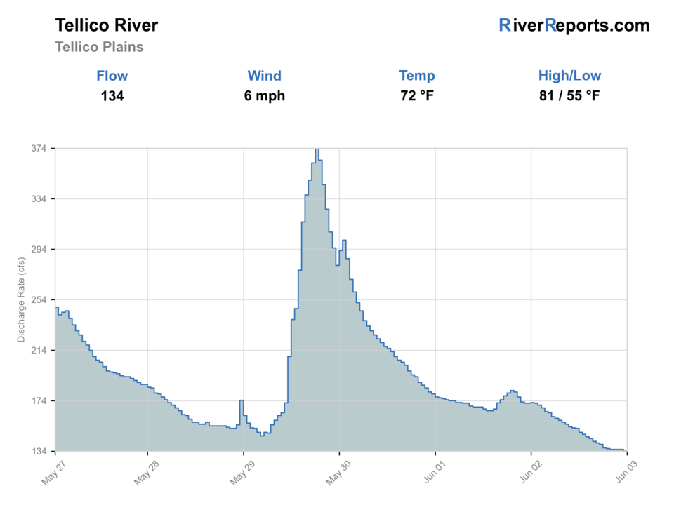
USGS data chart
Official USGS trend
Streamflow over the latest USGS reporting window.
Latest
134 cfs
Jun 3, 5 PM UTC
Weather
River weather report
Weather can change wading safety, road access, water temperature, hatches, and the best time of day to fish.
Live forecast loads as you reach this section
This keeps the report fast while still using the official National Weather Service forecast point.
Hatches and flies
Hatch chart and fly picks
March to April
Early mayflies, little black stones, caddis, and rising freestone trout
Parachute Adams, Blue Quill, black stonefly nymph, caddis pupa, hare's ear
May to June
Yellow sallies, sulphurs, Light Cahills, caddis, and pocket-water attractors
Yellow Sally, sulphur emerger, Light Cahill, elk hair caddis, dry-dropper
July to September
Terrestrials, small stones, beetles, ants, and shaded pocket water
Foam ant, beetle, yellow stimulator, small hopper, green weenie
October to February
BWOs, midges, small stones, and slow winter nymph windows
BWO emerger, zebra midge, stonefly nymph, soft hackle, small bugger
Nymphs
Perdigon, pheasant tail, hare's ear, zebra midge, caddis pupa, stonefly
Use before hatches, in pocket water, or when trout hold near the bottom.
Dries and dry-droppers
Parachute Adams, BWO, caddis, sulphur, ant, beetle, hopper, stimulator
Use during visible rises, pocket-water searching, and low clear water.
Streamers
Sculpin, olive bugger, black bugger, leech, small baitfish
Use after rain, in stained water, and around undercut banks or boulders.
Tactics
How to fish it
Fish upstream through pocket water with short drifts instead of standing in the best seam.
Use a buoyant attractor dry with a beadhead dropper when trout are opportunistic.
Add weight before changing flies if the nymph is not touching bottom in plunge pools.
Use small streamers tight to boulders and undercut edges when the river is safely up and stained.
Keep hatch guidance practical; official sources support rules and stocking, not exact daily insect timing.
Rigging
Rod, leader, and setup notes
A 7.5 to 9-foot 3 to 5-weight handles most Tellico work.
Carry 4X to 6X tippet for dries, nymphs, and clear tributary water.
Use simple dry-dropper rigs in pockets and a compact indicator rig in deeper pools.
Carry split shot, a thermometer, and a wading staff for boulder water.
Access
Access and planning notes
Tellico Plains flow
Primary flow decisionWade / float / trail
RiverReports / USGS gauge / wade
When to pick it
Start here when storm response, clarity, and pocket-water safety decide whether the river is worth the drive.
Caution
The gauge does not replace road, parking, camping, or exact reach checks.
Tellico River Road corridor
Roadside trout planWade / float / trail
USFS / wade / bank
When to pick it
Use this when a legal forest access and short, focused trout plan fit the conditions.
Caution
Road status, pullouts, private boundaries, and crowds still need current confirmation.
Stocked and tributary-style water
Reach selectionWade / float / trail
Wade / small water
When to pick it
Pick this after checking TWRA trout information and deciding whether the day is stocked roadside water or smaller wild-trout-style water.
Caution
Special rules and warm-water stress can change the responsible plan.
Confirm Tellico-Citico permit rules before fishing during the permit season.
Do not assume every pullout is legal or safe; posted land and road conditions still matter.
Rain and narrow roads can turn a simple plan into a high-water safety problem.
Regulations
Check before fishing
Check TWRA statewide rules, fishing regulation exceptions, trout stocking information, and Tellico-Citico permit or closure language before fishing.
Primary base
Tellico Plains, Tennessee
Best day style
Roadside freestone trout water, forest pullouts, campgrounds, and permit-sensitive sections
Check first
TWRA rules and permits, USFS road/access status, flow trend, storms, and water temperature
Safety
Flashy freestone flows, slick boulders, narrow roads, remote cell service, and seasonal closures
Gear
Helpful gear for this water
Four or five-weight rod
Covers most dry-fly, nymph, and dry-dropper work.
Six-weight or streamer rod
Useful for wind, higher water, and larger flies.
Thermometer
Use it before catch-and-release trout fishing in warm weather.
Wading staff
Helpful on freestone rocks, tailwater ledges, and pushy runs.
Barbless-hook box
Speeds handling on wild trout and special-regulation water.
Nearby water
Other water to research
Backup logic
High or stained water
Compare Hiwassee River, Little River, or Watauga River instead of forcing mountain runoff.
Warm trout water
Fish only the coolest responsible window or choose a colder mountain option.
Crowding
Move to a quieter legal pullout or another East Tennessee stream.
Road or rule uncertainty
Confirm USFS access and TWRA reach rules before committing to a roadside plan.
Hiwassee River
A larger East Tennessee tailwater and drift-boat option.
Little River
Smokies freestone trout water with park-rule planning.
Watauga River
A technical East Tennessee tailwater when generation is right.
FAQ
Fast answers
Is Tellico River fishable today?
Tellico River looks very fishable right now. The live score is 96/100, based on current flow, weather, public alerts, and the report's planning context. Recheck the linked gauge and forecast before leaving because conditions can change quickly after rain, heat, access changes, or flow swings.
What flow is best for Tellico River?
Use RiverReports Tellico River at Tellico Plains with USGS 03518500 as the official backstop. Stable, cool, clear water is best; high or stained water should shift the plan to edges or another river.
When should I skip Tellico River?
Skip or pivot when storms are pushing the river up, road or parking access is uncertain, water is too warm for trout, or TWRA stocked-water and special-rule details have not been checked.
Is Tellico River safe to wade right now?
The fishability score is not a wading guarantee. Wade only where your chosen access has safe edges, clear footing, legal entry, and no forced crossings; high, rising, stained, or storm-affected water should be treated conservatively.
What should I check first before fishing Tellico River?
Check TWRA rules and permits, USFS road status, USGS or RiverReports flow, storms, and water temperature.
Where should a first-time visitor start on Tellico River?
Start near Tellico Plains and the Tellico River Road corridor, then match the exact reach to current TWRA rules.
Can I wade Tellico River?
Often, but only when flows are stable and safe. Avoid crossings during rising or stained water.
What flies should I bring for Tellico River?
Bring the seasonal fly box, then adjust size, weight, and color to the water level, clarity, temperature, and fishing pressure you find.
Sources
Source set for this report
Reviewed 2026-06-01