
Tennessee / Southeast
South Fork Cumberland River
A South Fork Cumberland River report for anglers planning the Leatherwood Ford corridor, reading flashy gorge flows, and choosing safe access on the Big South Fork.
Image: Generated regional planning image for South Fork Cumberland River / BlueStreamFly generated; not exact location / BlueStreamFlyFishability now: South Fork Cumberland River fishability today
GoodData confidence: High82/100
Fishable now because Leatherwood Ford gauge is falling, weather is usable, and no public alert is active.
Flow observed
4:30 PM UTC
Weather observed
5:00 PM UTC
Score calculated
5:26 PM UTC
Why this rating
Flow
Weather
Public alerts
Next 6-12 hours
Improving / hold
A falling gauge and usable weather should keep the next 6-12 hours in play unless tributaries stain or heat builds.
USGS flow
931 cfs
Current trend: flow falling, rating likely holding strong unless weather or clarity changes.
More planning details: flies, flow bands, and live source checks
Fish it today
Start here
Start at Leatherwood Ford, confirm NPS access and weather, then choose a short edge-water plan before moving deeper into the gorge.
Best flow clue
Use Leatherwood Ford as the go/no-go signal. Stable or gently falling, clear water with no plateau rain is the best window.
Skip trigger
Skip when water is rising, stained, slick on sandstone, storm-threatened, or when the float/shuttle/exit plan is not clear.
Flow decision bands
Low and clear
Lower, stable Leatherwood Ford flow with clear edges is the best setup for careful smallmouth wading around the public corridor.
Best gorge window
A steady or gently falling gauge, no fresh plateau rain, and a clear exit plan make the river most fishable.
Rising, stained, or tricky current
Rapid rain-driven rises, muddy water, slick sandstone, or uncertain drop-offs should move the day to scouting or another river.
Float-only or no-go
Moderate or high water may require known-reach boat skill, PFD margin, shuttle planning, or a decision not to fish.
USGS flow
931 cfs
Current trend: flow falling, rating likely holding strong unless weather or clarity changes.
Live USGS flow
931 cfs / falling about 58%
Live NWS forecast
78F / Sunny
Water temperature not verified
Heat guidance uses weather and river type unless an official water-temperature value is available.
No NWS alert flag
No active NWS alert was returned for this forecast point.
The National Park Service says Big South Fork follows Tennessee and Kentucky fishing rules and notes reciprocal boat-fishing licenses from Leatherwood Ford downstream to Yamacraw Bridge.
The same park guidance identifies Leatherwood Ford as the main up-close public access area, with the old low-water bridge, boardwalks, riverside benches, and short trails following the river.
NPS also warns that the rocks can be slippery, currents tricky, and drop-offs sudden, which is the right safety lens for anyone tempted to wade deep or force a crossing.
The park's river-gauge page says the Leatherwood Ford gauge is the reference point for most local river descriptions and explains that plateau streams can rise rapidly with little warning after rain.
Editorial review
How this report is maintained
This report starts with official regulation, access, flow, weather, and public-water sources, then adds practical planning guidance for fly anglers.
Byline
BlueStreamFly editorial desk
Reviewed by
BlueStreamFly source review
Maintained by
BlueStreamFly
Last material review
2026-06-02
Report confidence
Good confidence
88/100
Good confidence: RiverReports, USGS Leatherwood Ford flow, Big South Fork NPS fishing, gauge, access, and safety guidance, Tennessee regulations, weather coverage, image disclosure, and route-specific gorge guidance support the page. Confidence is moderated by rapid plateau rises, slick sandstone, remote float logistics, smallmouth timing, and exact day-use conditions.
Regulations
Big South Fork NPS fishing guidance and Tennessee regulations support the current legal-check path.
Access
NPS Leatherwood Ford visitor guidance supports a strong public access framework for the route's core corridor.
Flow and weather
RiverReports coverage is backed by USGS 03410210 at Leatherwood Ford, and NPS river-gauge plus NWS sources support surge and weather decisions.
Fishing usefulness
The page now separates edge-wading, gorge hazards, float-only water, surge risk, access limits, and backup-water choices.
Fishability dashboard and source review
2026-06-02 / material content or source review
RiverReports, USGS 03410210 at Leatherwood Ford, Big South Fork NPS fishing, river-gauge and visitor-access guidance, Tennessee regulations, image-disclosure, and National Weather Service sources were checked before updating the current-fishability decision layer.
2026-06-02
Updated South Fork Cumberland River to the current fishability-page standard with Leatherwood Ford gorge trend bands, NPS access cards, surge-safety backups, stable fishability SEO, and confidence signals.
2026-05-27
Added the first South Fork Cumberland River report for Leatherwood Ford with source-reviewed access, flow, safety, and fly-planning guidance.
Angler planning edge
Local details that change the plan
Best for
Gorge smallmouth sessions, Leatherwood Ford edge fishing, experienced moving-water plans
Wade or float
Wade only the safest public edges at low stable water; higher water needs float skill, PFD margin, or a no-go call.
Best flows
Use Leatherwood Ford as the go/no-go signal. Stable or gently falling, clear water with no plateau rain is the best window.
When to skip
Skip when water is rising, stained, slick on sandstone, storm-threatened, or when the float/shuttle/exit plan is not clear.
Local plan
Start at Leatherwood Ford, confirm NPS access and weather, then choose a short edge-water plan before moving deeper into the gorge.
Pressure
The main day-use area is obvious, while remote water reduces pressure but raises safety and exit requirements.
Access nuance
NPS access is strong, but sudden drop-offs, slick ledges, and remote movement make safety the first filter.
Backup water
Compare Duck River or a calmer warmwater option when Leatherwood Ford is muddy, rising, or unsafe to enter.
About the river
Setting, character, and why it fishes the way it does.
This route is intentionally narrower than the whole Big South Fork drainage. It focuses on the South Fork Cumberland River where the Leatherwood Ford RiverReports chart, the official USGS gauge, and the strongest public-access language overlap.
Big South Fork is a gorge river with far more consequence than many soft-bank warmwater streams. Even when the water looks manageable from the parking area, current lanes, shelves, and drop-offs can change quickly once you step off the edge.
Because the park gives anglers a real public corridor at Leatherwood Ford, the most honest fly-fishing plan is to use that access first, then consider a float or a different reach only after the flow and weather clearly support it.
Target species
Smallmouth bass
The primary fly target for most anglers on the Leatherwood Ford corridor, especially around current seams, ledges, and lower-light windows.
Rock bass
A common supporting target in softer edges and pocket water when smallmouth are scattered.
Muskellunge
Part of the broader Big South Fork fish community, but a specialty target rather than the core plan for most fly days.
Mixed sunfish and catfish
Useful context for summer warmwater sessions, though not the main reason most fly anglers stop at Leatherwood Ford.
Reading the water
Low clear summer flow
Best for careful edge wading, short streamer work, and reading the easier current tongues around Leatherwood Ford.
Moderate stable flow
Good for swinging bigger streamers, covering bank structure, and float planning if you already know the reach and logistics.
Rising or stained water
Treat as a warning sign because plateau rivers can jump fast; stay shallow, shorten the session, or skip it.
Very high water
Do not force wading or casual bank scrambling when the gauge and weather say the gorge is surging.
Best seasons
Spring
Productive when flows settle between rain events, but also the season when the gauge can move fastest.
Summer
Best for low-light smallmouth fishing when the river drops into its clearer, wadable edge pattern.
Fall
Often the cleanest planning window, with stable levels, active warmwater fish, and less heat stress.
Winter
Possible on warmer stable days, but cold water, slick rock, and surge risk keep this a selective call.
Preferred flow source
South Fork Cumberland River at Leatherwood Ford
RiverReports is the preferred chart source when coverage exists. When a matching USGS gauge exists, keep it open as the official backstop for station data and current hydrograph context.
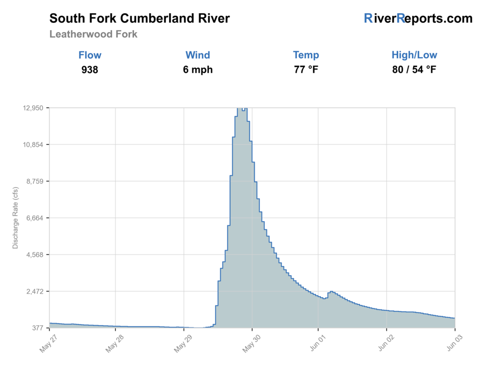
USGS data chart
Official USGS trend
Streamflow over the latest USGS reporting window.
Latest
931 cfs
Jun 3, 4 PM UTC
Weather
River weather report
Weather can change wading safety, road access, water temperature, hatches, and the best time of day to fish.
Live forecast loads as you reach this section
This keeps the report fast while still using the official National Weather Service forecast point.
Hatches and flies
Hatch chart and fly picks
March-May
Crawfish, minnows, and mixed spring insect windows
Clouser, woolly bugger, crayfish bug, black stonefly nymph
June-August
Terrestrials and baitfish-driven warmwater feeding
Poppers, sliders, foam bugs, baitfish streamers
September-October
Baitfish and crayfish feeding windows
Olive streamer, crawdad pattern, bugger, small popper
Late fall-winter
Sparse insects and slower subsurface feeding
Leech, bugger, small jig streamer, stonefly nymph
Smallmouth streamers
Clouser Minnow, olive bugger, black bugger, leech-style streamer
The best first choice when the river has current but little surface activity.
Topwater bugs
Poppers, sliders, deer-hair bugs, foam terrestrials
Best on summer mornings and evenings when bass move into softer bank lanes.
Crayfish patterns
Rust craw, brown craw, weighted buggy crayfish
Useful around ledges, shallow boulder shelves, and slower drops.
Tactics
How to fish it
Start from Leatherwood Ford and fish the obvious public corridor before considering any bigger move.
On lower to moderate flow, work streamers across current seams, shelf edges, and the softer water below structure.
When summer flow is very low, keep the day to early and late windows and cover shade before open slick water.
If rain is in the forecast or the gauge is trending hard, treat the day as flow reconnaissance rather than a committed wade plan.
Do not make a hero crossing here; the park's own guidance is that current, slick rock, and sudden drop-offs are real hazards.
Rigging
Rod, leader, and setup notes
A 6-weight with a floating line covers most Leatherwood Ford bass and streamer work.
Carry 0X through 3X leaders for streamers and topwater bugs around current and rock.
A short sink-tip helps only when you are intentionally probing deeper lanes at safe flows.
Sticky soles and a wading staff matter here more than extra fly boxes.
Access
Access and planning notes
Leatherwood Ford gauge
Primary gorge decisionWade / float / trail
RiverReports / USGS gauge / wade / float
When to pick it
Start here because the same gauge drives the page's flow, access, and safety decision.
Caution
Plateau streams can rise fast; the gauge does not replace radar or an exit check.
Leatherwood Ford Day Use Area
Main public accessWade / float / trail
NPS / bank / wade
When to pick it
Use it when the day is a short public edge-water plan around the bridge, boardwalks, and trails.
Caution
Public access does not make slick rock, sudden drop-offs, or tricky current harmless.
Big South Fork float context
Experienced moving-water planWade / float / trail
Float / shuttle / PFD
When to pick it
Pick this only when flow, skill, launch, takeout, and weather all support it.
Caution
Do not turn a public day-use stop into an unplanned remote river trip.
This page does not assume broad walk-anywhere access outside the Leatherwood Ford public corridor.
If you plan to float, confirm flows, shuttle logistics, and the exact reach before launching.
Use the park corridor for honest access and skip any entry that is not clearly public.
Regulations
Check before fishing
Check the current Tennessee Fishing Guide before fishing because statewide limits, reciprocal-license details, and any species-specific rules can change.
Primary base
Oneida, Rugby, or a Big South Fork day built around Leatherwood Ford rather than a long search for unverified pull-offs
Best day style
Public park access around Leatherwood Ford with short bank and wade opportunities, plus float planning when flows and skill match
Check first
RiverReports, USGS 03410210, Big South Fork river-gauge guidance, Tennessee regulations, and the latest weather forecast
Safety
Rapid rain-driven rises, slick sandstone, tricky current, sudden drop-offs, and remote gorge travel with limited bailout options
Gear
Helpful gear for this water
6-weight rod
The best all-around choice for streamers, poppers, and mixed warmwater work in current.
Wading staff
Important because the park specifically warns about slippery rock and sudden drop-offs.
PFD for float plans
Required thinking whenever you move beyond the day-use access and into true river travel.
Rain shell and dry bag
Plateau storms can change conditions quickly even when the day starts calm.
Nearby water
Other water to research
Backup logic
Rising or muddy water
Move to Duck River, a calmer warmwater option, or a sightseeing day instead of forcing Leatherwood Ford.
Unsafe footing
Stay on bank-access water or leave; slick sandstone and sudden drop-offs are hard-stop hazards.
Float logistics unclear
Skip the float unless shuttle, PFD, skill, and takeout are all settled.
Storm risk
Avoid committing to a gorge session when rain is upstream or building on the plateau.
Clear Fork
A major Big South Fork tributary that changes the main river and deserves its own flow check before mixed-reach plans.
New River
Another tributary that can affect South Fork Cumberland conditions when rain is uneven across the plateau.
Duck River
A different Tennessee warmwater plan when you want a less gorge-heavy bass day.
FAQ
Fast answers
Is South Fork Cumberland River fishable today?
South Fork Cumberland River looks fishable right now. The live score is 82/100, based on current flow, weather, public alerts, and the report's planning context. Recheck the linked gauge and forecast before leaving because conditions can change quickly after rain, heat, access changes, or flow swings.
What flow is best for South Fork Cumberland River?
Use Leatherwood Ford as the go/no-go signal. Stable or gently falling, clear water with no plateau rain is the best window.
When should I skip South Fork Cumberland River?
Skip when water is rising, stained, slick on sandstone, storm-threatened, or when the float/shuttle/exit plan is not clear.
Is South Fork Cumberland River safe to wade right now?
The fishability score is not a wading guarantee. Wade only where your chosen access has safe edges, clear footing, legal entry, and no forced crossings; high, rising, stained, or storm-affected water should be treated conservatively.
Which gauge should I check for South Fork Cumberland River?
Use RiverReports for quick trend checks and keep USGS 03410210 at Leatherwood Ford open as the official backstop for this route.
Can I wade this river safely at any normal-looking flow?
No. The park warns that rocks are slippery, currents tricky, and drop-offs sudden, so the gauge trend and your comfort level should decide whether you wade at all.
Is Leatherwood Ford the best public access for this route?
Yes. It is the strongest official public corridor in the source set and the access point this page is intentionally built around.
What species should fly anglers expect here?
Smallmouth bass lead the plan, with rock bass and other warmwater species as regular supporting catches and musky as a specialty possibility.
Sources
Source set for this report
Reviewed 2026-06-02