
New York / Northeast
West Branch Delaware River at Walton
An upper West Branch Delaware report for anglers checking Walton-area freestone conditions, DEC public-fishing-rights access, and stocked-plus-wild trout planning above Cannonsville Reservoir.
Image: Generated regional planning image for West Branch Delaware River at Walton / BlueStreamFly generated; not exact location / BlueStreamFlyFishability now: West Branch Delaware River at Walton fishability today
GreatData confidence: High96/100
Fishable now because Walton gauge is falling, weather is mild, and no public alert is active.
Flow observed
3:45 PM UTC
Weather observed
4:00 PM UTC
Score calculated
4:21 PM UTC
Why this rating
Flow
Water temperature
Public alerts
Next 6-12 hours
Improving / hold
A falling gauge and usable weather should keep the next 6-12 hours in play unless tributaries stain or heat builds.
USGS flow
187 cfs
Current trend: flow falling, rating likely holding strong unless weather or clarity changes.
More planning details: flies, flow bands, and live source checks
Fish it today
Start here
Base in Walton or Delhi, confirm a legal PFR stretch, then fish one or two access zones well instead of driving between every bridge.
Best flow clue
Stable moderate flow with a little depth and cover but not so much water that every seam is pushy or muddy.
Skip trigger
Skip the Walton plan when recent rain has the upper branch rising fast, the water is muddy, or summer temperatures push trout toward stress.
Flow decision bands
Stable medium Walton flow
This is the cleanest signal for stocked-plus-wild trout nymphing, dry-droppers, and careful short wades above Cannonsville.
Rain rise or muddy freestone water
A rising hydrograph or dirty water should move the plan to soft banks, waiting, or the lower tailwater.
Low bright upper branch
Fish shaded cover with lighter rigs and fewer casts, then stop when temperature or pressure makes trout handling questionable.
Access-map mismatch
A fishable gauge is not enough if the exact Public Fishing Rights reach, parking, or private bank is unclear.
USGS flow
187 cfs
Current trend: flow falling, rating likely holding strong unless weather or clarity changes.
Live USGS flow
187 cfs / falling about 16%
Live NWS forecast
72F / Sunny
Live water temperature
62F from USGS
No NWS alert flag
No active NWS alert was returned for this forecast point.
DEC's West Branch public-fishing-rights map notes the upper river above Cannonsville as stocked water with wild brown trout mixed in.
This route is intentionally separate from the famous colder tailwater below Cannonsville covered on the broader West Branch page.
Moderate flow and a light stain often fish better here than ultra-low clear water because the upper branch is smaller and easier to overpressure.
Use the Walton gauge and DEC access map before assuming every bridge or roadside opening gives practical legal fishing room.
Editorial review
How this report is maintained
This report starts with official regulation, access, flow, weather, and public-land sources, then adds practical planning guidance for fly anglers.
Byline
BlueStreamFly editorial desk
Reviewed by
BlueStreamFly source review
Maintained by
BlueStreamFly
Last material review
2026-06-02
Report confidence
Good confidence
89/100
Good confidence: RiverReports, USGS 01423000 at Walton, NYSDEC regulations, Public Fishing Rights sources, weather coverage, and upper West Branch freestone guidance support the page. Confidence is moderated by exact PFR boundaries, private banks, rain-driven color, low-water pressure, and summer temperature stress.
Regulations
NYSDEC freshwater regulation and 2026 guide sources support current rule checks.
Access
NYSDEC Public Fishing Rights sources support legal access planning, while exact signs, parking, and private-bank boundaries remain day-specific.
Flow and weather
RiverReports, USGS 01423000 at Walton, and the National Weather Service point support live flow and weather decisions.
Fishing usefulness
The page now separates Walton flow, PFR access, rain stain, stocked-plus-wild trout tactics, warm-water restraint, and Delaware-system backups.
Fishability dashboard and source review
2026-06-02 / material content or source review
RiverReports, USGS 01423000 at Walton, NYSDEC freshwater regulations, NYSDEC Public Fishing Rights sources, National Weather Service point data, and upper West Branch freestone planning sources were checked before updating the current-fishability decision layer.
2026-06-02
Added the current-fishability dashboard with Walton flow bands, DEC Public Fishing Rights access cards, rain and warm-water backup cues, stable fishability SEO, and confidence signals.
2026-05-26
Published a new upper West Branch Delaware report focused on Walton freestone conditions, legal access, stocked-plus-wild trout planning, and conservative summer decisions.
Angler planning edge
Local details that change the plan
Best for
Upper Catskills freestone trout, Roadside public-access sessions, Stocked-plus-wild trout nymphing and dry-dropper days
Wade or float
Wade only. The Walton branch is a short-range freestone river where bank access, pocket water, and conservative crossings matter more than any float plan.
Best flows
Stable moderate flow with a little depth and cover but not so much water that every seam is pushy or muddy.
When to skip
Skip the Walton plan when recent rain has the upper branch rising fast, the water is muddy, or summer temperatures push trout toward stress.
Local plan
Base in Walton or Delhi, confirm a legal PFR stretch, then fish one or two access zones well instead of driving between every bridge.
Pressure
The upper branch is less famous than the tailwater, but the easiest roadside water still fishes small and gets seen quickly.
Access nuance
The public-fishing-rights map matters because the upper branch mixes good public access with plenty of private-bank frontage.
Backup water
The lower West Branch tailwater, lower East Branch tailwater, or Esopus Creek are better backup options when the upper freestone branch is too warm or unstable.
About the river
Setting, character, and why it fishes the way it does.
The West Branch Delaware near Walton is the upper branch above Cannonsville Reservoir, not the famous Deposit-to-Hale Eddy tailwater. That difference changes everything about the plan: this is a rain-sensitive freestone with smaller holding water and a more practical stocked-plus-wild trout mindset.
Because the reach sits in a valley with roadside pull-offs and public-fishing-rights sections, anglers can piece together a simple day without drifting miles. The tradeoff is that legal access and smart seam selection matter more than big-river coverage.
This page stays focused on the Walton corridor so the advice matches what a visiting angler can actually verify from DEC access maps, the gauge, and the weather on the day they fish.
Target species
Brown trout
A core upper-branch target in stocked and wild fish mixes, especially around cover and darker seams.
Rainbow trout
Possible in the branch system and worth checking faster riffles and run heads.
Brook trout
More likely in colder tributary influence or upper drainage context than every main corridor run.
Reading the water
Stable medium flow
The best all-around window for nymphing, soft hackles, and simple dry-dropper fishing.
Higher colored water
Fish soft banks, inside bends, and wood-lined edges instead of trying to force the center current.
Low bright water
Go lighter and smaller, then stay low around the most obvious pools and bridge runs.
Summer warmth
Fish early, carry a thermometer, and move to colder water if trout stress looks likely.
Best seasons
Spring
A practical window for stocked-plus-wild trout and active nymph fishing once the river clears.
Early summer
Good when flows settle and evening bugs show on the softer seams.
Summer
Best on cool mornings or cloudy days with enough flow and temperature margin.
Fall
Often the cleanest upper-branch mix of cool water, lower weeds, and less traffic.
Preferred flow source
West Branch Delaware River at Walton
RiverReports is the preferred chart source when coverage exists. When a matching USGS gauge exists, keep it open as the official backstop for station data and current hydrograph context.
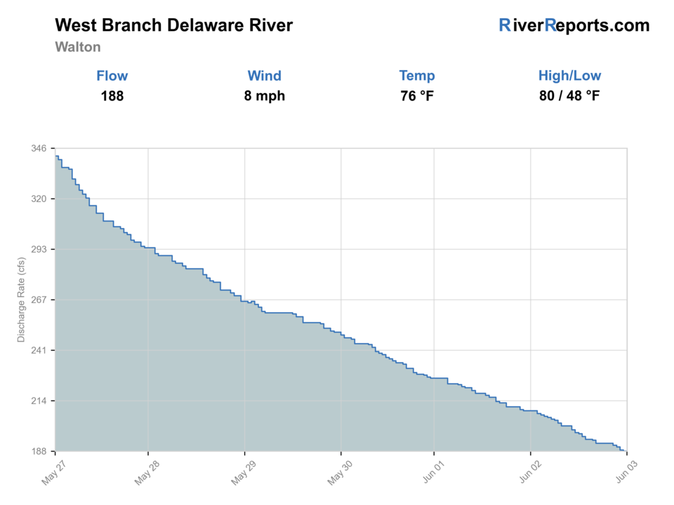
USGS data chart
Official USGS trend
Streamflow over the latest USGS reporting window.
Latest
187 cfs
Jun 3, 3 PM UTC
Weather
River weather report
Weather can change wading safety, road access, water temperature, hatches, and the best time of day to fish.
Live forecast loads as you reach this section
This keeps the report fast while still using the official National Weather Service forecast point.
Hatches and flies
Hatch chart and fly picks
April-May
Midges, black stones, Hendricksons, caddis, and blue-winged olives
Zebra midge, black stonefly nymph, Hendrickson, BWO emerger, caddis pupa
May-June
March Browns, sulphurs, cahills, caddis, and Green Drakes
March Brown, sulphur emerger, light cahill, X-caddis, Green Drake cripple
July-August
Tricos, olives, ants, beetles, and summer caddis
Trico spinner, BWO, foam ant, beetle, elk hair caddis
September-November
BWOs, Isonychia, October caddis, and streamer windows
BWO emerger, Isonychia dry, October caddis, zebra midge, olive bugger
Freestone nymphs
Pheasant tail, hare's ear, caddis pupa, zebra midge, prince nymph
Start here when the river is cool, slightly colored, or fish are holding below pocket water.
Dry flies
Hendrickson, sulphur, parachute Adams, elk hair caddis, ant
Use when trout start sliding into seams, soft edges, or evening riffles.
Streamers
Olive bugger, black bugger, mini sculpin, leech
Use after rain bumps, under cloud cover, or around darker bank structure.
Soft hackles
Partridge and orange, pheasant tail soft hackle, olive soft hackle
Swing riffle tails and current tongues when caddis or mayflies are moving.
Tactics
How to fish it
Read the upper branch as a short-range river: pocket heads, cut banks, and first soft seams matter more than hero casts.
If the water has a little color, fish nymphs and small streamers tight to bank structure before waiting on a surface hatch.
In low water, cover less water and make fewer better drifts instead of hopping between bridges.
When recent rain has the river up, treat the best-looking edge water as the real target and ignore the middle.
Rigging
Rod, leader, and setup notes
A 9-foot 4- or 5-weight is the cleanest one-rod answer for Walton.
Carry 4X to 6X tippet so you can shift from slightly colored freestone water to low bright evening conditions.
A short indicator setup or dry-dropper rig usually fits better than a heavy tailwater nymph system.
Keep a wading staff in the truck for rain-bump days and algae-coated bridge approaches.
Access
Access and planning notes
Walton gauge and town corridor
Flow and clarity checkWade / float / trail
RiverReports / USGS / road scout / wade
When to pick it
Start here when the gauge and visible clarity support a focused upper-branch session.
Caution
Bridge visibility does not confirm legal fishing access.
DEC Public Fishing Rights reaches
Legal upper-branch accessWade / float / trail
PFR / walk-wade
When to pick it
Use them when the PFR map and signs give a clear bank-walking corridor.
Caution
PFR is a fishing easement, not blanket access to adjacent private land.
Delhi and upper valley checks
Rain and reach comparisonWade / float / trail
Road scout / short wade
When to pick it
Pick a legal reach that has better color, depth, and cover than the most obvious town water.
Caution
The upper branch fishes small; pressure and private banks can compress the real options.
The public-fishing-rights map is the best access filter on the upper West Branch.
Roadside convenience can make the first visible run the most pressured run.
Do not confuse the upper branch above the reservoir with the more famous lower tailwater access and flow profile.
Regulations
Check before fishing
Check the current NYSDEC freshwater regulations and 2026 guide before fishing. If you move from the Walton branch to the lower tailwater, confirm the exact rules for each reach instead of treating them as one river.
Primary base
Walton, Delhi, Andes, or Deposit
Best day style
Roadside public-fishing-rights water with short wades, stocker-and-wild trout tactics, and rain-sensitive flows
Check first
RiverReports, USGS 01423000, DEC public-fishing-rights maps, the current NYSDEC regulation guide, and the NWS forecast
Safety
Rain-driven rises, slick cobble, roadside parking hazards, summer trout-temperature stress, and private-bank boundaries
Gear
Helpful gear for this water
4- or 5-weight rod
A versatile choice for Catskills freestone trout water and short-range mends.
Wading staff
Worth carrying whenever recent rain has the pocket water pushing harder than expected.
Thermometer
Useful in summer when smaller upper-branch water warms faster than tailwater anglers expect.
Studded or sticky-rubber boots
Helps on algae, slick cobble, and polished bank rock.
Nearby water
Other water to research
Backup logic
High or muddy Walton water
Compare the lower West Branch tailwater, lower East Branch, or Esopus before forcing upper freestone water.
Warm trout water
Fish only a cool short window or shift to colder tailwater influence.
PFR or parking uncertainty
Confirm the DEC map and signs first or choose a simpler access route.
Low clear pressure
Use smaller flies, fish shade, or move to a less concentrated Delaware-system option.
Delaware River, West Branch
The colder Cannonsville tailwater page when you want the lower branch instead of the Walton freestone water.
Delaware River, East Branch
A nearby Catskills branch option with different tailwater behavior below Pepacton.
Esopus Creek
A different Catskills trout backup when the upper West Branch is too skinny or unstable.
FAQ
Fast answers
Is West Branch Delaware River at Walton fishable today?
West Branch Delaware River at Walton looks very fishable right now. The live score is 96/100, based on current flow, weather, public alerts, and the report's planning context. Recheck the linked gauge and forecast before leaving because conditions can change quickly after rain, heat, access changes, or flow swings.
What flow is best for West Branch Delaware River at Walton?
Stable moderate flow with a little depth and cover but not so much water that every seam is pushy or muddy.
When should I skip West Branch Delaware River at Walton?
Skip the Walton plan when recent rain has the upper branch rising fast, the water is muddy, or summer temperatures push trout toward stress.
Is West Branch Delaware River at Walton safe to wade right now?
The fishability score is not a wading guarantee. Wade only where your chosen access has safe edges, clear footing, legal entry, and no forced crossings; high, rising, stained, or storm-affected water should be treated conservatively.
Is the Walton page the same as the famous West Branch Delaware tailwater?
No. This page covers the upper West Branch above Cannonsville Reservoir near Walton, while the broader West Branch page covers the colder tailwater below the reservoir.
Why use the Walton gauge first?
Because this upper branch reacts faster to rain and summer heat than the lower tailwater, so the Walton reading is the clearest first check for whether the freestone plan makes sense.
When is Walton a better plan than the lower West Branch?
It is a good choice when you want a shorter freestone day with public-bank access and moderate flow, not a technical tailwater dry-fly commitment.
Sources
Source set for this report
Reviewed 2026-06-02