New York / Northeast
Neversink River
A Catskill Neversink report for Bridgeville flows, upper and lower river access, wild trout, hatches, tactics, safety, and regulations.
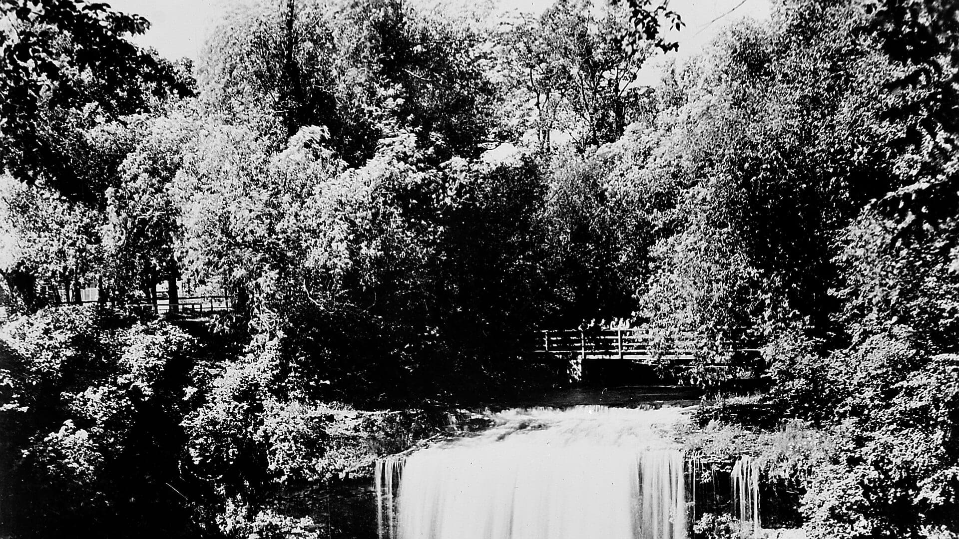
Image: Neversink River waterfalls, New York State, 1942 Wellcome M0008503 / CC BY 4.0 / https://wellcomeimages.org/indexplus/obf_images/2c/a1/61a1d43c944a5287db0b86af023b.jpg Gallery: https://wellcomeimages.org/indexplus/image/M0008503.html Wellcome Collection gallery (2018-03-29): https://wellcomecollection.org/works/nypdb9gk CC-BY-4.0Fishability now: Neversink River fishability today
GreatData confidence: High96/100
Fishable now because Bridgeville gauge is stable, weather is usable, and no public alert is active.
Flow observed
3:30 PM UTC
Weather observed
4:00 PM UTC
Score calculated
4:21 PM UTC
Why this rating
Flow
Water temperature
Public alerts
Next 6-12 hours
Hold
Stable live data supports staying with the plan, but recheck the gauge and forecast before leaving.
USGS flow
130 cfs
Current trend: flow stable, so weather, temperature, and access checks drive the next change.
More planning details: flies, flow bands, and live source checks
Fish it today
Start here
Start with the Bridgeville gauge, current weather, and one reach choice: upper wild-trout water, lower PFR water, or a deliberate Unique Area hike. Fish pocket seams, pool tails, and shaded banks rather than trying to sample every access.
Best flow clue
Use RiverReports and USGS 01436690 at Bridgeville together for the lower-river plan. Stable cool flows are best; sharp rises, stained water, warm afternoons, or pushy gorge current should move the plan to easier water.
Skip trigger
Skip or pivot when thunderstorms are nearby, the gorge is rising or hard to exit, water is too warm for trout handling, public access is uncertain, or current New York trout rules for the exact reach are not confirmed.
Flow decision bands
Low and technical
Low clear Neversink water can still fish, but longer leaders, quieter approaches, and patient trout presentations matter more than jumping from pool to pool.
Best settled Bridgeville trend
Stable cool Bridgeville flow is the cleanest signal for dry-fly, nymph, and dry-dropper plans on the lower river and nearby legal trout reaches.
Storm-rising or unsafe
Storm spikes, pushy crossings, or slick gorge water should cut off the hike-in idea early instead of turning a trout day into a rescue problem.
Heat or access-limited
A fishable graph still becomes a poor trout call when summer warmth builds or Unique Area and posted-bank access details are unclear.
USGS flow
130 cfs
Current trend: flow stable, so weather, temperature, and access checks drive the next change.
Live USGS flow
130 cfs / stable
Live NWS forecast
75F / Sunny
Live water temperature
58F from USGS
No NWS alert flag
No active NWS alert was returned for this forecast point.
Use the Bridgeville gauge for the lower trout plan and check upstream gauges for headwater context.
DEC separates upper wild sections, stocked-extended sections, and catch-and-release water.
Carry Catskill dry flies, small nymphs, and a few streamers for stained or higher water.
Treat the Unique Area as a hike-in trip, not a roadside stop.
Editorial review
How this report is maintained
This Neversink River report is maintained from RiverReports and USGS Bridgeville flow data, New York inland trout regulations, DEC Neversink trout fishing and Unique Area access sources, trout-stream map guidance, weather, media-credit, and Catskill tailwater and gorge planning sources.
Byline
BlueStreamFly editorial team
Reviewed by
BlueStreamFly source review
Maintained by
Mountain Brook Run LLC
Last material review
2026-05-31
Report confidence
Good confidence
89/100
Good confidence: RiverReports, USGS Bridgeville flow, New York trout regulations, DEC Neversink guidance, Unique Area access context, trout-stream map support, and weather back the page. Confidence is moderated by hike-in risk, private-bank details, and storm-driven flow swings.
Regulations
New York inland trout stream rules, DEC Neversink guidance, and trout-stream map context support the legal-check path.
Access
Unique Area access guidance and trout-stream map support the planning framework, while exact legal entry, posted banks, and hike safety still require field checks.
Flow and weather
RiverReports Neversink River at Bridgeville, USGS 01436690, and the National Weather Service point provide a strong live planning set.
Fishing usefulness
The page now separates lower-river trend, gorge safety, legal-access choice, trout-temperature caution, and backup-water decisions.
Fishability dashboard and source review
2026-05-31 / material content or source review
RiverReports Neversink River at Bridgeville, USGS 01436690, New York inland trout regulations, DEC Neversink trout fishing information, Neversink River Unique Area access context, trout-stream map guidance, and the National Weather Service point were checked before updating the current-fishability decision layer.
2026-05-31
Updated Neversink River to the current fishability-page standard with tailwater-and-gorge flow bands, access cards, backup cues, stable fishability SEO, and confidence signals.
2026-05-28
Added Catskill tailwater and gorge trip fit, Bridgeville flow planning, wade and hike-in skip cues, access nuance, backup-water suggestions, editorial review signals, and a page-specific report-confidence meter after source review.
2026-05-25
Initial source-reviewed report published with flows, weather, hatches, flies, tactics, access, regulations, and FAQs.
Angler planning edge
Local details that change the plan
Best for
Catskill trout anglers deciding between upper forks, lower tailwater, and Neversink River Unique Area gorge water, Trips where Bridgeville flow, legal access, storm timing, trout temperature, and hike-in safety all matter, Dry-fly, dry-dropper, nymph, wet-fly, terrestrial, and small-streamer windows when flows are stable and cool, Anglers comparing the Neversink with Esopus Creek, Willowemoc Creek, or Delaware tailwaters before choosing a Catskill plan
Wade or float
Treat the Neversink as wade-first trout water with a separate hike-in plan for the Unique Area. The lower tailwater can look inviting, but gorge access, slick boulders, posted banks, and storm rises should decide how far you go.
Best flows
Use RiverReports and USGS 01436690 at Bridgeville together for the lower-river plan. Stable cool flows are best; sharp rises, stained water, warm afternoons, or pushy gorge current should move the plan to easier water.
When to skip
Skip or pivot when thunderstorms are nearby, the gorge is rising or hard to exit, water is too warm for trout handling, public access is uncertain, or current New York trout rules for the exact reach are not confirmed.
Local plan
Start with the Bridgeville gauge, current weather, and one reach choice: upper wild-trout water, lower PFR water, or a deliberate Unique Area hike. Fish pocket seams, pool tails, and shaded banks rather than trying to sample every access.
Pressure
Pressure follows Catskill hatch windows, famous pools, and easy access. Quiet footwork and a backup reach usually matter more than changing flies repeatedly.
Access nuance
DEC trout-fishing, Unique Area, and trout-stream map sources support planning, but posted banks, parking, trail conditions, and exact legal corridors still need current field confirmation.
Backup water
If the Neversink is high, warm, crowded, or access-limited, compare Esopus Creek for another Catskill mountain-water option, Willowemoc Creek for classic trout water, or the Delaware East Branch for tailwater influence.
About the river
Setting, character, and why it fishes the way it does.
The Neversink is one of the historic Catskill trout rivers tied closely to American fly fishing. It starts in cold mountain country, is split by Neversink Reservoir, and then becomes a lower tailwater before moving toward the Delaware system.
A good day here starts with geography. The upper East and West Branches offer small wild trout water, while the lower river has stocked and wild brown trout, catch-and-release water, and the remote Neversink River Unique Area.
The lower river's cold release can protect trout in warm weather, but rain, reservoir operations, and summer heat still matter. Check flow, temperature, rules, and access before hiking in.
Target species
Brown trout
The main lower-river trout target, especially in pools, banks, and deeper runs.
Brook trout
Most important in the colder upper forks and tributary-influenced water.
Rainbow trout
Present in some stocked and managed sections; check current reach rules.
Smallmouth bass
More relevant farther downstream and in warmer lower-river context.
Reading the water
Low and clear
Lengthen leaders, use smaller dries or nymphs, and keep a low profile.
Stable medium flow
Dry-dropper rigs, Catskill dries, and nymphs can all work.
High or stained
Fish edges with streamers only where wading is safe, or wait for the river to settle.
Summer warmth
Check temperature; move to colder legal water or stop trout fishing when fish are stressed.
Best seasons
Spring
Classic Catskill hatch season with Hendricksons, BWOs, caddis, and rising trout after flows settle.
Early summer
Sulphurs, cahills, caddis, and evening spinner falls can be strong.
Summer
Morning terrestrials and tailwater temperature checks drive the plan.
Fall
Cool water, BWOs, October caddis, and streamer days improve.
Preferred flow source
Neversink River at Bridgeville
RiverReports is the preferred chart source when coverage exists. When a matching USGS gauge exists, keep it open as the official backstop for station data and current hydrograph context.
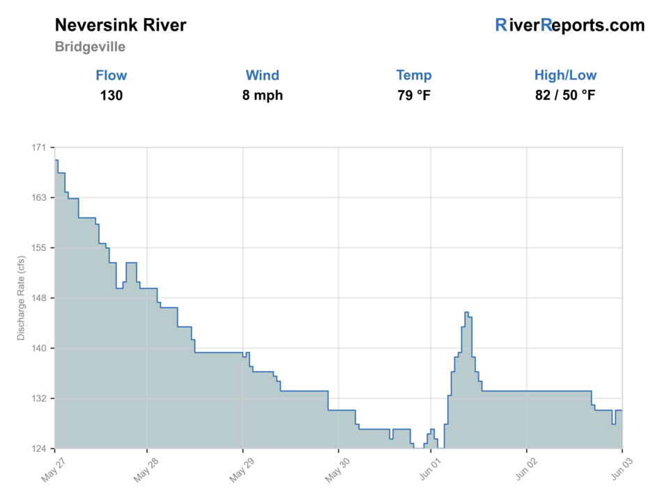
USGS data chart
Official USGS trend
Streamflow over the latest USGS reporting window.
Latest
130 cfs
Jun 3, 4 PM UTC
Weather
River weather report
Weather can change wading safety, road access, water temperature, hatches, and the best time of day to fish.
Live forecast loads as you reach this section
This keeps the report fast while still using the official National Weather Service forecast point.
Hatches and flies
Hatch chart and fly picks
April to early May
Midges, early black stones, Hendricksons, BWOs, and caddis
Zebra midge, black stonefly nymph, Hendrickson, BWO emerger, caddis pupa
Mid-May to June
March Browns, Gray Fox, sulphurs, cahills, caddis, and Green Drakes
March Brown, Gray Fox, sulphur emerger, light cahill, coffin fly spinner
July to August
Tricos, olives, isonychia, ants, beetles, hoppers, and summer caddis
Trico spinner, BWO, isonychia, foam ant, beetle, small hopper
September to November
BWOs, isonychia, October caddis, midges, and streamer windows
BWO emerger, isonychia dry, October caddis, zebra midge, sculpin streamer
Nymphs
Pheasant tail, hare's ear, caddis pupa, zebra midge, perdigon
Use when trout are low, current is broken, or the hatch has not started.
Dry flies
BWO, caddis, parachute Adams, sulphur, terrestrial
Use when fish rise, bugs collect in soft seams, or shaded banks are active.
Streamers
Sculpin, leech, woolly bugger, small baitfish
Use in stain, cloud cover, higher water, or deeper edge water.
Soft hackles
Partridge and orange, pheasant tail soft hackle, caddis soft hackle
Swing riffles, tailouts, and current tongues when insects are moving.
Tactics
How to fish it
Pick the reach first: upper wild water, lower PFR water, or the Unique Area.
Watch the water before casting; clear Catskill trout punish sloppy approach.
Nymph pocket seams and riffle heads before the hatch starts.
Use Catskill dry-fly patterns when fish rise in tailouts and soft edges.
Carry a small streamer for stained water, but do not force unsafe wading.
Rigging
Rod, leader, and setup notes
A 4-weight is useful in the upper forks; a 5-weight is better for the lower river.
Use 9 to 12 foot leaders, extending longer in clear pools.
Carry 4X through 6X tippet for dry-fly and small-nymph work.
Use a short stout leader for streamers when the river has safe color.
Bring a wading staff for the lower river and a real hiking plan for the gorge.
Access
Access and planning notes
Bridgeville gauge and lower-river check
Primary trout decisionWade / float / trail
Gauge / scout
When to pick it
Start here when the lower-river trend decides whether the Neversink should stay on the table at all.
Caution
The gauge is useful, but it does not settle every upstream fork, posted bank, or gorge crossing.
Neversink Unique Area hike-in plan
Dedicated gorge sessionWade / float / trail
Hike / walk-and-wade
When to pick it
Use it when weather, footing, and daylight all support a deliberate hike-in trout plan instead of a quick roadside stop.
Caution
Treat slick boulders, storms, and longer exit time as full fishability limits, not minor inconveniences.
Public-rights and upper-reach option
Shorter trout backupWade / float / trail
Walk-and-wade / scout
When to pick it
Pick it when you want a shorter legal trout session without committing to the gorge.
Caution
Reach-specific rules and private-bank edges still matter even where the access looks straightforward.
DEC notes upper access along Frost Valley, Denning, and Claryville roads.
Lower-river access includes PFR, public lands, county and municipal lands, and private land with signs.
The Unique Area requires a real hike over rough ground; do not plan it like a roadside pool.
Regulations
Check before fishing
NYSDEC lists separate Neversink reach categories including Wild, Stocked-Extended, and Catch-and-Release water. Confirm the exact reach before fishing.
Primary base
Claryville, Bridgeville, Monticello, or Roscoe
Best day style
Forest Preserve, PFR easements, county lands, and remote gorge hiking
Check first
Bridgeville flow, exact reach rules, water temperature, PFR access, and gorge weather
Safety
Rapid storm rises, rough gorge trails, limited service, slick boulders, and posted banks
Gear
Helpful gear for this water
4-weight or 5-weight rod
Covers most dry-fly, nymph, and small-streamer work.
Thermometer
Important for summer trout ethics and reach selection.
Wading staff
Useful on slick cobble, ledge rock, and higher water.
Public-access map
Helps avoid posted land and makes the day more efficient.
Nearby water
Other water to research
Backup logic
High or stormy water
Wait for the Neversink to settle or compare Willowemoc Creek or another Catskill river with a simpler safety profile.
Warm water
Fish only cool windows and stop trout handling when summer warmth removes the coldwater margin.
Access issue
Move to another legal reach instead of guessing at posted banks or forcing a marginal Unique Area hike.
Crowding or hike risk
Turn the day into a shorter public-rights session or another river before stacking more pressure into one gorge plan.
Willowemoc Creek
A nearby Catskill freestone with classic dry-fly history.
Delaware River, East Branch
A tailwater alternative when the Neversink is too warm or storm-affected.
Esopus Creek
A different Catskill plan with portal and turbidity checks.
FAQ
Fast answers
Is Neversink River fishable today?
Neversink River looks very fishable right now. The live score is 96/100, based on current flow, weather, public alerts, and the report's planning context. Recheck the linked gauge and forecast before leaving because conditions can change quickly after rain, heat, access changes, or flow swings.
What flow is best for Neversink River?
Use RiverReports and USGS 01436690 at Bridgeville together for the lower-river plan. Stable cool flows are best; sharp rises, stained water, warm afternoons, or pushy gorge current should move the plan to easier water.
When should I skip Neversink River?
Skip or pivot when thunderstorms are nearby, the gorge is rising or hard to exit, water is too warm for trout handling, public access is uncertain, or current New York trout rules for the exact reach are not confirmed.
Is Neversink River safe to wade right now?
The fishability score is not a wading guarantee. Wade only where your chosen access has safe edges, clear footing, legal entry, and no forced crossings; high, rising, stained, or storm-affected water should be treated conservatively.
What should I check before fishing the Neversink River?
Check Bridgeville flow, water temperature, exact DEC reach category, and whether your access is public.
Are there special regulations on the Neversink River?
Yes. DEC reach categories change by section, so the rules are not the same from the upper forks to the lower gorge.
Can I wade the Neversink River?
Often, but the gorge and lower river can become unsafe after storms. Use the gauge and skip crossings when flows rise.
What flies should I bring for the Neversink River?
Bring the seasonal hatch box, a nymph box, a few streamers, and a backup plan for clear, high, warm, or crowded water.
Sources
Source set for this report
Reviewed 2026-05-31