
Idaho / West
Trail Creek
A reach-focused Trail Creek page for anglers deciding whether the Sun Valley side still has enough cold flow, cover, and public pull-off access for a worthwhile small-stream session.
Image: Generated regional planning image for Trail Creek near Sun Valley / BlueStreamFly generated; not exact location / BlueStreamFlyFishability now: Trail Creek fishability today
GreatData confidence: High96/100
Fishable now because the live gauge is stable, weather is mild, and no public alert is active.
Flow observed
3:30 PM UTC
Weather observed
4:00 PM UTC
Score calculated
4:20 PM UTC
Why this rating
Flow
Weather
Public alerts
Next 6-12 hours
Hold
Stable live data supports staying with the plan, but recheck the gauge and forecast before leaving.
USGS flow
167 cfs
Current trend: flow stable, so weather, temperature, and access checks drive the next change.
More planning details: flies, flow bands, and live source checks
Fish it today
Start here
Check the gauge at dawn, start at Boundary or the trailhead, fish one short section cleanly, and keep Big Wood or Silver Creek ready as the real second stop.
Best flow clue
Post-runoff moderate levels that still cover undercuts and pocket water while staying clear enough to fish with light tackle.
Skip trigger
Skip when the creek turns hot, flat, or so thin that every fishable seam is obvious before you make the first cast.
Flow decision bands
Healthy Sun Valley flow
Stable or slowly falling Sun Valley flow is the best clue that the upper-to-mid creek still has fishable pocket water and cover.
Low clear technical water
Low clear flow can still reward first-light dry-dropper fishing, but the session should be short and careful.
High or dirty runoff
If the creek is rising or dirty, its small-water value drops quickly and the Big Wood is usually the better comparison.
Heat and visibility
Warm bright conditions shrink the fishable window even when the chart still shows some water.
USGS flow
167 cfs
Current trend: flow stable, so weather, temperature, and access checks drive the next change.
Live USGS flow
167 cfs / stable
Live NWS forecast
65F / Mostly Sunny
Water temperature not verified
Heat guidance uses weather and river type unless an official water-temperature value is available.
No NWS alert flag
No active NWS alert was returned for this forecast point.
Idaho Fish and Game lists Trail Creek as a Big Wood tributary in Blaine County and recent stocking records show recurring triploid rainbow plants.
The Sun Valley gauge at USGS 13137300 is the cleanest official check for whether this reach still has enough shape to fish responsibly.
Sawtooth National Forest access is anchored by Boundary Campground and the Trail Creek Trailhead, both immediately above the Sun Valley edge.
The same Big Wood tributary rule set applies here: winter catch-and-release, a spring closure through the Friday before Memorial Day weekend, and a six-trout limit once the summer season opens.
Editorial review
How this report is maintained
This report uses official regulation, flow, weather, access, and public-land sources first, then adds practical planning guidance for fly anglers.
Byline
BlueStreamFly editorial desk
Reviewed by
BlueStreamFly source review
Maintained by
BlueStreamFly
Last material review
2026-06-02
Report confidence
Good confidence
87/100
Good confidence: RiverReports, USGS 13137300 near Sun Valley, Idaho Fish and Game Trail Creek rules, Sawtooth National Forest Boundary and Trail Creek Trailhead sources, Lucy Loken Park, weather coverage, generated media disclosure, and reach-specific small-water guidance support the page. Confidence is moderated by short-session character, rapid heat changes, stocking timing, roadside access nuance, and low clear water.
Regulations
Idaho Fish and Game Trail Creek sources support current Big Wood tributary rule checks.
Access
Sawtooth National Forest and City of Ketchum sources support the main public anchors, while roadside quality and exact pull-off choices remain day-specific.
Flow and weather
RiverReports, USGS 13137300 near Sun Valley, and the National Weather Service point support live flow and weather decisions.
Fishing usefulness
The page now separates the Sun Valley gauge, upper access anchors, short-session timing, low-water heat stops, stocking expectations, and Big Wood or Silver Creek backups.
Fishability dashboard and source review
2026-06-02 / material content or source review
RiverReports and USGS 13137300 Sun Valley flow, Idaho Fish and Game Trail Creek rules, Sawtooth National Forest Boundary Campground and Trail Creek Trailhead access, Lucy Loken Park access, National Weather Service data, and route-specific Sun Valley small-water guidance were checked before updating the current-fishability decision layer.
2026-06-02
Updated Trail Creek near Sun Valley to the current fishability standard with Sun Valley gauge trend bands, access cards, backup cues, stable fishability SEO, and confidence signals.
2026-05-26
Published a new Sun Valley reach page for Trail Creek with gauge-specific timing, official access anchors, and short-session planning guidance.
Angler planning edge
Local details that change the plan
Best for
Short morning small-stream sessions, Sun Valley backup plans, Anglers who like precise dry-dropper and pocket-water fishing
Wade or float
Wade only. This reach is built for short legal walk-ins and careful creek presentations, not boats.
Best flows
Post-runoff moderate levels that still cover undercuts and pocket water while staying clear enough to fish with light tackle.
When to skip
Skip when the creek turns hot, flat, or so thin that every fishable seam is obvious before you make the first cast.
Local plan
Check the gauge at dawn, start at Boundary or the trailhead, fish one short section cleanly, and keep Big Wood or Silver Creek ready as the real second stop.
Pressure
Pressure stays light compared with the Wood River's headline waters, but a small amount of angling traffic can still change a tiny public reach quickly.
Access nuance
Public entry is straightforward at the official sites, but quality habitat is limited, so success comes from picking the right 200 yards rather than walking the whole creek.
Backup water
If the Sun Valley reach is too low or warm, move to Big Wood for more current or Silver Creek for a steadier technical plan.
About the river
Setting, character, and why it fishes the way it does.
Trail Creek rises east of Sun Valley and runs through a tight mountain-valley corridor before joining the Big Wood system. The Sun Valley reach is the part most anglers can sample quickly from town.
That easy access is both the appeal and the trap. The creek can offer pleasant pocket-water and bank-cover fishing, but it does not stay strong through every warm-weather window.
Treat this page as a reach-specific planning guide for the Sun Valley side, not as a promise that every visible roadside run is worth stopping for.
Target species
Rainbow trout
The most dependable catch in this reach, supported by regular Idaho Fish and Game triploid stocking.
Brook trout
Present in the drainage and a realistic bonus on the colder, brushier upper sections.
Wild small-stream trout mix
Expect fish numbers and size to vary sharply with runoff timing, summer heat, and how recently the reach was stocked.
Reading the water
Post-runoff moderate flow
The best window for pocket-water nymphing, short dry-dropper drifts, and clean bank-cover presentations.
Low clear summer flow
Fish very early, shorten the day, and focus on the deepest bends or overhead cover.
High or dirty runoff
Usually not worth forcing because the creek loses its small-water precision quickly.
Hot bright afternoon
Usually the sign to move to Big Wood, Silver Creek, or a colder higher-elevation backup.
Best seasons
Late spring
Useful once the spring closure has ended and runoff drops enough to reveal pocket structure.
Early summer
Usually the most balanced period for flow, access, and morning dry-dropper fishing.
Mid summer
Still possible at dawn, but heat and low water shorten the responsible fishing window.
Fall
A modest reset when cooler nights improve water temperature and pressure drops.
Preferred flow source
Trail Creek near Sun Valley
RiverReports is the preferred chart source when coverage exists. When a matching USGS gauge exists, keep it open as the official backstop for station data and current hydrograph context.
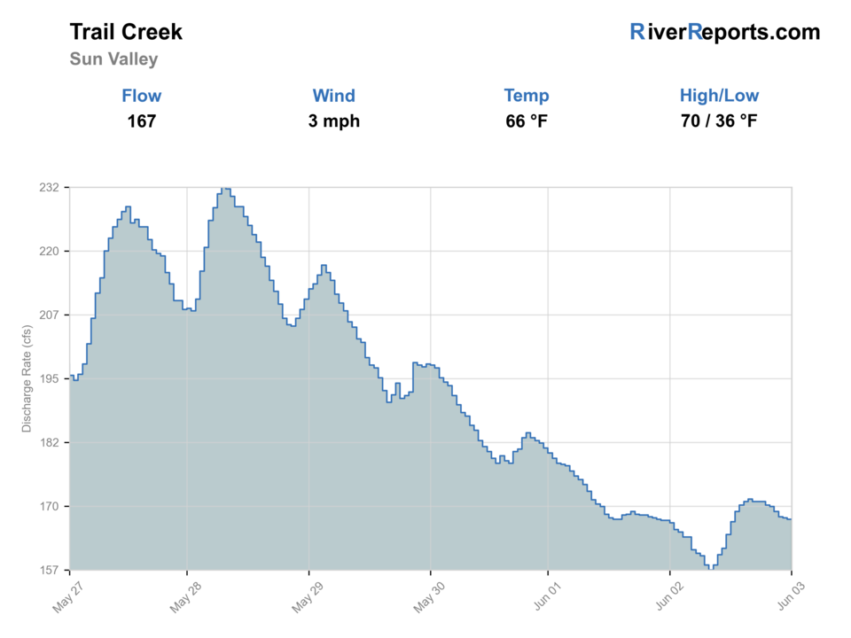
USGS data chart
Official USGS trend
Streamflow over the latest USGS reporting window.
Latest
167 cfs
Jun 3, 4 PM UTC
Weather
River weather report
Weather can change wading safety, road access, water temperature, hatches, and the best time of day to fish.
Live forecast loads as you reach this section
This keeps the report fast while still using the official National Weather Service forecast point.
Hatches and flies
Hatch chart and fly picks
Spring
Midges and early mayflies
Zebra midge, small pheasant tail, BWO emerger
Early summer
Caddis, PMDs, and attractor dry windows
Elk hair caddis, PMD cripple, yellow stimulator
Summer
Terrestrials and small caddis
Foam ant, beetle, hopper, small dropper nymph
Fall
BWOs and midges
Parachute BWO, RS2, zebra midge
Pocket-water nymphs
Pheasant tail, hare's ear, perdigon, zebra midge
The water still has enough push to hide fish on the bottom.
Small attractor dries
Stimulator, elk hair caddis, parachute Adams
Best when fish will rise in broken seams or pocket tails.
Summer dry-dropper
Foam ant, beetle, small hopper, tungsten dropper
Useful on mornings when the creek is clear but still cool enough to fish.
Tactics
How to fish it
Check the Sun Valley gauge first and fish only the sections that still show enough depth, current, and overhead cover.
Make short accurate casts into pockets, undercuts, and the shaded edges of bends instead of covering water mechanically.
If the creek looks warm or glassy by mid-morning, stop and move rather than trying to squeeze value out of water that has gone flat.
Treat every public pull-off as a short targeted stop. The point here is precision, not mileage.
Rigging
Rod, leader, and setup notes
A 3- to 5-weight floating-line setup is enough for the full Sun Valley reach.
Carry 4X through 6X tippet because the creek swings from brushy short drifts to very clear small slicks.
One short nymph leader and one small-stream dry-dropper setup cover most situations.
Good glasses matter because this is a visibility river long before it feels like a flow river.
Access
Access and planning notes
Boundary Campground
Upper first stopWade / float / trail
Forest Service / walk-wade
When to pick it
Start here when the creek still has enough current and you want the cleanest public access near Sun Valley.
Caution
This is a compact access point, not proof that the whole roadside reach is worth fishing.
Trail Creek Trailhead
Trailhead scoutWade / float / trail
Forest Service / short walk
When to pick it
Use it when you want a legal upper check before deciding whether to fish or pivot.
Caution
Low water and trailhead pressure can make a good-looking stop fish smaller than expected.
Lucy Loken Park
Lower quick checkWade / float / trail
City park / town-side look
When to pick it
Pick it when you need a fast lower-creek condition check before driving higher.
Caution
Lower water warms sooner, so do not use this stop alone to green-light the whole reach.
The best public access is concentrated, not continuous. Use the official campground, trailhead, and city park anchors first.
Roadside visibility is high, but not every shoulder is a durable or worthwhile fishing stop. Choose the pieces that still look alive.
This is a short-session creek. Build the day around that reality and keep a larger backup river ready.
Regulations
Check before fishing
Trail Creek follows Idaho Fish and Game's Big Wood River tributary rules upstream of Magic Reservoir: winter catch-and-release, a spring closure through the Friday before Memorial Day weekend, and a six-trout limit once the summer season opens.
Primary base
Sun Valley or Ketchum
Best day style
Walk-wade roadside and trailhead access with short technical sessions instead of all-day mileage
Check first
RiverReports trend, USGS 13137300 near Sun Valley, Idaho Trail Creek rules, and current morning temperature
Safety
Thin late-summer water, slick banks, roadside pull-off traffic, and warm afternoon temperatures
Gear
Helpful gear for this water
3- to 5-weight rod
The right range for compact nymphing, dry flies, and short dry-dropper rigs.
Light pack and fine tippet
This reach rewards mobility and careful presentation more than extra gear.
Thermometer
Useful because the creek can look fishable after temperature has already become the limiting factor.
Compact wading boots
The access is mostly short-hop walking rather than long heavy-river wading.
Nearby water
Other water to research
Backup logic
Creek too thin
Shift to Big Wood or Silver Creek instead of forcing the Sun Valley reach.
Warm afternoon
End the creek session and move to a colder or more stable waterbody.
Runoff pulse
Wait for the creek to fall and clear or compare a larger Wood River valley option.
Busy access
Fish one public anchor carefully, then leave rather than crowding every obvious pull-off.
Trail Creek
The broader Ketchum-focused version of this drainage if you want a less reach-specific page.
Big Wood River
A stronger valley-river backup when you want more durable current and more room to move.
Silver Creek
A steadier spring-creek alternative when Trail Creek gets too small or too warm.
FAQ
Fast answers
Is Trail Creek fishable today?
Trail Creek looks very fishable right now. The live score is 96/100, based on current flow, weather, public alerts, and the report's planning context. Recheck the linked gauge and forecast before leaving because conditions can change quickly after rain, heat, access changes, or flow swings.
What flow is best for Trail Creek?
Post-runoff moderate levels that still cover undercuts and pocket water while staying clear enough to fish with light tackle.
When should I skip Trail Creek?
Skip when the creek turns hot, flat, or so thin that every fishable seam is obvious before you make the first cast.
Is Trail Creek safe to wade right now?
The fishability score is not a wading guarantee. Wade only where your chosen access has safe edges, clear footing, legal entry, and no forced crossings; high, rising, stained, or storm-affected water should be treated conservatively.
What should I check first on Trail Creek near Sun Valley?
Start with RiverReports and USGS 13137300 near Sun Valley, then decide whether the creek still has enough current and temperature margin for a short session.
Is the Sun Valley reach worth a full day?
Usually no. It is better as a short technical stop or a morning backup before moving to a larger or colder river.
Where should I start on this reach?
Boundary Campground and the Trail Creek Trailhead are the cleanest public starting points, with Lucy Loken Park useful for a lower quick check.
Sources
Source set for this report
Reviewed 2026-06-02