
Idaho / West
South Fork of the Boise River
A South Fork Boise River report for the Anderson Ranch tailwater, Neal Bridge rules, canyon access, RiverReports/USGS flows, hatches, flies, and safe wading planning.
Image: Sunrise sunburst over the South Fork of the Boise River - Flickr - Knowles Gallery / CC BY 2.0 / Charles Knowles from Meridian Idaho, USAFishability now: South Fork of the Boise River fishability today
GreatData confidence: High96/100
Fishable now because the live gauge is falling, weather is usable, and no public alert is active.
Flow observed
4:15 PM UTC
Weather observed
5:00 PM UTC
Score calculated
5:27 PM UTC
Why this rating
Flow
Water temperature
Public alerts
Next 6-12 hours
Improving / hold
A falling gauge and usable weather should keep the next 6-12 hours in play unless tributaries stain or heat builds.
USGS flow
1,600 cfs
Current trend: flow falling, rating likely holding strong unless weather or clarity changes.
More planning details: flies, flow bands, and live source checks
Fish it today
Start here
Start with the Anderson Ranch release and the exact legal reach, then decide whether the day fits short wade sessions, a canyon scout, or a boat-supported plan. Bring a backup because access and flows can turn a long drive into a poor trade quickly.
Best flow clue
Use the RiverReports Anderson Ranch chart and USGS 13190500 together. Stable releases create the best technical window; sudden changes, very high water, or low clear water should change the reach, method, or destination.
Skip trigger
Skip the trip when seasonal closures or Neal Bridge reach rules are unclear, when releases make wading unsafe, when canyon roads or weather make access risky, or when crowding concentrates anglers into a few legal pullouts.
Flow decision bands
Low but fishable
Low clear tailwater releases can fish technically, but shallow water, stealth, and safe exits become the limiting factors.
Best canyon tailwater window
Stable Anderson Ranch releases with current Neal Bridge rules checked give the best nymph, streamer, caddis, BWO, and terrestrial signal.
Pushy or unsafe
High or changing releases should move the plan to boats, banks, or another river instead of aggressive wading.
Remote access caution
Canyon roads, ramps, fire restrictions, seasonal closures, and private edges can override a good-looking hydrograph.
USGS flow
1,600 cfs
Current trend: flow falling, rating likely holding strong unless weather or clarity changes.
Live USGS flow
1,600 cfs / falling about 12%
Live NWS forecast
77F / Mostly Sunny
Live water temperature
44F from USGS
No NWS alert flag
No active NWS alert was returned for this forecast point.
Use the Anderson Ranch Dam gauge before committing to wade or float.
Check IDFG Neal Bridge to Anderson Ranch Dam special rules and seasonal closure dates.
Expect a cold tailwater with wild trout, whitefish, and release-driven conditions.
Plan for canyon roads, limited services, and public-land etiquette.
Editorial review
How this report is maintained
This South Fork Boise report is maintained from RiverReports and USGS flow data, Idaho Fish and Game rule sources, public recreation access guidance, weather checks, and Anderson Ranch tailwater planning guidance.
Byline
BlueStreamFly editorial team
Reviewed by
BlueStreamFly source review
Maintained by
Mountain Brook Run LLC
Last material review
2026-05-31
Report confidence
High confidence
91/100
High confidence: RiverReports, USGS 13190500, Idaho Fish and Game rule pages, Recreate Idaho access guidance, and weather data support the page. Confidence is moderated by release changes, seasonal reach rules, road and ramp conditions, fire restrictions, and remote canyon access.
Regulations
Idaho Fish and Game South Fork Boise and Neal Bridge reach pages support current rule checks.
Access
Recreate Idaho and IDFG sources support public planning, while road, ramp, fire, private-edge, and canyon conditions still need current confirmation.
Flow and weather
RiverReports, USGS 13190500, and the National Weather Service point are attached to the route.
Fishing usefulness
The page now separates Anderson Ranch releases, Neal Bridge rules, wade versus boat plans, canyon access, pressure, and Boise or Big Wood backup decisions.
Fishability dashboard and source review
2026-05-31 / material content or source review
RiverReports and USGS Anderson Ranch Dam flow, Idaho Fish and Game South Fork Boise and Neal Bridge rule pages, Recreate Idaho access guidance, and the National Weather Service point were checked before updating the current fishability guidance.
2026-05-31
Updated South Fork Boise with Anderson Ranch release guidance, canyon wade and boat access cards, seasonal-rule cautions, backup cues, stable fishability SEO, and confidence signals.
2026-05-28
Added Anderson Ranch tailwater trip-fit guidance, wade and boat-access framing, seasonal-rule and release skip cues, canyon access nuance, pressure timing, backup-water suggestions, editorial review signals, and a page-specific report-confidence meter after source checks.
2026-05-24
Initial source-reviewed report published with flows, weather, hatches, flies, tactics, access, regulations, and FAQs.
Angler planning edge
Local details that change the plan
Best for
Anglers planning the Anderson Ranch Dam to Neal Bridge tailwater with current rules checked first, Nymph, streamer, caddis, BWO, midge, stonefly, and terrestrial windows when releases are stable, Trips where road access, canyon travel, seasonal closures, boat ramps, and safe wading need to be settled before leaving Boise, Anglers comparing a remote canyon tailwater with the Boise River, Big Wood River, or Silver Creek
Wade or float
Treat the South Fork Boise as a canyon tailwater that can support both focused wade plans and boat-supported days. The better choice depends on releases, road conditions, legal reach, ramp access, and how much remote travel you want to take on.
Best flows
Use the RiverReports Anderson Ranch chart and USGS 13190500 together. Stable releases create the best technical window; sudden changes, very high water, or low clear water should change the reach, method, or destination.
When to skip
Skip the trip when seasonal closures or Neal Bridge reach rules are unclear, when releases make wading unsafe, when canyon roads or weather make access risky, or when crowding concentrates anglers into a few legal pullouts.
Local plan
Start with the Anderson Ranch release and the exact legal reach, then decide whether the day fits short wade sessions, a canyon scout, or a boat-supported plan. Bring a backup because access and flows can turn a long drive into a poor trade quickly.
Pressure
The canyon can feel remote, but productive tailwater access and boat ramps still concentrate anglers during good windows. Early timing, spacing, and a clear exit plan matter.
Access nuance
IDFG and Recreate Idaho sources support the rule and access framework, but road condition, ramp condition, private edges, fire restrictions, and current signs still need trip-specific confirmation.
Backup water
If the South Fork Boise is closed, high, crowded, or access-limited, compare the Boise River, Big Wood River, or Silver Creek after checking current rules, flows, and weather.
About the river
Setting, character, and why it fishes the way it does.
The South Fork of the Boise River is a cold tailwater below Anderson Ranch Dam with canyon access and strong Idaho trout character.
Dam operations make the flow check essential because wading safety and fish position can change with releases.
IDFG special rules make the upper tailwater different from generic Boise River water.
The corridor is popular enough that sanitation, parking, trash, and respectful spacing matter.
Target species
Rainbow and redband trout
The main trout target in the cold tailwater.
Mountain whitefish
Common in runs and riffles and often caught on nymphs.
Bull trout
Present in the system; handle conservatively and check current rules.
Brook trout and kokanee
Part of the broader system context but not always the main fly target.
Reading the water
Moderate stable release
Best for wade plans, nymphs, dry-droppers, and tactical bank work.
High release
Avoid deep wading and consider boat-only tactics where legal and safe.
Low clear water
Use lighter tippet, smaller nymphs, and careful approach angles.
Hot canyon day
Fish early, carry water, and watch trout handling temperatures.
Best seasons
Spring
Check closure dates and flows before planning a tailwater trip.
Summer
PMDs, caddis, stones, and hoppers can be strong when releases are friendly.
Fall
Cooler weather, BWOs, and lower pressure can make excellent windows.
Winter
Catch-and-release rules and cold access shape the plan.
Preferred flow source
South Fork Boise River below Anderson Ranch Dam
RiverReports is the preferred chart source when coverage exists. When a matching USGS gauge exists, keep it open as the official backstop for station data and current hydrograph context.
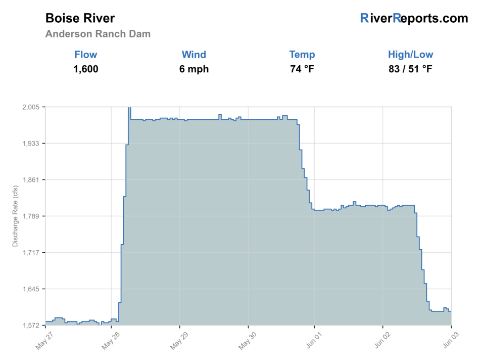
USGS data chart
Official USGS trend
Streamflow over the latest USGS reporting window.
Latest
1,600 cfs
Jun 3, 4 PM UTC
Weather
River weather report
Weather can change wading safety, road access, water temperature, hatches, and the best time of day to fish.
Live forecast loads as you reach this section
This keeps the report fast while still using the official National Weather Service forecast point.
Hatches and flies
Hatch chart and fly picks
Spring
Midges, BWOs, early caddis
Zebra midge, BWO emerger, caddis pupa, pheasant tail
Early summer
PMDs, caddis, golden stones
PMD dry, elk hair caddis, stonefly nymph, chubby
Late summer
Hoppers, ants, caddis
Hopper, ant, beetle, caddis dry, perdigon
Fall
BWOs, midges, October caddis
BWO dry, RS2, zebra midge, October caddis
Tailwater nymphs
Perdigon, pheasant tail, zebra midge, caddis pupa, stonefly
Use in deeper slots, riffles, and cold clear flows.
Dry-droppers
Chubby, hopper, stimulator, tungsten dropper
Use in summer pockets and bank lines at safe flows.
Dries
PMD, BWO, caddis, hopper, ant
Use during visible hatches and bank-focused dry windows.
Streamers
Sculpin, bugger, leech
Use on cloudy days, higher safe flows, or deeper banks.
Tactics
How to fish it
Check the Anderson Ranch release before choosing a wade plan.
Use nymphs in deeper tailwater slots before surface activity starts.
Fish dry-droppers and terrestrials tight to banks in summer.
Avoid crowding popular pullouts and pack out trash.
Know the seasonal closure and barbless/no-bait language before fishing.
Rigging
Rod, leader, and setup notes
A 9-foot 5-weight covers most days.
Use 4X to 6X depending on clarity and fly size.
Bring enough weight for tailwater depth but avoid snag-heavy rigs.
Carry a wading staff for uneven tailwater cobble.
Pack extra water, sun protection, and a road plan.
Access
Access and planning notes
Anderson Ranch release check
Primary tailwater decisionWade / float / trail
Gauge / wade / boat
When to pick it
Start here when release stability decides whether the day fits wading, bank work, or a boat-supported plan.
Caution
A release change can make a safe shoal unsafe before the fishing looks different.
Neal Bridge rule reach
Legal reach checkWade / float / trail
Regulation / wade / bank
When to pick it
Use it before committing to the core tailwater reach.
Caution
Seasonal and reach-specific rules need current confirmation before choosing flies or harvest assumptions.
Canyon roads and ramps
Access logisticsWade / float / trail
Road / ramp / remote scout
When to pick it
Pick this lens when weather, road surface, ramp condition, or fire restrictions will decide the day.
Caution
Remote canyon access leaves less room for improvising if flows or weather change.
The roaded canyon can feel easy until weather, heat, or crowds change the day.
Use official rules for seasonal closures and legal tackle.
High releases can make familiar crossings unsafe.
Keep human waste and trash planning part of the trip.
Regulations
Check before fishing
IDFG lists special South Fork Boise rules for the Neal Bridge to Anderson Ranch Dam reach, including seasonal closure and tackle restrictions. Verify before fishing.
Primary base
Mountain Home, Boise, or Featherville
Best day style
Tailwater road access, boat ramps, canyon pullouts, and remote public-land travel
Check first
Dam release, IDFG special rules, seasonal closures, road conditions, and heat
Safety
Release changes, canyon roads, cold water, remote travel, and limited services
Gear
Helpful gear for this water
Tailwater nymph box
Small mayflies, midges, caddis pupa, and stoneflies cover most subsurface fishing.
Terrestrial dries
Hoppers, ants, and attractors matter in summer canyon water.
Wading staff
Useful when releases are firm or rocks are slick.
Remote day kit
Water, sun protection, and a road plan are part of the South Fork day.
Nearby water
Other water to research
Backup logic
High water
Move to a boat-supported day, compare the Boise River or Big Wood, or wait for Anderson Ranch releases to stabilize.
Heat
Use the cold tailwater advantage but fish early, handle trout quickly, and avoid warm low-water stress.
Storms or road issues
Delay canyon travel when lightning, muddy roads, fire restrictions, or poor ramp access make exits uncertain.
Access issue
Use signed public access and IDFG-supported reaches only; pivot to the Boise, Big Wood, or Silver Creek if the canyon plan is unclear.
Boise River
A more urban Greenbelt option with different access and flow issues.
Big Wood River
A Sun Valley freestone option when tailwater releases are not friendly.
Silver Creek
A technical spring creek alternative near Picabo.
FAQ
Fast answers
Is South Fork of the Boise River fishable today?
South Fork of the Boise River looks very fishable right now. The live score is 96/100, based on current flow, weather, public alerts, and the report's planning context. Recheck the linked gauge and forecast before leaving because conditions can change quickly after rain, heat, access changes, or flow swings.
What flow is best for South Fork of the Boise River?
Use the RiverReports Anderson Ranch chart and USGS 13190500 together. Stable releases create the best technical window; sudden changes, very high water, or low clear water should change the reach, method, or destination.
When should I skip South Fork of the Boise River?
Skip the trip when seasonal closures or Neal Bridge reach rules are unclear, when releases make wading unsafe, when canyon roads or weather make access risky, or when crowding concentrates anglers into a few legal pullouts.
Is South Fork of the Boise River safe to wade right now?
The fishability score is not a wading guarantee. Wade only where your chosen access has safe edges, clear footing, legal entry, and no forced crossings; high, rising, stained, or storm-affected water should be treated conservatively.
Which South Fork Boise gauge should I use?
Use USGS 13190500 below Anderson Ranch Dam, shown with RiverReports and official USGS context.
Are there seasonal closures?
Yes. IDFG lists special seasonal rules for the Neal Bridge to Anderson Ranch Dam reach.
Is this the same as the Boise River in town?
No. This is the South Fork tailwater below Anderson Ranch Dam, not the Greenbelt river through Boise.
Can I wade it safely?
Only at safe releases and legal access points. High releases can make wading dangerous.
Sources
Source set for this report
Reviewed 2026-05-31