
Idaho / West
Henry's Fork
A lower Henry's Fork planning page for the St. Anthony-to-Menan corridor, built around float access, lower-river rules, and realistic decisions about wind, weeds, and side channels.
Image: Generated regional planning image for Henry's Fork near St. Anthony / BlueStreamFly generated; not exact location / BlueStreamFlyFishability now: Henry's Fork fishability today
GreatData confidence: High96/100
Fishable now because St. Anthony gauge is falling, weather is mild, and no public alert is active.
Flow observed
3:45 PM UTC
Weather observed
4:00 PM UTC
Score calculated
4:20 PM UTC
Why this rating
Flow
Weather
Public alerts
Next 6-12 hours
Improving / hold
A falling gauge and usable weather should keep the next 6-12 hours in play unless tributaries stain or heat builds.
USGS flow
1,370 cfs
Current trend: flow falling, rating likely holding strong unless weather or clarity changes.
More planning details: flies, flow bands, and live source checks
Fish it today
Start here
Use the St. Anthony gauge first, pick one access cluster like Red Road or Warm Slough, and commit to a shorter cleaner day instead of chasing miles of similar-looking lower water.
Best flow clue
Stable lower-river flows that keep side channels defined without flooding soft banks or turning weed lanes into constant fouling.
Skip trigger
Skip when hard valley wind, thick weed mats, or crowded launches turn the lower river into a boat-control problem instead of a fishing problem.
Flow decision bands
Stable lower-river flow
Stable 13050500 flow is the best side-channel, bank-edge, and short-float signal.
Launch plan confirmed
Red Road, Warm Slough, Menan, or Beaver Dick access should be selected before rigging.
Wind or weeds
Hard valley wind or heavy weed fouling can turn a fishable level into a poor human day.
High broad water
Higher lower-river flows should push the day toward boats, banks, or another reach.
USGS flow
1,370 cfs
Current trend: flow falling, rating likely holding strong unless weather or clarity changes.
Live USGS flow
1,400 cfs / falling about 26%
Live NWS forecast
61F / Sunny
Water temperature not verified
Heat guidance uses weather and river type unless an official water-temperature value is available.
No NWS alert flag
No active NWS alert was returned for this forecast point.
Use RiverReports first for the public chart, then confirm the lower-river trend with USGS 13050500 at St. Anthony.
IDFG reach lines matter here because the lower corridor carries a simpler two-trout framework than the more restrictive technical water upstream.
BLM and IDFG access sites around Red Road, Warm Slough, and Menan make this a practical float corridor when launches and wind cooperate.
If the river is weedy, windy, or crowded with pleasure traffic, commit to fewer cleaner drifts or move before the day turns into endless repositioning.
Editorial review
How this report is maintained
This report uses official regulation, flow, weather, and public-access sources first, then adds practical planning guidance for fly anglers.
Byline
BlueStreamFly editorial desk
Reviewed by
BlueStreamFly source review
Maintained by
BlueStreamFly
Last material review
2026-06-02
Report confidence
High confidence
90/100
High confidence: RiverReports, USGS 13050500 St. Anthony flow, Idaho Fish and Game Henrys Fork rules, BLM lower-river access, IDFG Warm Slough status, weather coverage, generated media disclosure, and route-specific lower-river guidance support the page. Confidence is moderated by wind, weed load, soft banks, launch crowding, and lower-river shuttle logistics.
Regulations
Idaho Fish and Game Henrys Fork sources support current lower-river and upstream rule checks.
Access
BLM Henrys Fork and IDFG Warm Slough sources provide strong launch and day-use planning anchors, with site status and shuttles still needing checks.
Flow and weather
RiverReports, USGS 13050500 at St. Anthony, and the National Weather Service point support live flow and weather decisions.
Fishing usefulness
The page now separates lower-river flow, launch selection, wind, weeds, side channels, boat-versus-bank decisions, and backup Idaho routes.
Fishability dashboard and source review
2026-06-02 / material content or source review
RiverReports and USGS 13050500 St. Anthony flow, Idaho Fish and Game Henrys Fork rules, BLM Henrys Fork lower-river access, IDFG Warm Slough day-use update, National Weather Service data, and route-specific lower-river wind and weed guidance were checked before updating the current-fishability decision layer.
2026-06-02
Updated Henry's Fork near St. Anthony to the current fishability standard with lower-river flow bands, launch access cards, backup cues, stable fishability SEO, and confidence signals.
2026-05-26
Published a new lower Henry's Fork report for the St. Anthony corridor with launch planning, lower-river rule framing, and wind-and-weed decision guidance.
Angler planning edge
Local details that change the plan
Best for
Lower-river float planning, Summer hopper and nymph days, Anglers who want simpler public access than the upper Henry's Fork
Wade or float
Either can work, but the lower corridor is usually strongest when you think in terms of launch access and short floats instead of trying to wade broad open flats all day.
Best flows
Stable lower-river flows that keep side channels defined without flooding soft banks or turning weed lanes into constant fouling.
When to skip
Skip when hard valley wind, thick weed mats, or crowded launches turn the lower river into a boat-control problem instead of a fishing problem.
Local plan
Use the St. Anthony gauge first, pick one access cluster like Red Road or Warm Slough, and commit to a shorter cleaner day instead of chasing miles of similar-looking lower water.
Pressure
Pressure is lighter than the famed upper Henry's Fork, but easy launches and summer weekends still stack anglers and floaters at obvious access points.
Access nuance
The lower river is public-friendly, but each launch changes the day differently. Warm Slough is not the same style of fishing as Red Road or Menan, and wind can magnify those differences quickly.
Backup water
If the lower Henry's Fork is too weedy or windy, move to the Ashton-focused Henry's Fork route for a different style or switch to the South Fork Snake if you still want a larger drift-day setup.
About the river
Setting, character, and why it fishes the way it does.
This reach of Henry's Fork meanders through a flatter agricultural and cottonwood corridor south of St. Anthony before meeting the South Fork Snake near Menan.
That lower-river shape creates a different kind of fishing than the Ashton or Harriman water: more float logic, more wind exposure, more side channels, and more bank-access decisions tied to public launches.
The St. Anthony gauge is the right planning anchor here because it matches the lower-river flow picture and keeps you honest about whether the day should be a boat day, a short bank session, or a backup-water call.
Target species
Rainbow trout
A core lower-river target, especially around cleaner seams, weed edges, and side-channel structure.
Brown trout
Part of the mixed lower-river trout picture and a reason to keep streamer or bigger nymph options handy.
Cutthroat trout
Present in the fishery, but lower-river harvest restrictions make species identification worth the extra care.
Mountain whitefish
A common bycatch when you are drifting deeper runs or slower inside bends.
Reading the water
Lower steady flow
Best for side-channel scouting, cleaner weed lanes, and manageable bank or boat angles.
Stable medium flow
A good all-around lower-river level if wind and boat traffic stay modest.
High or pushy flow
Focus on launch-to-takeout planning first because the river spreads out and loses easy wading options quickly.
Heavy weed and wind
Downshift expectations, fish sheltered lanes, and avoid pretending every drift needs to be forced.
Best seasons
Late spring
Good once runoff settles enough for side channels and softer seams to fish cleanly.
Summer
A practical float and hopper season, but wind, weeds, and recreational use become bigger factors.
Early fall
Often the cleanest blend of stable weather, lighter crowds, and more deliberate lower-river trout fishing.
Winter
Possible for committed local anglers, but wind and limited soft-water options make it a niche call.
Preferred flow source
Henrys Fork at St. Anthony
RiverReports is the preferred chart source when coverage exists. When a matching USGS gauge exists, keep it open as the official backstop for station data and current hydrograph context.
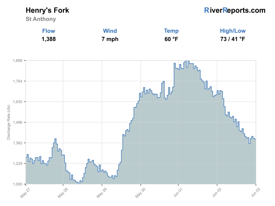
USGS data chart
Official USGS trend
Streamflow over the latest USGS reporting window.
Latest
1,370 cfs
Jun 3, 4 PM UTC
Weather
River weather report
Weather can change wading safety, road access, water temperature, hatches, and the best time of day to fish.
Live forecast loads as you reach this section
This keeps the report fast while still using the official National Weather Service forecast point.
Hatches and flies
Hatch chart and fly picks
Spring
Midges, BWOs, and caddis
Zebra midge, BWO emerger, soft hackle, caddis pupa
Early summer
Caddis, PMDs, and stonefly leftovers
PMD dry, elk hair caddis, prince nymph, rubberlegs
Summer
Caddis, terrestrials, and evening spinner windows
Hopper-dropper, beetle, ant, rusty spinner
Fall
BWOs, midges, and small streamers
Parachute BWO, RS2, zebra midge, olive bugger
Dry-dropper
Hopper, beetle, ant, or foam attractor with a compact nymph
The most practical searching setup for lower-river bank edges and summer side channels.
Nymphs
Pheasant tail, perdigon, prince, zebra midge, caddis pupa
Best when fish hold in deeper current tongues or when wind ruins surface precision.
Terrestrials
Foam hopper, ant, beetle
Strong on calmer summer afternoons around grass-lined banks and side seams.
Small streamers
Leech, bugger, slim sculpin
Useful early, late, or after wind and color knock fish off surface feeding.
Tactics
How to fish it
Pick one access corridor and fish it with purpose instead of trying to sample every launch between St. Anthony and Menan.
Use weed lanes, side channels, and slower bank structure more than the broad flat middle of the river.
Float only if your put-in, take-out, and shuttle are settled before you rig rods.
When wind rises, shorten drifts and fish protected water instead of fighting open straightaways all afternoon.
Rigging
Rod, leader, and setup notes
A 9-foot 5-weight handles most lower-river dry-dropper and nymph work.
Carry one longer leader for calmer dry-fly windows and one shorter stronger setup for wind and hopper rigs.
Bring anchor and boat-control discipline if you float; this corridor fishes poorly when the rower is improvising.
A second rod rigged with a small streamer or indicator saves time when weeds or wind shut down lighter presentations.
Access
Access and planning notes
Red Road Bridge boat access
Lower-river float startWade / float / trail
BLM access / float / bank
When to pick it
Start here when launch, shuttle, wind, and flow all support a controlled lower-river plan.
Caution
This is not the same fishery as the upper Ranch and Ashton water.
Warm Slough access site
Day-use public stagingWade / float / trail
IDFG access / bank / launch
When to pick it
Use it when day-use timing, parking, and side-channel water match a shorter plan.
Caution
Day-use status and seasonal pressure need current confirmation.
Menan and Beaver Dick corridor
Downstream takeout logicWade / float / trail
Public access / float
When to pick it
Pick it when the day needs a deliberate lower-river finish rather than open-ended drifting.
Caution
Wind, soft banks, and shuttle distance can add risk quickly.
BLM's Henry's Fork access page is the cleanest official summary for lower-river launch and takeout choices around St. Anthony and Menan.
Warm Slough remains an important public access, but IDFG's 2025 site note means anglers should treat it as day-use only from February 1 through September 30.
Lower-river access is friendly compared with more remote Idaho fisheries, but wind, weeds, and float timing still punish casual planning.
Regulations
Check before fishing
IDFG's 2025-2027 Henry's Fork rules split the river into multiple sections. The lower reach from the South Fork Snake confluence upstream to Vernon Bridge carries a 2-trout limit with no cutthroat harvest, while upstream reaches shift into more restrictive seasonal and gear rules. Check the current rulebook before choosing your section.
Primary base
St. Anthony, Rexburg, or a lower-river shuttle plan
Best day style
Boat launches, day-use access sites, lower-river bank edges, and short float-friendly reaches
Check first
RiverReports, USGS 13050500, IDFG Henry's Fork rules, launch access, and forecast wind
Safety
Wind, weed mats, side-channel complexity, boat traffic, soft banks, and long lower-river shuttles
Gear
Helpful gear for this water
Wind-ready 5-weight setup
The lower river often asks more from your casting than the upper Henry's Fork does.
Boat or shuttle essentials
Anchor, spare oar, and a clean shuttle plan matter if you float this reach.
Terrestrial and nymph boxes
A simpler lower-river mix is more useful here than hyper-specialized technical dries alone.
Sun and weather layers
The open valley exposes you to heat, wind, and quick weather swings.
Nearby water
Other water to research
Backup logic
Wind
Move to protected bank edges, shorten the float, or compare the Ashton Henry's Fork route.
Weed fouling
Fish cleaner side channels, switch tactics, or move to a different Idaho trout river.
Crowded launches
Choose another confirmed public access or move to Big Wood River for a simpler wade day.
High water
Use boat-only logic or leave the lower river for safer wade water.
Henry's Fork
The Ashton corridor is a better fit when you want technical dry-fly water and section-specific upper-river structure.
South Fork of the Snake River
A stronger big-river drift option if you want a more classic boat day than the lower Henry's Fork offers.
Big Wood River
A better backup when lower-river wind or weeds make you want a simpler wade-focused day.
FAQ
Fast answers
Is Henry's Fork fishable today?
Henry's Fork looks very fishable right now. The live score is 96/100, based on current flow, weather, public alerts, and the report's planning context. Recheck the linked gauge and forecast before leaving because conditions can change quickly after rain, heat, access changes, or flow swings.
What flow is best for Henry's Fork?
Stable lower-river flows that keep side channels defined without flooding soft banks or turning weed lanes into constant fouling.
When should I skip Henry's Fork?
Skip when hard valley wind, thick weed mats, or crowded launches turn the lower river into a boat-control problem instead of a fishing problem.
Is Henry's Fork safe to wade right now?
The fishability score is not a wading guarantee. Wade only where your chosen access has safe edges, clear footing, legal entry, and no forced crossings; high, rising, stained, or storm-affected water should be treated conservatively.
What part of Henry's Fork does this page cover?
This page is built for the lower St. Anthony-to-Menan corridor, not the technical ranch and Ashton water farther upstream.
Is this mostly a wade river or a float river?
It can be both, but the lower river makes the most sense when you plan around public launches, side channels, and a realistic float or bank-access lane.
What gauge should I trust for this reach?
Start with RiverReports and USGS 13050500 at St. Anthony because they match the lower-river corridor far better than the upstream Ashton gauge.
Sources
Source set for this report
Reviewed 2026-06-02