
Idaho / West
Big Lost River
A Big Lost River report for the Mackay tailwater and valley access, RiverReports/USGS flow checks, IDFG rules, whitefish protection, hatches, flies, and dewatering cautions.
Image: Mount McCaleb, Big Lost River / CC BY 2.5 / BLMIdahoFishability now: Big Lost River fishability today
GreatData confidence: High96/100
Fishable now because the live gauge is stable, weather is mild, and no public alert is active.
Flow observed
4:45 PM UTC
Weather observed
5:00 PM UTC
Score calculated
5:24 PM UTC
Why this rating
Flow
Weather
Public alerts
Next 6-12 hours
Hold
Stable live data supports staying with the plan, but recheck the gauge and forecast before leaving.
USGS flow
646 cfs
Current trend: flow stable, so weather, temperature, and access checks drive the next change.
More planning details: flies, flow bands, and live source checks
Fish it today
Start here
Start with the Mackay tailwater and IDFG lower access context, then compare BLM trail or upper Forest Service water only if road, weather, and flow conditions support the extra travel.
Best flow clue
Use the RiverReports Mackay chart and USGS 13127000 together. Stable tailwater releases create the best window; dewatering, sudden irrigation changes, or very low warm water should move you to a different reach or another river.
Skip trigger
Skip the Big Lost when flows are too low for responsible trout handling, when IDFG rules or whitefish language are unclear, when private-bank access is the only realistic entry, or when remote weather and road conditions make the drive a poor trade.
Flow decision bands
Low but fishable
Low clear tailwater or valley flow can fish technically, but dewatering, warm water, and fish-handling restraint become the limiting factors.
Best Mackay window
Stable below-reservoir releases with cool weather and legal public access make the best nymph, dry-dropper, caddis, and terrestrial signal.
Pushy or unsafe
Irrigation swings, high releases, or storm runoff should move the plan to edges or another Idaho trout river.
Dewatering caution
Very low warm water can make the river look approachable while making trout fishing a poor choice.
USGS flow
646 cfs
Current trend: flow stable, so weather, temperature, and access checks drive the next change.
Live USGS flow
646 cfs / stable
Live NWS forecast
63F / Partly Sunny
Water temperature not verified
Heat guidance uses weather and river type unless an official water-temperature value is available.
No NWS alert flag
No active NWS alert was returned for this forecast point.
Use the RiverReports and USGS below-Mackay gauge for the main flow check.
Check IDFG rules, including mountain whitefish special language.
Watch for intermittent dewatering and irrigation effects in lower reaches.
Plan for remote access and limited services away from Mackay.
Editorial review
How this report is maintained
This Big Lost River report is maintained from RiverReports and USGS flow data, Idaho Fish and Game rule and access sources, BLM and Forest Service access references, weather checks, and Mackay tailwater planning guidance.
Byline
BlueStreamFly editorial team
Reviewed by
BlueStreamFly source review
Maintained by
Mountain Brook Run LLC
Last material review
2026-05-31
Report confidence
High confidence
91/100
High confidence: RiverReports, USGS 13127000, IDFG fishing and access sources, BLM trail context, USFS upper-drainage information, and weather data support the page. Confidence is moderated by dewatering, irrigation changes, private banks, whitefish or species rules, and remote travel.
Regulations
IDFG fishing-planner information supports current river rules and species context.
Access
IDFG access, BLM trail, and Forest Service area sources support public planning, with private banks and roads still requiring current checks.
Flow and weather
RiverReports, USGS 13127000, and the National Weather Service point are attached to the route.
Fishing usefulness
The page now separates Mackay releases, dewatering, IDFG/BLM/USFS access, remote travel, warm-water restraint, and Big Wood or Boise backups.
Fishability dashboard and source review
2026-05-31 / material content or source review
RiverReports and USGS Big Lost River below Mackay Reservoir flow, IDFG Big Lost fishing planner and access pages, BLM Big Lost River Access Trail, USFS North Fork Big Lost area, and the National Weather Service point were checked before updating the current fishability guidance.
2026-05-31
Updated Big Lost River with Mackay tailwater guidance, IDFG, BLM, and Forest Service access cards, dewatering cautions, backup cues, stable fishability SEO, and confidence signals.
2026-05-28
Added Mackay tailwater trip-fit guidance, wade-first valley framing, dewatering and whitefish-rule skip cues, BLM and Forest Service access nuance, pressure timing, backup-water suggestions, editorial review signals, and a page-specific report-confidence meter after source review.
2026-05-24
Initial source-reviewed report published with flows, weather, hatches, flies, tactics, access, regulations, and FAQs.
Angler planning edge
Local details that change the plan
Best for
Anglers planning the Mackay Reservoir tailwater and Big Lost valley trout corridor, Nymph, dry-dropper, caddis, BWO, terrestrial, and whitefish-aware fishing when flows remain fishable, Trips where IDFG rules, dewatering risk, public access, and private banks need to be checked before driving, Anglers comparing a remote Idaho valley river with the Big Wood, Boise, and other western trout options
Wade or float
Treat the Big Lost as a wade-first valley and tailwater report. The useful plan is to check flows, pick legal access, and fish deliberate runs on foot rather than expecting a float plan to solve access or dewatering problems.
Best flows
Use the RiverReports Mackay chart and USGS 13127000 together. Stable tailwater releases create the best window; dewatering, sudden irrigation changes, or very low warm water should move you to a different reach or another river.
When to skip
Skip the Big Lost when flows are too low for responsible trout handling, when IDFG rules or whitefish language are unclear, when private-bank access is the only realistic entry, or when remote weather and road conditions make the drive a poor trade.
Local plan
Start with the Mackay tailwater and IDFG lower access context, then compare BLM trail or upper Forest Service water only if road, weather, and flow conditions support the extra travel.
Pressure
Pressure is not usually urban, but productive tailwater and public access spots can feel small when flows are low. Early timing and careful fish handling matter more than covering every road pullout.
Access nuance
IDFG, BLM, and Forest Service sources support public planning, but private banks and water-management changes define many days. Confirm legal entry and current water before committing to a long valley drive.
Backup water
If the Big Lost is dewatered, too warm, or access-limited, compare the Big Wood River, Boise River, or another Idaho trout option after checking current rules and flows.
About the river
Setting, character, and why it fishes the way it does.
The Big Lost River drains central Idaho mountain country and flows through the Mackay valley before losing surface flow in the basin downstream.
Mackay Reservoir strongly influences the below-dam fishery, so the gauge is more useful than a generic seasonal report.
The river includes public access, private banks, BLM recreation sites, and remote upper drainage water with very different trip logistics.
IDFG notes species and special rules that should be checked before handling or targeting fish casually.
Target species
Rainbow trout
A core trout target below Mackay and in suitable valley reaches.
Cutthroat trout
Relevant in the broader drainage and upper coldwater habitat.
Brook trout
More likely in colder tributary or upper-drainage contexts than every main-stem reach.
Mountain whitefish
IDFG special rules can apply, so verify current handling and harvest language.
Reading the water
Low clear flow
Use stealth, smaller flies, and avoid pushing fish in shallow warm water.
Stable medium release
Nymph rigs, dry-droppers, and attractor dries can cover riffles and buckets.
High release
Avoid risky crossings and fish softer banks only where access is legal.
Dewatered reach
Do not force a trout plan; move to water with enough cold flow or use a backup river.
Best seasons
Spring
Pre-runoff and early release windows can be useful before flows rise.
Summer
Caddis, PMDs, stones, and terrestrials matter, but heat and irrigation flows decide the day.
Fall
Cooler water, BWOs, and lower crowds can make this a strong season.
Winter
Cold, access, and ice limit options; check local conditions first.
Preferred flow source
Big Lost River below Mackay Reservoir
RiverReports is the preferred chart source when coverage exists. When a matching USGS gauge exists, keep it open as the official backstop for station data and current hydrograph context.
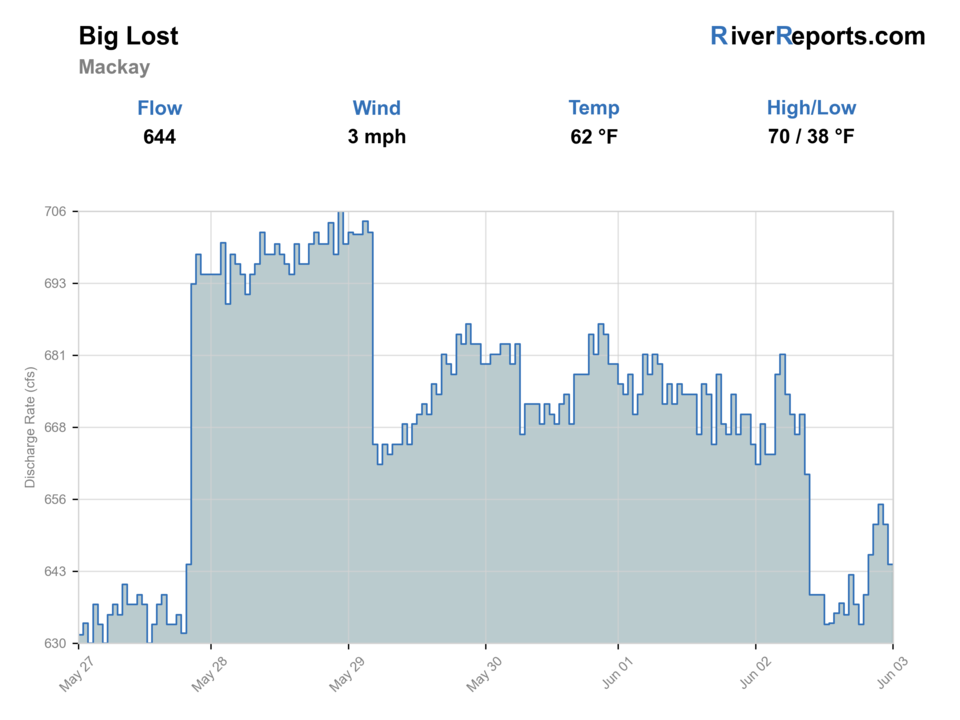
USGS data chart
Official USGS trend
Streamflow over the latest USGS reporting window.
Latest
646 cfs
Jun 3, 4 PM UTC
Weather
River weather report
Weather can change wading safety, road access, water temperature, hatches, and the best time of day to fish.
Live forecast loads as you reach this section
This keeps the report fast while still using the official National Weather Service forecast point.
Hatches and flies
Hatch chart and fly picks
Spring
BWOs, midges, caddis
BWO emerger, zebra midge, caddis pupa, pheasant tail
Early summer
PMDs, caddis, golden stones
PMD dry, elk hair caddis, stonefly nymph, chubby
Late summer
Terrestrials, caddis, small mayflies
Ant, beetle, hopper, caddis dry, perdigon
Fall
BWOs, midges, October caddis
BWO dry, RS2, zebra midge, October caddis
Nymphs
Pheasant tail, hare's ear, caddis pupa, perdigon, stonefly
Use through riffles and runs when fish are not looking up.
Dry-droppers
Chubby, stimulator, hopper, tungsten dropper
Use during summer and stable release windows.
Dries
PMD, caddis, BWO, ant, beetle, hopper
Use during visible hatches and terrestrial bank activity.
Streamers
Bugger, sculpin, leech
Use in deeper banks, cloudy weather, or higher safe flows.
Tactics
How to fish it
Check whether the river has enough cold water for the reach you plan to fish.
Use the Mackay gauge for tailwater planning, not lower-basin assumptions.
Fish banks and riffle edges with dry-droppers during summer.
Respect private land and use official access sites when possible.
Handle mountain whitefish according to current IDFG rules.
Rigging
Rod, leader, and setup notes
A 9-foot 5-weight is the best all-around choice.
Use 4X to 6X for dries and dry-droppers.
Carry enough weight for tailwater slots.
Bring a hopper-dropper setup for late summer.
Pack water, sun protection, and a map for remote valley access.
Access
Access and planning notes
Mackay tailwater
Primary flow decisionWade / float / trail
Tailwater / wade / bank
When to pick it
Start here when controlled releases and cool water support a focused trout session.
Caution
Release and irrigation changes can alter the fishable window quickly.
IDFG lower access and BLM trail
Documented public entryWade / float / trail
Access site / trail / wade
When to pick it
Use these when legal entry and road access are the main decision.
Caution
Private banks and low-water conditions still need on-site confirmation.
North Fork Big Lost area
Upper drainage backupWade / float / trail
Forest access / road scout
When to pick it
Pick it when upper water, weather, and roads make more sense than the lower valley.
Caution
Remote roads, weather, and separate rules need current checks.
Irrigation and dewatering can change fishability by reach.
Private land is common enough that maps matter.
Services are limited away from Mackay and main roads.
Use IDFG and BLM sources for access instead of relying on old reports.
Regulations
Check before fishing
IDFG lists Big Lost River rules, species, access, and special whitefish language. Check the current Idaho fishing rules before fishing.
Primary base
Mackay, Arco, or Ketchum approach routes
Best day style
Tailwater access, BLM sites, road pullouts, upper drainage, and private banks
Check first
IDFG rules, irrigation flows, dewatering risk, public access, and weather
Safety
Remote roads, private land, cold water, dewatered reaches, and limited services
Gear
Helpful gear for this water
Dry-dropper box
Attractor dries and tungsten droppers cover many summer riffles.
Thermometer
Useful in low and dewatered reaches.
Sun and water kit
High-desert exposure and limited services make self-sufficiency important.
Map
Helps separate public access from private banks.
Nearby water
Other water to research
Backup logic
High water
Wait for releases or runoff to settle, or compare the Big Wood or Boise River.
Heat
Fish early, check temperatures, and stop trout pressure when low water warms.
Storms or remote travel
Avoid long valley or upper-drainage drives when weather, road status, or visibility is uncertain.
Access issue
Use IDFG, BLM, or Forest Service-confirmed access only; pivot if private-bank entry is unclear.
Big Wood River
A Sun Valley trout river with different access and spring-closure issues.
Boise River
An urban Idaho river report with Greenbelt access and higher population pressure.
Madison River West Yellowstone
A larger western trout benchmark when comparing freestone conditions.
FAQ
Fast answers
Is Big Lost River fishable today?
Big Lost River looks very fishable right now. The live score is 96/100, based on current flow, weather, public alerts, and the report's planning context. Recheck the linked gauge and forecast before leaving because conditions can change quickly after rain, heat, access changes, or flow swings.
What flow is best for Big Lost River?
Use the RiverReports Mackay chart and USGS 13127000 together. Stable tailwater releases create the best window; dewatering, sudden irrigation changes, or very low warm water should move you to a different reach or another river.
When should I skip Big Lost River?
Skip the Big Lost when flows are too low for responsible trout handling, when IDFG rules or whitefish language are unclear, when private-bank access is the only realistic entry, or when remote weather and road conditions make the drive a poor trade.
Is Big Lost River safe to wade right now?
The fishability score is not a wading guarantee. Wade only where your chosen access has safe edges, clear footing, legal entry, and no forced crossings; high, rising, stained, or storm-affected water should be treated conservatively.
What reach does this Big Lost report cover?
It focuses on the below-Mackay Reservoir tailwater and valley access, with upper drainage context.
Which gauge should I use?
Use USGS 13127000 below Mackay Reservoir, shown through RiverReports and official USGS.
Why mention dewatering?
Irrigation and basin conditions can leave some lower reaches with poor or intermittent surface flow.
Are whitefish rules important?
Yes. IDFG special rules can apply, so check current Idaho rules before harvest or handling assumptions.
Sources
Source set for this report
Reviewed 2026-05-31