
Colorado / West
Williams Fork
A lower-river Williams Fork planning page built around the regulated tailwater below the reservoir, SWA access, and careful distinction between river, reservoir, and upper-valley trail water.
Image: Generated regional planning image for Williams Fork / BlueStreamFly generated; not exact location / BlueStreamFlyFishability now: Williams Fork fishability today
GreatData confidence: High96/100
Fishable now because the live gauge is stable, weather is mild, and no public alert is active.
Flow observed
3:45 PM UTC
Weather observed
4:00 PM UTC
Score calculated
4:20 PM UTC
Why this rating
Flow
Weather
Public alerts
Next 6-12 hours
Hold
Stable live data supports staying with the plan, but recheck the gauge and forecast before leaving.
USGS flow
18 cfs
Current trend: flow stable, so weather, temperature, and access checks drive the next change.
More planning details: flies, flow bands, and live source checks
Fish it today
Start here
Check the gauge, start at the SWA, fish one or two prime seams carefully, and only add a reservoir stop if it helps the day instead of complicating it.
Best flow clue
Stable controlled releases that leave visible seams and safe edge water without turning the whole corridor into pushy bank water.
Skip trigger
Skip when releases are too high for comfortable edge fishing, when the valley wind is punishing, or when access is more constrained than expected.
Flow decision bands
Low but fishable
Low controlled releases can fish with small flies and stealth when edge water stays cool and public access is clear.
Best lower-river window
Stable below-reservoir releases with mild weather and visible seams give the best nymph, midge, and small-streamer signal.
Pushy or unsafe
Release bumps, strong wind, or bank-to-bank current should move the plan to edges, banks, or another Colorado River tributary.
Reach separation caution
Lower tailwater, reservoir, and upper trailhead plans share a name but not the same access or fishability call.
USGS flow
18 cfs
Current trend: flow stable, so weather, temperature, and access checks drive the next change.
Live USGS flow
18 cfs / stable
Live NWS forecast
64F / Mostly Sunny
Water temperature not verified
Heat guidance uses weather and river type unless an official water-temperature value is available.
No NWS alert flag
No active NWS alert was returned for this forecast point.
Use RiverReports and USGS 09038500 because that station sits just below the reservoir and is the right lower-river flow reference.
Kemp-Breeze SWA is the strongest public river-corridor access source and includes important boundary and seasonal-use limits.
Do not treat reservoir shoreline rules or upper-trail access as if they are the same thing as lower-tailwater fishing.
When releases are too pushy or public pull-offs are full, pivot instead of forcing a narrow corridor day.
Editorial review
How this report is maintained
This report uses official regulation, flow, weather, access, and public-land sources first, then adds practical planning guidance for fly anglers.
Byline
BlueStreamFly editorial desk
Reviewed by
BlueStreamFly source review
Maintained by
BlueStreamFly
Last material review
2026-05-31
Report confidence
Good confidence
86/100
Good confidence: RiverReports, USGS 09038500, CPW Kemp-Breeze SWA and map sources, Denver Water reservoir context, Forest Service trailhead information, Colorado rule pages, and weather data support the page. Confidence is moderated by release timing, reach separation, wind, and exact public boundaries.
Regulations
Colorado rule and license sources support the legal-check path before fishing Williams Fork water.
Access
CPW Kemp-Breeze SWA, Denver Water reservoir, and Forest Service trailhead sources support access planning, with lower-river boundaries still requiring current checks.
Flow and weather
RiverReports, USGS 09038500, and the National Weather Service point are attached to the route.
Fishing usefulness
The page now separates lower release-driven water, Kemp-Breeze SWA, reservoir context, upper trailhead context, wind, boundaries, and Colorado River backup choices.
Fishability dashboard and source review
2026-05-31 / material content or source review
RiverReports, USGS Williams Fork below Williams Fork Reservoir flow, National Weather Service data, CPW Kemp-Breeze SWA and map sources, Denver Water Williams Fork Reservoir context, Arapaho and Roosevelt National Forests Williams Fork Trailhead, and Colorado rule pages were checked before updating the current fishability guidance.
2026-05-31
Updated Williams Fork with below-reservoir release guidance, Kemp-Breeze, reservoir, and trailhead access cards, wind and boundary cautions, backup cues, stable fishability SEO, and confidence signals.
2026-05-25
Published a new Williams Fork report focused on the lower river near Parshall, with reservoir-versus-river access guardrails and gauge-backed tailwater tactics.
Angler planning edge
Local details that change the plan
Best for
Lower-river tailwater sessions, Small-fly nymphing near Parshall, Early and late-season lower-valley plans
Wade or float
Wade first. The lower-river public-access stack is better suited to careful bank and seam fishing than to broad-coverage ambitions.
Best flows
Stable controlled releases that leave visible seams and safe edge water without turning the whole corridor into pushy bank water.
When to skip
Skip when releases are too high for comfortable edge fishing, when the valley wind is punishing, or when access is more constrained than expected.
Local plan
Check the gauge, start at the SWA, fish one or two prime seams carefully, and only add a reservoir stop if it helps the day instead of complicating it.
Pressure
The lower river can feel pressured because legal access is defined; fishing smaller, slower, and more precisely beats moving constantly.
Access nuance
The biggest mistake is blending lower-river, reservoir, and upper-valley trail access into one plan. They share a name, not the same fishing day.
Backup water
Colorado River is the most useful nearby backup when the lower Williams Fork is too release-driven or too tight to enjoy.
About the river
Setting, character, and why it fishes the way it does.
This page is scoped to the lower Williams Fork below Williams Fork Reservoir and toward Parshall, where the flow gauge and public-access stack are most defensible.
That lower section behaves like a controlled tailwater, which means stable release patterns matter more than broad snowmelt assumptions from the upper valley.
The Williams Fork name also covers the reservoir and higher trail-corridor water. Those are useful planning references, but they are not interchangeable with the lower-river trout day.
Target species
Brown trout
A key lower-river target in the tailwater-style runs, undercuts, and deeper seams.
Rainbow trout
Likely in the lower corridor where regulated flow and public access line up best.
Brook trout
More plausible in the colder upper-valley forks than in the lower river this page emphasizes.
Reading the water
Low clear release
Use fine tippet, smaller nymphs, and careful approach angles on obvious holding water.
Stable medium release
Best condition for classic nymphing, soft-hackle swings, and occasional dry windows.
Higher release
Fish bank seams and softer inside water, and do not force crossings in a controlled tailwater.
Warm windy afternoons
Fish early and keep a backup plan if reservoir and valley wind make presentations sloppy.
Best seasons
Spring
Can fish well if releases stay readable and the valley is not blowing hard.
Summer
A strong lower-tailwater window when early starts beat heat, crowds, and afternoon wind.
Early fall
Often the cleanest blend of cool nights, stable water, and lower recreation pressure.
Winter
Fishable for locals when roads and access are manageable, but not the easiest destination day.
Preferred flow source
Williams Fork below Williams Fork Reservoir
RiverReports is the preferred chart source when coverage exists. When a matching USGS gauge exists, keep it open as the official backstop for station data and current hydrograph context.
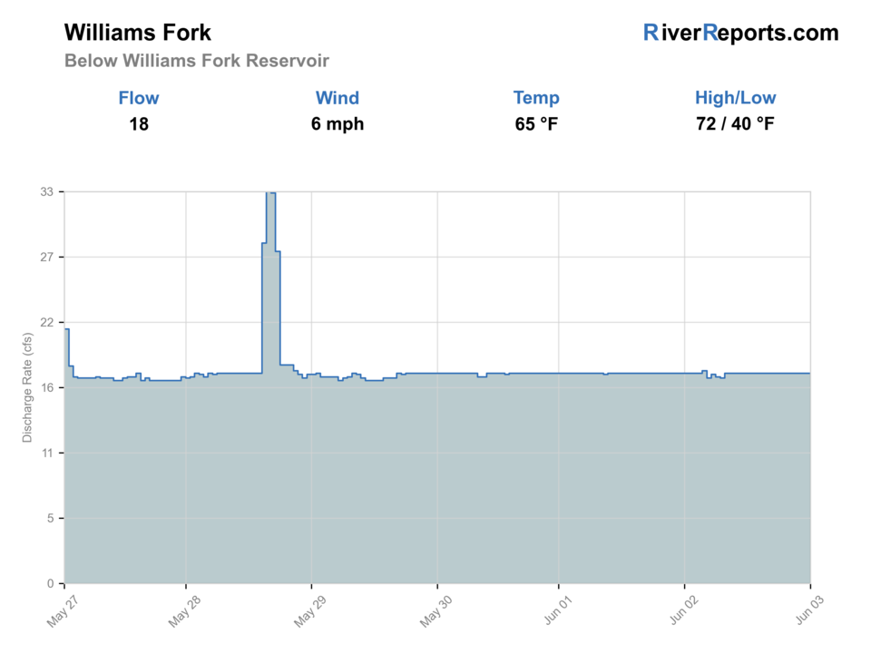
USGS data chart
Official USGS trend
Streamflow over the latest USGS reporting window.
Latest
18 cfs
Jun 3, 4 PM UTC
Weather
River weather report
Weather can change wading safety, road access, water temperature, hatches, and the best time of day to fish.
Live forecast loads as you reach this section
This keeps the report fast while still using the official National Weather Service forecast point.
Hatches and flies
Hatch chart and fly picks
Spring
Midges, BWOs, and caddis
RS2, zebra midge, BWO emerger, caddis pupa
Summer
PMDs, caddis, yellow sallies, and terrestrials
PMD dry, elk hair caddis, yellow stimulator, ant
Late summer
Terrestrials and evening caddis
Beetle, hopper-dropper, caddis soft hackle
Fall
BWOs and midges
Parachute BWO, RS2, zebra midge
Tailwater nymphs
RS2, zebra midge, pheasant tail, perdigon, caddis pupa
Use through seams and runs when the fish are not obviously on dries.
Dry flies
PMD, caddis, parachute Adams, beetle
Best when fish rise in gentler bankside water or during evening bug windows.
Weight and color
Small stonefly nymph, hares ear, mini bugger
Useful only when releases are still safe enough to fish from the edge effectively.
Tactics
How to fish it
Build the day around the lower-river access pieces first, then decide whether a reservoir-side stop adds anything useful.
Fish the first deep soft seam well because legal lower-river access is better used carefully than covered quickly.
Do not let the broader Williams Fork name trick you into mixing lower tailwater tactics with upper-trail creek expectations.
If the river is too high or the corridor is crowded, the Colorado River is the more forgiving nearby backup.
Rigging
Rod, leader, and setup notes
A 4- or 5-weight floating-line setup is the best default for the lower river.
Carry 5X and 6X tippet for small nymphs and technical clear-water drifts.
A compact two-fly nymph rig is usually more practical than a heavy long setup.
Pack sun and wind layers because the lower valley can feel much more exposed than the map suggests.
Access
Access and planning notes
Kemp-Breeze SWA
Primary lower-river accessWade / float / trail
SWA / wade / bank
When to pick it
Start here when the below-reservoir flow and current SWA rules support a focused wade session.
Caution
Confirm the SWA map, signs, and exact public boundaries.
Williams Fork Reservoir
Reservoir and release contextWade / float / trail
Reservoir / bank / release check
When to pick it
Use it when reservoir operations or a stillwater backup affect the day.
Caution
Reservoir rules and lower-river rules are separate decisions.
Williams Fork Trailhead
Upper drainage contextWade / float / trail
Trail / upper-valley scout
When to pick it
Pick it when an upper-valley plan makes more sense than lower release-driven water.
Caution
Trail access does not describe lower-river public boundaries.
Kemp-Breeze SWA is the strongest lower-river public-access source and includes no-public-access areas that matter on the ground.
Denver Water reservoir rules are separate from lower-river fishing decisions and can change with water levels and parking controls.
The upper-valley trailhead is useful context, but the lower river toward Parshall is the better-scoped fishery for this page.
Regulations
Check before fishing
Check the current Colorado fishing brochure before fishing and confirm any SWA entry requirements. Use current CPW and site-specific public-land pages rather than older forum advice or recycled reservoir summaries.
Primary base
Parshall, Kremmling, or Granby
Best day style
State wildlife area entries, reservoir day-use nodes, and short wade sessions
Check first
RiverReports, USGS 09038500, Colorado rules, SWA boundaries, reservoir access status, and weather
Safety
Cold release water, slick banks, wind, private-boundary mistakes, and changing reservoir-side conditions
Gear
Helpful gear for this water
4- or 5-weight rod
A flexible fit for small nymphs, caddis, and technical lower-river drifts.
Fine tippet
5X and 6X are useful when the lower tailwater runs clear.
Wind layer
The valley and reservoir corridor can get gusty fast.
Map or offline screenshot
Helpful for SWA boundaries and reservoir versus river access distinctions.
Nearby water
Other water to research
Backup logic
High water
Compare the Colorado River or wait for controlled releases to settle before wading the lower Williams Fork.
Heat
Fish early and keep trout handling short, especially in shallow edges or low releases.
Storms or wind
Delay when wind or storms make the exposed lower valley difficult to fish safely.
Access issue
Use SWA, Denver Water, or Forest Service-confirmed access only; pivot if lower-river boundaries are unclear.
Colorado River
A broader nearby option when the Williams Fork corridor feels too limited or release-driven.
Blue River
A Summit/Frisco-area technical backup if you are moving east.
Troublesome Creek
A smaller local alternate if you are looking for a different lower-valley feel.
FAQ
Fast answers
Is Williams Fork fishable today?
Williams Fork looks very fishable right now. The live score is 96/100, based on current flow, weather, public alerts, and the report's planning context. Recheck the linked gauge and forecast before leaving because conditions can change quickly after rain, heat, access changes, or flow swings.
What flow is best for Williams Fork?
Stable controlled releases that leave visible seams and safe edge water without turning the whole corridor into pushy bank water.
When should I skip Williams Fork?
Skip when releases are too high for comfortable edge fishing, when the valley wind is punishing, or when access is more constrained than expected.
Is Williams Fork safe to wade right now?
The fishability score is not a wading guarantee. Wade only where your chosen access has safe edges, clear footing, legal entry, and no forced crossings; high, rising, stained, or storm-affected water should be treated conservatively.
What part of the Williams Fork does this page cover?
It is centered on the lower river below Williams Fork Reservoir toward Parshall, not the reservoir shoreline or upper trail water.
What gauge should I use?
Use RiverReports and USGS 09038500 because that station sits just below the reservoir and matches the lower-river plan.
Is the upper valley the same fishery?
No. The upper trail corridor, reservoir access, and lower tailwater each need to be planned separately.
Sources
Source set for this report
Reviewed 2026-05-31