
Colorado / West
San Miguel River
A southwest Colorado San Miguel report for Telluride, Placerville, Norwood, and canyon water, with flow checks, access notes, hatches, flies, and safety guidance.
Image: San Miguel River near Nucla Colorado.. / CC BY-SA 3.0 / PGHolbrookFishability now: San Miguel River fishability today
GreatData confidence: High96/100
Fishable now because the live gauge is stable, weather is mild, and no public alert is active.
Flow observed
5:05 PM UTC
Weather observed
5:00 PM UTC
Score calculated
5:25 PM UTC
Why this rating
Flow
Weather
Public alerts
Next 6-12 hours
Hold
Stable live data supports staying with the plan, but recheck the gauge and forecast before leaving.
USGS flow
262 cfs
Current trend: flow stable, so weather, temperature, and access checks drive the next change.
More planning details: flies, flow bands, and live source checks
Fish it today
Start here
Pick the reach before you pick the flies: upper or mid-river public access if you want trout-focused wading, or a separate lower-canyon objective only when flow, access, and exit logistics are all settled ahead of time.
Best flow clue
Use the Placerville trend as the common planning anchor. Stable or slowly easing summer flow is the best fit for upper-river trout tactics; runoff surges, storm color, or hot low water should move you to cooler headwater choices or another drainage.
Skip trigger
Skip the trip when runoff or wood hazards turn the river reactive, when lower-river heat threatens trout handling, when access around private ground is unclear, or when you really need a simpler tailwater day instead of a reach-management problem.
Flow decision bands
Low but fishable
Low clear San Miguel water can fish along edges, pocket water, and shaded bends when temperatures stay responsible.
Best freestone window
Stable or slowly falling Placerville flow with clear water gives the best dry-dropper, nymph, and light-streamer signal.
Runoff or woody water
High, fast, stained, or debris-loaded water should stop crossings and tight canyon wading.
Lower-canyon heat caution
Hot afternoons and low water can shift the plan toward early sessions or a different trout stream.
USGS flow
262 cfs
Current trend: flow stable, so weather, temperature, and access checks drive the next change.
Live USGS flow
262 cfs / stable
Live NWS forecast
53F / Mostly Sunny
Water temperature not verified
Heat guidance uses weather and river type unless an official water-temperature value is available.
No NWS alert flag
No active NWS alert was returned for this forecast point.
RiverReports and USGS 09172500 are the core flow checks for the Placerville reach.
Upper river trout tactics differ from lower Norwood and Nucla-area canyon planning.
BLM access sites such as Caddis Flats and Lower Beaver help with lower-river logistics.
Snowmelt and wood hazards can change safe wading and floating decisions quickly.
Editorial review
How this report is maintained
This San Miguel River report is maintained from current Colorado regulation, BLM access, county-trail, flow, and weather checks so anglers can separate upper trout water from lower canyon travel without inventing local certainty.
Byline
BlueStreamFly editorial team
Reviewed by
BlueStreamFly source review
Maintained by
Mountain Brook Run LLC
Last material review
2026-05-31
Report confidence
Good confidence
88/100
Good confidence: RiverReports, USGS 09172500 flow, BLM Caddis Flats and Lower Beaver access sources, San Miguel County context, Colorado regulation sources, and weather data support the page. Confidence is moderated by private frontage, broad corridor scope, canyon hazards, summer heat, runoff, and wood.
Regulations
Colorado regulation sources support the legal-check path before fishing San Miguel water.
Access
BLM Caddis Flats and Lower Beaver sources support strong public access planning, with exact banks, parking, and private edges still needing current confirmation.
Flow and weather
RiverReports, USGS 09172500, and the National Weather Service point are attached to the route.
Fishing usefulness
The page now separates BLM access, Placerville trend checks, upper-versus-lower reach choice, runoff, heat, wood hazards, and backup waters.
Fishability dashboard and source review
2026-05-31 / material content or source review
RiverReports San Miguel chart, USGS 09172500 flow data, BLM Caddis Flats and Lower Beaver recreation sources, San Miguel County trail/access context, Colorado regulation sources, and the National Weather Service point were checked before updating the current fishability guidance.
2026-05-31
Updated San Miguel River with Placerville trend guidance, BLM access cards, private-frontage and canyon cautions, backup cues, stable fishability SEO, and confidence signals.
2026-05-28
Added upper-versus-lower river trip-fit guidance, wade-versus-float framing, runoff and warm-water skip cues, access nuance, pressure timing, backup-water suggestions, and a page-specific report-confidence meter after source review.
2026-05-24
Initial source-reviewed report published with flows, weather, hatches, flies, tactics, access, regulations, and FAQs.
Angler planning edge
Local details that change the plan
Best for
Anglers who need one page to separate Telluride and Placerville trout water from lower canyon travel decisions, Trips where runoff trend, wood hazard, and private-land boundaries matter as much as hatch timing, Mixed dry-dropper, nymph, and small-streamer days once the river clears and cools enough for trout handling, Travel plans with a backup ready if heat, high water, or canyon logistics make the main plan too shaky
Wade or float
Treat the San Miguel as a mixed wade-or-float page with a strong reach-choice warning. Upper and middle sections are the cleaner fit for wade planning, while lower canyon water demands more careful logistics and should not be treated as a casual fallback.
Best flows
Use the Placerville trend as the common planning anchor. Stable or slowly easing summer flow is the best fit for upper-river trout tactics; runoff surges, storm color, or hot low water should move you to cooler headwater choices or another drainage.
When to skip
Skip the trip when runoff or wood hazards turn the river reactive, when lower-river heat threatens trout handling, when access around private ground is unclear, or when you really need a simpler tailwater day instead of a reach-management problem.
Local plan
Pick the reach before you pick the flies: upper or mid-river public access if you want trout-focused wading, or a separate lower-canyon objective only when flow, access, and exit logistics are all settled ahead of time.
Pressure
The San Miguel rarely feels like an urban crowd problem, but pressure still compresses around the most visible public stops near Placerville and BLM sites. An early start and a willingness to fish one chosen section carefully usually improve the day.
Access nuance
The river mixes BLM sites, county-trail context, and private land. Public access exists, but it is not continuous, and lower canyon miles should not be treated like one open trout corridor just because a few named sites are public.
Backup water
If the San Miguel is too pushy, warm, or access-sensitive, pivot to the Dolores for a release-driven southwest Colorado option or to the Taylor River for a more controlled tailwater day.
About the river
Setting, character, and why it fishes the way it does.
The San Miguel begins in the San Juan Mountains near Telluride and drops toward Placerville, Norwood, and the Dolores River basin.
It is one of Colorado's more natural-flowing southwest rivers, which means snowmelt, rain, and summer heat strongly affect fishing conditions.
Upper reaches are more trout-oriented, while lower reaches include canyon access, boating logistics, and warmer-water species context.
This page avoids treating the entire river as one identical trout stream. The safest plan is reach-specific.
Target species
Brown trout
A key trout target in upper and mid-river structure when water is cool and fishable.
Rainbow trout
Possible in trout-oriented reaches; nymphs, caddis, and mayflies are useful when flows settle.
Cutthroat trout
Relevant in connected high-country and tributary context, but verify exact reach expectations.
Warmwater and nonnative species
Lower river regulations include special harvest language for some warmwater or nonnative species.
Reading the water
Runoff
Snowmelt can make the river powerful, cold, and unsafe for casual wading.
Stable summer flow
Fish riffles, banks, and pocket water with caddis, mayflies, terrestrials, and light nymphs.
Low warm water
Carry a thermometer and stop targeting trout if water temperatures create handling risk.
Storm bump
Watch for debris, stain, and wood. Avoid blind crossings and lower-canyon hazards.
Best seasons
Spring
Pre-runoff can fish well, but the snowmelt rise can quickly make the river unsafe or off-color.
Summer
Post-runoff caddis, mayflies, yellow sallies, and terrestrials can be useful in cool water.
Fall
Cooler weather, lower flows, and streamer windows can improve upper and mid-river trout fishing.
Winter
Cold weather, ice, and mountain access can make fishing limited and local.
Preferred flow source
San Miguel River near Placerville
RiverReports is the preferred chart source when coverage exists. When a matching USGS gauge exists, keep it open as the official backstop for station data and current hydrograph context.
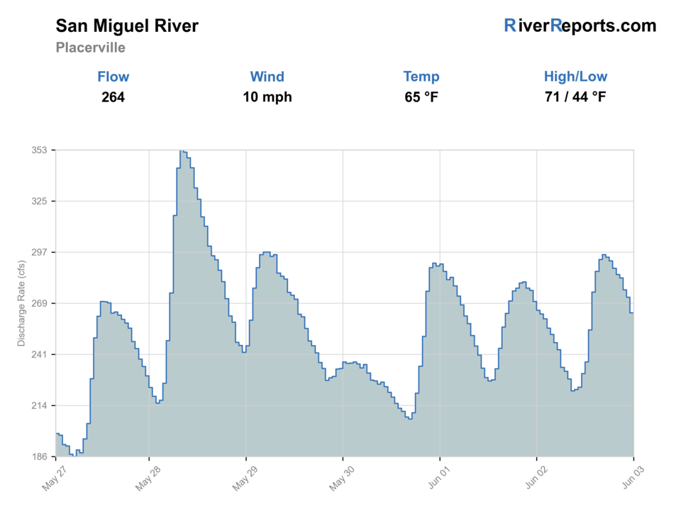
USGS data chart
Official USGS trend
Streamflow over the latest USGS reporting window.
Latest
262 cfs
Jun 3, 5 PM UTC
Weather
River weather report
Weather can change wading safety, road access, water temperature, hatches, and the best time of day to fish.
Live forecast loads as you reach this section
This keeps the report fast while still using the official National Weather Service forecast point.
Hatches and flies
Hatch chart and fly picks
Spring
Midges, BWOs, stoneflies
Zebra midge, BWO emerger, Pat's rubber legs, pheasant tail
Early summer
Caddis, PMDs, yellow sallies
Elk hair caddis, PMD, yellow sally, hare's ear
Late summer
Terrestrials, caddis, small mayflies
Foam ant, beetle, hopper, caddis, parachute Adams
Fall
BWOs, midges, baitfish and sculpin activity
BWO dry, zebra midge, soft hackle, leech, sculpin
Nymphs
Pheasant tail, hare's ear, perdigon, caddis pupa, stonefly nymph
Use in pocket water, riffles, and deeper bends when no hatch is obvious.
Dry flies
Caddis, PMD, BWO, parachute Adams, yellow sally
Use when flows clear and fish feed in riffles or soft edges.
Terrestrials
Ant, beetle, hopper, small chubby
Use near grassy banks and undercut edges in late summer.
Streamers
Sculpin, leech, bugger, sparkle minnow
Use during low light, fall, or slightly stained conditions.
Tactics
How to fish it
Choose upper trout water or lower canyon water before picking tactics.
Use the Placerville gauge as the core flow read, then match it to your reach.
Avoid fishing behind private homes or ranches unless access is clearly public.
Watch for wood, strainers, and narrow channel hazards after runoff.
Use shade, early starts, and a thermometer during hot low-water periods.
Rigging
Rod, leader, and setup notes
A 9-foot 4-weight or 5-weight fits most trout fishing.
Carry a 6-weight if streamers or windy lower-canyon water are part of the day.
Use 4X to 6X depending on clarity and fly size.
Bring a compact dry-dropper and nymph kit for quick depth changes.
Carry water, sun gear, and a map for lower canyon access.
Access
Access and planning notes
Caddis Flats
BLM public access anchorWade / float / trail
BLM / bank / wade
When to pick it
Start here when the flow is settled and a signed public bank is the safest plan.
Caution
Use posted public access and do not assume nearby private frontage is open.
Lower Beaver Recreation Site
Lower river and canyon contextWade / float / trail
BLM / bank / scout
When to pick it
Use it when lower-corridor access and road logistics fit the day.
Caution
Heat, canyon footing, and changing water can make the lower reach less forgiving.
Telluride / Placerville corridor
Reach choice and trail contextWade / float / trail
Road / trail / wade scout
When to pick it
Pick it when deciding whether upper, middle, or lower water is the better match.
Caution
County-trail context does not make every riverbank public.
San Miguel County trail information helps with upper-corridor public recreation planning.
BLM Caddis Flats and Lower Beaver pages document lower-river recreation access.
Private property and legal bank access are important throughout the drainage.
Older hazard notices should be treated as safety context, not current closure proof without a current source.
Regulations
Check before fishing
Verify current Colorado statewide and special regulations for the exact reach. Lower-river warmwater harvest language does not replace trout rules upstream.
Primary base
Telluride, Placerville, or Norwood, Colorado
Best day style
Roadside upper river, BLM lower sites, and private-land boundaries
Check first
Placerville flow, public access, runoff, wood hazards, rules, and weather
Safety
Snowmelt, strainers, private property, remote canyon exits, and summer heat
Gear
Helpful gear for this water
Thermometer
Essential during low summer water and lower-river trout decisions.
Dry-dropper box
Caddis, mayflies, yellow sallies, and terrestrials cover many windows.
Map and access notes
Public access and private property are central to the day.
Sun and storm gear
Southwest Colorado weather can shift from bright heat to storms quickly.
Nearby water
Other water to research
Backup logic
High water
Wait for the San Miguel to fall or compare the Dolores, Uncompahgre, or upper Gunnison options.
Heat
Fish early, move higher, or stop trout pressure when lower canyon water warms.
Storms or stain
Let monsoon color, wood, and road conditions settle before entering tight banks.
Access issue
Use BLM-listed or clearly signed public access only; pivot if private frontage or parking is uncertain.
Dolores River
A release-dependent southwest Colorado tailwater and canyon river.
Animas River
A Durango-area river with more town access and a verified gauge.
Cimarron River
A high-country Gunnison basin option near Silver Jack Reservoir.
FAQ
Fast answers
Is San Miguel River fishable today?
San Miguel River looks very fishable right now. The live score is 96/100, based on current flow, weather, public alerts, and the report's planning context. Recheck the linked gauge and forecast before leaving because conditions can change quickly after rain, heat, access changes, or flow swings.
What flow is best for San Miguel River?
Use the Placerville trend as the common planning anchor. Stable or slowly easing summer flow is the best fit for upper-river trout tactics; runoff surges, storm color, or hot low water should move you to cooler headwater choices or another drainage.
When should I skip San Miguel River?
Skip the trip when runoff or wood hazards turn the river reactive, when lower-river heat threatens trout handling, when access around private ground is unclear, or when you really need a simpler tailwater day instead of a reach-management problem.
Is San Miguel River safe to wade right now?
The fishability score is not a wading guarantee. Wade only where your chosen access has safe edges, clear footing, legal entry, and no forced crossings; high, rising, stained, or storm-affected water should be treated conservatively.
What part of the San Miguel does this report cover?
It covers the upper Telluride and Placerville trout plan plus lower BLM canyon access context.
What gauge should I check?
Use RiverReports and USGS 09172500 near Placerville as the primary flow reference.
Is the whole San Miguel trout water?
No. Upper and mid-river reaches are more trout-focused, while lower reaches include warmer-water and different regulation context.
What flies should I bring?
Bring midges, BWOs, caddis, PMDs, yellow sallies, terrestrials, nymphs, and a few streamers.
Sources
Source set for this report
Reviewed 2026-05-31