
Colorado / West
Piedra River
A Piedra River report for anglers comparing lower Arboles flow context with upper San Juan National Forest access and remote canyon logistics.
Image: Generated regional planning image for Piedra River / BlueStreamFly generated; not exact location / BlueStreamFlyFishability now: Piedra River fishability today
GreatData confidence: High96/100
Fishable now because the live gauge is stable, weather is usable, and no public alert is active.
Flow observed
3:15 PM UTC
Weather observed
4:00 PM UTC
Score calculated
4:20 PM UTC
Why this rating
Flow
Weather
Public alerts
Next 6-12 hours
Hold
Stable live data supports staying with the plan, but recheck the gauge and forecast before leaving.
USGS flow
170 cfs
Current trend: flow stable, so weather, temperature, and access checks drive the next change.
More planning details: flies, flow bands, and live source checks
Fish it today
Start here
Use Pagosa or Bayfield as a base, verify access and roads, check the RiverReports trend, then fish a short confirmed public section.
Best flow clue
Clear, stable post-runoff flows with safe edges and cool water.
Skip trigger
Skip during peak runoff, storm color, hot low-water afternoons, or when road/access status is uncertain.
Flow decision bands
Low but fishable
Low clear Piedra water can fish in bends, banks, and canyon structure when temperatures and access are safe.
Best remote trout window
Stable or falling Arboles flow with clear water and mild weather is the best dry-dropper, nymph, and streamer signal.
Runoff or storm unsafe
Runoff, muddy monsoon pulses, or uncertain roads should stop remote wading plans.
Boundary caution
Private and tribal-boundary context can matter as much as the flow graph.
USGS flow
170 cfs
Current trend: flow stable, so weather, temperature, and access checks drive the next change.
Live USGS flow
170 cfs / stable
Live NWS forecast
74F / Mostly Sunny
Water temperature not verified
Heat guidance uses weather and river type unless an official water-temperature value is available.
No NWS alert flag
No active NWS alert was returned for this forecast point.
RiverReports gives the working flow chart for the lower Piedra near Arboles.
San Juan National Forest sources confirm stream fishing opportunities and Piedra-area trail/water access, but roads and trailheads need current checks.
Private, tribal, and reservoir-adjacent lands make boundary awareness important below the forest corridor.
Small nymphs, attractor dries, and light streamers are the useful fly-fishing base when water is clear and safe.
Editorial review
How this report is maintained
This report uses official regulation, flow, weather, access, and public-land sources first, then adds practical planning guidance for fly anglers.
Byline
BlueStreamFly editorial desk
Reviewed by
BlueStreamFly source review
Maintained by
BlueStreamFly
Last material review
2026-05-31
Report confidence
Good confidence
86/100
Good confidence: RiverReports Arboles chart, USGS 09349800 flow, San Juan National Forest fishing and Piedra route context, Colorado regulation sources, and weather data support the page. Confidence is moderated by lower-gauge representation, private and tribal boundaries, remote roads, storms, and warm low water.
Regulations
Colorado regulation sources support the legal-check path before choosing Piedra River water.
Access
San Juan National Forest sources support public-land planning, but exact fishing access, private edges, and tribal-boundary context need current confirmation.
Flow and weather
RiverReports, USGS 09349800, and the National Weather Service point are attached to the route.
Fishing usefulness
The page now separates Arboles flow, public-land access, hot springs route context, boundaries, runoff, storms, heat, and backup choices.
Fishability dashboard and source review
2026-05-31 / material content or source review
RiverReports Piedra River near Arboles chart, USGS 09349800 flow data, San Juan National Forest river fishing and Piedra River Hot Springs access context, Colorado regulation sources, and the National Weather Service point were checked before updating the current fishability guidance.
2026-05-31
Updated Piedra River with Arboles trend guidance, remote public-access cards, private and tribal-boundary cautions, runoff and warm-water backup cues, stable fishability SEO, and confidence signals.
2026-05-29
Added a page-specific report-confidence meter and added USGS Piedra River near Arboles as official flow context for remote Piedra River planning.
2026-05-25
Published a new Piedra River report with lower-flow context, access cautions, hatch guidance, and remote-trip planning.
Angler planning edge
Local details that change the plan
Best for
Remote southwest Colorado trout planning, Fall dry-dropper days, Anglers comfortable checking access first
Wade or float
Wade-focused. Floating is not the default plan for this report and should not replace access/legal checks.
Best flows
Clear, stable post-runoff flows with safe edges and cool water.
When to skip
Skip during peak runoff, storm color, hot low-water afternoons, or when road/access status is uncertain.
Local plan
Use Pagosa or Bayfield as a base, verify access and roads, check the RiverReports trend, then fish a short confirmed public section.
Pressure
Pressure is lower than town water but concentrates near obvious trailheads and hot-springs routes.
Access nuance
The chart is lower-river context. Your actual fishing plan depends on public-land, private-land, and tribal-boundary checks.
Backup water
San Juan at Pagosa Springs is the easiest backup when the Piedra access plan is too uncertain.
About the river
Setting, character, and why it fishes the way it does.
The Piedra River drains southwest Colorado toward Navajo Reservoir, moving through forested and canyon country before lower valley water.
For fly anglers, the upper and middle public-access pieces require more planning than a town river but can offer quiet trout water when flows and roads cooperate.
The lower RiverReports site helps with trend context, but it should not be mistaken for a complete access plan for every mile of river.
Target species
Brown trout
A core trout target in deeper bends, undercut banks, and canyon structure.
Rainbow trout
Possible in mixed trout water and faster runs.
Native trout context
Handle all trout quickly, especially in warmer lower-season water.
Reading the water
Clear moderate flow
Best mix for dry-dropper rigs, pocket water, and light nymphing.
Low summer water
Fish early, use small flies, and stop if water feels too warm.
High snowmelt
Avoid remote wading and wait for safer visibility and softer edges.
Storm color
Canyon and road conditions can change quickly; use a safer backup.
Best seasons
Spring
Useful before or after peak runoff, not during unsafe snowmelt push.
Summer
Best early and high in the system; lower warm-water stress can become a concern.
Fall
Often the best all-around window for lower flows, cooler nights, and lighter pressure.
Winter
Access, ice, and road conditions limit the practical plan.
Preferred flow source
Piedra River near Arboles
RiverReports is the preferred chart source when coverage exists. When a matching USGS gauge exists, keep it open as the official backstop for station data and current hydrograph context.
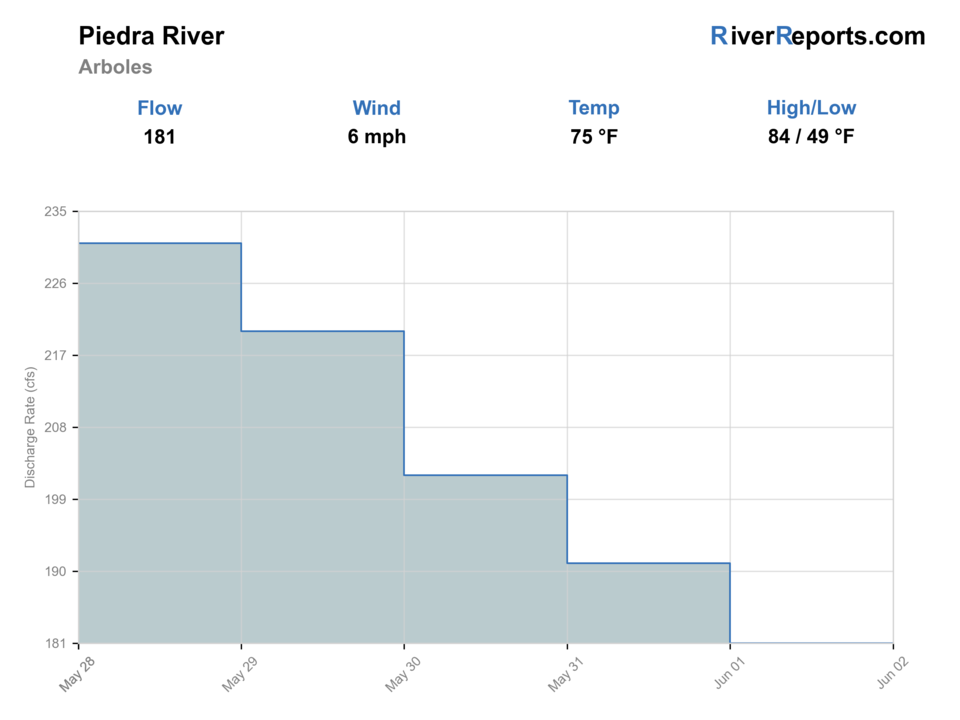
USGS data chart
Official USGS trend
Streamflow over the latest USGS reporting window.
Latest
170 cfs
Jun 3, 4 PM UTC
Weather
River weather report
Weather can change wading safety, road access, water temperature, hatches, and the best time of day to fish.
Live forecast loads as you reach this section
This keeps the report fast while still using the official National Weather Service forecast point.
Hatches and flies
Hatch chart and fly picks
Spring
Midges, BWOs, small stones
RS2, zebra midge, pheasant tail, small stonefly nymph
Summer
Caddis, PMDs, yellow sallies, terrestrials
Elk hair caddis, parachute PMD, yellow stimulator, foam ant
Late summer
Terrestrials and evening caddis
Hopper, beetle, caddis pupa, soft hackle
Fall
BWOs, midges, small baitfish
BWO emerger, zebra midge, olive bugger
Attractor dries
Stimulator, chubby, elk hair caddis, parachute Adams
Use in clear pocket water and shaded runs.
Nymphs
Pheasant tail, perdigon, hare's ear, zebra midge
Use below a dry or short indicator when fish are deeper.
Light streamers
Olive bugger, mini sculpin, leech
Use on cloudy days, deeper bends, or fall windows.
Tactics
How to fish it
Pick the access first, then choose the fishing style. Do not build the day around unverified banks.
Fish shade, canyon pocket water, and deeper bends before stepping into visible lanes.
Carry enough water and a simple exit plan because some public pieces feel remote quickly.
During low warm water, fish early and stop before trout handling becomes risky.
Rigging
Rod, leader, and setup notes
A 4- or 5-weight floating-line setup covers most trout water.
Carry 4X to 6X tippet for dry-dropper and nymph adjustments.
Use compact rigs because brush, rock, and canyon banks can make long leaders hard to manage.
Footwear and traction matter more than distance; choose safe entry and exit points.
Access
Access and planning notes
San Juan National Forest fishing context
Public-land planningWade / float / trail
Forest access / wade / scout
When to pick it
Start here when the day depends on confirmed public-land access.
Caution
Forest context is broad and does not make every bank public.
Piedra River Hot Springs route
Trail and road orientationWade / float / trail
Trail / remote scout / bank
When to pick it
Use it when road and route status are central to the plan.
Caution
Recreation access and fishing access still need exact confirmation.
Arboles gauge context
Lower-river flow checkWade / float / trail
Gauge / trip decision
When to pick it
Pick it before deciding whether the river is too high, warm, or stained.
Caution
The lower gauge may not describe every upper public reach.
Confirm roads, trailheads, and forest restrictions before committing to a remote Piedra plan.
Do not assume lower valley banks are public. Private, tribal, and reservoir-adjacent land can change the legal plan.
Carry water, layers, and a navigation plan; cell coverage can be inconsistent.
Regulations
Check before fishing
Use the current Colorado fishing brochure before fishing and confirm whether your chosen access is on public land, private land, tribal land, or a managed recreation site.
Primary base
Pagosa Springs, Bayfield, or Arboles
Best day style
Forest trail access, remote canyon planning, and strict boundary checks
Check first
RiverReports, Colorado regulations, San Juan National Forest access, road status, and weather
Safety
Remote access, warm lower water, canyon exits, storms, private boundaries, and limited service
Gear
Helpful gear for this water
4- or 5-weight rod
Covers dries, nymphs, and small streamers.
Navigation backup
Useful for forest roads, trailheads, and canyon exits.
Warm-weather trout care
Thermometer, forceps, and quick-release habits matter in summer.
Extra water
Remote public access can be hot and exposed.
Nearby water
Other water to research
Backup logic
High water
Compare the San Juan at Pagosa Springs or wait for the Arboles trend to fall.
Heat
Fish early or move to colder higher water; stop trout pressure in warm low water.
Storms or stain
Delay until monsoon color, road access, and lightning risk settle.
Access issue
Use confirmed public access only; pivot to the San Juan if private or tribal boundaries are unclear.
San Juan at Pagosa Springs
A more town-based plan with public river-use information.
Animas River
A larger San Juan Mountains trout option with clearer corridor planning.
Dolores River
Another southwest Colorado report when you need a different basin.
FAQ
Fast answers
Is Piedra River fishable today?
Piedra River looks very fishable right now. The live score is 96/100, based on current flow, weather, public alerts, and the report's planning context. Recheck the linked gauge and forecast before leaving because conditions can change quickly after rain, heat, access changes, or flow swings.
What flow is best for Piedra River?
Clear, stable post-runoff flows with safe edges and cool water.
When should I skip Piedra River?
Skip during peak runoff, storm color, hot low-water afternoons, or when road/access status is uncertain.
Is Piedra River safe to wade right now?
The fishability score is not a wading guarantee. Wade only where your chosen access has safe edges, clear footing, legal entry, and no forced crossings; high, rising, stained, or storm-affected water should be treated conservatively.
Is the Piedra an easy roadside river?
No. Some areas require forest-road, trail, or canyon planning, and access must be confirmed.
What flow should I look for?
Look for clear, stable flows with safe edge water. Avoid peak runoff and storm-color days.
Can I rely only on the Arboles chart?
No. Use it for trend context, then verify your actual access point and local weather.
Sources
Source set for this report
Reviewed 2026-05-31