
Colorado / West
Gunnison Gorge of the Black Canyon
A source-checked Gunnison Gorge report for Black Canyon and Gunnison Gorge planning, with flows, access difficulty, hatches, flies, and safety notes.
Image: South Rim, Black Canyon of the Gunnison National Park, Colorado (66825800) / CC BY-SA 2.0 / Ken Lund from Reno, Nevada, USAFishability now: Gunnison Gorge of the Black Canyon fishability today
GreatData confidence: High96/100
Fishable now because the live gauge is falling, weather is usable, and no public alert is active.
Flow observed
4:45 PM UTC
Weather observed
4:00 PM UTC
Score calculated
5:10 PM UTC
Why this rating
Flow
Weather
Public alerts
Next 6-12 hours
Improving / hold
A falling gauge and usable weather should keep the next 6-12 hours in play unless tributaries stain or heat builds.
USGS flow
300 cfs
Current trend: flow falling, rating likely holding strong unless weather or clarity changes.
More planning details: flies, flow bands, and live source checks
Fish it today
Start here
Choose the access style first: East Portal and park context for a shorter controlled plan, or BLM Gunnison Gorge routes only when the group is ready for steep travel, limited shade, and a full exit commitment.
Best flow clue
Use the RiverReports Gunnison Tunnel chart and USGS 09128000 together. Stable releases are the cleanest planning signal; sudden changes, high pushy water, or flows that erase safe edge water should move you to a different reach or a different day.
Skip trigger
Skip the Gorge when you are not prepared for the hike or float logistics, when heat or thunderstorms raise canyon risk, when NPS or BLM rules are unclear for the exact water you plan to fish, or when release changes make safe wading unrealistic.
Flow decision bands
Low but fishable
Lower stable releases can fish well from legal canyon edges when access route, exit timing, and temperatures are safe.
Best canyon window
Stable Gunnison Tunnel flow with mild weather and clear access logistics is the strongest nymph, streamer, caddis, and terrestrial signal.
Pushy or unsafe
Higher releases, sudden changes, thunderstorms, or heat should stop casual wading and make float or canyon plans more conservative.
Logistics override
A fishable graph is not enough if permits, route choice, self-rescue, shade, or exit timing are not settled.
USGS flow
300 cfs
Current trend: flow falling, rating likely holding strong unless weather or clarity changes.
Live USGS flow
300 cfs / falling about 13%
Live NWS forecast
79F / Sunny
Water temperature not verified
Heat guidance uses weather and river type unless an official water-temperature value is available.
No NWS alert flag
No active NWS alert was returned for this forecast point.
Use RiverReports and USGS 09128000 for the below-Gunnison-Tunnel flow read.
NPS identifies the Black Canyon Gunnison River as Gold Medal and Wild Trout Water with special rules.
BLM Gunnison Gorge Wilderness routes require more planning than a roadside trout stop.
Carry water, layers, emergency gear, and a clear exit plan before committing to inner-canyon access.
Editorial review
How this report is maintained
This Gunnison Gorge report is maintained from RiverReports and USGS flow data, National Park Service fishing rules, BLM access sources, weather checks, and practical canyon-planning guidance. Review dates change only after material source review or content improvements.
Byline
BlueStreamFly editorial team
Reviewed by
BlueStreamFly source review
Maintained by
Mountain Brook Run LLC
Last material review
2026-05-31
Report confidence
Good confidence
89/100
Good confidence: RiverReports Gunnison Tunnel chart, USGS 09128000 flow, NPS Black Canyon fishing information, BLM Gunnison Gorge NCA and Wilderness sources, and weather data support the page. Confidence is moderated by remote canyon logistics, permits, steep access, heat, thunderstorms, and release changes.
Regulations
NPS Black Canyon fishing information supports the legal-check path for the park reach, with BLM context needed for Gorge access.
Access
NPS and BLM sources give strong public-access anchors, but permits, route choice, road status, and exit timing still need current confirmation.
Flow and weather
RiverReports, USGS 09128000, and the National Weather Service point are attached to the route.
Fishing usefulness
The page now separates East Portal, Gorge, and wilderness planning, release stability, canyon heat, storm risk, permits, and backup choices.
Fishability dashboard and source review
2026-05-31 / material content or source review
RiverReports Gunnison River below Gunnison Tunnel chart, USGS 09128000 flow data, NPS Black Canyon fishing information, BLM Gunnison Gorge NCA and Wilderness access sources, and the National Weather Service point were checked before updating the current fishability guidance.
2026-05-31
Updated Gunnison Gorge of the Black Canyon with Gunnison Tunnel release guidance, East Portal and Gorge access cards, canyon heat and storm cautions, backup cues, stable fishability SEO, and confidence signals.
2026-05-28
Added remote-canyon trip-fit guidance, wade-versus-float framing, release and weather skip cues, wilderness access nuance, pressure timing, backup-water suggestions, editorial review signals, and a page-specific report-confidence meter after source review.
2026-05-24
Initial source-reviewed report published with flows, weather, hatches, flies, tactics, access, regulations, and FAQs.
Angler planning edge
Local details that change the plan
Best for
Experienced anglers planning a remote Black Canyon or Gunnison Gorge trout day, Trips where flow, route choice, heat, and exit timing matter as much as fly selection, Nymph, streamer, caddis, BWO, and terrestrial windows when releases and weather line up, Anglers deciding between a serious canyon plan, East Portal context, or easier Gunnison basin water
Wade or float
Treat this as a serious canyon page, not a casual roadside wade. Wade plans need a specific legal access route and a realistic exit plan; float plans need separate launch, takeout, boat, weather, and self-rescue checks.
Best flows
Use the RiverReports Gunnison Tunnel chart and USGS 09128000 together. Stable releases are the cleanest planning signal; sudden changes, high pushy water, or flows that erase safe edge water should move you to a different reach or a different day.
When to skip
Skip the Gorge when you are not prepared for the hike or float logistics, when heat or thunderstorms raise canyon risk, when NPS or BLM rules are unclear for the exact water you plan to fish, or when release changes make safe wading unrealistic.
Local plan
Choose the access style first: East Portal and park context for a shorter controlled plan, or BLM Gunnison Gorge routes only when the group is ready for steep travel, limited shade, and a full exit commitment.
Pressure
The canyon filters out casual traffic, but the most practical access points, camps, and boat logistics can still concentrate anglers. A realistic early start and a single focused route beat trying to sample too many canyon options.
Access nuance
BLM and NPS sources support the public framework, but this is remote water with hard terrain. Public access on a map does not remove the need for route finding, permits or use rules where required, water, weather judgment, and emergency planning.
Backup water
If the Gorge is too hot, too high, too stormy, or too logistically heavy, compare the Lower Gunnison for easier valley context, the Upper Gunnison for a different basin plan, or the Cimarron River for smaller high-country water after checking current rules.
About the river
Setting, character, and why it fishes the way it does.
The Gunnison River cuts through Black Canyon of the Gunnison National Park and Gunnison Gorge National Conservation Area before opening toward the lower valley.
NPS describes the Gunnison River in the national park as Gold Medal Water and Wild Trout Water, with special regulations below Crystal Dam.
BLM manages the Gunnison Gorge National Conservation Area and Wilderness downstream, a remote landscape known for trout fishing, whitewater, and difficult access.
This page is scoped to the canyon and Gorge experience, not the broader lower Gunnison agricultural-valley river.
Target species
Brown trout
A primary canyon trout target and the species with specific harvest language in the NPS special-rule summary.
Rainbow trout
Present and regulation-sensitive; NPS identifies catch-and-release requirements for rainbows in the park reach.
Cutthroat and cutbow trout
Possible in the broader system, but this page avoids promising them in each canyon reach.
Aquatic life and native fish context
The canyon is part of a managed cold-water system where handling care and clean gear matter.
Reading the water
Low clear canyon flow
Use lighter nymph rigs, longer leaders, and careful approaches in slick, technical pools.
Stable medium flow
This is the most flexible fishing window for nymphs, soft hackles, dries, and streamers.
High flow
Reconsider wading and route choice. Canyon water can become dangerous quickly with limited escape options.
Hot weather
Plan early starts, carry extra water, and avoid overcommitting to exposed canyon hikes.
Best seasons
Spring
Strong potential when flows are fishable, but weather, road status, and release changes need checking.
Summer
Early starts, canyon heat planning, caddis, mayflies, and terrestrial patterns can matter.
Fall
A prime window for cooler weather, BWOs, streamers, and lower visitor pressure.
Winter
Access is more limited. East Portal Road closes seasonally and inner-canyon travel becomes more serious.
Preferred flow source
Gunnison River below Gunnison Tunnel
RiverReports is the preferred chart source when coverage exists. When a matching USGS gauge exists, keep it open as the official backstop for station data and current hydrograph context.
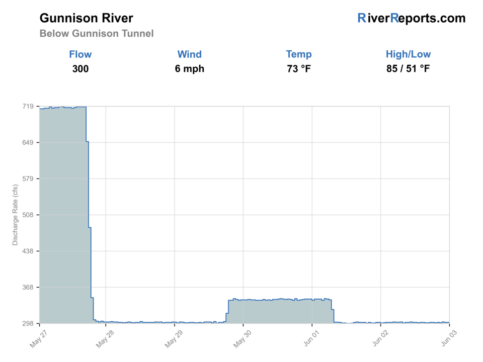
USGS data chart
Official USGS trend
Streamflow over the latest USGS reporting window.
Latest
300 cfs
Jun 3, 4 PM UTC
Weather
River weather report
Weather can change wading safety, road access, water temperature, hatches, and the best time of day to fish.
Live forecast loads as you reach this section
This keeps the report fast while still using the official National Weather Service forecast point.
Hatches and flies
Hatch chart and fly picks
Winter to early spring
Midges and small olives
Zebra midge, RS2, black beauty, pheasant tail
Spring
BWOs, caddis, stoneflies
BWO emerger, caddis pupa, Pat's rubber legs, hare's ear
Summer
Caddis, PMDs, yellow sallies, terrestrials
Elk hair caddis, PMD, yellow sally, ant, hopper
Fall
BWOs, midges, October caddis
BWO dry, zebra midge, October caddis pupa, sculpin streamer
Nymphs
Pheasant tail, perdigon, caddis pupa, zebra midge, stonefly nymph
Use through slots, deep seams, and canyon runs when fish are not rising.
Dry flies
BWO, caddis, PMD, parachute Adams, foam ant
Use during clear hatch windows and soft edge water.
Dry-droppers
Chubby, stimulator, hopper, tungsten dropper
Use in broken pocket water when flows are safe and fish will move.
Streamers
Sculpin, leech, bugger, sparkle minnow
Use in low light, deeper canyon banks, or slightly stained water.
Tactics
How to fish it
Decide whether the day is a hike-in, East Portal, or float-supported plan before choosing gear.
Keep nymph rigs simple enough to re-tie on rock shelves and windy banks.
Fish the near edge thoroughly before wading into canyon current.
Carry more water and emergency margin than a roadside trout day would require.
Do not continue downstream without a realistic exit plan.
Rigging
Rod, leader, and setup notes
A 9-foot 5-weight covers most nymph and dry-fly work.
Carry a 6-weight or sink-tip option only if streamers are a real part of the plan.
Use 4X to 6X tippet for most nymphs and dries.
Bring extra leaders, split shot, and indicators because canyon snags are common.
Use traction, sun protection, and a compact first-aid kit.
Access
Access and planning notes
East Portal / park context
Controlled canyon planWade / float / trail
NPS / road / wade
When to pick it
Start here when park access, rules, flow, and weather are all aligned.
Caution
Park rules and road status can change the plan quickly.
Gunnison Gorge NCA
Remote wade or float planningWade / float / trail
BLM / canyon / float / hike
When to pick it
Use it only when the group is prepared for steep access and a committed exit.
Caution
Heat, storms, limited shade, and rescue difficulty matter as much as the fish.
Gunnison Gorge Wilderness
Hike-in route checkWade / float / trail
Wilderness / hike / wade
When to pick it
Pick it when the goal is a serious backcountry-style fishing day.
Caution
Confirm route, permits, water, weather, and exit time before going.
NPS says East Portal Road is steep, has hairpin turns, restricts longer vehicles, and closes in winter.
BLM day-use and camping fees can apply in Gunnison Gorge Wilderness.
Inner-canyon access is not a casual roadside walk and should be treated as a strenuous route.
Private guides and outfitters may operate under permits; self-guided anglers still need to follow BLM and NPS rules.
Regulations
Check before fishing
NPS lists artificial flies or lures only, catch-and-release for rainbow trout, brown trout limits, license requirements, and a closure within 200 yards downstream of Crystal Dam for the park/Curecanti East Portal reach. Always verify current CPW, NPS, and BLM rules before fishing.
Primary base
Montrose, Delta, or Crawford, Colorado
Best day style
Steep canyon hikes, East Portal, BLM wilderness routes, and float logistics
Check first
Below-tunnel flow, NPS and BLM access, permits, weather, regulations
Safety
Steep terrain, remote exits, high flows, heat, limited service, winter closures
Gear
Helpful gear for this water
Canyon pack
Carry water, layers, food, map, first aid, and emergency communication.
Wading staff and traction
Useful on slick canyon rock and uneven river edges.
Compact fly kit
Bring confidence patterns instead of overpacking for the hike.
Sun and heat protection
Exposed canyon weather can be harsh even when the water is cold.
Nearby water
Other water to research
Backup logic
High water
Compare Lower Gunnison, Upper Gunnison, or a smaller western Colorado stream rather than forcing canyon wading.
Heat
Avoid midday canyon heat and stop trout pressure if water or handling conditions become stressful.
Storms or stain
Delay canyon trips when thunderstorms, muddy access, or lightning make exit timing uncertain.
Access issue
Use NPS or BLM-listed access only; choose another route if permits, road status, or route choice are unclear.
Lower Gunnison River
A downstream Gunnison plan with easier valley and Delta-area flow context.
Cimarron River
A smaller high-country Gunnison basin option near Silver Jack Reservoir.
Dolores River
A southwest Colorado tailwater and canyon river with release-dependent planning.
FAQ
Fast answers
Is Gunnison Gorge of the Black Canyon fishable today?
Gunnison Gorge of the Black Canyon looks very fishable right now. The live score is 96/100, based on current flow, weather, public alerts, and the report's planning context. Recheck the linked gauge and forecast before leaving because conditions can change quickly after rain, heat, access changes, or flow swings.
What flow is best for Gunnison Gorge of the Black Canyon?
Use the RiverReports Gunnison Tunnel chart and USGS 09128000 together. Stable releases are the cleanest planning signal; sudden changes, high pushy water, or flows that erase safe edge water should move you to a different reach or a different day.
When should I skip Gunnison Gorge of the Black Canyon?
Skip the Gorge when you are not prepared for the hike or float logistics, when heat or thunderstorms raise canyon risk, when NPS or BLM rules are unclear for the exact water you plan to fish, or when release changes make safe wading unrealistic.
Is Gunnison Gorge of the Black Canyon safe to wade right now?
The fishability score is not a wading guarantee. Wade only where your chosen access has safe edges, clear footing, legal entry, and no forced crossings; high, rising, stained, or storm-affected water should be treated conservatively.
Is the Gunnison Gorge beginner friendly?
No. Some access, especially inner-canyon and wilderness routes, is steep, remote, and physically demanding.
What flow should I check?
Use RiverReports and USGS 09128000 below the Gunnison Tunnel as the primary canyon flow reference.
Can I keep trout in the canyon?
Rules depend on the exact reach. NPS lists catch-and-release for rainbows and specific brown trout rules in its park reach, so verify current regulations before fishing.
What flies should I bring?
Bring midges, BWOs, caddis, stonefly nymphs, PMDs, terrestrials, dry-droppers, and streamers.
Sources
Source set for this report
Reviewed 2026-05-31