
California / West
Russian River at Talmage
Russian River at Talmage planning with RiverReports flow, official agency sources, NWS weather, access notes, hatch timing, fly picks, and practical safety guidance.
Image: Generated regional planning image for Russian River at Talmage / BlueStreamFly generated; not exact location / BlueStreamFlyFishability now: Russian River at Talmage fishability today
GreatData confidence: High91/100
Fishable now because the live gauge is stable, weather is mild, and no public alert is active.
Flow observed
4:30 PM UTC
Weather observed
5:00 PM UTC
Score calculated
5:25 PM UTC
Why this rating
Flow
Weather
Public alerts
Next 6-12 hours
Hold
Stable live data supports staying with the plan, but recheck the gauge and forecast before leaving.
USGS flow
81 cfs
Current trend: flow stable, so weather, temperature, and access checks drive the next change.
More planning details: flies, flow bands, and live source checks
Fish it today
Start here
Ukiah or Talmage is the practical base. Check cdfw low-flow status, usgs talmage flow, local rain, and legal public access, then pick a short legal access plan instead of trying to cover the whole river.
Best flow clue
Open under CDFW low-flow rules, dropping after rain, and clear enough to fish without stressing salmonids.
Skip trigger
Skip during closures, muddy storm spikes, hot low water, or private-access uncertainty.
Flow decision bands
Best starting window
Stable or gently falling live flow is the cleanest planning signal unless the route profile says otherwise.
Skip or scale back
Rising, stained, hot, or unsafe water should move the plan to banks, backup water, or a later check.
USGS flow
81 cfs
Current trend: flow stable, so weather, temperature, and access checks drive the next change.
Live USGS flow
82 cfs / stable
Live NWS forecast
67F / Sunny
Water temperature not verified
Heat guidance uses weather and river type unless an official water-temperature value is available.
No NWS alert flag
No active NWS alert was returned for this forecast point.
Use RiverReports for a quick chart and USGS 11462080 for official flow context.
CDFW low-flow status, USGS Talmage flow, local rain, and legal public access
Treat Talmage as a reach-specific planning page, not a blanket access map; verify public parking and land status before walking banks.
Flashy storm flow, private banks, warm low water, and limited public pullouts
Editorial review
How this report is maintained
This report uses official regulation, flow, weather, access, and public-source material first, then adds practical angler planning guidance without replacing current rules.
Byline
BlueStreamFly editorial desk
Reviewed by
BlueStreamFly source review
Maintained by
BlueStreamFly
Last material review
2026-05-29
Report confidence
Moderate confidence
76/100
Moderate confidence: RiverReports, USGS flow, California low-flow and steelhead sources, National Weather Service data, and watershed context support the report. Confidence is lower because the page still lacks a strong named public-access source and relies on generated regional imagery for media.
Regulations
California low-flow and steelhead-card sources support the legal-check path for upper Russian planning.
Access
The current public source set gives watershed context but not a strong named public-access page for this exact Talmage corridor.
Flow and weather
RiverReports, USGS 11462080, and the National Weather Service point resolved during review.
Fishing usefulness
The report gives practical low-flow, heat, and reach-selection guidance, but access confidence is intentionally limited until a stronger official public-access source is added.
Reviewed planning update
2026-05-29 / material content or source review
RiverReports, USGS Russian River near Talmage flow data, California low-flow and steelhead sources, Russian River watershed and marine-protected-area context, National Weather Service data, and the generated regional image credit were checked before adding the report-confidence meter.
2026-05-29
Added a page-specific report-confidence meter for Russian River at Talmage flow, regulation, weather, upper-river sensitivity, and limited-access planning guidance.
2026-05-25
Published a new fishing report with flow, weather, hatch, fly, tactics, access, regulation, source, image-credit, and trip-planning sections.
Angler planning edge
Local details that change the plan
Best for
Legal coastal salmonid windows, Flow-timing trips, Anglers who check rules before driving
Wade or float
Wade from known legal access first. Float plans need current landings, safe flow, and local knowledge.
Best flows
Open under CDFW low-flow rules, dropping after rain, and clear enough to fish without stressing salmonids.
When to skip
Skip during closures, muddy storm spikes, hot low water, or private-access uncertainty.
Local plan
Ukiah or Talmage is the practical base. Check cdfw low-flow status, usgs talmage flow, local rain, and legal public access, then pick a short legal access plan instead of trying to cover the whole river.
Pressure
Pressure concentrates around open legal windows, easy bridges, hatchery or park access, and the first clearing days after storms.
Access nuance
Treat Talmage as a reach-specific planning page, not a blanket access map; verify public parking and land status before walking banks.
Backup water
Check nearby BlueStreamFly reports if the gauge, rules, or weather do not fit the plan.
About the river
Setting, character, and why it fishes the way it does.
Russian River at Talmage is an upper Russian River reach where low-flow protections, warm-season temperatures, and patchy public access shape the fly plan.
These North Coast systems can fish well when open, cool, and clearing, but they are built around salmonid conservation, private-land edges, and fast-changing storms.
Treat Talmage as a reach-specific planning page, not a blanket access map; verify public parking and land status before walking banks.
Target species
Steelhead
Legal-season target only when low-flow status and current rules allow fishing.
Coho and Chinook salmon
Conservation-sensitive; avoid targeting closed or spawning fish.
Smallmouth bass
A more realistic warm-season fly target in suitable lower-gradient water.
Resident trout
Possible in cooler connected habitat, but temperature and rules decide the plan.
Reading the water
Open winter flow
Best for careful salmonid scouting when the river is dropping and clear.
Warm low water
Shift away from trout or steelhead pressure and consider warmwater tactics only where legal.
Storm spike
Wait for safer banks and better visibility.
Clear pressured water
Use smaller flies, longer leaders, and avoid visible salmonids.
Best seasons
October to April
Main regulation-first window for coastal salmonid planning. Low-flow rules and storms matter more than the date.
Winter
Best for steelhead-style trips when the river is open, dropping, and clear enough to fish without stressing salmonids.
Spring
Useful for clearing-flow scouting, small hatches, and careful access checks after storms have settled.
Summer
Often a scouting or warmwater season. Avoid salmonid pressure when water is warm, low, or closed.
Preferred flow source
Russian River near Talmage
RiverReports is the preferred chart source when coverage exists. When a matching USGS gauge exists, keep it open as the official backstop for station data and current hydrograph context.
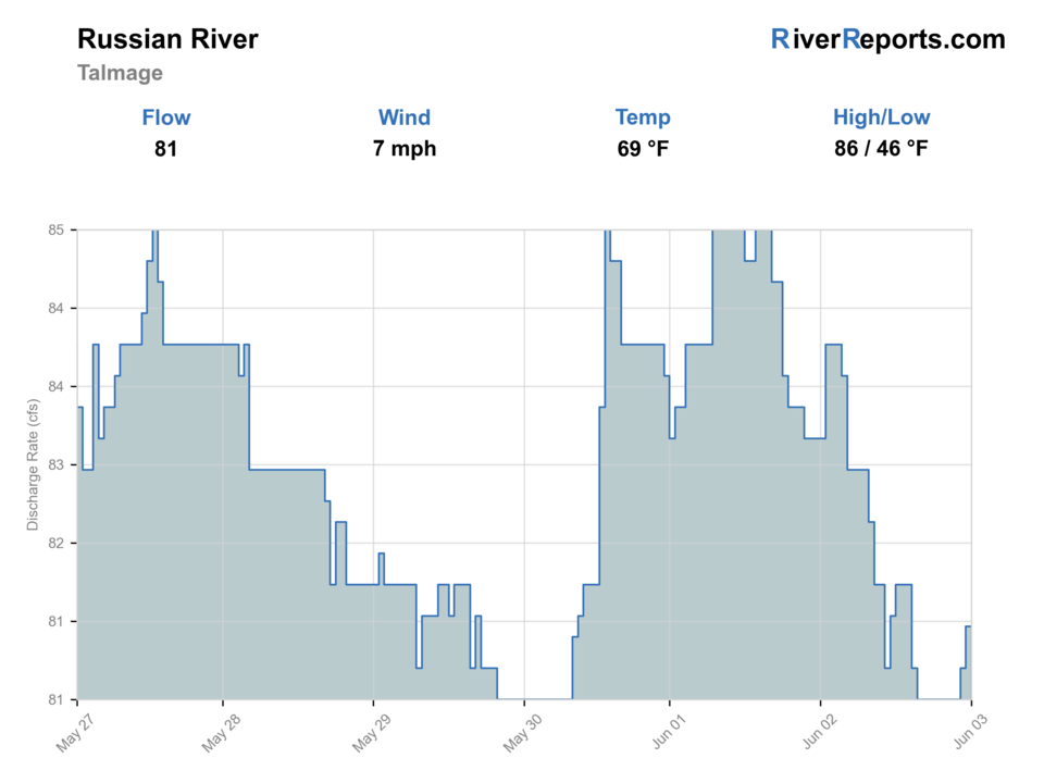
USGS data chart
Official USGS trend
Streamflow over the latest USGS reporting window.
Latest
81 cfs
Jun 3, 3 PM UTC
Weather
River weather report
Weather can change wading safety, road access, water temperature, hatches, and the best time of day to fish.
Live forecast loads as you reach this section
This keeps the report fast while still using the official National Weather Service forecast point.
Hatches and flies
Hatch chart and fly picks
Winter
Sparse midges, winter stones, eggs where legal, sculpins, and baitfish movement
Black stone, egg pattern where legal, soft hackle, black leech, sparse wet fly
Spring
BWOs, caddis, small mayflies, fry movement, and sculpins
BWO emerger, caddis pupa, soft hackle, sculpin, small clouser
Summer
Terrestrials, caddis, midges, warmwater forage, and estuary bait
Foam ant, small caddis, popper, baitfish streamer, crayfish
Fall
First rain pulses, small olives, caddis, and migration cues
Soft hackle, BWO, small streamer, muddler, sparse steelhead wet fly
Steelhead and salmonid flies
Sparse wet fly, black leech, egg pattern where legal, muddler, small intruder
Use only when the river is open, cool, and fishable.
Search streamers
Sculpin, clouser, olive bugger, black bugger, small baitfish
Use on clearing flows, deeper bends, shaded cutbanks, and soft edges.
Light-water flies
BWO emerger, caddis pupa, soft hackle, small nymph, foam ant
Use in low clear water or smaller legal side water when a lighter presentation fits.
Tactics
How to fish it
Check open status before leaving home, then match the gauge to clarity when you arrive.
Swing sparse flies or small streamers through soft traveling lanes only when the river is legal and fishable.
Avoid redds, staging fish, and crowded slots; these rivers depend on careful handling.
Keep a backup plan because coastal rivers can close or blow out quickly.
Rigging
Rod, leader, and setup notes
A 7- or 8-weight with floating and light sink-tip options covers legal winter salmonid work.
Carry sparse wet flies, leeches, small baitfish patterns, and barbless hooks.
Use short leaders when swinging sink tips and longer leaders in clear low water.
Bring rain gear, a wading staff, and a backup plan for closures or dirty water.
Access
Access and planning notes
Talmage and Ukiah corridor
Access checkWade / float / trail
Match to local conditions
When to pick it
Use legal parking and confirm land status before stepping off public right-of-way.
Caution
Confirm current rules, legal access, and water safety before committing.
Bridge-scouting reaches
Access checkWade / float / trail
Match to local conditions
When to pick it
Useful for reading color and flow; not every bridge offers legal fishing access.
Caution
Confirm current rules, legal access, and water safety before committing.
Russian River downstream backup
Access checkWade / float / trail
Match to local conditions
When to pick it
The Guerneville-focused page covers a different lower-river plan.
Caution
Confirm current rules, legal access, and water safety before committing.
Treat Talmage as a reach-specific planning page, not a blanket access map; verify public parking and land status before walking banks.
Confirm parking, land ownership, launch status, and current agency notices before relying on any access point.
Flashy storm flow, private banks, warm low water, and limited public pullouts
Regulations
Check before fishing
Check CDFW low-flow rules, current sport fishing regulations, and steelhead report-card requirements before fishing. Open status can change during the season.
Primary base
Ukiah or Talmage
Best day style
Upper river, bridge scouting, low-flow checks, and private-land caution
Check first
CDFW low-flow status, USGS Talmage flow, local rain, and legal public access
Safety
Flashy storm flow, private banks, warm low water, and limited public pullouts
Gear
Helpful gear for this water
7- or 8-weight rod
Appropriate for legal winter steelhead water and bigger coastal flows.
Sink-tip option
Useful for deeper travel lanes and post-storm color.
Steelhead card
Required when fishing for steelhead in California anadromous waters.
Rain and safety kit
Coastal storms, cold water, and remote bars require conservative packing.
Nearby water
Other water to research
Backup logic
Primary plan slips
Compare Russian River, Navarro River, Eel River only after checking current rules, access, and safety.
Russian River
Lower Sonoma County Russian River flow and park-access planning.
Navarro River
A Mendocino coast low-flow-rule river.
Eel River
A larger North Coast salmonid system with different timing.
FAQ
Fast answers
Is Russian River at Talmage fishable today?
Russian River at Talmage looks very fishable right now. The live score is 91/100, based on current flow, weather, public alerts, and the report's planning context. Recheck the linked gauge and forecast before leaving because conditions can change quickly after rain, heat, access changes, or flow swings.
What flow is best for Russian River at Talmage?
Open under CDFW low-flow rules, dropping after rain, and clear enough to fish without stressing salmonids.
When should I skip Russian River at Talmage?
Skip during closures, muddy storm spikes, hot low water, or private-access uncertainty.
Is Russian River at Talmage safe to wade right now?
The fishability score is not a wading guarantee. Wade only where your chosen access has safe edges, clear footing, legal entry, and no forced crossings; high, rising, stained, or storm-affected water should be treated conservatively.
Is Russian River at Talmage usually open for fly fishing?
Do not assume it is open. Low-flow rules, salmonid protections, and current sport-fishing regulations decide the legal plan.
Should I wade or float?
Wade from known legal access first. Float plans need current landings, safe flow, and local knowledge.
Which flow source should I use?
Use the RiverReports chart for a fast read and USGS 11462080 as the official flow source or context source.
Sources
Source set for this report
Reviewed 2026-05-29